Navigation and Bathymetry Points of Ship Position During Continuous Resistivity Profile Data Collection in the Corsica River Estuary, Maryland on May 17, 2007 on USGS Cruise 07005 f(RESGPSPNTS_JD137.SHP)

Metadata also available as - [Questions & Answers] - [Parseable text] - [XML]

Metadata:

Identification_Information:
Citation:
Citation_Information:
Originator: John F. Bratton
Originator: VeeAnn A. Cross
Publication_Date: 2011
Title:
Navigation and Bathymetry Points of Ship Position During Continuous Resistivity Profile Data Collection in the Corsica River Estuary, Maryland on May 17, 2007 on USGS Cruise 07005 f(RESGPSPNTS_JD137.SHP)
Geospatial_Data_Presentation_Form: vector digital data
Series_Information:
Series_Name: Open-File Report
Issue_Identification: 2010-1094
Publication_Information:
Publication_Place: Woods Hole Coastal and Marine Science Center, Woods Hole, MA
Publisher: U.S. Geological Survey, Coastal and Marine Geology Program
Online_Linkage: https://doi.org/10.3133/ofr20101094
Online_Linkage: https://pubs.usgs.gov/of/2010/1094/html/catalog.html
Online_Linkage: Larger_Work_Citation:
Citation_Information:
Originator: VeeAnn A. Cross
Originator: John F. Bratton
Originator: Charles R. Worley
Originator: John Crusius
Originator: Kevin D. Kroeger
Publication_Date: 2011
Title:
Continuous resistivity profiling data from the Corsica River Estuary, Maryland
Series_Information:
Series_Name: Open-File Report
Issue_Identification: 2010-1094
Publication_Information:
Publication_Place: Reston, VA
Publisher: U.S. Geological Survey
Online_Linkage: https://pubs.usgs.gov/of/2010/1094/
Description:
Abstract:
Submarine groundwater discharge (SGD) into Maryland's Corsica River Estuary was investigated as part of a larger study to determine the importance of nutrient delivery to Chesapeake Bay via this pathway. Resource managers are concerned about nutrients that are entering the estuary via submarine groundwater discharge from this primarily agricultural watershed that may be contributing to eutrophication, harmful algal blooms, and fish kills. An interdisciplinary U.S. Geological Survey (USGS) science team conducted field operations in the estuary in April and May 2007. Techniques used included continuous resistivity profiling (CRP), piezometer sampling, seepage meter measurements, and collection of a radon tracer time series. Better understanding of the style, locations, and rates of groundwater discharge could lead to improved models and mitigation strategies for estuarine nutrient over-enrichment in the Corsica River Estuary, and other similar settings. More information on the field work can be accessed from the Woods Hole Coastal and Marine Science Center Field Activity webpage: https://cmgds.marine.usgs.gov/fan_info.php?fan=2007-005-FA.
Purpose:
The purpose of this point shapefile is to provide the ship's position and bathymetric values (when available) during the collection of continuous resistivity profile data in the Corsica River Estuary, Maryland on May 17, 2007.
Time_Period_of_Content:
Time_Period_Information:
Single_Date/Time:
Calendar_Date: 20070517
Currentness_Reference: ground condition
Status:
Progress: Complete
Maintenance_and_Update_Frequency: None planned
Spatial_Domain:
Bounding_Coordinates:
West_Bounding_Coordinate: -76.149917
East_Bounding_Coordinate: -76.108067
North_Bounding_Coordinate: 39.086267
South_Bounding_Coordinate: 39.074783
Keywords:
Theme:
Theme_Keyword_Thesaurus: USGS Metadata Identifier
Theme_Keyword: USGS:848e3d3f-da0b-4016-972e-cc180ca53134
Theme:
Theme_Keyword_Thesaurus: None
Theme_Keyword: U.S. Geological Survey
Theme_Keyword: USGS
Theme_Keyword: Coastal and Marine Geology Program
Theme_Keyword: CMGP
Theme_Keyword: Woods Hole Coastal and Marine Science Center
Theme_Keyword: WHCMSC
Theme_Keyword: Field Activity Serial Number 07005
Theme_Keyword: Field Activity Number 2007-005-FA
Theme_Keyword: Info Bank ID T-1-07-CH
Theme_Keyword: navigation
Theme_Keyword: bathymetry
Theme_Keyword: point
Theme_Keyword: shapefile
Theme_Keyword: Continuous Resistivity Profiling
Theme_Keyword: CRP
Theme_Keyword: Lowrance GPS
Theme_Keyword: R/V Terrapin
Theme:
Theme_Keyword_Thesaurus: ISO 19115 Topic Category
Theme_Keyword: elevation
Theme_Keyword: inlandWaters
Theme_Keyword: location
Theme_Keyword: oceans
Theme:
Theme_Keyword_Thesaurus: USGS Thesaurus
Theme_Keyword: navigational data
Theme_Keyword: bathymetry
Theme_Keyword: geospatial datasets
Place:
Place_Keyword_Thesaurus: None
Place_Keyword: North America
Place_Keyword: North Atlantic
Place_Keyword: United States
Place_Keyword: Maryland
Place_Keyword: Corsica River Estuary
Place_Keyword: Chesapeake Bay
Access_Constraints: None.
Use_Constraints:
The public domain data from the U.S. Government are freely redistributable with proper metadata and source attribution. Please recognize the U.S. Geological Survey as the originator of the dataset.
Point_of_Contact:
Contact_Information:
Contact_Person_Primary:
Contact_Person: John F. Bratton
Contact_Organization: U.S. Geological Survey
Contact_Address:
Address_Type: mailing and physical address
Address: Woods Hole Coastal and Marine Science Center
Address: 384 Woods Hole Rd.
City: Woods Hole
State_or_Province: MA
Postal_Code: 02543-1598
Contact_Voice_Telephone: (508) 548-8700 x2254
Contact_Facsimile_Telephone: (508) 457-2310
Contact_Electronic_Mail_Address: jbratton@usgs.gov
Contact_Instructions:
Current address: NOAA/GLERL 4840 S. State Rd. Ann Arbor MI 48108-9719 734-741-2235 John.Bratton@noaa.gov
Browse_Graphic:
Browse_Graphic_File_Name: Browse_Graphic_File_Description:
Thumbnail image showing the location of resistivity navigation points collected May 17, 2007. The coastline is included for spatial reference.
Browse_Graphic_File_Type: GIF
Native_Data_Set_Environment:
Microsoft Windows XP Version 5.1 (Build 2600) Service Pack 3; ESRI ArcCatalog 9.2.6.1500
Data_Quality_Information:
Logical_Consistency_Report:
No duplicate points are present. The navigational fixes were checked for valid values. Invalid data points were deleted. No other checks were performed.
Completeness_Report:
All available navigation, bathymetry and temperature information available on this day is included in the dataset.
Positional_Accuracy:
Horizontal_Positional_Accuracy:
Horizontal_Positional_Accuracy_Report:
The navigation system used was a Lowrance 480M with an LGC-2000 Global Positioning System (GPS) antenna. The antenna was located at the anchor point for the resistivity streamer, which is also directly above the fathometer transducer mount point. The GPS system is published to be accurate to within 10 meters.
Vertical_Positional_Accuracy:
Vertical_Positional_Accuracy_Report:
All collected bathymetry values were collected by the 200 kHz Lowrance fathometer. The fathometer was mounted starboard side aft, directly below the GPS antenna and the resistivity streamer tow point. The Lowrance manufacturer indicates the speed of sound used by the system to convert to depths is 4800 feet/second. All values are assumed to be accurate to within 1 meter.
Lineage:
Process_Step:
Process_Description:
The continuous resistivity profile (CRP) system used on this cruise was an AGI SuperSting marine system described at the website: www.agiusa.com/marinesystem.shtml. The particular system used for this acquisition was a 50-m streamer with an 11 electrode array with electrodes spaced 5 meters apart. The source electrodes are graphite, while the receiver electrodes are stainless steel. A dipole-dipole configuration was used for the data collection in which two fixed current electrodes are assigned with the measurement of voltage potential between electrode pairs in the remaining electrodes. The maximum depth below the water surface the streamer can reach is approximately ¼ the streamer length. So for the 50-m streamer, maximum depth is about 12.5 meters. Each line of data acquisition records several files. The two files necessary for processing are the *.stg and the *.gps file. The STG file contains the resistivity data, while the GPS file contains the navigation information. The navigation system used in concert with the CRP system is a Lowrance LMS-480M with an LGC-2000 GPS antenna and a 200 kHz fathometer transducer. The transducer also contains a temperature sensor. Lowrance indicates the speed of sound used by the system is 4800 feet/second. Both the temperature and depth information are recorded in the logged GPS file. There are instances where no depth or temperature information is recorded due to an equipment problem. The CRP system images the subsurface electrical properties of an estuarine, riverine or lacustrine environment. Resistivity differences can be attributed to subsurface geology (conductive vs less conductive layers) and hydrogeologic conditions with fresh water exhibiting high resistivity and saline conditions showing low resistivity.
Process_Date: 2007
Process_Step:
Process_Description:
The data were transferred from the logging computer via AGISSAdmin software version 1.3.2.165. The data files available for this day are L37F1*, L38F1*, L39F1*, L39F2*, L40F1*, L41F1*, L42F1*, L43F1*, L44F1*, L45F1*, L46F1*, L47F1*, L48F1*, L49F1*, L49F2*, L50F1*, L51F1*, L52F1*, L53F1*, L54F1*, L54F2*, L55F1*, L55F2*, L56F1*, L57F1*, L58F1*, l58F2*, L59F1*, L60F1*, L61F1*, L62F1*, L63F1*, L64F1*, L65F1*, L66F1*, L67F1*, L68F1*, L69F1*, L70F1*, L71F1*, L72F1*, L73F1*, L74F1*, L75F1*. These files were then transferred via a thumb drive to the processing computer. The files included in this publication are the *.crs, *.cmd, *.gps, and *.stg. The two files essential for processing are the GPS and STG files. The GPS file contains the navigation, and in the case of the Lowrance system also includes water depth and temperature. The STG file contains the resistivity measurements from each of the electrodes. The CRS file contains the contact resistance readings. The CMD file contains the parameters for data collection. These last two files aren't necessary for data processing, but can be useful in terms of troubleshooting. This process step, along with all subsequent process steps, was performed by the same person: VeeAnn A. Cross
Process_Date: 2007
Process_Contact:
Contact_Information:
Contact_Person_Primary:
Contact_Person: VeeAnn A. Cross
Contact_Organization: U.S. Geological Survey
Contact_Position: Marine Geologist
Contact_Address:
Address_Type: mailing and physical address
Address: Woods Hole Coastal and Marine Science Center
Address: 384 Woods Hole Rd.
City: Woods Hole
State_or_Province: MA
Postal_Code: 02543-1598
Contact_Voice_Telephone: (508) 548-8700 x2251
Contact_Facsimile_Telephone: (508) 457-2310
Contact_Electronic_Mail_Address: vatnipp@usgs.gov
Process_Step:
Process_Description:
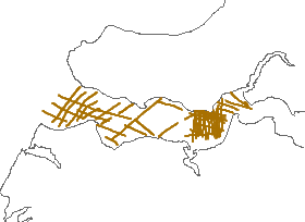
An AWK script was used to extract the navigation, Bathymetry, and temperature information recorded in each individual GPS data file. (* refers to the line name, which for this day are L37F1, L38F1, L39F1, L39F2, L40F1, L41F1, L42F1, L43F1, L44F1, L45F1, L46F1, L47F1, L48F1, L49F1, L49F2, L50F1, L51F1, L52F1, L53F1, L54F1, L54F2, L55F1, L55F2, L56F1, L57F1, L58F1, l58F2, L59F1, L60F1, L61F1, L62F1, L63F1, L64F1, L65F1, L66F1, L67F1, L68F1, L69F1, L70F1, L71F1, L72F1, L73F1, L74F1, L75F1.) The awk script from May 16th that was able to handle all problems was used on this day's data.
AWK script "awkhold":
BEGIN {
FS = ","
}
{
FS = ","
ARGC = 2
depth = -9999
temp = -9999
if ($1=="$GPRMC")
	{
	utctime = $2
	latdeg = substr($4,1,2)
	latmin = substr($4,3,6)
	declat = latdeg + (latmin/60)
	londeg = substr($6,1,3)
	lonmin = substr($6,4,6)
	declon = -1 * (londeg + (lonmin/60))
	if (NR==1) {
		holddepth = -9999
		holdtemp = -9999
		}
	else {
		printf("%s, %9.6f, %9.6f, %5.1f, %5.1f, %s\n", holdutctime, holddeclon, holddeclat, holddepth, holdtemp, ARGV[2])
	}
	holdutctime = utctime
	holddeclon = declon
	holddeclat = declat
	holddepth = -9999
	holdtemp = -9999
	}
if ($1=="$SDDPT")
	{
	depthreal = $2
	holddepth = depthreal
	}
if ($1=="$SDMTW")
	{
	tempreal = $2
	holdtemp = tempreal
	}
}
END {
printf("%s, %9.6f, %9.6f, %5.1f, %5.1f, %s\n", holdutctime, holddeclon, holddeclat, holddepth, holdtemp, ARGV[2])
}
This AWK script was initialized by "dohold" - shell script run under CYGWIN (UNIX like environment that runs under Windows):
files=`ls *.gps | cut -d. -f1 | tr "[A-Z"] ["a-z"]`
for file in $files
do
	awk -f awkhold $file.gps $file > $file.holds
done
Source_Used_Citation_Abbreviation: *.gps
Process_Date: 2007
Source_Produced_Citation_Abbreviation: *.holds
Process_Step:
Process_Description:
These files were then appended to each other using the UNIX cat command. cat l37f1.holds l38f1.holds l39f1.holds l39f2.holds l40f1.holds l41f1.holds l42f1.holds l43f1.holds l44f1.holds l45f1.holds l46f1.holds l47f1.holds l48f1.holds l49f1.holds l49f2.holds l50f1.holds l51f1.holds l52f1.holds l53f1.holds l54f1.holds l54f2.holds l55f1.holds l55f2.holds l56f1.holds l57f1.holds l58f1.holds l58f2.holds l59f1.holds l60f1.holds l61f1.holds l62f1.holds l63f1.holds l64f1.holds l65f1.holds l66f1.holds l67f1.holds l68f1.holds l69f1.holds l70f1.holds l71f1.holds l72f1.holds l73f1.holds l74f1.holds l75f1.holds > day3holds.txt
Source_Used_Citation_Abbreviation: *.holds
Process_Date: 2007
Source_Produced_Citation_Abbreviation: day3holds.txt
Process_Step:
Process_Description:
VI under CYGWIN was used to add the appropriate header line and the comma-delimited text file was imported to ArcMap 9.1: Tools - Add XY Data. The X field is longitude; Y field is latitude, and the Coordinate System was defined as Geographic, NAD83. This "Event Theme" was converted to a shapefile by right-mouse clicking on the layer - Data - Export Data. The output was saved as day3gps.shp
Source_Used_Citation_Abbreviation: day3holds.txt
Process_Date: 2007
Source_Produced_Citation_Abbreviation: day3gps.shp
Process_Step:
Process_Description:
Visual inspection of the shapefile indicated that the navigation was fine and needed no editing.
Source_Used_Citation_Abbreviation: day3gps.shp
Process_Date: 2007
Source_Produced_Citation_Abbreviation: day3gps.shp
Process_Step:
Process_Description:
Within ArcCatalog 9.2 the shapefile was copied to a new file with the name resgpspnts_jd137.shp.
Source_Used_Citation_Abbreviation: day3gps.shp
Process_Date: 200911
Source_Produced_Citation_Abbreviation: resgpspnts_jd137.shp
Process_Step:
Process_Description:
Using ArcMap 9.2 added the attributes "gps_src' and "bathy_src" to be consistent with previously published data in cases where other sources were used for navigation and/or bathymetry.
Source_Used_Citation_Abbreviation: resgpspnts_jd137.shp
Process_Date: 200911
Source_Produced_Citation_Abbreviation: resgpspnts_jd137.shp
Process_Step:
Process_Description:
Edits to the metadata were made to fix any errors that MP v 2.9.36 flagged. This is necessary to enable the metadata to be successfully harvested for various data catalogs. In some cases, this meant adding text "Information unavailable" or "Information unavailable from original metadata" for those required fields that were left blank. Other minor edits were probably performed (title, publisher, publication place, etc.). Attempted to modify http to https where appropriate. Reordered the links in the identification section to have a landing page link as the first link. Updated the link to the field activity. Moved the minimal source information provided to make it the first process step. The distribution format name was modified in an attempt to be more consistent with other metadata files of the same data format. The metadata date (but not the metadata creator) was edited to reflect the date of these changes. The metadata available from a harvester may supersede metadata bundled within a download file. Compare the metadata dates to determine which metadata file is most recent.
Process_Date: 20171018
Process_Contact:
Contact_Information:
Contact_Organization_Primary:
Contact_Organization: U.S. Geological Survey
Contact_Person: VeeAnn A. Cross
Contact_Position: Marine Geologist
Contact_Address:
Address_Type: Mailing and Physical
Address: 384 Woods Hole Road
City: Woods Hole
State_or_Province: MA
Postal_Code: 02543-1598
Contact_Voice_Telephone: 508-548-8700 x2251
Contact_Facsimile_Telephone: 508-457-2310
Contact_Electronic_Mail_Address: vatnipp@usgs.gov
Process_Step:
Process_Description: USGS Thesaurus keywords added to the keyword section.
Process_Date: 20180720
Process_Contact:
Contact_Information:
Contact_Organization_Primary:
Contact_Organization: U.S. Geological Survey
Contact_Person: VeeAnn A. Cross
Contact_Position: Marine Geologist
Contact_Address:
Address_Type: Mailing and Physical
Address: 384 Woods Hole Road
City: Woods Hole
State_or_Province: MA
Postal_Code: 02543-1598
Contact_Voice_Telephone: 508-548-8700 x2251
Contact_Facsimile_Telephone: 508-457-2310
Contact_Electronic_Mail_Address: vatnipp@usgs.gov
Process_Step:
Process_Description: Crossref DOI link was added as the first link in the metadata.
Process_Date: 20191118
Process_Contact:
Contact_Information:
Contact_Organization_Primary:
Contact_Organization: U.S. Geological Survey
Contact_Person: VeeAnn A. Cross
Contact_Position: Marine Geologist
Contact_Address:
Address_Type: Mailing and Physical
Address: 384 Woods Hole Road
City: Woods Hole
State_or_Province: MA
Postal_Code: 02543-1598
Contact_Voice_Telephone: 508-548-8700 x2251
Contact_Facsimile_Telephone: 508-457-2310
Contact_Electronic_Mail_Address: vatnipp@usgs.gov
Process_Step:
Process_Description:
Added keywords section with USGS persistent identifier as theme keyword.
Process_Date: 20200908
Process_Contact:
Contact_Information:
Contact_Organization_Primary:
Contact_Organization: U.S. Geological Survey
Contact_Person: VeeAnn A. Cross
Contact_Position: Marine Geologist
Contact_Address:
Address_Type: Mailing and Physical
Address: 384 Woods Hole Road
City: Woods Hole
State_or_Province: MA
Postal_Code: 02543-1598
Contact_Voice_Telephone: 508-548-8700 x2251
Contact_Facsimile_Telephone: 508-457-2310
Contact_Electronic_Mail_Address: vatnipp@usgs.gov
Spatial_Data_Organization_Information:
Direct_Spatial_Reference_Method: Vector
Point_and_Vector_Object_Information:
SDTS_Terms_Description:
SDTS_Point_and_Vector_Object_Type: Entity point
Point_and_Vector_Object_Count: 3073
Spatial_Reference_Information:
Horizontal_Coordinate_System_Definition:
Geographic:
Latitude_Resolution: 0.000001
Longitude_Resolution: 0.000001
Geographic_Coordinate_Units: Decimal degrees
Geodetic_Model:
Horizontal_Datum_Name: North American Datum of 1983
Ellipsoid_Name: Geodetic Reference System 80
Semi-major_Axis: 6378137.000000
Denominator_of_Flattening_Ratio: 298.257222
Vertical_Coordinate_System_Definition:
Depth_System_Definition:
Depth_Datum_Name: Local surface
Depth_Resolution: 0.1
Depth_Distance_Units: meters
Depth_Encoding_Method: Explicit depth coordinate included with horizontal coordinates
Entity_and_Attribute_Information:
Detailed_Description:
Entity_Type:
Entity_Type_Label: resgpspnts_jd137
Entity_Type_Definition: ESRI point shapefile
Entity_Type_Definition_Source: ESRI
Attribute:
Attribute_Label: FID
Attribute_Definition: Internal feature number.
Attribute_Definition_Source: ESRI
Attribute_Domain_Values:
Unrepresentable_Domain:
Sequential unique whole numbers that are automatically generated.
Attribute:
Attribute_Label: Shape
Attribute_Definition: Feature geometry.
Attribute_Definition_Source: ESRI
Attribute_Domain_Values:
Unrepresentable_Domain: Coordinates defining the features.
Attribute:
Attribute_Label: gpstime
Attribute_Definition:
GPS time in the format HHMMSS. GPS time is +4 from local time during the survey.
Attribute_Definition_Source: U.S. Geological Survey
Attribute_Domain_Values:
Unrepresentable_Domain:
Although the value is represented as a number, the number as a whole doesn't have a particular meaning. Only when the individual parts for hours, minutes, and seconds are broken out does the number have meaning.
Attribute:
Attribute_Label: longitude
Attribute_Definition: Longitude coordinate of the point in decimal degrees, NAD83.
Attribute_Definition_Source: U.S. Geological Survey
Attribute_Domain_Values:
Range_Domain:
Range_Domain_Minimum: -76.149917
Range_Domain_Maximum: -76.108067
Attribute_Units_of_Measure: decimal degrees
Attribute:
Attribute_Label: latitude
Attribute_Definition: Latitude coordinate of the point in decimal degrees, NAD83.
Attribute_Definition_Source: U.S. Geological Survey
Attribute_Domain_Values:
Range_Domain:
Range_Domain_Minimum: 39.074783
Range_Domain_Maximum: 39.086267
Attribute_Units_of_Measure: decimal degrees
Attribute:
Attribute_Label: depth_m
Attribute_Definition:
Depth of the water below the fathometer in meters recorded by the ship's fathometer/navigation system. Datum is local surface (no tides taken into account). A value of -9999 indicates no data.
Attribute_Definition_Source: U.S. Geological Survey
Attribute_Domain_Values:
Range_Domain:
Range_Domain_Minimum: 0.2
Range_Domain_Maximum: 5
Attribute_Units_of_Measure: meters
Attribute:
Attribute_Label: temp_c
Attribute_Definition:
Water temperature in degrees Celsius as recorded at the Lowrance fathometer transducer. A value of -9999 indicated no data.
Attribute_Definition_Source: U.S. Geological Survey
Attribute_Domain_Values:
Range_Domain:
Range_Domain_Minimum: 20.6
Range_Domain_Maximum: 24.5
Attribute_Units_of_Measure: degrees Celsius
Attribute:
Attribute_Label: line
Attribute_Definition:
The alphanumeric name corresponding to the prefix of the GPS filename. This name reflects the name assigned to the line of data acquisition and incorporates modifiers to reflect modification of the GPS file if the GPS file was split into more than one part.
Attribute_Definition_Source: U.S. Geological Survey
Attribute_Domain_Values:
Unrepresentable_Domain: Character set.
Attribute:
Attribute_Label: jday
Attribute_Definition:
This number represents the Julian day of data collection based on the GPS day. Julian day is the integer number representing the interval of time in days since January 1 of the year.
Attribute_Definition_Source: U.S. Geological Survey
Attribute_Domain_Values:
Range_Domain:
Range_Domain_Minimum: 137
Range_Domain_Maximum: 137
Attribute_Units_of_Measure: days
Attribute:
Attribute_Label: gpsdate
Attribute_Definition:
The date recorded in the GPS navigation in the format DDMMYY. Because of the time offset from local time, this date could actually be different than the local acquisition date.
Attribute_Definition_Source: U.S. Geological Survey
Attribute_Domain_Values:
Unrepresentable_Domain: Character set.
Attribute:
Attribute_Label: gps_src
Attribute_Definition: The system from which the navigation point was derived.
Attribute_Definition_Source: U.S. Geological Survey
Attribute_Domain_Values:
Unrepresentable_Domain: Character set.
Attribute:
Attribute_Label: bathy_src
Attribute_Definition: The system from which the bathymetric value was acquired.
Attribute_Definition_Source: U.S. Geological Survey
Attribute_Domain_Values:
Unrepresentable_Domain: Character set.
Distribution_Information:
Distributor:
Contact_Information:
Contact_Person_Primary:
Contact_Person: VeeAnn A. Cross
Contact_Organization: U.S. Geological Survey
Contact_Position: Marine Geologist
Contact_Address:
Address_Type: mailing and physical address
Address: Woods Hole Coastal and Marine Science Center
Address: 384 Woods Hole Rd.
City: Woods Hole
State_or_Province: MA
Postal_Code: 02543-1598
Contact_Voice_Telephone: (508) 548-8700 x2251
Contact_Facsimile_Telephone: (508) 457-2310
Contact_Electronic_Mail_Address: vatnipp@usgs.gov
Resource_Description: Downloadable Data
Distribution_Liability:
Neither the U.S. government, the Department of the Interior, nor the USGS, nor any of their employees, contractors, or subcontractors, make any warranty, express or implied, nor assume any legal liability or responsibility for the accuracy, completeness, or usefulness of any information, apparatus, product, or process disclosed, nor represent that its use would not infringe on privately owned rights. The act of distribution shall not constitute any such warranty, and no responsibility is assumed by the USGS in the use of these data or related materials. Any use of trade, product, or firm names is for descriptive purposes only and does not imply endorsement by the U.S. Government.
Standard_Order_Process:
Digital_Form:
Digital_Transfer_Information:
Format_Name: Shapefile
Format_Version_Number: ArcGIS 9.2
Format_Information_Content:
This WinZip (version 9.0) file contains the point shapefile as well as the associated metadata files.
Transfer_Size: 0.136
Digital_Transfer_Option:
Online_Option:
Computer_Contact_Information:
Offline_Option:
Offline_Media: DVD-ROM
Recording_Capacity:
Recording_Density: 4.75
Recording_Density_Units: GBytes
Recording_Format: UDF
Fees: none
Technical_Prerequisites:
This WinZip file contains data available in ESRI point shapefile format. The user must have software capable of uncompressing the WinZip file and reading/displaying the shapefile.
Metadata_Reference_Information:
Metadata_Date: 20240318
Metadata_Contact:
Contact_Information:
Contact_Person_Primary:
Contact_Person: VeeAnn A. Cross
Contact_Organization: U.S. Geological Survey
Contact_Position: Marine Geologist
Contact_Address:
Address_Type: mailing and physical address
Address: Woods Hole Coastal and Marine Science Center
Address: 384 Woods Hole Rd.
City: Woods Hole
State_or_Province: MA
Postal_Code: 02543-1598
Contact_Voice_Telephone: (508) 548-8700 x2251
Contact_Facsimile_Telephone: (508) 457-2310
Contact_Electronic_Mail_Address: whsc_data_contact@usgs.gov
Contact_Instructions:
The metadata contact email address is a generic address in the event the person is no longer with USGS. (updated on 20240318)
Metadata_Standard_Name: FGDC Content Standards for Digital Geospatial Metadata
Metadata_Standard_Version: FGDC-STD-001-1998
Metadata_Time_Convention: local time

This page is <https://cmgds.marine.usgs.gov/catalog/whcmsc/open_file_report/ofr2010-1094/resgpspnts_jd137meta.html>
Generated by mp version 2.9.51 on Mon Mar 25 16:05:31 2024