Enhanced Grayscale GeoTIFF Image of the 1-m Sidescan-Sonar Data From National Oceanic and Atmospheric Administration (NOAA) Survey H11446 of the Sea Floor North of Orient Point, New York (H11446_SSS1M_UTM.TIF, UTM18, NAD83)

Metadata also available as - [Outline] - [Parseable text] - [XML]

Frequently anticipated questions:


What does this data set describe?

Title:
Enhanced Grayscale GeoTIFF Image of the 1-m Sidescan-Sonar Data From National Oceanic and Atmospheric Administration (NOAA) Survey H11446 of the Sea Floor North of Orient Point, New York (H11446_SSS1M_UTM.TIF, UTM18, NAD83)
Abstract:
The U.S. Geological Survey (USGS), in cooperation with the Connecticut Department of Environmental Protection and National Oceanic and Atmospheric Administration (NOAA), is producing detailed geologic maps of the coastal sea floor. Imagery, originally collected by NOAA for charting purposes, provides a fundamental framework for research and management activities along this part of Long Island Sound, shows the composition and terrain of the seabed, and provides information on sediment transport and benthic habitat. Interpretive data layers were derived from the multibeam echo-sounder data and sidescan-sonar data collected north of Orient Point, New York. During April 2010, bottom photographs and surficial sediment data were acquired as part of a USGS ground-truth reconnaissance survey. For more information on the ground-truth survey see http://quashnet.er.usgs.gov/data/2010/10010/.
  1. How might this data set be cited?
    U.S. Geological Survey, and National Oceanic and Atmospheric Administration, 2011, Enhanced Grayscale GeoTIFF Image of the 1-m Sidescan-Sonar Data From National Oceanic and Atmospheric Administration (NOAA) Survey H11446 of the Sea Floor North of Orient Point, New York (H11446_SSS1M_UTM.TIF, UTM18, NAD83): Open-File Report 2010-1100, U.S. Geological Survey, Coastal and Marine Geology Program, Woods Hole Coastal and Marine Science Center, Woods Hole, MA.

    Online Links:

    This is part of the following larger work.

    McMullen, K.Y., Poppe, L.J., Danforth, W.W., Blackwood, D.S., Schaer, J.D., Guberski, M.R., Wood, D.A., and Doran, E.F., 2011, Surficial Geology of the Sea Floor in Long Island Sound Offshore of Orient Point, New York: Open-File Report 2010-1100, U.S. Geological Survey, Reston, VA.

    Online Links:

    Other_Citation_Details: CD-ROM
  2. What geographic area does the data set cover?
    West_Bounding_Coordinate: -72.330835
    East_Bounding_Coordinate: -72.225052
    North_Bounding_Coordinate: 41.176653
    South_Bounding_Coordinate: 41.132569
  3. What does it look like?
    http://pubs.usgs.gov/of/2010/1100/data/sidescan/utm/h11446_sss1m_utm.gif (GIF)
    Thumbnail image showing the sidescan sonar imagery produced from data collected during NOAA survey H11446 in UTM
  4. Does the data set describe conditions during a particular time period?
    Beginning_Date: 22-Sep-2008
    Ending_Date: 21-Oct-2008
    Currentness_Reference:
    ground condition
  5. What is the general form of this data set?
    Geospatial_Data_Presentation_Form: remote-sensing image
  6. How does the data set represent geographic features?
    1. How are geographic features stored in the data set?
      This is a Raster data set. It contains the following raster data types:
      • Dimensions 4626 x 8741 x 1, type Pixel
    2. What coordinate system is used to represent geographic features?
      Grid_Coordinate_System_Name: Universal Transverse Mercator
      Universal_Transverse_Mercator:
      UTM_Zone_Number: 18
      Transverse_Mercator:
      Scale_Factor_at_Central_Meridian: 0.999600
      Longitude_of_Central_Meridian: -75.000000
      Latitude_of_Projection_Origin: 0.000000
      False_Easting: 500000.000000
      False_Northing: 0.000000
      Planar coordinates are encoded using row and column
      Abscissae (x-coordinates) are specified to the nearest 1.000000
      Ordinates (y-coordinates) are specified to the nearest 1.000000
      Planar coordinates are specified in meters
      The horizontal datum used is North American Datum of 1983.
      The ellipsoid used is Geodetic Reference System 80.
      The semi-major axis of the ellipsoid used is 6378137.000000.
      The flattening of the ellipsoid used is 1/298.257222.
  7. How does the data set describe geographic features?
    Entity_and_Attribute_Overview:
    A continuous-coverage sidescan sonar-image of NOAA survey H11446 in UTM. Data values in this grayscale image range from 0-254; a nodata value has been set to 255. There are a few places in the mosaic where sidescan coverage was not complete, and the data gaps do not have a value of 255.
    Entity_and_Attribute_Detail_Citation: U.S. Geological Survey

Who produced the data set?

  1. Who are the originators of the data set? (may include formal authors, digital compilers, and editors)
    • U.S. Geological Survey
    • National Oceanic and Atmospheric Administration
  2. Who also contributed to the data set?
  3. To whom should users address questions about the data?
    U.S. Geological Survey
    Attn: Katherine McMullen
    Field and Laboratory Technician
    384 Woods Hole Road
    Woods Hole, MA

    508-548-8700 x2277 (voice)
    508-457-2310 (FAX)
    kmcmullen@usgs.gov

Why was the data set created?

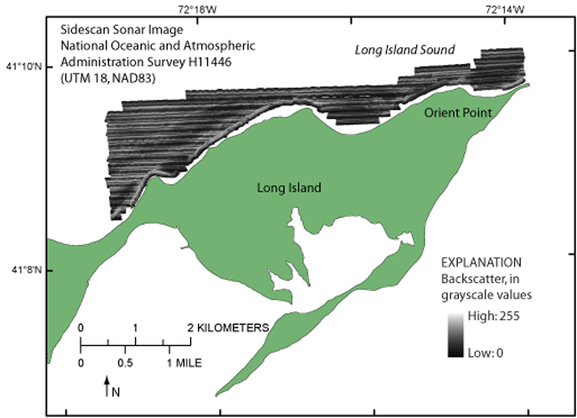
To release a GeoTIFF of the 1-m, 455-kHz sidescan-sonar data generated during NOAA survey H11446 in Long Island Sound, north of Orient Point, in UTM 18, NAD83 coordinate system.

How was the data set created?

  1. From what previous works were the data drawn?
    Information unavailable from original metadata. (source 1 of 1)
    The source information was incomplete and had to be modified to meet the standard. Assumed to be NOAA., unknown, The source information was incomplete and had to be modified to meet the standard..

    Type_of_Source_Media: DVD-ROM
    Source_Contribution:
    Original sidescan-sonar data acquired with Klein 5000 echosounders during NOAA survey H11446 aboard a launch deployed from the NOAA ship Thomas Jefferson.
  2. How were the data generated, processed, and modified?
    Date: 2008 (process 1 of 9)
    The sidescan-sonar data were acquired with Klein 5000 sidescan-sonar system hull mounted to a 29' aluminum launch deployed from the NOAA ship Thomas Jefferson. The system was set to sweep 100 m to either side of the launch tracks. The system has a vertical beam angle of 40 degrees and transmits at 455 kHz. The data were acquired in XTF (extended Triton data format), recorded digitally through an ISIS data acquisition system, and processed using CARIS SIPS (Sidescan Image Processing) software for quality control, and to produce a composite sidescan-sonar image at 1-m horizontal resolution. As part of this process, the sidescan-sonar data were demultiplexed and filtered to remove speckle noise and to correct for slant-range distortions. Image 'shine through', to account for areas of overlap, and auto-contrast adjustment were applied. Contrast enhancement based on the dynamic range of the data was applied to the mosaic and it was then projected into UTM Zone 18 to produce the final enhanced image. Person who carried out this activity:
    National Oceanic and Atmospheric Administration
    Attn: Jasper Schaer
    Field Operations Officer
    439 W. York Street
    Norfolk, VA
    USA

    757-441-6726 (voice)
    jasper.schaer@noaa.gov
    Data sources produced in this process:
    • h11446_SSS100_1mRes_mosaic_GeoTif.tif
    Date: 2010 (process 2 of 9)
    World file of GeoTIFF was created using GeoTiff Examine then GeoTIFF image was converted to 8-bit grayscale from 8-bit RGB and the grayscale was inverted such that high backscatter is white and low backscatter is black. Data values were set from 0-254 and white background was set as 255. Used Photoshop CS2. Person who carried out this activity:
    Katherine McMullen
    U.S. Geological Survey
    Field and Laboratory Technician
    384 Woods Hole Road
    Woods Hole, MA
    USA

    508-548-8700 x2277 (voice)
    508-457-2310 (FAX)
    kmcmullen@usgs.gov
    Data sources used in this process:
    • H11446_SSS100_1mRes_Mosaic_GeoTif.tif
    Data sources produced in this process:
    • H11446_SSS100_1mRes_Mosaic_GeoTif.tfw
    • H11446_SSS100_1mRes_Mosaic_GeoTif_inv.tif
    Date: 2010 (process 3 of 9)
    Copied world file from H11446_SSS100_1mRes_Mosaic_GeoTif.tif and renamed as H11446_SSS100_1mRes_Mosaic_GeoTif_inv.tfw. Used GeoTiff Examine to add the georeferencing information to the header making H11446_SSS100_1mRes_Mosaic_GeoTif_inv.tif. a GeoTIFF. Person who carried out this activity:
    Katherine McMullen
    U.S. Geological Survey
    Field and Laboratory Technician
    384 Woods Hole Road
    Woods Hole, MA
    USA

    508-548-8700 x2277 (voice)
    508-457-2310 (FAX)
    kmcmullen@usgs.gov
    Data sources used in this process:
    • H11446_SSS100_1mRes_Mosaic_GeoTif.tfw
    • H11446_SSS100_1mRes_Mosaic_GeoTif_inv.tfw
    Data sources produced in this process:
    • H11446_SSS100_1mRes_Mosaic_GeoTif_inv.tif
    Date: 2010 (process 4 of 9)
    Renamed TIFF and associated files as h11446_sss1m_utm.tif in ArcCatalog 9.2. Person who carried out this activity:
    Katherine McMullen
    U.S. Geological Survey
    Field and Laboratory Technician
    384 Woods Hole Road
    Woods Hole, MA
    USA

    (508) 548-8700 x2277 (voice)
    (508) 457-2310 (FAX)
    kmcmullen@usgs.gov
    Data sources used in this process:
    • H11446_SSS100_1mRes_Mosaic_GeoTif_inv.tif
    • H11446_SSS100_1mRes_Mosaic_GeoTif_inv.tfw
    Data sources produced in this process:
    • h11446_sss1m_utm.tif
    • h11446_sss1m_utm.tfw
    Date: 2010 (process 5 of 9)
    Defined projection as UTM Zone 18, NAD83 in ArcCatalog 9.2 using Define Projection Tool. Person who carried out this activity:
    Katherine McMullen
    U.S. Geological Survey
    Field and Laboratory Techinican
    384 Woods Hole Road
    Woods Hole, MA
    USA

    (508) 548-8700 x2277 (voice)
    (508) 457-2310 (FAX)
    kmcmullen@usgs.gov
    Data sources used in this process:
    • h11446_sss1m_utm.tif
    Data sources produced in this process:
    • h11446_sss1m_utm.aux
    Date: 17-Mar-2016 (process 6 of 9)
    Edits to the metadata were made to fix any errors that MP v 2.9.32 flagged. This is necessary to enable the metadata to be successfully harvested for various data catalogs. In some cases, this meant adding text "Information unavailable" or "Information unavailable from original metadata" for those required fields that were left blank. Other minor edits were probably performed (title, publisher, publication place, etc.). The source information was incomplete and had to be modified to meet the standard. The metadata date (but not the metadata creator) was edited to reflect the date of these changes. The metadata available from a harvester may supersede metadata bundled within a download file. Compare the metadata dates to determine which metadata file is most recent. Person who carried out this activity:
    U.S. Geological Survey
    Attn: VeeAnn A. Cross
    Marine Geologist
    384 Woods Hole Rd.
    Woods Hole, MA

    508-548-8700 x2251 (voice)
    508-457-2310 (FAX)
    vatnipp@usgs.gov
    Date: 20-Jul-2018 (process 7 of 9)
    USGS Thesaurus keywords added to the keyword section. Person who carried out this activity:
    U.S. Geological Survey
    Attn: VeeAnn A. Cross
    Marine Geologist
    384 Woods Hole Road
    Woods Hole, MA

    508-548-8700 x2251 (voice)
    508-457-2310 (FAX)
    vatnipp@usgs.gov
    Date: 18-Nov-2019 (process 8 of 9)
    Crossref DOI link was added as the first link in the metadata. Person who carried out this activity:
    U.S. Geological Survey
    Attn: VeeAnn A. Cross
    Marine Geologist
    384 Woods Hole Road
    Woods Hole, MA

    508-548-8700 x2251 (voice)
    508-457-2310 (FAX)
    vatnipp@usgs.gov
    Date: 08-Sep-2020 (process 9 of 9)
    Added keywords section with USGS persistent identifier as theme keyword. Person who carried out this activity:
    U.S. Geological Survey
    Attn: VeeAnn A. Cross
    Marine Geologist
    384 Woods Hole Road
    Woods Hole, MA

    508-548-8700 x2251 (voice)
    508-457-2310 (FAX)
    vatnipp@usgs.gov
  3. What similar or related data should the user be aware of?
    CDR P. Tod Schattgen, 2008, H11446: Descriptive Report H11446, National Ocean Survey, National Oceanic and Atmospheric Administration, Atlantic Hydrographic Branch, Norfolk, VA.

    Online Links:

    Poppe, L.J., McMullen, K.Y., Ackerman, S.D., Blackwood, D.S., Irwin, B.J., Schaer, J.D., Lewit, P.G., and Doran, E.F., 2010, Sea-Floor Geology and Character Offshore of Rocky Point, New York: Open-File Report 2010-1007, U.S. Geological Survey, Reston, VA.

    Online Links:

    Other_Citation_Details: DVD
    Poppe, L.J., Lewis, R.S., Signell, R.P., Knebel, H.J., Persaud, M., Denny, J.F., Parolski, K.F., and DiGiacomo-Cohen, M.L., 1999, Sidescan sonar image, surficial geologic interpretation, and bathymetry of the Long Island Sound sea floor off Roanoke Point, New York: Investigations Series Map I-2692, U.S. Geological Survey, Reston, VA.

    Other_Citation_Details: 2 sheets, scale 1:15,000 and 1:20,000
    McMullen, K.Y., Poppe, L.J., Danforth, W.W., Blackwood, D.S., Schaer, J.D., Ostapenko, A.J., Glomb, K.A., and Doran, E.F., 2010, Surficial Geology of the Sea Floor in Long Island Sound Offshore of Plum Island, New York: Open-File Report 2010-1005, U.S. Geological Survey, Reston, VA.

    Online Links:

    Other_Citation_Details: CD-ROM

How reliable are the data; what problems remain in the data set?

  1. How well have the observations been checked?
  2. How accurate are the geographic locations?
    Navigation was by differential GPS. CARIS SIPS was used to account for antenna offset corrections to position.
  3. How accurate are the heights or depths?
  4. Where are the gaps in the data? What is missing?
    All collected data were processed and used to produce this dataset.
  5. How consistent are the relationships among the observations, including topology?
    No additional checks for consistency were performed on this data.

How can someone get a copy of the data set?

Are there legal restrictions on access or use of the data?
Access_Constraints: None
Use_Constraints:
Public domain data are freely redistributable with proper metadata and source attribution. Please recognize the U.S. Geological Survey (USGS) and National Oceanic and Atmospheric Administration (NOAA) as the originators of this information.
  1. Who distributes the data set? (Distributor 1 of 1)
    Larry Poppe
    U.S. Geological Survey
    Geologist
    384 Woods Hole Road
    Woods Hole, MA

    508-548-8700 x2314 (voice)
    508-457-2310 (FAX)
    lpoppe@usgs.gov
  2. What's the catalog number I need to order this data set? Downloadable Data
  3. What legal disclaimers am I supposed to read?
    Neither the U.S. Government, the Department of the Interior, nor the USGS, nor the National Oceanic and Atmospheric Administration (NOAA), nor the Connecticut Department of Environmental Protection (CT DEP), nor any of their employees, contractors, or subcontractors, make any warranty, express or implied, nor assume any legal liability or responsibility for the accuracy, completeness, or usefulness of any information, apparatus, product, or process disclosed, nor represent that its use would not infringe on privately owned rights. The act of distribution shall not constitute any such warranty, and no responsibility is assumed by the USGS, NOAA, or CT DEP in the use of these data or related materials. Any use of trade, product, or firm names is for descriptive purposes only and does not imply endorsement by the U.S. Government.
  4. How can I download or order the data?
  5. What hardware or software do I need in order to use the data set?
    This image is available as a GeoTIFF image with an accompanying world file. To utilize this data, the user must have an image viewer, image processing or GIS software package capable of importing a GeoTIFF image. The user must have software capable of uncompressing archived zip files, such as WinZip or Pkware.

Who wrote the metadata?

Dates:
Last modified: 16-Nov-2021
Metadata author:
U.S. Geological Survey
Attn: Katherine McMullen
Field and Laboratory Technician
384 Woods Hole Road
Woods Hole, MA

508-548-8700 x2277 (voice)
508-457-2310 (FAX)
whsc_data_contact@usgs.gov
Contact_Instructions:
The metadata contact email address is a generic address in the event the metadata contact is no longer with the USGS or the email is otherwise invalid.
Metadata standard:
FGDC Content Standards for Digital Geospatial Metadata (FGDC-STD-001-1998)

This page is <https://cmgds.marine.usgs.gov/catalog/whcmsc/open_file_report/ofr2010-1100/h11446_sss1m_utm.tif.faq.html>
Generated by mp version 2.9.50 on Tue Nov 16 10:06:41 2021