Outline of the Multibeam-Bathymetric and Sidescan-Sonar Data Collected During National Oceanic and Atmospheric Administration (NOAA) Survey H11446 (H11446OUTLINE.SHP, Geographic, WGS84)

Metadata also available as - [Outline] - [Parseable text] - [XML]

Frequently anticipated questions:


What does this data set describe?

Title:
Outline of the Multibeam-Bathymetric and Sidescan-Sonar Data Collected During National Oceanic and Atmospheric Administration (NOAA) Survey H11446 (H11446OUTLINE.SHP, Geographic, WGS84)
Abstract:
The U.S. Geological Survey (USGS), in cooperation with the Connecticut Department of Environmental Protection and National Oceanic and Atmospheric Administration (NOAA), is producing detailed geologic maps of the coastal sea floor. Imagery, originally collected by NOAA for charting purposes, provides a fundamental framework for research and management activities along this part of Long Island Sound, shows the composition and terrain of the seabed, and provides information on sediment transport and benthic habitat. Interpretive data layers were derived from the multibeam echo-sounder data and sidescan-sonar data collected north of Orient Point, New York. During April 2010, bottom photographs and surficial sediment data were acquired as part of a ground-truth reconnaissance survey. For more information on the ground-truth survey see http://quashnet.er.usgs.gov/data/2010/10010/.
  1. How might this data set be cited?
    U.S. Geological Survey, 2011, Outline of the Multibeam-Bathymetric and Sidescan-Sonar Data Collected During National Oceanic and Atmospheric Administration (NOAA) Survey H11446 (H11446OUTLINE.SHP, Geographic, WGS84): Open-File Report 2010-1100, U.S. Geological Survey, Coastal and Marine Geology Program, Woods Hole Coastal and Marine Science Center, Woods Hole, MA.

    Online Links:

    This is part of the following larger work.

    McMullen, K.Y., Poppe, L.J., Danforth, W.W., Blackwood, D.S., Schaer, J.D., Guberski, M.R., Wood, D.A., and Doran, E.F., 2011, Surficial Geology of the Sea Floor in Long Island Sound Offshore of Orient Point, New York: Open-File Report 2010-1100, U.S. Geological Survey, Reston, VA.

    Online Links:

    Other_Citation_Details: CD-ROM
  2. What geographic area does the data set cover?
    West_Bounding_Coordinate: -72.323839
    East_Bounding_Coordinate: -72.228523
    North_Bounding_Coordinate: 41.179398
    South_Bounding_Coordinate: 41.140962
  3. What does it look like?
    http://pubs.usgs.gov/of/2010/1100/data/basemaps/outline/h11446outline.gif (GIF)
    Thumbnail image showing the outline of data collected during NOAA survey H11446
  4. Does the data set describe conditions during a particular time period?
    Calendar_Date: 2011
    Currentness_Reference:
    publication date
  5. What is the general form of this data set?
    Geospatial_Data_Presentation_Form: vector digital data
  6. How does the data set represent geographic features?
    1. How are geographic features stored in the data set?
      This is a Vector data set. It contains the following vector data types (SDTS terminology):
      • G-polygon (1)
    2. What coordinate system is used to represent geographic features?
      Horizontal positions are specified in geographic coordinates, that is, latitude and longitude. Latitudes are given to the nearest 0.000001. Longitudes are given to the nearest 0.000001. Latitude and longitude values are specified in Decimal degrees. The horizontal datum used is D_WGS_1984.
      The ellipsoid used is WGS_1984.
      The semi-major axis of the ellipsoid used is 6378137.000000.
      The flattening of the ellipsoid used is 1/298.257224.
  7. How does the data set describe geographic features?
    h11446outline
    Shapefile (Source: None)
    FID
    Internal feature number. (Source: ESRI) Sequential unique whole numbers that are automatically generated.
    Shape
    Feature geometry. (Source: ESRI) Coordinates defining the features.
    ID
    Attribute automatically generated when the graphic was converted to a shapefile. (Source: Software generated) Information unavailable from original metadata.
    Area
    Area of shapefile (Source: Used XTools to calculate the area based on UTM Zone 18, WGS84 (UTM to get a more accurate area and WGS84 so the data were not reprojected during the calculation))
    ValueDefinition
    12.039285Area of polygon (study area) in square kilometers
    Entity_and_Attribute_Overview:
    Outline of the sidescan-sonar imagery and multibeam bathymetry GeoTIFF from NOAA survey H11446.
    Entity_and_Attribute_Detail_Citation: U.S. Geological Survey

Who produced the data set?

  1. Who are the originators of the data set? (may include formal authors, digital compilers, and editors)
    • U.S. Geological Survey
  2. Who also contributed to the data set?
  3. To whom should users address questions about the data?
    U.S. Geological Survey
    Attn: Katherine McMullen
    Field and Laboratory Technician
    384 Woods Hole Road
    Woods Hole, MA

    508-548-8700 x2277 (voice)
    508-457-2310 (FAX)
    kmcmullen@usgs.gov

Why was the data set created?

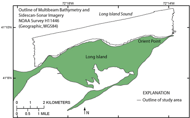
To release an outline of the multibeam-bathymetric and sidescan-sonar data generated during NOAA survey H11446 north of Orient Point, New York, in geographic.

How was the data set created?

  1. From what previous works were the data drawn?
    Information unavailable from original metadata. (source 1 of 1)
    The source information was incomplete and had to be modified to meet the standard. Assumed to be NOAA., unknown, The source information was incomplete and had to be modified to meet the standard..

    Type_of_Source_Media: DVD-ROM
    Source_Contribution:
    The original multibeam-bathymetric and sidescan-sonar data acquired during NOAA survey H11446 aboard the NOAA ship Thomas Jefferson.
  2. How were the data generated, processed, and modified?
    Date: 2010 (process 1 of 6)
    The geographic H11446 sidescan-sonar mosaic and multibeam bathymetry GeoTIFF were imported into the ArcView 3.3 GIS project view. These data were outlined using the available graphic tools then converted to an ArcView 3.3 polygon shapefile. Person who carried out this activity:
    Katherine McMullen
    U.S. Geological Survey
    Field and Laboratory Technician
    384 Woods Hole Road
    Woods Hole, MA

    508-548-8700 x2277 (voice)
    508-457-2310 (FAX)
    kmcmullen@usgs.gov
    Data sources used in this process:
    • h11446_sss1m_geo.tif
    • h11446_mb2m_geo.tif
    Data sources produced in this process:
    • h11446outline.shp
    Date: 2010 (process 2 of 6)
    ArcGIS 9.2 was used to define the projection of the ESRI shapefile and to create the .prj file. Person who carried out this activity:
    Katherine McMullen
    U.S. Geological Survey
    Field and Laboratory Technician
    384 Woods Hole Road
    Woods Hole, MA
    USA

    508-548-8700 x2277 (voice)
    508-457-2310 (FAX)
    kmcmullen@usgs.gov
    Data sources used in this process:
    • h11446outline.shp
    Data sources produced in this process:
    • h11446outline.prj
    Date: 17-Mar-2016 (process 3 of 6)
    Edits to the metadata were made to fix any errors that MP v 2.9.32 flagged. This is necessary to enable the metadata to be successfully harvested for various data catalogs. In some cases, this meant adding text "Information unavailable" or "Information unavailable from original metadata" for those required fields that were left blank. Other minor edits were probably performed (title, publisher, publication place, etc.). The source information was incomplete and had to be modified to meet the standard. The metadata date (but not the metadata creator) was edited to reflect the date of these changes. The metadata available from a harvester may supersede metadata bundled within a download file. Compare the metadata dates to determine which metadata file is most recent. Person who carried out this activity:
    U.S. Geological Survey
    Attn: VeeAnn A. Cross
    Marine Geologist
    384 Woods Hole Rd.
    Woods Hole, MA

    508-548-8700 x2251 (voice)
    508-457-2310 (FAX)
    vatnipp@usgs.gov
    Date: 20-Jul-2018 (process 4 of 6)
    USGS Thesaurus keywords added to the keyword section. Person who carried out this activity:
    U.S. Geological Survey
    Attn: VeeAnn A. Cross
    Marine Geologist
    384 Woods Hole Road
    Woods Hole, MA

    508-548-8700 x2251 (voice)
    508-457-2310 (FAX)
    vatnipp@usgs.gov
    Date: 18-Nov-2019 (process 5 of 6)
    Crossref DOI link was added as the first link in the metadata. Person who carried out this activity:
    U.S. Geological Survey
    Attn: VeeAnn A. Cross
    Marine Geologist
    384 Woods Hole Road
    Woods Hole, MA

    508-548-8700 x2251 (voice)
    508-457-2310 (FAX)
    vatnipp@usgs.gov
    Date: 08-Sep-2020 (process 6 of 6)
    Added keywords section with USGS persistent identifier as theme keyword. Person who carried out this activity:
    U.S. Geological Survey
    Attn: VeeAnn A. Cross
    Marine Geologist
    384 Woods Hole Road
    Woods Hole, MA

    508-548-8700 x2251 (voice)
    508-457-2310 (FAX)
    vatnipp@usgs.gov
  3. What similar or related data should the user be aware of?
    Schattgen, P. Tod, 2008, H11446: Descriptive Report H11446, National Ocean Survey, National Oceanic and Atmospheric Administration, Atlantic Hydrographic Branch, Norfolk, VA.

    Online Links:

    Poppe, L.J., McMullen, K.Y., Ackerman, S.D., Blackwood, D.S., Irwin, B.J., Schaer, J.D., Lewit, P.G., and Doran, E.F., 2010, Sea-Floor Geology and Character Offshore of Rocky Point, New York: Open-File Report 2010-1007, U.S. Geological Survey, Reston, VA.

    Online Links:

    Other_Citation_Details: DVD
    Poppe, L.J., DiGiacomo-Cohen, M.L., Doran, E.F., Smith, S.M., Stewart, H.F., and Forfinski, N.A., 2007, Geological interpretation and multibeam bathymetry of the sea floor in the vicinity of the Race, eastern Long Island Sound: Open-File Report 2007-1012, U.S. Geological Survey, Reston, VA.

    Online Links:

    Other_Citation_Details: DVD
    Poppe, L.J., Denny, J.F., Williams, S.J., Moser, M.S., Forfinski, N.A., Stewart, H.F., and Doran, E.F., 2007, The geology of Six Mile Reef, eastern Long Island Sound: Open-File Report 2007-1191, U.S. Geological Survey, Reston, VA.

    Online Links:

    Other_Citation_Details: DVD
    McMullen, K.Y., Poppe, L.J., Danforth, W.W., Blackwood, D.S., Schaer, J.D., Ostapenko, A.J., Glomb, K.A., and Doran, E.F., 2010, Surficial Geology of the Sea Floor in Long Island Sound Offshore of Plum Island, New York: Open-File Report 2010-1005, U.S. Geological Survey, Reston, VA.

    Online Links:

    Other_Citation_Details: CD-ROM

How reliable are the data; what problems remain in the data set?

  1. How well have the observations been checked?
  2. How accurate are the geographic locations?
    Horizontal positional accuracy is based on Differential GPS.
  3. How accurate are the heights or depths?
  4. Where are the gaps in the data? What is missing?
    This data layer shows the extent and locations of the areas surveyed during NOAA cruise H11446
  5. How consistent are the relationships among the observations, including topology?
    No additional checks for consistency were performed on this data.

How can someone get a copy of the data set?

Are there legal restrictions on access or use of the data?
Access_Constraints: None
Use_Constraints:
Public domain data are freely redistributable with proper metadata and source attribution. Please recognize the U.S. Geological Survey (USGS) as the originator of this information.
  1. Who distributes the data set? (Distributor 1 of 1)
    Larry Poppe
    U.S. Geological Survey
    Geologist
    384 Woods Hole Road
    Woods Hole, MA

    508-548-8700 x2314 (voice)
    508-457-2310 (FAX)
    lpoppe@usgs.gov
  2. What's the catalog number I need to order this data set? Downloadable Data
  3. What legal disclaimers am I supposed to read?
    Neither the U.S. Government, the Department of the Interior, nor the USGS, nor the National Oceanic and Atmospheric Administration (NOAA), nor any of their employees, contractors, or subcontractors, make any warranty, express or implied, nor assume any legal liability or responsibility for the accuracy, completeness, or usefulness of any information, apparatus, product, or process disclosed, nor represent that its use would not infringe on privately owned rights. The act of distribution shall not constitute any such warranty, and no responsibility is assumed by the USGS or NOAA in the use of these data or related materials. Any use of trade, product, or firm names is for descriptive purposes only and does not imply endorsement by the U.S. Government.
  4. How can I download or order the data?
  5. What hardware or software do I need in order to use the data set?
    These data are available in Environmental Systems Research Institute (ESRI) shapefile format. The user must have ArcGIS or ArcView 3.0 or greater software to read and process the data file. In lieu of ArcView or ArcGIS, the user may utilize another GIS application package capable of importing data. A free data viewer, ArcExplorer, capable of displaying the data is available from ESRI at www.esri.com. The user must have software capable of uncompressing archived zip files, such as Winzip or Pkware.

Who wrote the metadata?

Dates:
Last modified: 16-Nov-2021
Metadata author:
U.S. Geological Survey
Attn: Katherine McMullen
Field and Laboratory Technician
384 Woods Hole Road
Woods Hole, MA

508-548-8700 x2277 (voice)
508-457-2310 (FAX)
whsc_data_contact@usgs.gov
Contact_Instructions:
The metadata contact email address is a generic address in the event the metadata contact is no longer with the USGS or the email is otherwise invalid.
Metadata standard:
FGDC Content Standards for Digital Geospatial Metadata (FGDC-STD-001-1998)

This page is <https://cmgds.marine.usgs.gov/catalog/whcmsc/open_file_report/ofr2010-1100/h11446outline.shp.faq.html>
Generated by mp version 2.9.50 on Tue Nov 16 10:06:41 2021