Online Links:
Online Links:
| Range of values | |
|---|---|
| Minimum: | 41.1494 |
| Maximum: | 41.241783 |
| Units: | Decimal degrees |
| Resolution: | 0.000001 |
| Range of values | |
|---|---|
| Minimum: | -72.392433 |
| Maximum: | -72.149967 |
| Units: | Decimal degrees |
| Resolution: | 0.000001 |
| Range of values | |
|---|---|
| Minimum: | 26.7 |
| Maximum: | 86.1 |
| Units: | meters |
| Resolution: | 0.1 |
| Value | Definition |
|---|---|
| 0 | Depth in sediment in centimeters |
| Value | Definition |
|---|---|
| 2 | Depth in sediment in centimeters |
| Value | Definition |
|---|---|
| 5 | month of May |
| Range of values | |
|---|---|
| Minimum: | 24 |
| Maximum: | 26 |
| Units: | days |
| Resolution: | 1 |
| Value | Definition |
|---|---|
| 2010 | year |
| Range of values | |
|---|---|
| Minimum: | 39.2165 |
| Maximum: | 211.27 |
| Units: | grams |
| Resolution: | 0.0001 |
| Range of values | |
|---|---|
| Minimum: | 0 |
| Maximum: | 65.01 |
| Units: | percent |
| Resolution: | 0.01 |
| Range of values | |
|---|---|
| Minimum: | 34.29 |
| Maximum: | 98.22 |
| Units: | percent |
| Resolution: | 0.01 |
| Range of values | |
|---|---|
| Minimum: | 0.07 |
| Maximum: | 4.44 |
| Units: | percent |
| Resolution: | 0.01 |
| Range of values | |
|---|---|
| Minimum: | 0.02 |
| Maximum: | 1.93 |
| Units: | percent |
| Resolution: | 0.01 |
| Value | Definition |
|---|---|
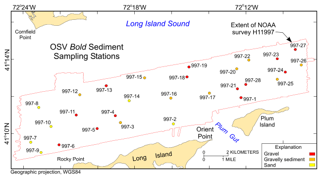
| SAND | Sediment whose main phase is less than 2 mm, but great greater than or equal to 0.062 mm |
| GRAVEL | Sediment whose main phase is >2 mm. Where samples were not taken, this sediment class was estimated from the bottom photography. |
| GRAVELLY SEDIMENT | Sediment whose main phase is >2 mm, but with significant other sediment |
| Range of values | |
|---|---|
| Minimum: | -3.34 |
| Maximum: | 1.64 |
| Units: | phi |
| Resolution: | 0.01 |
| Range of values | |
|---|---|
| Minimum: | -2.05 |
| Maximum: | 1.88 |
| Units: | phi |
| Resolution: | 0.01 |
| Range of values | |
|---|---|
| Minimum: | 0.96 |
| Maximum: | 3.22 |
| Units: | phi |
| Resolution: | 0.01 |
| Range of values | |
|---|---|
| Minimum: | -0.7 |
| Maximum: | 1.6 |
| Units: | no units |
| Resolution: | 0.01 |
| Range of values | |
|---|---|
| Minimum: | -0.83 |
| Maximum: | 19.03 |
| Units: | no units |
| Resolution: | 0.01 |
| Range of values | |
|---|---|
| Minimum: | 0 |
| Maximum: | 0.27 |
| Units: | percent |
| Resolution: | 0.01 |
| Range of values | |
|---|---|
| Minimum: | 0.01 |
| Maximum: | 0.59 |
| Units: | percent |
| Resolution: | 0.01 |
| Range of values | |
|---|---|
| Minimum: | 0.01 |
| Maximum: | 1.07 |
| Units: | percent |
| Resolution: | 0.01 |
| Range of values | |
|---|---|
| Minimum: | 0.02 |
| Maximum: | 1.29 |
| Units: | percent |
| Resolution: | 0.01 |
| Range of values | |
|---|---|
| Minimum: | 0.02 |
| Maximum: | 1.4 |
| Units: | percent |
| Resolution: | 0.01 |
| Range of values | |
|---|---|
| Minimum: | 0.01 |
| Maximum: | 0.97 |
| Units: | percent |
| Resolution: | 0.01 |
| Range of values | |
|---|---|
| Minimum: | 0.02 |
| Maximum: | 0.93 |
| Units: | percent |
| Resolution: | 0.01 |
| Range of values | |
|---|---|
| Minimum: | 0.12 |
| Maximum: | 7.2 |
| Units: | percent |
| Resolution: | 0.01 |
| Range of values | |
|---|---|
| Minimum: | 1.18 |
| Maximum: | 28.52 |
| Units: | percent |
| Resolution: | 0.01 |
| Range of values | |
|---|---|
| Minimum: | 10.87 |
| Maximum: | 59.77 |
| Units: | percent |
| Resolution: | 0.01 |
| Range of values | |
|---|---|
| Minimum: | 1.79 |
| Maximum: | 51.15 |
| Units: | percent |
| Resolution: | 0.01 |
| Range of values | |
|---|---|
| Minimum: | 1.36 |
| Maximum: | 20.03 |
| Units: | percent |
| Resolution: | 0.01 |
| Range of values | |
|---|---|
| Minimum: | 0 |
| Maximum: | 17.24 |
| Units: | percent |
| Resolution: | 0.01 |
| Range of values | |
|---|---|
| Minimum: | 0 |
| Maximum: | 19.48 |
| Units: | percent |
| Resolution: | 0.01 |
| Range of values | |
|---|---|
| Minimum: | 0 |
| Maximum: | 15.93 |
| Units: | percent |
| Resolution: | 0.01 |
| Range of values | |
|---|---|
| Minimum: | 0 |
| Maximum: | 44.47 |
| Units: | percent |
| Resolution: | 0.01 |
| Range of values | |
|---|---|
| Minimum: | 0 |
| Maximum: | 0 |
| Units: | percent |
| Resolution: | 0.01 |
The purpose of his data set is to release the locations, identifiers, grain-size data and(or) textural descriptions of surficial sediments collected at 28 stations on bathymetric data of the sea floor offshore in eastern Long Island Sound in Geographic, WGS84. These data can be used to provide information on surface geology and sedimentary processes.
Online Links:
Online Links:
Online Links:
Online Links:
Online Links:
Online Links:
Online Links:
Online Links:
Are there legal restrictions on access or use of the data?Access_Constraints: None
Use_Constraints:Public domain data from the U.S. Government are freely redistributable with proper metadata and source attribution. Please recognize the U.S. Geological Survey (USGS) as the source of this information.
Neither the U.S. Government, the Department of the Interior, nor the USGS, nor the National Oceanic and Atmospheric Administration (NOAA), nor the Connecticut Department of Environmental Protection (CT DEP) nor any of their employees, contractors, or subcontractors, make any warranty, express or implied, nor assume any legal liability or responsibility for the accuracy, completeness, or usefulness of any information, apparatus, product, or process disclosed, nor represent that its use would not infringe on privately owned rights. The act of distribution shall not constitute any such warranty, and no responsibility is assumed by the USGS, NOAA, or the CT DEP in the use of these data or related materials. Any use of trade, product, or firm names is for descriptive purposes only and does not imply endorsement by the U.S. Government.
| Data format: | A zip file containing the geospatial data, metadata describing the data set, and a browse graphic showing the data layer coverage and extent. The Excel (2003) and TEXT versions of the data are also available in the WinZip file. in format SHP (version ArcGIS 9.2) ESRI point shapefile Size: 0.052 |
|---|---|
| Network links: |
http://pubs.usgs.gov/of/2010/1150/data/sediment/2010_015_997seddata.zip http://pubs.usgs.gov/of/2010/1150/html/catalog.html |
| Media you can order: | DVD-ROM (Density 4.75 Gbytes) (format UDF) |
These data are available in Environmental Systems Research Institute (ESRI) shapefile format. The user must have ArcGIS or ArcView 3.0 or greater software to read and process the data file. In lieu of ArcView or ArcGIS, the user may utilize another GIS application package capable of importing data. A free data viewer, ArcExplorer, capable of displaying the data is available from ESRI at www.esri.com. The user must have software capable of uncompressing archived zip files, such as WinZip or Pkware. The Excel (2003) and TEXT versions of the data are also available in the WinZip file.
Neither the U.S. Government, the Department of the Interior, nor the USGS, nor the National Oceanic and Atmospheric Administration (NOAA), nor the Connecticut Department of Environmental Protection (CT DEP) nor any of their employees, contractors, or subcontractors, make any warranty, express or implied, nor assume any legal liability or responsibility for the accuracy, completeness, or usefulness of any information, apparatus, product, or process disclosed, nor represent that its use would not infringe on privately owned rights. The act of distribution shall not constitute any such warranty, and no responsibility is assumed by the USGS, NOAA, or the CT DEP in the use of these data or related materials. Any use of trade, product, or firm names is for descriptive purposes only and does not imply endorsement by the U.S. Government.
| Data format: | An Excel file containing navigation and grain-size analysis data. in format XLS Excel spreadsheet Size: 0.032 |
|---|---|
| Network links: |
http://pubs.usgs.gov/of/2010/1150/data/sediment/2010_015_997seddata.xls http://pubs.usgs.gov/of/2010/1150/html/catalog.html |
| Media you can order: | DVD-ROM (Density 4.75 Gbytes) (format UDF) |
These data are available in Microsoft Excel spreadsheet format. The user must have software capable of reading or importing the Excel-formatted data file.
Neither the U.S. Government, the Department of the Interior, nor the USGS, nor the National Oceanic and Atmospheric Administration (NOAA), nor the Connecticut Department of Environmental Protection (CT DEP) nor any of their employees, contractors, or subcontractors, make any warranty, express or implied, nor assume any legal liability or responsibility for the accuracy, completeness, or usefulness of any information, apparatus, product, or process disclosed, nor represent that its use would not infringe on privately owned rights. The act of distribution shall not constitute any such warranty, and no responsibility is assumed by the USGS, NOAA, or the CT DEP in the use of these data or related materials. Any use of trade, product, or firm names is for descriptive purposes only and does not imply endorsement by the U.S. Government.
| Data format: | First record contains field headings. Data fields are comma separated. in format ASCII text file Size: 0.008 |
|---|---|
| Network links: |
http://pubs.usgs.gov/of/2010/1150/data/sediment/2010_015_997seddata.txt http://pubs.usgs.gov/of/2010/1150/html/catalog.html |
| Media you can order: | DVD-ROM (Density 4.75 Gbytes) (format UDF) |
These data are available as a generic ASCII formatted data file. The user must have a software program capable of reading the comma-delimited data file.