CYM_250M_MER_NAD27.TIF - Cayman Trough GLORIA sidescan-sonar composite mosaic (MER, 250 m, Clarke 1866)

Metadata also available as - [Questions & Answers] - [Parseable text] - [XML]

Metadata:

Identification_Information:
Citation:
Citation_Information:
Originator: U.S. Geological Survey
Publication_Date: 2011
Title:
CYM_250M_MER_NAD27.TIF - Cayman Trough GLORIA sidescan-sonar composite mosaic (MER, 250 m, Clarke 1866)
Edition: 1.0
Geospatial_Data_Presentation_Form: remote-sensing image
Series_Information:
Series_Name: Open-File Report
Issue_Identification: 2010-1332
Publication_Information:
Publication_Place: Pacific Coastal and Marine Science Center, Menlo Park, CA
Publisher: U.S. Geological Survey, Coastal and Marine Geology Program
Online_Linkage: https://doi.org/10.3133/ofr20101332
Online_Linkage: https://pubs.usgs.gov/of/2010/1332/htmldocs/ct/ct_indexmap.html
Online_Linkage: Larger_Work_Citation:
Citation_Information:
Originator: Valerie F. Paskevich
Originator: Florence L. Wong
Originator: John J. O'Malley
Originator: Andrew J. Stevenson
Originator: Christina E. Gutmacher
Publication_Date: 2011
Title:
GLORIA Sidescan-Sonar Imagery for Parts of the U.S. Exclusive Economic Zone and Adjacent Areas
Edition: 1.0
Series_Information:
Series_Name: Open-File Report
Issue_Identification: 2010-1332
Publication_Information:
Publication_Place: Reston, VA
Publisher: U.S. Geological Survey
Online_Linkage: https://pubs.usgs.gov/of/2010/1332/
Description:
Abstract:
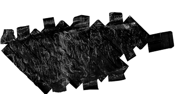
From October 22 to November 22, 1985 the U.S. Geological Survey (USGS) conducted a single to survey to ensonify the Cayman Trough. The survey took place over the coastal region of the spreading ridge and along one line to the eastern extremity of the Trough. As in earlier EEZ reconnaissance surveys, the USGS utilized the GLORIA (Geological LOng-Range Inclined Asdic) sidescan-sonar system to complete the geologic mapping. The collected GLORIA data were processed and digitally mosaicked to produce continuous imagery of the sea-floor. Two digital mosaics of a 2 degree by 2 degree area with a 50-meter pixel resolution were completed for the Cayman Trough south of the Cayman Islands.
Purpose:
This remote sensing image of the sea-floor is a reduced-resolution (250-meter) composite mosaic of the 2 mosaics created from the Cayman Trough GLORIA sidescan-sonar data.
Time_Period_of_Content:
Time_Period_Information:
Range_of_Dates/Times:
Beginning_Date: 19851022
Ending_Date: 19851102
Currentness_Reference: ground condition
Status:
Progress: Complete
Maintenance_and_Update_Frequency: None planned
Spatial_Domain:
Bounding_Coordinates:
West_Bounding_Coordinate: -83.150000
East_Bounding_Coordinate: -79.150295
North_Bounding_Coordinate: 19.500000
South_Bounding_Coordinate: 17.500933
Keywords:
Theme:
Theme_Keyword_Thesaurus: USGS Metadata Identifier
Theme_Keyword: USGS:af26183a-d3ce-47fe-86e7-0b87a6f4734d
Theme:
Theme_Keyword_Thesaurus: None
Theme_Keyword: U.S. Geological Survey
Theme_Keyword: USGS
Theme_Keyword: Coastal and Marine Geology Program
Theme_Keyword: CMGP
Theme_Keyword: Woods Hole Science Center
Theme_Keyword: WHSC
Theme_Keyword: Geological LOng-Range Inclined Asdic
Theme_Keyword: GLORIA
Theme_Keyword: GeoTIFF image
Theme_Keyword: grey scale image
Theme_Keyword: sidescan-sonar mosaic
Theme_Keyword: composite mosaic
Theme_Keyword: backscatter
Theme_Keyword: acoustic reflectivity
Theme_Keyword: marine geology
Theme_Keyword: 250-meter
Theme_Keyword: Albers Equal Area
Theme_Keyword: Exclusive Economic Zone
Theme_Keyword: EEZ
Theme_Keyword: WHSC serial number 85037
Theme_Keyword: WHSC cruise identifier FRNL87-3B
Theme_Keyword: Infobank identifier F-3B-85-CB
Theme:
Theme_Keyword_Thesaurus: ISO 19115 Topic Category
Theme_Keyword: oceans
Theme_Keyword: geoscientificInformation
Theme_Keyword: imageryBaseMapsEarthCover
Theme:
Theme_Keyword_Thesaurus:
NASA/Global Change Master Directory (GCMD) Earth Science Keywords, Version 6.0.0.0.0
Theme_Keyword: Oceans > Ocean Acoustics > Acoustic Reflectivity
Theme:
Theme_Keyword_Thesaurus: NASA/Global Change Master Directory (GCMD) Instrument Keywords
Theme_Keyword: ACOUSTIC RECEIVERS
Theme_Keyword: GLORIA > Geological Long-Range Inclined ASDIC
Theme_Keyword: SIDE-SCAN SONAR
Theme:
Theme_Keyword_Thesaurus: Data Categories for Marine Planning
Theme_Keyword: distributions
Theme_Keyword: physical habitats and geomorphology
Theme:
Theme_Keyword_Thesaurus: Marine Realms Information Bank (MRIB) Keywords
Theme_Keyword: seabed
Theme_Keyword: Exclusive Economic Zone (EEZ)
Theme_Keyword: sidescan sonar
Theme_Keyword: marine geophysics
Theme:
Theme_Keyword_Thesaurus: USGS Thesaurus
Theme_Keyword: sidescan sonar
Theme_Keyword: image mosaics
Theme_Keyword: marine geophysics
Theme_Keyword: sea-floor characteristics
Theme_Keyword: sea-floor acoustic reflectivity
Theme:
Theme_Keyword_Thesaurus: Coastal and Marine Ecological Classification Standard (CMECS)
Theme_Keyword: Marine Oceanic
Theme_Keyword: Continental/Island Slope
Theme_Keyword: Trench
Place:
Place_Keyword_Thesaurus: None
Place_Keyword: Caribbean Sea
Place_Keyword: Cayman Trough
Place:
Place_Keyword_Thesaurus: NASA/Global Change Master Directory (GCMD) Place Keywords
Place_Keyword: Ocean
Place_Keyword: Ocean > Atlantic Ocean
Place_Keyword: Ocean > Atlantic Ocean > North Atlantic Ocean
Place_Keyword: Ocean > Atlantic Ocean > North Atlantic Ocean > Caribbean Sea
Place_Keyword:
Ocean > Atlantic Ocean > North Atlantic Ocean > Caribbean Sea > Cayman Islands
Place:
Place_Keyword_Thesaurus: Coastal and Marine Ecological Classification Standard (CMECS)
Place_Keyword: Greater Antilles Ecoregion
Stratum:
Stratum_Keyword_Thesaurus: Coastal and Marine Ecological Classification Standard (CMECS)
Stratum_Keyword: Substrate
Access_Constraints: None
Use_Constraints:
Public domain data from the U.S. Government are freely redistributable with proper metadata and source attribution. Please recognize the U.S. Geological Survey as the originator of the dataset.
Point_of_Contact:
Contact_Information:
Contact_Organization_Primary:
Contact_Organization: U.S. Geological Survey
Contact_Person: Florence Wong
Contact_Position: Geologist
Contact_Address:
Address_Type: mailing and physical address
Address: 345 Middlefield Road MS 999
City: Menlo Park
State_or_Province: CA
Postal_Code: 94025
Country: USA
Contact_Voice_Telephone: (650) 329-5327
Contact_Facsimile_Telephone: (650) 329-5198
Contact_Electronic_Mail_Address: fwong@usgs.gov
Browse_Graphic:
Browse_Graphic_File_Name: Browse_Graphic_File_Description:
Thumbnail image showing an overview of the Cayman Trough GLORIA composite mosaic.
Browse_Graphic_File_Type: GIF
Browse_Graphic:
Browse_Graphic_File_Name: Browse_Graphic_File_Description:
Browse image showing an overview of the Cayman Trough GLORIA composite mosaic.
Browse_Graphic_File_Type: GIF
Data_Set_Credit:
Public domain data from the U.S. Government are freely redistributable with proper metadata and source attribution. The U.S. Geological Survey (USGS) must be referenced as the originator of the dataset in any future products or research derived from these data.
Native_Data_Set_Environment:
Microsoft Windows XP Version 5.1 (Build 2600) Service Pack 2; ESRI ArcCatalog 9.0.0.535
Cross_Reference:
Citation_Information:
Originator: J.V. Gardner (editor)
Originator: M.E. Field (editor)
Originator: D.C. Twichell (editor)
Publication_Date: 1996
Title: Geology of the United States Seafloor: The View from GLORIA
Edition: 1.0
Publication_Information:
Publication_Place: Cambridge, U.K.
Publisher: Cambridge University Press
Cross_Reference:
Citation_Information:
Originator: P.S. Chavez Jr.
Publication_Date: 1986
Title: Processing Techniques for Digital Sonar Images from GLORIA
Series_Information:
Series_Name: Photogrammetric Engineering and Remote Sensing
Issue_Identification: Vol. 52, No. 8, August 1986, p. 1133-1145
Publication_Information:
Publication_Place: Falls Church, VA 22046
Publisher: American Society for Photogrammetry and Remote Sensing
Cross_Reference:
Citation_Information:
Originator: P.S. Chavez Jr.
Publication_Date: 1984
Title: U.S. Geological Survey mini image processing system (MIPS)
Series_Information:
Series_Name: Open-File Report
Issue_Identification: 84-880
Publication_Information:
Publication_Place: Reston, VA
Publisher: U.S. Geological Survey
Online_Linkage: https://pubs.er.usgs.gov/publication/ofr84880
Data_Quality_Information:
Attribute_Accuracy:
Attribute_Accuracy_Report: There are no attributes associated with the GeoTIFF image.
Logical_Consistency_Report: not applicable
Completeness_Report:
All available imagery were used to create this mosaic. Data were acquired during a single cruise using the 6.5 kHz GLORIA sidescan-sonar system and a 45 km total swath width.
Positional_Accuracy:
Horizontal_Positional_Accuracy:
Horizontal_Positional_Accuracy_Report:
Primary navigational control for this survey was by Loran-C supplemented by satellite navigation. Accuracy of location of the navigation fixes is estimated to be better than 100 meters.
Lineage:
Source_Information:
Source_Citation:
Citation_Information:
Originator: U.S. Geological Survey
Publication_Date: unknown
Title: Not available from original metadata file
Type_of_Source_Media: disc
Source_Time_Period_of_Content:
Time_Period_Information:
Range_of_Dates/Times:
Beginning_Date: 19851022
Ending_Date: 19851102
Source_Currentness_Reference: ground condition
Source_Citation_Abbreviation: Cayman Trough GLORIA mosaics 1 and 2
Source_Contribution:
The 2 completed 50-meter mosaics were combined to create an Mercator (MER) projection, 250-meter composite overview.
Process_Step:
Process_Description:
An empty PCI database for the full extent of the Cayman Trough GLORIA was defined. The imagery database was defined with a Mercator (MER) projection at a resolution of 250-meters. Central longitude of 81d09'w and a central latitude of 18.5dn were selected with a Clarke 1866 spheroid (NAD27).
Process_Date: 20060501
Source_Produced_Citation_Abbreviation: cym_250m_mer_nad27.pix
Process_Contact:
Contact_Information:
Contact_Organization_Primary:
Contact_Organization: U.S. Geological Survey
Contact_Person: Valerie Paskevich
Contact_Position: Information Specialist / GIS Coordinator, retired
Contact_Address:
Address_Type: mailing and physical address
Address: 384 Woods Hole Road
City: Woods Hole
State_or_Province: MA
Postal_Code: 02543-1598
Country: USA
Contact_Voice_Telephone: (508) 548-8700
Contact_Facsimile_Telephone: (508) 457-2310
Process_Step:
Process_Description:
Using the PCI Geomatics tool GCPworks, the 2 individual 50-meter mosaics were combined to create a composite overview of the Cayman Trough GLORIA data at a resolution of 250-meters. The individual full-resolution GLORIA mosaics with the white flood-filled background were mosaiced together to create a single reduced-resolution composite mosaic for the Cayman Trough. Individual mosaics were "dropped" into the composite database. No rubber sheeting or geometric corrections were applied to the mosaics. However, some mosaics were radiometrically enhanced to reduce the effect of the individual square boundaries and produce a more uniform overview image. The individual 23 mosaics were combined using a bi-linear resampling mode to reduce noise and blockiness.
Source_Used_Citation_Abbreviation: cym_q01.tif
Source_Used_Citation_Abbreviation: cym_q02.tif
Source_Used_Citation_Abbreviation: cym_250m_mer_nad27.pix
Process_Date: 20060501
Source_Produced_Citation_Abbreviation: cym_250m_mer_nad27.pix
Process_Contact:
Contact_Information:
Contact_Organization_Primary:
Contact_Organization: U.S. Geological Survey
Contact_Person: Valerie Paskevich
Contact_Position: Information Specialist / GIS Coordinator, retired
Contact_Address:
Address_Type: mailing and physical address
Address: 384 Woods Hole Road
City: Woods Hole
State_or_Province: MA
Postal_Code: 02543-1598
Country: USA
Contact_Voice_Telephone: (508) 548-8700
Contact_Facsimile_Telephone: (508) 457-2310
Process_Step:
Process_Description:
The completed reduced 250-meter mosaic was exported from the PCI database as a GeoTIFF image with associated world file.
Source_Used_Citation_Abbreviation: cym_250m_mer_nad27.pix
Process_Date: 20060502
Source_Produced_Citation_Abbreviation: cym_250m_mer_nad27.tif
Source_Produced_Citation_Abbreviation: cym_250m_mer_nad27.tfw
Process_Contact:
Contact_Information:
Contact_Organization_Primary:
Contact_Organization: U.S. Geological Survey
Contact_Person: Valerie Paskevich
Contact_Position: Information Specialist / GIS Coordinator, retired
Contact_Address:
Address_Type: mailing and physical address
Address: 384 Woods Hole Road
City: Woods Hole
State_or_Province: MA
Postal_Code: 02543-1598
Country: USA
Contact_Voice_Telephone: (508) 548-8700
Contact_Facsimile_Telephone: (508) 457-2310
Process_Step:
Process_Description:
Keywords section of metadata optimized for discovery in USGS Coastal and Marine Geology Data Catalog.
Process_Date: 20170105
Process_Contact:
Contact_Information:
Contact_Organization_Primary:
Contact_Organization: U.S. Geological Survey
Contact_Person: Alan O. Allwardt
Contact_Position: Contractor -- Information Specialist
Contact_Address:
Address_Type: mailing and physical address
Address: 2885 Mission Street
City: Santa Cruz
State_or_Province: CA
Postal_Code: 95060
Contact_Voice_Telephone: 831-460-7551
Contact_Facsimile_Telephone: 831-427-4748
Contact_Electronic_Mail_Address: aallwardt@usgs.gov
Process_Step:
Process_Description:
Added keywords from Coastal and Marine Ecological Classification Standard (CMECS) to metadata.
Process_Date: 20180426
Process_Contact:
Contact_Information:
Contact_Organization_Primary:
Contact_Organization: U.S. Geological Survey
Contact_Person: Alan O. Allwardt
Contact_Position: Contractor -- Information Specialist
Contact_Address:
Address_Type: mailing and physical address
Address: 2885 Mission Street
City: Santa Cruz
State_or_Province: CA
Postal_Code: 95060
Contact_Voice_Telephone: 831-460-7551
Contact_Facsimile_Telephone: 831-427-4748
Contact_Electronic_Mail_Address: aallwardt@usgs.gov
Process_Step:
Process_Description:
Edits to the metadata were made to fix any errors that MP v 2.9.46 flagged. This is necessary to enable the metadata to be successfully harvested for various data catalogs. In some cases, this meant adding text "Information unavailable" or "Information unavailable from original metadata" for those required fields that were left blank. Other minor edits were probably performed (title, publisher, publication place, etc.). Added a landing page link as the first link in the identification section. Removed LIDAR bounding coordinates - an artifact of Esri and MP processing. Attempted to modify http to https where appropriate. Added a cross-reference online link. The source information was incomplete and had to be modified to meet the standard. The metadata date (but not the metadata creator) was edited to reflect the date of these changes. The metadata available from a harvester may supersede metadata bundled within a download file. Compare the metadata dates to determine which metadata file is most recent.
Process_Date: 20180503
Process_Contact:
Contact_Information:
Contact_Organization_Primary:
Contact_Organization: U.S. Geological Survey
Contact_Person: VeeAnn A. Cross
Contact_Position: Marine Geologist
Contact_Address:
Address_Type: Mailing and Physical
Address: 384 Woods Hole Road
City: Woods Hole
State_or_Province: MA
Postal_Code: 02543-1598
Contact_Voice_Telephone: 508-548-8700 x2251
Contact_Facsimile_Telephone: 508-457-2310
Contact_Electronic_Mail_Address: vatnipp@usgs.gov
Process_Step:
Process_Description: Crossref DOI link was added as the first link in the metadata.
Process_Date: 20191118
Process_Contact:
Contact_Information:
Contact_Organization_Primary:
Contact_Organization: U.S. Geological Survey
Contact_Person: VeeAnn A. Cross
Contact_Position: Marine Geologist
Contact_Address:
Address_Type: Mailing and Physical
Address: 384 Woods Hole Road
City: Woods Hole
State_or_Province: MA
Postal_Code: 02543-1598
Contact_Voice_Telephone: 508-548-8700 x2251
Contact_Facsimile_Telephone: 508-457-2310
Contact_Electronic_Mail_Address: vatnipp@usgs.gov
Process_Step:
Process_Description:
Added keywords section with USGS persistent identifier as theme keyword.
Process_Date: 20200908
Process_Contact:
Contact_Information:
Contact_Organization_Primary:
Contact_Organization: U.S. Geological Survey
Contact_Person: VeeAnn A. Cross
Contact_Position: Marine Geologist
Contact_Address:
Address_Type: Mailing and Physical
Address: 384 Woods Hole Road
City: Woods Hole
State_or_Province: MA
Postal_Code: 02543-1598
Contact_Voice_Telephone: 508-548-8700 x2251
Contact_Facsimile_Telephone: 508-457-2310
Contact_Electronic_Mail_Address: vatnipp@usgs.gov
Spatial_Data_Organization_Information:
Direct_Spatial_Reference_Method: Raster
Raster_Object_Information:
Raster_Object_Type: Pixel
Row_Count: 933
Column_Count: 1781
Vertical_Count: 1
Spatial_Reference_Information:
Horizontal_Coordinate_System_Definition:
Planar:
Map_Projection:
Map_Projection_Name: Mercator
Mercator:
Standard_Parallel: 0.000000
Longitude_of_Central_Meridian: 0.000000
False_Easting: 0.000000
False_Northing: 0.000000
Planar_Coordinate_Information:
Planar_Coordinate_Encoding_Method: row and column
Coordinate_Representation:
Abscissa_Resolution: 250.000000
Ordinate_Resolution: 250.000000
Planar_Distance_Units: meters
Geodetic_Model:
Horizontal_Datum_Name: D_Clarke_1866
Ellipsoid_Name: Clarke 1866
Semi-major_Axis: 6378206.400000
Denominator_of_Flattening_Ratio: 294.978698
Entity_and_Attribute_Information:
Overview_Description:
Entity_and_Attribute_Overview:
There are no attributes associated with a GeoTIFF image. Image pixel values contain acoustic reflectivity values normalized to an 8-bit data range (0-255). Low-backscatter is represented by dark tones (low values) and high-backscatter is represented by bright tones (high values). These data have NOT been radiometrically enhanced.
Entity_and_Attribute_Detail_Citation: U.S. Geological Survey
Distribution_Information:
Distributor:
Contact_Information:
Contact_Organization_Primary:
Contact_Organization: U.S. Geological Survey
Contact_Address:
Address_Type: mailing and physical address
Address: 384 Woods Hole Road
City: Woods Hole
State_or_Province: MA
Postal_Code: 02543-1598
Country: USA
Contact_Voice_Telephone: (508) 548-8700
Contact_Facsimile_Telephone: (508) 457-2310
Resource_Description: Downloadable Data
Distribution_Liability:
Neither the U.S. Government, the Department of the Interior, nor the USGS, nor any of their employees, contractors, or subcontractors, make any warranty, express or implied, nor assume any legal liability or responsibility for the accuracy, completeness, or usefulness of any information, apparatus, product, or process disclosed, nor represent that its use would not infringe on privately owned rights. The act of distribution shall not constitute any such warranty, and no responsibility is assumed by the USGS in the use of these data or related materials. Any use of trade, product, or firm names is for descriptive purposes only and does not imply endorsement by the U.S. Government.
Standard_Order_Process:
Digital_Form:
Digital_Transfer_Information:
Format_Name: TIFF
Format_Version_Number: Not available from original metadata
Format_Specification: GeoTIFF
Format_Information_Content:
A zip archive containing the GeoTIFF image, world file, browse graphics and metadata files.
File_Decompression_Technique: zip archive
Transfer_Size: .680
Digital_Transfer_Option:
Online_Option:
Computer_Contact_Information: Access_Instructions: Data are available for download on the World Wide Web (WWW).
Fees: None
Technical_Prerequisites:
The composite sidescan-sonar mosaic is available as a GeoTIFF image with accompanying world file and georeference report. To utilize this data, the user must have an image viewer, image processing or GIS software package capable of importing a GeoTIFF image. If the georeferencing information cannot be imported, the user may wish to view the georeference information contained in a separate file included in the zip file.
Distribution_Information:
Distributor:
Contact_Information:
Contact_Organization_Primary:
Contact_Organization: U.S. Geological Survey
Contact_Address:
Address_Type: mailing and physical address
Address: 345 Middlefield Road MS 999
City: Menlo Park
State_or_Province: CA
Postal_Code: 94025
Country: USA
Contact_Voice_Telephone: (650) 329-5078
Contact_Facsimile_Telephone: (650) 329-5190
Resource_Description: Downloadable Data
Distribution_Liability:
Neither the U.S. Government, the Department of the Interior, nor the USGS, nor any of their employees, contractors, or subcontractors, make any warranty, express or implied, nor assume any legal liability or responsibility for the accuracy, completeness, or usefulness of any information, apparatus, product, or process disclosed, nor represent that its use would not infringe on privately owned rights. The act of distribution shall not constitute any such warranty, and no responsibility is assumed by the USGS in the use of these data or related materials. Any use of trade, product, or firm names is for descriptive purposes only and does not imply endorsement by the U.S. Government.
Standard_Order_Process:
Digital_Form:
Digital_Transfer_Information:
Format_Name: TIFF
Format_Version_Number: Not available from original metadata
Format_Specification: GeoTIFF
Format_Information_Content:
A zip archive containing the GeoTIFF image, world file, browse graphics and metadata files.
File_Decompression_Technique: zip archive
Transfer_Size: .680
Digital_Transfer_Option:
Online_Option:
Computer_Contact_Information: Access_Instructions: Data are available for download on the World Wide Web (WWW).
Offline_Option:
Offline_Media: DVD-ROM
Recording_Capacity:
Recording_Density: 4.75
Recording_Density_Units: Gbytes
Recording_Format: UDF
Fees: None
Technical_Prerequisites:
The sidescan-sonar mosaic is available as a GeoTIFF image with accompanying world file and georeference report. To utilize this data, the user must have an image viewer, image processing or GIS software package capable of importing a GeoTIFF image. If the georeferencing information cannot be imported, the user may wish to obtain the georeference information contained in a separate file included in the zip file.
Metadata_Reference_Information:
Metadata_Date: 20211111
Metadata_Contact:
Contact_Information:
Contact_Organization_Primary:
Contact_Organization: U.S. Geological Survey
Contact_Person: Valerie Paskevich
Contact_Position: Information Specialist / GIS Coordinator, retired
Contact_Address:
Address_Type: mailing and physical address
Address: 384 Woods Hole Road
City: Woods Hole
State_or_Province: MA
Postal_Code: 02543-1598
Country: USA
Contact_Voice_Telephone: (508) 548-8700
Contact_Facsimile_Telephone: (508) 457-2310
Contact_Electronic_Mail_Address: whsc_data_contact@usgs.gov
Contact_Instructions:
The metadata contact email address is a generic address in the event the metadata contact is no longer with the USGS
Metadata_Standard_Name: FGDC Content Standards for Digital Geospatial Metadata
Metadata_Standard_Version: FGDC-STD-001-1998
Metadata_Time_Convention: local time
Metadata_Access_Constraints: None
Metadata_Use_Constraints: None

This page is <https://cmgds.marine.usgs.gov/catalog/whcmsc/open_file_report/ofr2010-1332/cym_250m_mer_nad27.tif.html>
Generated by mp version 2.9.50 on Mon Nov 15 14:24:38 2021