Citation:
Citation_Information:
Originator: U.S. Geological Survey
Publication_Date: 2011
Title:
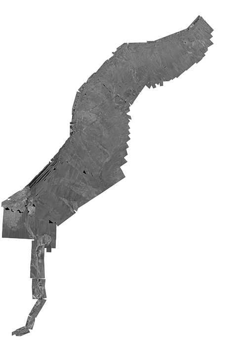
EC_250M_AEA_NAD27.TIF - U.S. Atlantic East Coast EEZ GLORIA sidescan-sonar composite mosaic (ACEA, 250 m, Clarke1866)
Edition: 1.0
Geospatial_Data_Presentation_Form: remote-sensing image
Series_Information:
Series_Name: Open-File Report
Issue_Identification: 2010-1332
Publication_Information:
Publication_Place: Pacific Coastal and Marine Science Center, Menlo Park, CA
Publisher: U.S. Geological Survey, Coastal and Marine Geology Program
Online_Linkage: https://doi.org/10.3133/ofr20101332
Online_Linkage: https://pubs.usgs.gov/of/2010/1332/htmldocs/ac/ac_indexmap.html
Online_Linkage:
Larger_Work_Citation:
Citation_Information:
Originator: Valerie F. Paskevich
Originator: Florence L. Wong
Originator: John J. O'Malley
Originator: Andrew J. Stevenson
Originator: Christina E. Gutmacher
Publication_Date: 2011
Title:
GLORIA Sidescan-Sonar Imagery for Parts of the U.S. Exclusive Economic Zone and Adjacent Areas
Edition: 1.0
Series_Information:
Series_Name: Open-File Report
Issue_Identification: 2010-1332
Publication_Information:
Publication_Place: Pacific Coastal and Marine Science Center, Menlo Park, CA
Publisher: U.S. Geological Survey, Coastal and Marine Geology Program
Online_Linkage: https://pubs.usgs.gov/of/2010/1332/
Description:
Abstract:
From February to May 1987 the U.S. Geological Survey (USGS) conducted five cruises to cover the U.S. Atlantic Continental Margin Exclusive Economic Zone (EEZ) seaward of the continental shelf edge, and from the Canadian border southward to the northern Blake Plateau off Florida. As in earlier EEZ reconnaissance surveys, the USGS utilized the GLORIA (Geological LOng-Range Inclined Asdic) sidescan-sonar system to complete the geologic mapping. The collected GLORIA data were processed and digitally mosaicked to produce continuous imagery of the sea-floor. A total of 23 digital mosaics of a 2 degree by 2 degree (or smaller) area with a 50-meter pixel resolution were completed for the U.S. Atlantic Continental Margin.
Purpose:
This remote sensing image of the sea-floor is a reduced-resolution (250-meter) composite mosaic of the 23 mosaics created from the U.S. Atlantic East coast GLORIA sidescan-sonar data.
Supplemental_Information:
Two of the mosaics contained in this composite mosaic have not been previously released. These mosaics, numbers 22 and 23, were obtained outside of the U.S. Exclusive Economic Zone and were not included in the original publications or data releases. They complete a southern extension of the original released mosaic and are located north of the Bahamas.
Time_Period_of_Content:
Time_Period_Information:
Range_of_Dates/Times:
Beginning_Date: 19870202
Ending_Date: 19870528
Currentness_Reference:
ground condition with the following date ranges: 19870202 to 19870227, 19870301 to 19870326, 19870328 to 19870425, 19870427 to 19870508, and 19870509 to 19870528
Status:
Progress: Complete
Maintenance_and_Update_Frequency: None planned
Spatial_Domain:
Bounding_Coordinates:
West_Bounding_Coordinate: -80.000000
East_Bounding_Coordinate: -63.028393
North_Bounding_Coordinate: 42.189539
South_Bounding_Coordinate: 24.500199
Keywords:
Theme:
Theme_Keyword_Thesaurus: USGS Metadata Identifier
Theme_Keyword: USGS:ad5a9795-82c4-4eba-8e9a-441d33f1ee51
Theme:
Theme_Keyword_Thesaurus: None
Theme_Keyword: U.S. Geological Survey
Theme_Keyword: USGS
Theme_Keyword: Coastal and Marine Geology Program
Theme_Keyword: CMGP
Theme_Keyword: Woods Hole Science Center
Theme_Keyword: WHSC
Theme_Keyword: Geological LOng-Range Inclined Asdic
Theme_Keyword: GLORIA
Theme_Keyword: GeoTIFF image
Theme_Keyword: grey scale image
Theme_Keyword: sidescan-sonar mosaic
Theme_Keyword: composite mosaic
Theme_Keyword: backscatter
Theme_Keyword: acoustic reflectivity
Theme_Keyword: marine geology
Theme_Keyword: 250-meter
Theme_Keyword: Albers Equal Area
Theme_Keyword: Exclusive Economic Zone
Theme_Keyword: EEZ
Theme_Keyword: WHSC serial number 87004
Theme_Keyword: WHSC serial number 87008
Theme_Keyword: WHSC serial number 87010
Theme_Keyword: WHSC serial number 87015
Theme_Keyword: WHSC serial number 87018
Theme_Keyword: WHSC cruise identifier FRNL87-1
Theme_Keyword: WHSC cruise identifier FRNL87-2
Theme_Keyword: WHSC cruise identifier FRNL87-3
Theme_Keyword: WHSC cruise identifier FRNL87-4
Theme_Keyword: WHSC cruise identifier FRNL87-5
Theme:
Theme_Keyword_Thesaurus: ISO 19115 Topic Category
Theme_Keyword: oceans
Theme_Keyword: geoscientificInformation
Theme_Keyword: imageryBaseMapsEarthCover
Theme:
Theme_Keyword_Thesaurus:
NASA/Global Change Master Directory (GCMD) Earth Science Keywords, Version 6.0.0.0.0
Theme_Keyword: Oceans > Ocean Acoustics > Acoustic Reflectivity
Theme:
Theme_Keyword_Thesaurus: NASA/Global Change Master Directory (GCMD) Instrument Keywords
Theme_Keyword: ACOUSTIC RECEIVERS
Theme_Keyword: GLORIA > Geological Long-Range Inclined ASDIC
Theme_Keyword: SIDE-SCAN SONAR
Theme:
Theme_Keyword_Thesaurus: Data Categories for Marine Planning
Theme_Keyword: distributions
Theme_Keyword: physical habitats and geomorphology
Theme:
Theme_Keyword_Thesaurus: Marine Realms Information Bank (MRIB) Keywords
Theme_Keyword: seabed
Theme_Keyword: Exclusive Economic Zone (EEZ)
Theme_Keyword: sidescan sonar
Theme_Keyword: marine geophysics
Theme:
Theme_Keyword_Thesaurus: USGS Thesaurus
Theme_Keyword: sidescan sonar
Theme_Keyword: image mosaics
Theme_Keyword: marine geophysics
Theme_Keyword: sea-floor characteristics
Theme_Keyword: sea-floor acoustic reflectivity
Theme:
Theme_Keyword_Thesaurus: Coastal and Marine Ecological Classification Standard (CMECS)
Theme_Keyword: Marine Oceanic
Theme_Keyword: Continental/Island Rise
Theme_Keyword: Continental/Island Slope
Theme_Keyword: Ocean Bank/Plateau
Place:
Place_Keyword_Thesaurus: None
Place_Keyword: U.S. East Coast
Place_Keyword: U.S. Atlantic Coast
Place_Keyword: Atlantic Ocean
Place_Keyword: Georges Bank
Place_Keyword: Mid Atlantic Region
Place_Keyword: Hudson Canyon
Place_Keyword: Veatch Canyon
Place_Keyword: Baltimore Canyon
Place_Keyword: Hendrickson Canyon
Place_Keyword: Norfolk Canyon
Place_Keyword: Carolina Slope and Rise
Place_Keyword: Charleston Bump
Place_Keyword: Hatteras Canyon
Place_Keyword: Blake Ridge
Place_Keyword: Blake Plateau
Place_Keyword: Blake Escarpment
Place_Keyword: Florida Slope
Place_Keyword: continental slope
Place_Keyword: continental rise
Place_Keyword: continental margin
Place_Keyword: continental shelf
Place:
Place_Keyword_Thesaurus: NASA/Global Change Master Directory (GCMD) Place Keywords
Place_Keyword: Ocean > Atlantic Ocean
Place_Keyword: Ocean > Atlantic Ocean > North Atlantic Ocean > Gulf Of Maine
Place_Keyword: Ocean > Atlantic Ocean > North Atlantic Ocean > Georges Bank
Place_Keyword: Ocean > Atlantic Ocean > North Atlantic Ocean > Caribbean Sea
Place_Keyword:
Ocean > Atlantic Ocean > North Atlantic Ocean > Caribbean Sea > Bahamas
Place:
Place_Keyword_Thesaurus: Coastal and Marine Ecological Classification Standard (CMECS)
Place_Keyword: Scotian Shelf Ecoregion
Place_Keyword: Gulf of Maine/Bay of Fundy Ecoregion
Place_Keyword: Virginian Ecoregion
Place_Keyword: Carolinian Ecoregion
Stratum:
Stratum_Keyword_Thesaurus: Coastal and Marine Ecological Classification Standard (CMECS)
Stratum_Keyword: Substrate
Access_Constraints: None
Use_Constraints:
Public domain data from the U.S. Government are freely redistributable with proper metadata and source attribution. Please recognize the U.S. Geological Survey as the originator of the dataset.
Point_of_Contact:
Contact_Information:
Contact_Organization_Primary:
Contact_Organization: U.S. Geological Survey
Contact_Person: Valerie Paskevich
Contact_Position: Information Specialist / GIS Coordinator, retired
Contact_Address:
Address_Type: mailing and physical address
Address: 384 Woods Hole Road
City: Woods Hole
State_or_Province: MA
Postal_Code: 02543-1598
Country: USA
Contact_Voice_Telephone: (508) 548-8700
Contact_Facsimile_Telephone: (508) 457-2310
Browse_Graphic:
Browse_Graphic_File_Name:
Browse_Graphic_File_Description:
Thumbnail image showing an overview of the U.S. Atlantic East Coast GLORIA composite mosaic.
Browse_Graphic_File_Type: GIF
Browse_Graphic:
Browse_Graphic_File_Name:
Browse_Graphic_File_Description:
Browse image showing an overview of the U.S. Atlantic East Coast GLORIA composite mosaic.
Browse_Graphic_File_Type: GIF
Data_Set_Credit:
Public domain data from the U.S. Government are freely redistributable with proper metadata and source attribution. The U.S. Geological Survey (USGS) must be referenced as the originator of the dataset in any future products or research derived from these data.
Native_Data_Set_Environment:
Microsoft Windows XP Version 5.1 (Build 2600) Service Pack 2; ESRI ArcCatalog 9.0.0.535
Cross_Reference:
Citation_Information:
Originator: EEZ-SCAN 87 Scientific Staff
Publication_Date: 1991
Title:
Atlas of the Exclusive Economic Zone, Atlantic continental margin
Series_Information:
Series_Name: Miscellaneous Investigation Series
Issue_Identification: I-2054
Publication_Information:
Publication_Place: Reston, VA
Publisher: U.S. Geological Survey
Other_Citation_Details: 174 p.
Cross_Reference:
Citation_Information:
Originator: J.V. Gardner (editor)
Originator: M.E. Field (editor)
Originator: D.C. Twichell (editor)
Publication_Date: 1996
Title: Geology of the United States Seafloor: The View from GLORIA
Edition: 1.0
Publication_Information:
Publication_Place: Cambridge, U.K.
Publisher: Cambridge University Press
Cross_Reference:
Citation_Information:
Originator: P.S. Chavez Jr.
Publication_Date: 1986
Title: Processing Techniques for Digital Sonar Images from GLORIA
Series_Information:
Series_Name: Photogrammetric Engineering and Remote Sensing
Issue_Identification: Vol. 52, No. 8, August 1986, p. 1133-1145
Publication_Information:
Publication_Place: Falls Church, VA 22046
Publisher: American Society for Photogrammetry and Remote Sensing
Cross_Reference:
Citation_Information:
Originator: P.S. Chavez Jr.
Publication_Date: 1984
Title: U.S. Geological Survey mini image processing system (MIPS)
Series_Information:
Series_Name: Open-File Report
Issue_Identification: 84-880
Publication_Information:
Publication_Place: Reston, VA
Publisher: U.S. Geological Survey
Online_Linkage: https://pubs.er.usgs.gov/publication/ofr84880
Cross_Reference:
Citation_Information:
Originator: V. Paskevich
Publication_Date: 1997
Title:
Digital Mosaics of the GLORIA Sidescan Sonar Data of the U.S. Atlantic East Coast
Series_Information:
Series_Name: Open-File Report
Issue_Identification: 97-853
Publication_Information:
Publication_Place: Woods Hole Science Center, Woods Hole, MA
Publisher: U.S. Geological Survey, Coastal and Marine Geology Program
Other_Citation_Details: 2 CD-ROM
Online_Linkage: https://pubs.er.usgs.gov/publication/ofr97853