Citation:
Citation_Information:
Originator: U.S. Geological Survey
Publication_Date: 2011
Title:
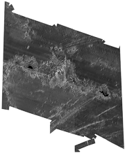
HW2_250M_LCC_WGS84.TIF - Hawaii II - Central Hawaiian Ridge U.S. EEZ GLORIA sidescan-sonar composite mosaic (LCC, 250 m, WGS84)
Edition: 1.0
Geospatial_Data_Presentation_Form: remote-sensing image
Series_Information:
Series_Name: Open-File Report
Issue_Identification: 2010-1332
Publication_Information:
Publication_Place: Pacific Coastal and Marine Science Center, Menlo Park, CA
Publisher: U.S. Geological Survey, Coastal and Marine Geology Program
Online_Linkage: https://doi.org/10.3133/ofr20101332
Online_Linkage:
Online_Linkage:
Larger_Work_Citation:
Citation_Information:
Originator: Valerie F. Paskevich
Originator: Florence L. Wong
Originator: John J. O'Malley
Originator: Andrew J. Stevenson
Originator: Christina E. Gutmacher
Publication_Date: 2011
Title:
GLORIA Sidescan-Sonar Imagery for Parts of the U.S. Exclusive Economic Zone and Adjacent Areas
Edition: 1.0
Series_Information:
Series_Name: Open-File Report
Issue_Identification: 2010-1332
Publication_Information:
Publication_Place: Reston, VA
Publisher: U.S. Geological Survey
Online_Linkage: https://pubs.usgs.gov/of/2010/1332/
Description:
Abstract:
In 1984, the U.S. Geological Survey (USGS), Office of Marine Geology, launched a program using the Geological LOng-Range Inclined Asdic (GLORIA) sidescan-sonar system to study the entire U.S. Exclusive Economic Zone (EEZ). From 1988 through 1991, as part of that program, the USGS and IOS (Institute of Oceanographic Sciences, U.K.) scientists conducted nine cruises within the U.S. EEZ off Hawaii. The surveys during that time period focused on the central Hawaiian region. The results of these surveys were 24 digital mosaics of approximately a 2 degree by 2 degree area with a 50-meter pixel resolution. As in earlier EEZ reconnaissance surveys, the USGS utilized the GLORIA (Geological LOng-Range Inclined Asdic) sidescan-sonar system to complete the geologic mapping. The collected GLORIA data were processed and digitally mosaicked to produce continuous imagery of the sea-floor.
Purpose:
This remote sensing image of the sea-floor is a reduced-resolution (250-meter) composite mosaic of the 24 mosaics created from the Hawaii II - Central Hawaiian Ridge U.S. EEZ GLORIA sidescan-sonar data.
Time_Period_of_Content:
Time_Period_Information:
Range_of_Dates/Times:
Beginning_Date: 19880928
Ending_Date: 19911029
Currentness_Reference:
ground condition with the following date ranges: 19880928 to 19881022, 19891103 to 19891126, 19891128 to 19891221, 19900103 to 19900128, 19900129 to 19900222, 19910105 to 19910128, 19910424 to 19910519, 19910521 to 19910615, and 19910927 to 19911029
Status:
Progress: Complete
Maintenance_and_Update_Frequency: None planned
Spatial_Domain:
Bounding_Coordinates:
West_Bounding_Coordinate: -173.391927
East_Bounding_Coordinate: -162.349828
North_Bounding_Coordinate: 30.640789
South_Bounding_Coordinate: 18.842192
Keywords:
Theme:
Theme_Keyword_Thesaurus: USGS Metadata Identifier
Theme_Keyword: USGS:54099483-f72e-4ee0-909b-b4bf2ec00586
Theme:
Theme_Keyword_Thesaurus: None
Theme_Keyword: U.S. Geological Survey
Theme_Keyword: USGS
Theme_Keyword: Coastal and Marine Geology Program
Theme_Keyword: CMGP
Theme_Keyword: Western Coastal and Marine Geology
Theme_Keyword: WCMG
Theme_Keyword: Geological LOng-Range Inclined Asdic
Theme_Keyword: GLORIA
Theme_Keyword: GeoTIFF image
Theme_Keyword: grey scale image
Theme_Keyword: backscatter
Theme_Keyword: acoustic reflectivity
Theme_Keyword: marine geology
Theme_Keyword: sidescan-sonar mosaic
Theme_Keyword: Exclusive Economic Zone
Theme_Keyword: EEZ
Theme_Keyword: Infobank identifier F-10-88-HW
Theme_Keyword: Infobank identifier F-12-89-HW
Theme_Keyword: Infobank identifier F-13-89-HW
Theme_Keyword: Infobank identifier F-1-90-HW
Theme_Keyword: Infobank identifier F-2-90-HW
Theme_Keyword: Infobank identifier F-1-91-CP
Theme_Keyword: Infobank identifier F-5-91-CP
Theme_Keyword: Infobank identifier F-6-91-CP
Theme_Keyword: Infobank identifier F-10-91-HW
Theme:
Theme_Keyword_Thesaurus: ISO 19115 Topic Category
Theme_Keyword: oceans
Theme_Keyword: geoscientificInformation
Theme_Keyword: imageryBaseMapsEarthCover
Theme:
Theme_Keyword_Thesaurus:
NASA/Global Change Master Directory (GCMD) Earth Science Keywords, Version 6.0.0.0.0
Theme_Keyword: Oceans > Ocean Acoustics > Acoustic Reflectivity
Theme:
Theme_Keyword_Thesaurus: NASA/Global Change Master Directory (GCMD) Instrument Keywords
Theme_Keyword: ACOUSTIC RECEIVERS
Theme_Keyword: GLORIA > Geological Long-Range Inclined ASDIC
Theme_Keyword: SIDE-SCAN SONAR
Theme:
Theme_Keyword_Thesaurus: Data Categories for Marine Planning
Theme_Keyword: distributions
Theme_Keyword: physical habitats and geomorphology
Theme:
Theme_Keyword_Thesaurus: Marine Realms Information Bank (MRIB) Keywords
Theme_Keyword: seabed
Theme_Keyword: Exclusive Economic Zone (EEZ)
Theme_Keyword: sidescan sonar
Theme_Keyword: marine geophysics
Theme:
Theme_Keyword_Thesaurus: USGS Thesaurus
Theme_Keyword: sidescan sonar
Theme_Keyword: image mosaics
Theme_Keyword: marine geophysics
Theme_Keyword: sea-floor characteristics
Theme_Keyword: sea-floor acoustic reflectivity
Theme:
Theme_Keyword_Thesaurus: Coastal and Marine Ecological Classification Standard (CMECS)
Theme_Keyword: Marine Oceanic
Theme_Keyword: Marine Basin Floor
Place:
Place_Keyword_Thesaurus: None
Place_Keyword: Hawaii
Place_Keyword: Hawaiian Islands
Place_Keyword: Hawaiian-Emperor Chain
Place_Keyword: Hawaiian Ridge
Place_Keyword: Hawaiian Arch
Place_Keyword: Hawaiian Trough
Place_Keyword: Midway Island
Place_Keyword: Gardner Pinnacles
Place_Keyword: Necker Ridge
Place_Keyword: Nihoa Ridge
Place_Keyword: Kauai Fracture Zone
Place_Keyword: Murray Fracture Zone
Place_Keyword: East Pacific Rise
Place_Keyword: Molokai Fracture Zone
Place_Keyword: Western Pacific Ocean
Place_Keyword: French Frigate Shoals
Place_Keyword: St. Rogatien Bank
Place_Keyword: Brooks Bank
Place_Keyword: Horizon Guyot
Place_Keyword: Kure Island
Place:
Place_Keyword_Thesaurus: NASA/Global Change Master Directory (GCMD) Place Keywords
Place_Keyword: Ocean > Pacific Ocean
Place_Keyword: Ocean > Pacific Ocean > Central Pacific Ocean
Place_Keyword:
Ocean > Pacific Ocean > Central Pacific Ocean > Hawaiian Islands
Place:
Place_Keyword_Thesaurus: Coastal and Marine Ecological Classification Standard (CMECS)
Place_Keyword: Hawaii Ecoregion
Stratum:
Stratum_Keyword_Thesaurus: Coastal and Marine Ecological Classification Standard (CMECS)
Stratum_Keyword: Substrate
Access_Constraints: None
Use_Constraints:
Public domain data from the U.S. Government are freely redistributable with proper metadata and source attribution. Please recognize the U.S. Geological Survey as the originator of the dataset.
Point_of_Contact:
Contact_Information:
Contact_Organization_Primary:
Contact_Organization: U.S. Geological Survey
Contact_Person: Florence Wong
Contact_Position: Geologist
Contact_Address:
Address_Type: mailing and physical address
Address: 345 Middlefield Road MS 999
City: Menlo Park
State_or_Province: CA
Postal_Code: 94025
Country: USA
Contact_Voice_Telephone: (650) 329-5327
Contact_Facsimile_Telephone: (650) 329-5198
Contact_Electronic_Mail_Address: [email protected]
Browse_Graphic:
Browse_Graphic_File_Name:
Browse_Graphic_File_Description:
Thumbnail image showing an overview of the Hawaii II - Central Hawaiian Ridge U.S. EEZ GLORIA composite mosaic.
Browse_Graphic_File_Type: GIF
Browse_Graphic:
Browse_Graphic_File_Name:
Browse_Graphic_File_Description:
Browse image showing an overview of the Hawaii II - Central Hawaiian Ridge U.S. EEZ GLORIA composite mosaic.
Browse_Graphic_File_Type: GIF
Data_Set_Credit:
The U.S. Geological Survey (USGS) must be referenced as the originator of the dataset in any future products or research derived from these data.
Native_Data_Set_Environment:
Microsoft Windows XP Version 5.1 (Build 2600) Service Pack 2; ESRI ArcCatalog 9.0.0.535
Cross_Reference:
Citation_Information:
Originator: P.S. Chavez Jr.
Publication_Date: 1986
Title: Processing Techniques for Digital Sonar Images from GLORIA
Series_Information:
Series_Name: Photogrammetric Engineering and Remote Sensing
Issue_Identification: Vol. 52, No. 8, August 1986, p. 1133-1145
Publication_Information:
Publication_Place: Falls Church, VA 22046
Publisher: American Society for Photogrammetry and Remote Sensing
Cross_Reference:
Citation_Information:
Originator: P.S. Chavez Jr.
Publication_Date: 1984
Title: U.S. Geological Survey mini image processing system (MIPS)
Series_Information:
Series_Name: Open-File Report
Issue_Identification: 84-880
Publication_Information:
Publication_Place: Reston, VA
Publisher: U.S. Geological Survey
Online_Linkage: https://pubs.er.usgs.gov/publication/ofr84880