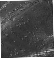
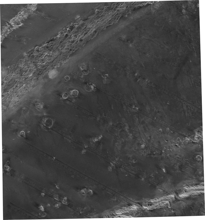
All available imagery were used to create this mosaic. Data were acquired during four cruises using the 6.5 kHz GLORIA sidescan-sonar system and a 45-km total swath width.
Source_Information:
Source_Citation:
Citation_Information:
Originator: U.S. Geological Survey
Publication_Date: unknown
Title: Not available from original metadata file
Type_of_Source_Media: digital tape media
Source_Time_Period_of_Content:
Time_Period_Information:
Range_of_Dates/Times:
Beginning_Date: 19880928
Ending_Date: 19911029
Source_Currentness_Reference:
ground condition with the following date ranges: 19880928 to 19881022, 19891103 to 19891126, 19891128 to 19891221, 19900103 to 19900128, 19900129 to 19900222, 19910105 to 19910128, 19910424 to 19910519, 19910521 to 19910615, and 19910927 to 19911029
Source_Citation_Abbreviation: GLORIA pass data
Source_Contribution:
GLORIA data were logged to magnetic tape in 6-hour portions referred to as "passes". Each completed pass contained a maximum 720 "lines" of data at the usual 30-second pulse repetition rate. Each line consisted of a 1024 byte record that contained the port and starboard returns from a single ping as well as header information. These "passes" contained geometric and radiometric distortions which had to be corrected before they could be digitally mosaicked.
Process_Step:
Process_Description:
The GLORIA "passes" necessary to complete the mosaic were retrieved from magnetic tape. Navigation data were merged into the individual "passes" to update the header information with depth and location coordinates.
Source_Used_Citation_Abbreviation: GLORIA pass data
Process_Date: Unknown
Source_Produced_Citation_Abbreviation: "pass".mrg
Process_Contact:
Contact_Information:
Contact_Organization_Primary:
Contact_Organization: U.S. Geological Survey
Contact_Address:
Address_Type: mailing and physical address
Address: 345 Middlefield Road MS 999
City: Menlo Park
State_or_Province: CA
Postal_Code: 94025
Country: USA
Contact_Voice_Telephone: (650) 329-5078
Contact_Facsimile_Telephone: (650) 329-5190
Process_Step:
Process_Description:
Slant-Range correction, the first of two geometric corrections, were applied to the "passes". Slant-range error is mislocation of pixels in the cross-track direction compared to their proper location on a map. This error occurs due to the way that the sidescan-sonar senses distance to a target. After the slant-range correction has been made, the across-track location of targets is accurate.
Source_Used_Citation_Abbreviation: "pass".mrg
Process_Date: Unknown
Source_Produced_Citation_Abbreviation: "pass".slr
Process_Contact:
Contact_Information:
Contact_Organization_Primary:
Contact_Organization: U.S. Geological Survey
Contact_Address:
Address_Type: mailing and physical address
Address: 345 Middlefield Road MS 999
City: Menlo Park
State_or_Province: CA
Postal_Code: 94025
Country: USA
Contact_Voice_Telephone: (650) 329-5078
Contact_Facsimile_Telephone: (650) 329-5190
Process_Step:
Process_Description:
A series of radiometric corrections were then applied to the "passes". The first enhancement was used to correct for shading problems that occur in the across-track direction and are a function of attenuation in range distance and transmitter power build-up.
Source_Used_Citation_Abbreviation: "pass".slr
Process_Date: Unknown
Source_Produced_Citation_Abbreviation: "pass".shd
Process_Contact:
Contact_Information:
Contact_Organization_Primary:
Contact_Organization: U.S. Geological Survey
Contact_Address:
Address_Type: mailing and physical address
Address: 345 Middlefield Road MS 999
City: Menlo Park
State_or_Province: CA
Postal_Code: 94025
Country: USA
Contact_Voice_Telephone: (650) 329-5078
Contact_Facsimile_Telephone: (650) 329-5190
Process_Step:
Process_Description:
The next radiometric enhancement was applied in a two-part filtering process to remove the striped noise that can be found in side-scan sonar image in the across-track direction. The noise was removed by applying two separate boxcar filters: (1) a high-pass filter that will contain the high-frequency component of the image without the noise; and (2) a low-pass filter that will include the low-frequency component of the image without the noise.
Source_Used_Citation_Abbreviation: "pass".shd
Process_Date: Unknown
Source_Produced_Citation_Abbreviation: "pass".hpf
Source_Produced_Citation_Abbreviation: "pass".lpf
Process_Contact:
Contact_Information:
Contact_Organization_Primary:
Contact_Organization: U.S. Geological Survey
Contact_Address:
Address_Type: mailing and physical address
Address: 345 Middlefield Road MS 999
City: Menlo Park
State_or_Province: CA
Postal_Code: 94025
Country: USA
Contact_Voice_Telephone: (650) 329-5078
Contact_Facsimile_Telephone: (650) 329-5190
Process_Step:
Process_Description:
The two filtered images were combined to recreate an image similar to the original but without the noise.
Source_Used_Citation_Abbreviation: "pass".lpf
Source_Used_Citation_Abbreviation: "pass".hpf
Process_Date: Unknown
Source_Produced_Citation_Abbreviation: "pass".wco
Process_Contact:
Contact_Information:
Contact_Organization_Primary:
Contact_Organization: U.S. Geological Survey
Contact_Address:
Address_Type: mailing and physical address
Address: 345 Middlefield Road MS 999
City: Menlo Park
State_or_Province: CA
Postal_Code: 94025
Country: USA
Contact_Voice_Telephone: (650) 329-5078
Contact_Facsimile_Telephone: (650) 329-5190
Process_Step:
Process_Description:
The second geometric correction, aspect-ratio distortion, was applied to the "passes". The aspect-ratio distortion was removed by using the navigation data to compute the distance traveled by the ship. Given the distance traveled, the number of pixels (each representing 50 m) required along the particular segment was calculated. The original pixels were then duplicated the appropriate number of times to fill the space with 50-meter pixels and thus achieve a 1:1 ratio between along-track and across-track distances. The practice of duplication to create a square 50-meter pixel size was followed so that information in the across-track direction would not have to be omitted.
Source_Used_Citation_Abbreviation: "pass".wco
Process_Date: Unknown
Source_Produced_Citation_Abbreviation: "pass".vel
Process_Contact:
Contact_Information:
Contact_Organization_Primary:
Contact_Organization: U.S. Geological Survey
Contact_Address:
Address_Type: mailing and physical address
Address: 345 Middlefield Road MS 999
City: Menlo Park
State_or_Province: CA
Postal_Code: 94025
Country: USA
Contact_Voice_Telephone: (650) 329-5078
Contact_Facsimile_Telephone: (650) 329-5190
Process_Step:
Process_Description:
A third radiometric enhancement, a 2 by 2 low-pass filter for smoothing the images, was applied to the "passes". Because the delta velocity correction typically stretches the imagery 1:2.5 times, a 2 by 2 low-pass filter is applied to the image to smooth and reduce the blockiness that results from the line duplication. The 2 by 2 low-pass filter smoothes out the blockiness introduced into the image without over smoothing and blurring the image.
Source_Used_Citation_Abbreviation: "pass".vel
Process_Date: Unknown
Source_Produced_Citation_Abbreviation: "pass".2b2
Process_Contact:
Contact_Information:
Contact_Organization_Primary:
Contact_Organization: U.S. Geological Survey
Contact_Address:
Address_Type: mailing and physical address
Address: 345 Middlefield Road MS 999
City: Menlo Park
State_or_Province: CA
Postal_Code: 94025
Country: USA
Contact_Voice_Telephone: (650) 329-5078
Contact_Facsimile_Telephone: (650) 329-5190
Process_Step:
Process_Description:
A final radiometric enhancement was applied to the image to reduce the halo effect that occurs in the along-track direction near the nadir. This enhancement involved creating two separate images from the input image. The images were produced as a result of 151-line by 31- sample high-pass filter plus a 151-line by 401-sample low-pass filter. The two resultant images were then digitally combined to produce an image similar to the original but without the halo effect.
Source_Used_Citation_Abbreviation: "pass".2b2
Process_Date: Unknown
Source_Produced_Citation_Abbreviation: "pass".hal
Process_Contact:
Contact_Information:
Contact_Organization_Primary:
Contact_Organization: U.S. Geological Survey
Contact_Address:
Address_Type: mailing and physical address
Address: 345 Middlefield Road MS 999
City: Menlo Park
State_or_Province: CA
Postal_Code: 94025
Country: USA
Contact_Voice_Telephone: (650) 329-5078
Contact_Facsimile_Telephone: (650) 329-5190
Process_Step:
Process_Description:
After the geometric and radiometric corrections were applied, the data were ready for the digital mosaicking. The necessary segments of processed data, each representing about 6-hours of data acquisition, were spliced end-to-end to make continuous swaths for portions of the tracklines where the ship's heading remained generally constant and passed through the mosaic area. The segments were tone-matched by adjusting the average brightness to minimize the tonal contrast at the seams where they were joined. Latitude, longitude, and heading were determined along the trackline of each continuous segment of data at the start, end, and two intermediate points. These four control points, with eight additional points that were computed for the edges of the image segment, were used to position the segment within the map grid.
Source_Used_Citation_Abbreviation: "pass".hal
Process_Date: Unknown
Source_Produced_Citation_Abbreviation: h2_q37_line"n"
Process_Contact:
Contact_Information:
Contact_Organization_Primary:
Contact_Organization: U.S. Geological Survey
Contact_Address:
Address_Type: mailing and physical address
Address: 345 Middlefield Road MS 999
City: Menlo Park
State_or_Province: CA
Postal_Code: 94025
Country: USA
Contact_Voice_Telephone: (650) 329-5078
Contact_Facsimile_Telephone: (650) 329-5190
Process_Step:
Process_Description:
When the individual trackline segments had been georeferenced, the next step was to digitally stencil the segments to remove unwanted data (i.e. noise). Interactively, a line was drawn on a video display outlining the portion of each image segment to be retained while comparing it to adjacent segments. Then all pixels outside the area enclosed by the line were converted to zero values, thereby retaining only that portion of the image desired. Finally, each stenciled segment was mosaicked to adjacent segments, sequentially building the composite map. In this way a digital file was created with the desired map projection for each imagery sheet (mosaic).
Source_Used_Citation_Abbreviation: h2_q37_line"n"
Process_Date: Unknown
Source_Produced_Citation_Abbreviation: h2q37.bin
Process_Contact:
Contact_Information:
Contact_Organization_Primary:
Contact_Organization: U.S. Geological Survey
Contact_Address:
Address_Type: mailing and physical address
Address: 345 Middlefield Road MS 999
City: Menlo Park
State_or_Province: CA
Postal_Code: 94025
Country: USA
Contact_Voice_Telephone: (650) 329-5078
Contact_Facsimile_Telephone: (650) 329-5190
Process_Step:
Process_Description:
The completed mosaic, in a raw binary format, was converted to an ArcInfo BIL format file.
Source_Used_Citation_Abbreviation: h2q37.bin
Process_Date: Unknown
Source_Produced_Citation_Abbreviation: h2q37.bil
Process_Contact:
Contact_Information:
Contact_Organization_Primary:
Contact_Organization: U.S. Geological Survey
Contact_Address:
Address_Type: mailing and physical address
Address: 345 Middlefield Road MS 999
City: Menlo Park
State_or_Province: CA
Postal_Code: 94025
Country: USA
Contact_Voice_Telephone: (650) 329-5078
Contact_Facsimile_Telephone: (650) 329-5190
Process_Step:
Process_Description:
The binary image files of the GLORIA mosaics were imported into an ArcMap map allowing the images to be georeferenced.
Source_Used_Citation_Abbreviation: h2q37.bil
Process_Date: 200710
Source_Produced_Citation_Abbreviation: h2q37.bil
Process_Contact:
Contact_Information:
Contact_Organization_Primary:
Contact_Organization: U.S. Geological Survey
Contact_Person: John O'Malley
Contact_Position: GIS Specialist
Contact_Address:
Address_Type: mailing and physical address
Address: 384 Woods Hole Road
City: Woods Hole
State_or_Province: MA
Postal_Code: 02543-1598
Country: USA
Contact_Voice_Telephone: (508) 548-8700 x2340
Contact_Facsimile_Telephone: (508) 457-2310
Contact_Electronic_Mail_Address: [email protected]
Process_Step:
Process_Description:
The GLORIA image was exported from the bil file format to a GeoTIFF image file format.
Source_Used_Citation_Abbreviation: h2q37.bil
Process_Date: 200710
Source_Produced_Citation_Abbreviation: hw2_q37.tif
Process_Contact:
Contact_Information:
Contact_Organization_Primary:
Contact_Organization: U.S. Geological Survey
Contact_Person: John O'Malley
Contact_Position: GIS Specialist
Contact_Address:
Address_Type: mailing and physical address
Address: 384 Woods Hole Road
City: Woods Hole
State_or_Province: MA
Postal_Code: 02543-1598
Country: USA
Contact_Voice_Telephone: (508) 548-8700 x2340
Contact_Facsimile_Telephone: (508) 457-2310
Contact_Electronic_Mail_Address: [email protected]
Process_Step:
Process_Description:
The image was modified to flood-fill the background 0 (black) data value to 255 (white). After modification, the header portion of the image was updated to restore the georeferencing information. An ESRI world file was generated using GeoTIFF tools, listgeo.exe.
Source_Used_Citation_Abbreviation: hw2_q37.tif
Process_Date: 200710
Source_Produced_Citation_Abbreviation: hw2_q37.tif
Source_Produced_Citation_Abbreviation: hw2_q37.tfw
Process_Contact:
Contact_Information:
Contact_Organization_Primary:
Contact_Organization: U.S. Geological Survey
Contact_Person: John O'Malley
Contact_Position: GIS Specialist
Contact_Address:
Address_Type: mailing and physical address
Address: 384 Woods Hole Road
City: Woods Hole
State_or_Province: MA
Postal_Code: 02543-1598
Country: USA
Contact_Voice_Telephone: (508) 548-8700 x2340
Contact_Facsimile_Telephone: (508) 457-2310
Contact_Electronic_Mail_Address: [email protected]
Process_Step:
Process_Description:
Keywords section of metadata optimized for discovery in USGS Coastal and Marine Geology Data Catalog.
Process_Date: 20170105
Process_Contact:
Contact_Information:
Contact_Organization_Primary:
Contact_Organization: U.S. Geological Survey
Contact_Person: Alan O. Allwardt
Contact_Position: Contractor -- Information Specialist
Contact_Address:
Address_Type: mailing and physical address
Address: 2885 Mission Street
City: Santa Cruz
State_or_Province: CA
Postal_Code: 95060
Contact_Voice_Telephone: 831-460-7551
Contact_Facsimile_Telephone: 831-427-4748
Contact_Electronic_Mail_Address: [email protected]
Process_Step:
Process_Description:
Added keywords from Coastal and Marine Ecological Classification Standard (CMECS) to metadata.
Process_Date: 20180426
Process_Contact:
Contact_Information:
Contact_Organization_Primary:
Contact_Organization: U.S. Geological Survey
Contact_Person: Alan O. Allwardt
Contact_Position: Contractor -- Information Specialist
Contact_Address:
Address_Type: mailing and physical address
Address: 2885 Mission Street
City: Santa Cruz
State_or_Province: CA
Postal_Code: 95060
Contact_Voice_Telephone: 831-460-7551
Contact_Facsimile_Telephone: 831-427-4748
Contact_Electronic_Mail_Address: [email protected]
Process_Step:
Process_Description:
Edits to the metadata were made to fix any errors that MP v 2.9.46 flagged. This is necessary to enable the metadata to be successfully harvested for various data catalogs. In some cases, this meant adding text "Information unavailable" or "Information unavailable from original metadata" for those required fields that were left blank. Other minor edits were probably performed (title, publisher, publication place, etc.). Added a landing page link as the first link in the identification section. Fixed the date format in the time period of content. Removed LIDAR bounding coordinates - an artifact of Esri and MP processing. Attempted to modify http to https where appropriate. Added a cross-reference online link. The source information was incomplete and had to be modified to meet the standard. The metadata date (but not the metadata creator) was edited to reflect the date of these changes. The metadata available from a harvester may supersede metadata bundled within a download file. Compare the metadata dates to determine which metadata file is most recent.
Process_Date: 20180507
Process_Contact:
Contact_Information:
Contact_Organization_Primary:
Contact_Organization: U.S. Geological Survey
Contact_Person: VeeAnn A. Cross
Contact_Position: Marine Geologist
Contact_Address:
Address_Type: Mailing and Physical
Address: 384 Woods Hole Road
City: Woods Hole
State_or_Province: MA
Postal_Code: 02543-1598
Contact_Voice_Telephone: 508-548-8700 x2251
Contact_Facsimile_Telephone: 508-457-2310
Contact_Electronic_Mail_Address: [email protected]
Process_Step:
Process_Description: Crossref DOI link was added as the first link in the metadata.
Process_Date: 20191118
Process_Contact:
Contact_Information:
Contact_Organization_Primary:
Contact_Organization: U.S. Geological Survey
Contact_Person: VeeAnn A. Cross
Contact_Position: Marine Geologist
Contact_Address:
Address_Type: Mailing and Physical
Address: 384 Woods Hole Road
City: Woods Hole
State_or_Province: MA
Postal_Code: 02543-1598
Contact_Voice_Telephone: 508-548-8700 x2251
Contact_Facsimile_Telephone: 508-457-2310
Contact_Electronic_Mail_Address: [email protected]
Process_Step:
Process_Description:
Added keywords section with USGS persistent identifier as theme keyword.
Process_Date: 20200908
Process_Contact:
Contact_Information:
Contact_Organization_Primary:
Contact_Organization: U.S. Geological Survey
Contact_Person: VeeAnn A. Cross
Contact_Position: Marine Geologist
Contact_Address:
Address_Type: Mailing and Physical
Address: 384 Woods Hole Road
City: Woods Hole
State_or_Province: MA
Postal_Code: 02543-1598
Contact_Voice_Telephone: 508-548-8700 x2251
Contact_Facsimile_Telephone: 508-457-2310
Contact_Electronic_Mail_Address: [email protected]