Interpretation of Sedimentary Environments from National Oceanic and Atmospheric Administration (NOAA) Survey H11922 West of Gay Head, Massachusetts, in Eastern Rhode Island Sound (H11922_SEDENV.SHP, Geographic, WGS84)

Metadata also available as - [Questions & Answers] - [Parseable text] - [XML]

Metadata:

Identification_Information:
Citation:
Citation_Information:
Originator: Larry Poppe
Publication_Date: 2011
Title:
Interpretation of Sedimentary Environments from National Oceanic and Atmospheric Administration (NOAA) Survey H11922 West of Gay Head, Massachusetts, in Eastern Rhode Island Sound (H11922_SEDENV.SHP, Geographic, WGS84)
Edition: 1.0
Geospatial_Data_Presentation_Form: vector digital data
Series_Information:
Series_Name: Open-File Report
Issue_Identification: 2011-1004
Publication_Information:
Publication_Place: Woods Hole Coastal and Marine Science Center, Woods Hole, MA
Publisher: U.S. Geological Survey, Coastal and Marine Geology Program
Online_Linkage: https://doi.org/10.3133/ofr20111004
Online_Linkage: http://pubs.usgs.gov/of/2011/1004/data/sedenv/h11922_sedenv.zip
Online_Linkage: http://pubs.usgs.gov/of/2011/1004/html/catalog.html
Larger_Work_Citation:
Citation_Information:
Originator: L.J. Poppe
Originator: K.Y. McMullen
Originator: S.D. Ackerman
Originator: D.S. Blackwood
Originator: B.J. Irwin
Originator: J.D. Schaer
Originator: M.R. Forrest
Publication_Date: 2011
Title:
Sea-Floor Geology and Character of Eastern Rhode Island Sound West of Gay Head, Massachusetts
Edition: 1.0
Geospatial_Data_Presentation_Form: GIS data report
Series_Information:
Series_Name: Open-File Report
Issue_Identification: 2011-1004
Publication_Information:
Publication_Place: Reston, VA
Publisher: U.S. Geological Survey
Other_Citation_Details: 1 DVD-ROM
Online_Linkage: http://pubs.usgs.gov/of/2011/1004/
Description:
Abstract:
The U.S. Geological Survey (USGS), in cooperation with the National Oceanic and Atmospheric Administration (NOAA), is producing detailed geologic maps of the coastal sea floor. Bathymetry, originally collected by NOAA for charting purposes, provides a fundamental framework for research and management activities off southern New England, shows the composition and terrain of the seabed, and provides information on sediment transport and benthic habitat. During July-August 2008 NOAA completed hydrographic survey H11922 west of Gay Head, Massachusetts, in Rhode Island Sound and during July and September 2010 bottom photographs and surficial sediment data were acquired as part of ground-truth reconnaissance surveys of this area. Interpretations were derived from the multibeam echo-sounder data and the ground-truth data used to verify them. For more information on the ground-truth surveys see http://quashnet.er.usgs.gov/data/2010/10033/ and http://quashnet.er.usgs.gov/data/2010/10005/
Purpose:
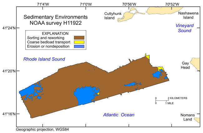
To release an interpretation of sedimentary environments based on bathymetry data collected during NOAA survey H11922 and sediment samples and bottom photography collected during USGS surveys 2010-033-FA and 2010-005-FA of the sea floor off Gay Head, Massachusetts, in eastern Rhode Island Sound, in a geographic, WGS84 coordinate system. These data can be used to provide information on surface geology and sedimentary processes.
Time_Period_of_Content:
Time_Period_Information:
Multiple_Dates/Times:
Single_Date/Time:
Calendar_Date: 20100721
Single_Date/Time:
Calendar_Date: 20100912
Currentness_Reference:
Ground condition, however, calendar date is for the bottom samples and photography. Multibeam bathymetry used in the interpretation were collected during 20080716 to 20080822.
Status:
Progress: Complete
Maintenance_and_Update_Frequency: None planned
Spatial_Domain:
Bounding_Coordinates:
West_Bounding_Coordinate: -71.103124
East_Bounding_Coordinate: -70.870066
North_Bounding_Coordinate: 41.360214
South_Bounding_Coordinate: 41.259755
Keywords:
Theme:
Theme_Keyword_Thesaurus: USGS Metadata Identifier
Theme_Keyword: USGS:42e6cdc4-8363-433a-b201-3e23c54c04af
Theme:
Theme_Keyword_Thesaurus: None
Theme_Keyword: U.S. Geological Survey
Theme_Keyword: USGS
Theme_Keyword: Woods Hole Coastal and Marine Science Center
Theme_Keyword: Sedimentary Environments
Theme_Keyword: Coastal and Marine Geology Program
Theme_Keyword: CMGP
Theme_Keyword: WHCMSC
Theme_Keyword: NOAA Survey H11922
Theme_Keyword: H11922
Theme_Keyword: National Oceanic and Atmospheric Administration
Theme_Keyword: NOAA
Theme_Keyword: Field Activity Number 2010-033-FA
Theme_Keyword: ESRI Shapefile
Theme_Keyword: Erosion or Nondeposition
Theme_Keyword: Coarse Bedload Transport
Theme_Keyword: Open-File Report 2011-1004
Theme_Keyword: OFR 2011-1004
Theme_Keyword: polygon
Theme_Keyword: Field Activity Number 2010-005-FA
Theme_Keyword: interpretation
Theme_Keyword: Sorting and Reworking
Theme_Keyword: Info Bank ID R-33-10-RI
Theme_Keyword: Info Bank ID U-5-10-BZ
Theme:
Theme_Keyword_Thesaurus: ISO 19115 Topic Category
Theme_Keyword: geoscientificInformation
Theme_Keyword: oceans
Theme_Keyword: location
Theme:
Theme_Keyword_Thesaurus: USGS Thesaurus
Theme_Keyword: scientific interpretation
Theme_Keyword: sea-floor characteristics
Theme_Keyword: ocean processes
Theme_Keyword: sediment transport
Theme_Keyword: geospatial datasets
Place:
Place_Keyword_Thesaurus: None
Place_Keyword: Massachusetts
Place_Keyword: Rhode Island
Place_Keyword: Martha's Vineyard
Place_Keyword: U.S. East Coast
Place_Keyword: United States
Place_Keyword: North America
Place_Keyword: Atlantic Ocean
Place_Keyword: Rhode Island Sound
Place_Keyword: Cuttyhunk Island
Place_Keyword: Nomans Land
Place_Keyword: Gay Head
Place_Keyword: Aquinnah
Access_Constraints: None
Use_Constraints:
The interpretation was completed at map scales between 1:4,000 and 1:8,500, but is not intended for use at map scales smaller than 1:10,000. Public domain data from the U.S. Government are freely redistributable with proper metadata and source attribution. Please recognize the U.S. Geological Survey (USGS) as the source of this information.
Point_of_Contact:
Contact_Information:
Contact_Person_Primary:
Contact_Person: Larry Poppe
Contact_Organization: U.S. Geological Survey
Contact_Position: Geologist
Contact_Address:
Address_Type: mailing and physical address
Address: 384 Woods Hole Road
City: Woods Hole
State_or_Province: MA
Postal_Code: 02543
Country: USA
Contact_Voice_Telephone: 508-548-8700 x2314
Contact_Facsimile_Telephone: 508-457-2310
Contact_Electronic_Mail_Address: lpoppe@usgs.gov
Browse_Graphic:
Browse_Graphic_File_Name: http://pubs.usgs.gov/of/2011/1004/data/sedenv/h11922_sedenv.gif
Browse_Graphic_File_Description:
Thumbnail image showing the interpreted sedimentary environments within NOAA survey H11922
Browse_Graphic_File_Type: GIF
Native_Data_Set_Environment:
Microsoft Windows XP Version 5.1 (Build 2600) Service Pack 3; ESRI ArcCatalog 9.2.6.1500
Cross_Reference:
Citation_Information:
Originator: Knebel, H.J.
Originator: Poppe, L.J.
Publication_Date: 2000
Title:
Sea-floor environments within Long Island Sound: a regional overview
Edition: 1.0
Geospatial_Data_Presentation_Form: journal article
Series_Information:
Series_Name: Journal of Coastal Research
Issue_Identification: v. 16, no. 3, p. 533-550
Publication_Information:
Publication_Place: Lawrence, KS
Publisher: Coastal Education & Research Foundation
Cross_Reference:
Citation_Information:
Originator: Poppe, L.J.
Originator: Ackerman, S.D.
Originator: Foster, D.S.
Originator: Blackwood, D.S.
Originator: Butman, B.
Originator: Moser, M.S.
Originator: Stewart, H.F.
Publication_Date: 2007
Title:
Sea-floor character and surface processes in the vicinity of Quicks Hole, Elizabeth Islands, Massachusetts
Edition: 1.0
Geospatial_Data_Presentation_Form: GIS data report
Series_Information:
Series_Name: Open-File Report
Issue_Identification: 2006-1357
Publication_Information:
Publication_Place: Reston, VA
Publisher: U.S. Geological Survey
Other_Citation_Details: 1 DVD-ROM
Online_Linkage: http://pubs.usgs.gov/of/2006/1357/
Cross_Reference:
Citation_Information:
Originator: Poppe, L.J.
Originator: Ackerman, S.D.
Originator: Foster, D.S.
Originator: Blackwood, D.S.
Originator: Williams, S.J.
Originator: Moser, M.S.
Originator: Stewart, H.F.
Originator: Glomb, K.A.
Publication_Date: 2007
Title:
Sea-floor character and sedimentary processes of Great Round Shoal Channel, offshore Massachusetts
Edition: 1.0
Geospatial_Data_Presentation_Form: GIS data report
Series_Information:
Series_Name: Open-File Report
Issue_Identification: 2007-1138
Publication_Information:
Publication_Place: Reston, VA
Publisher: U.S. Geological Survey
Other_Citation_Details: 1 DVD-ROM
Online_Linkage: http://pubs.usgs.gov/of/2007/1138/
Cross_Reference:
Citation_Information:
Originator: Poppe, L.J.
Originator: McMullen, K.Y.
Originator: Foster, D.S.
Originator: Blackwood, D.S.
Originator: Williams, S.J.
Originator: Ackerman, S.D.
Originator: Barnum, S.R.
Originator: Brennan, R.T.
Publication_Date: 2008
Title:
Sea-floor character and sedimentary processes in the vicinity of Woods Hole, Massachusetts
Edition: 1.0
Geospatial_Data_Presentation_Form: GIS data report
Series_Information:
Series_Name: Open-File Report
Issue_Identification: 2008-1004
Publication_Information:
Publication_Place: Reston, VA
Publisher: U.S. Geological Survey
Other_Citation_Details: 1 DVD-ROM
Online_Linkage: http://pubs.usgs.gov/of/2008/1004/
Cross_Reference:
Citation_Information:
Originator: Poppe, L.J.
Originator: McMullen, K.Y.
Originator: Foster, D.S.
Originator: Blackwood, D.S.
Originator: Williams, S.J.
Originator: Ackerman, S.D.
Originator: Moser, M.S.
Originator: Glomb, K.A.
Publication_Date: 2010
Title:
Geological interpretation of the seafloor offshore of Edgartown, Massachusetts
Edition: 1.0
Geospatial_Data_Presentation_Form: GIS data report
Series_Information:
Series_Name: Open-File Report
Issue_Identification: 2009-1001
Publication_Information:
Publication_Place: Reston, VA
Publisher: U.S. Geological Survey
Other_Citation_Details: 1 DVD-ROM
Online_Linkage: http://pubs.usgs.gov/of/2009/1001/
Cross_Reference:
Citation_Information:
Originator: McMullen, K.Y.
Originator: Poppe, L.J.
Originator: Soderberg, N.K.
Publication_Date: 2009
Title:
Digital seismic-reflection data from Eastern Rhode Island Sound, 1975-1980
Edition: 1.0
Geospatial_Data_Presentation_Form: GIS data report
Series_Information:
Series_Name: Open-File Report
Issue_Identification: 2009-1003
Publication_Information:
Publication_Place: Reston, VA
Publisher: U.S. Geological Survey
Other_Citation_Details: 2 DVD-ROMs
Online_Linkage: http://pubs.usgs.gov/of/2009/1003/
Cross_Reference:
Citation_Information:
Originator: McMullen, K.Y.
Originator: Poppe, L.J.
Originator: Denny, J.F.
Originator: Haupt, T.A.
Originator: Crocker, J.M.
Publication_Date: 2008
Title:
Sidescan-sonar imagery and surficial geologic interpretations of the sea floor in central Rhode Island Sound
Edition: 1.0
Geospatial_Data_Presentation_Form: GIS data report
Series_Information:
Series_Name: Open-File Report
Issue_Identification: 2007-1366
Publication_Information:
Publication_Place: Reston, VA
Publisher: U.S. Geological Survey
Other_Citation_Details: 1 DVD-ROM
Online_Linkage: http://pubs.usgs.gov/of/2007/1366/
Cross_Reference:
Citation_Information:
Originator: P. Tod Schattgen
Publication_Date: 2008
Title: H11922
Edition: 1.0
Geospatial_Data_Presentation_Form: document
Series_Information:
Series_Name: Descriptive Report
Issue_Identification: H11922
Publication_Information:
Publication_Place: Atlantic Hydrographic Branch, Norfolk, VA
Publisher:
National Ocean Survey, National Oceanic and Atmospheric Administration
Online_Linkage:
Cross_Reference:
Citation_Information:
Originator: McMullen, K.Y.
Originator: Poppe, L.J.
Originator: Ackerman, S.D.
Originator: Blackwood, D.S.
Originator: Schaer, J.D.
Originator: Nadeau, M.A.
Originator: Wood, D.A.
Publication_Date: 2011
Title:
Surficial geology of the sea floor in central Rhode Island Sound, southeast of Point Judith, Rhode Island
Edition: 1.0
Geospatial_Data_Presentation_Form: GIS data report
Series_Information:
Series_Name: Open-File Report
Issue_Identification: 2011-1005
Publication_Information:
Publication_Place: Reston, VA
Publisher: U.S. Geological Survey
Other_Citation_Details: 1 DVD-ROM
Online_Linkage: http://pubs.usgs.gov/of/2011/1005/
Data_Quality_Information:
Logical_Consistency_Report:
No additional checks for consistency were performed on this data.
Completeness_Report:
All collected data with the study area were processed and used to identify conditions and processes that allowed us to interpret the prevalent sedimentary environments on the sea floor and to produce this dataset.
Positional_Accuracy:
Horizontal_Positional_Accuracy:
Horizontal_Positional_Accuracy_Report:
Navigation of the underlying data on which the interpretation is based was by differential GPS. Interpretation is good to 1:10,000.
Lineage:
Source_Information:
Source_Citation:
Citation_Information:
Originator:
The source information specified in the metadata appears to actually cover two datasets. One from NOAA and one from USGS.
Publication_Date: unknown
Title: Information unavailable from original metadata.
Type_of_Source_Media: DVD-ROM
Source_Time_Period_of_Content:
Time_Period_Information:
Range_of_Dates/Times:
Beginning_Date: 20100721
Ending_Date: 20100912
Source_Currentness_Reference:
Ground condition, however, calendar date is for the bottom samples and photography. Multibeam bathymetry data used in the interpretation were collected during 20080716 to 20080822.
Source_Citation_Abbreviation: Information unavailable from original metadata.
Source_Contribution:
The original acoustic data acquired during NOAA survey H11922 aboard the NOAA ship Thomas Jefferson and the portion of the sediment samples and bottom photography collected during USGS surveys 2010-033-FA and 2010-005-FA that fall within the study area. Historical grain-size data used in the interpretation are from Poppe and others (1998).
Process_Step:
Process_Description:
The geographic GeoTIFF image of the multibeam bathymetry data from survey H11922 and the point data layer from grain-size analyses of sediments collected from this survey area were imported into the ArcView 3.3 GIS project view. Sedimentary environments were interpreted based on geomorphology and relief in the bathymetry, on the bottom photography and on the new and historical textural analyses. The individually interpreted environments (erosion or nondeposition, coarse bedload transport, and sorting and reworking) were outlined using the available graphic tools then converted to an ESRI shapefile using ArcView 3.3. Polygons were were traced at a scale of 1:4,000, but union and subtraction edits were conducted at 1:5,000 to 1:8,500 scales. Therefore, use of this interpretation datalayer is not recommended at scales of less than 1:10,000.
Source_Used_Citation_Abbreviation: h11922_2mmb_geo.tif
Source_Used_Citation_Abbreviation: 2010_033_922seddata.shp
Source_Used_Citation_Abbreviation: 2010_033_922botphotos.shp
Process_Date: 2010
Source_Produced_Citation_Abbreviation: h11922_sedenv.shp
Process_Contact:
Contact_Information:
Contact_Person_Primary:
Contact_Person: Larry Poppe
Contact_Organization: U.S. Geological Survey
Contact_Position: Geologist
Contact_Address:
Address_Type: mailing and physical address
Address: 384 Woods Hole Road
City: Woods Hole
State_or_Province: MA
Postal_Code: 02543
Country: USA
Contact_Voice_Telephone: 508-548-8700 x2314
Contact_Facsimile_Telephone: 508-457-2310
Contact_Electronic_Mail_Address: lpoppe@usgs.gov
Process_Step:
Process_Description:
ArcGIS 9.2 was used to define the projection of the ESRI shapefile as geographic WGS84 and to create the .prj file using the ArcToolbox Define Projection tool.
Source_Used_Citation_Abbreviation: h11922_sedenv.shp
Process_Date: 2010
Source_Produced_Citation_Abbreviation: h11922_sedenv.prj
Process_Contact:
Contact_Information:
Contact_Person_Primary:
Contact_Person: Larry Poppe
Contact_Organization: U.S. Geological Survey
Contact_Position: Geologist
Contact_Address:
Address_Type: mailing and physical address
Address: 384 Woods Hole Road
City: Woods Hole
State_or_Province: MA
Postal_Code: 02543
Country: USA
Contact_Voice_Telephone: 508-548-8700 x2314
Contact_Facsimile_Telephone: 508-457-2310
Contact_Electronic_Mail_Address: lpoppe@usgs.gov
Process_Step:
Process_Description:
Edits to the metadata were made to fix any errors that MP v 2.9.32 flagged. This is necessary to enable the metadata to be successfully harvested for various data catalogs. In some cases, this meant adding text "Information unavailable" or "Information unavailable from original metadata" for those required fields that were left blank. Other minor edits were probably performed (title, publisher, publication place, etc.). The source information was incomplete and had to be modified to meet the standard. The metadata date (but not the metadata creator) was edited to reflect the date of these changes. The metadata available from a harvester may supersede metadata bundled within a download file. Compare the metadata dates to determine which metadata file is most recent.
Process_Date: 20160524
Process_Contact:
Contact_Information:
Contact_Organization_Primary:
Contact_Organization: U.S. Geological Survey
Contact_Person: VeeAnn A. Cross
Contact_Position: Marine Geologist
Contact_Address:
Address_Type: mailing and physical address
Address: 384 Woods Hole Rd.
City: Woods Hole
State_or_Province: MA
Postal_Code: 02543
Contact_Voice_Telephone: 508-548-8700 x2251
Contact_Facsimile_Telephone: 508-457-2310
Contact_Electronic_Mail_Address: vatnipp@usgs.gov
Process_Step:
Process_Description: USGS Thesaurus keywords added to the keyword section.
Process_Date: 20180720
Process_Contact:
Contact_Information:
Contact_Organization_Primary:
Contact_Organization: U.S. Geological Survey
Contact_Person: VeeAnn A. Cross
Contact_Position: Marine Geologist
Contact_Address:
Address_Type: Mailing and Physical
Address: 384 Woods Hole Road
City: Woods Hole
State_or_Province: MA
Postal_Code: 02543-1598
Contact_Voice_Telephone: 508-548-8700 x2251
Contact_Facsimile_Telephone: 508-457-2310
Contact_Electronic_Mail_Address: vatnipp@usgs.gov
Process_Step:
Process_Description: Crossref DOI link was added as the first link in the metadata.
Process_Date: 20191118
Process_Contact:
Contact_Information:
Contact_Organization_Primary:
Contact_Organization: U.S. Geological Survey
Contact_Person: VeeAnn A. Cross
Contact_Position: Marine Geologist
Contact_Address:
Address_Type: Mailing and Physical
Address: 384 Woods Hole Road
City: Woods Hole
State_or_Province: MA
Postal_Code: 02543-1598
Contact_Voice_Telephone: 508-548-8700 x2251
Contact_Facsimile_Telephone: 508-457-2310
Contact_Electronic_Mail_Address: vatnipp@usgs.gov
Process_Step:
Process_Description:
Added keywords section with USGS persistent identifier as theme keyword.
Process_Date: 20200908
Process_Contact:
Contact_Information:
Contact_Organization_Primary:
Contact_Organization: U.S. Geological Survey
Contact_Person: VeeAnn A. Cross
Contact_Position: Marine Geologist
Contact_Address:
Address_Type: Mailing and Physical
Address: 384 Woods Hole Road
City: Woods Hole
State_or_Province: MA
Postal_Code: 02543-1598
Contact_Voice_Telephone: 508-548-8700 x2251
Contact_Facsimile_Telephone: 508-457-2310
Contact_Electronic_Mail_Address: vatnipp@usgs.gov
Spatial_Data_Organization_Information:
Direct_Spatial_Reference_Method: Vector
Point_and_Vector_Object_Information:
SDTS_Terms_Description:
SDTS_Point_and_Vector_Object_Type: G-polygon
Point_and_Vector_Object_Count: 45
Spatial_Reference_Information:
Horizontal_Coordinate_System_Definition:
Geographic:
Latitude_Resolution: 0.000001
Longitude_Resolution: 0.000001
Geographic_Coordinate_Units: Decimal degrees
Geodetic_Model:
Horizontal_Datum_Name: D_WGS_1984
Ellipsoid_Name: WGS_1984
Semi-major_Axis: 6378137.000000
Denominator_of_Flattening_Ratio: 298.257224
Entity_and_Attribute_Information:
Detailed_Description:
Entity_Type:
Entity_Type_Label: h11922_sedenv
Entity_Type_Definition: Shapefile Attribute Table
Entity_Type_Definition_Source: ESRI
Attribute:
Attribute_Label: FID
Attribute_Definition: Internal feature number.
Attribute_Definition_Source: ESRI
Attribute_Domain_Values:
Unrepresentable_Domain:
Sequential unique whole numbers that are automatically generated.
Attribute:
Attribute_Label: Shape
Attribute_Definition: Feature geometry.
Attribute_Definition_Source: ESRI
Attribute_Domain_Values:
Unrepresentable_Domain: Coordinates defining the features.
Attribute:
Attribute_Label: ID
Attribute_Definition: Internal feature number.
Attribute_Definition_Source: ESRI
Attribute_Domain_Values:
Unrepresentable_Domain: Information unavailable from original metadata.
Attribute:
Attribute_Label: SEDENV
Attribute_Definition: Interpreted sea floor sedimentary environment
Attribute_Definition_Source: Scientist
Attribute_Domain_Values:
Enumerated_Domain:
Enumerated_Domain_Value: Erosion or Nondeposition
Enumerated_Domain_Value_Definition:
High-energy environment within which sea-floor sediments are either removed or do not accumulate
Enumerated_Domain_Value_Definition_Source: Scientist
Attribute_Domain_Values:
Enumerated_Domain:
Enumerated_Domain_Value: Coarse Bedload Transport
Enumerated_Domain_Value_Definition:
Environment within which sea-floor sand and pea gravel sized sediments are transported. Bedforms are typically present.
Enumerated_Domain_Value_Definition_Source: Scientist
Attribute_Domain_Values:
Enumerated_Domain:
Enumerated_Domain_Value: Sorting and Reworking
Enumerated_Domain_Value_Definition:
Environment within which sea-floor sand and mud-sized sediments are being separated
Enumerated_Domain_Value_Definition_Source: Scientist
Overview_Description:
Entity_and_Attribute_Overview:
Shapefile containing interpretations of sedimentary environments on the seafloor offshore in eastern Rhode Island Sound. Shapefile shows distribution of environments characterized by erosion or nondeposition, coarse bedload transport, and sorting and reworking.
Entity_and_Attribute_Detail_Citation: U.S. Geological Survey
Distribution_Information:
Distributor:
Contact_Information:
Contact_Person_Primary:
Contact_Person: Larry Poppe
Contact_Organization: U.S. Geological Survey
Contact_Position: Geologist
Contact_Address:
Address_Type: mailing and physical address
Address: 384 Woods Hole Road
City: Woods Hole
State_or_Province: MA
Postal_Code: 02543
Country: USA
Contact_Voice_Telephone: 508-548-8700 x2314
Contact_Facsimile_Telephone: 508-457-2310
Contact_Electronic_Mail_Address: lpoppe@usgs.gov
Resource_Description: Downloadable Data
Distribution_Liability:
Neither the U.S. Government, the Department of the Interior, nor the USGS, nor the National Oceanic and Atmospheric Administration (NOAA), nor any of their employees, contractors, or subcontractors, make any warranty, express or implied, nor assume any legal liability or responsibility for the accuracy, completeness, or usefulness of any information, apparatus, product, or process disclosed, nor represent that its use would not infringe on privately owned rights. The act of distribution shall not constitute any such warranty, and no responsibility is assumed by the USGS or NOAA in the use of these data or related materials. Any use of trade, product, or firm names is for descriptive purposes only and does not imply endorsement by the U.S. Government.
Standard_Order_Process:
Digital_Form:
Digital_Transfer_Information:
Format_Name: SHP
Format_Version_Number: ArcView 3.3
Format_Specification: ESRI polygon shapefile
Format_Information_Content:
A zip file containing the geospatial data, metadata, and browse graphic.
File_Decompression_Technique: zip archive
Transfer_Size: 0.112
Digital_Transfer_Option:
Online_Option:
Computer_Contact_Information: Access_Instructions: data are downloadable via the World Wide Web (WWW)
Offline_Option:
Offline_Media: DVD-ROM
Recording_Capacity:
Recording_Density: 4.7
Recording_Density_Units: Gbytes
Recording_Format: UDF
Fees: None
Technical_Prerequisites:
The user must be capable of uncompressing WinZip files. Also, these data are available in Environmental Systems Research Institute (ESRI) shapefile format. The user must have ArcGIS or ArcView 3.0 or greater software to read and process the data file. In lieu of ArcView or ArcGIS, the user may utilize another GIS application package capable of importing data. A free data viewer, ArcExplorer, capable of displaying the data is available from ESRI at www.esri.com.
Available_Time_Period:
Time_Period_Information:
Single_Date/Time:
Calendar_Date: 2011
Metadata_Reference_Information:
Metadata_Date: 20211116
Metadata_Contact:
Contact_Information:
Contact_Organization_Primary:
Contact_Organization: U.S. Geological Survey
Contact_Person: Larry Poppe
Contact_Position: Geologist
Contact_Address:
Address_Type: mailing and physical address
Address: 384 Woods Hole Road
City: Woods Hole
State_or_Province: MA
Postal_Code: 02543
Country: USA
Contact_Voice_Telephone: 508-548-8700 x2314
Contact_Facsimile_Telephone: 508-457-2310
Contact_Electronic_Mail_Address: whsc_data_contact@usgs.gov
Contact_Instructions:
The metadata contact email address is a generic address in the event the metadata contact is no longer with the USGS or the email is otherwise invalid.
Metadata_Standard_Name: FGDC Content Standards for Digital Geospatial Metadata
Metadata_Standard_Version: FGDC-STD-001-1998
Metadata_Time_Convention: local time
Metadata_Access_Constraints: None
Metadata_Use_Constraints: None

This page is <https://cmgds.marine.usgs.gov/catalog/whcmsc/open_file_report/ofr2011-1004/h11922_sedenv.shp.html>
Generated by mp version 2.9.50 on Tue Nov 16 10:06:44 2021