SEABOSS Images from the Cruise 2010-033-FA in Rhode Island Sound, in JPEG Format

Metadata also available as - [Questions & Answers] - [Parseable text] - [XML]

Metadata:

Identification_Information:
Citation:
Citation_Information:
Originator: U.S. Geological Survey
Publication_Date: 2011
Title:
SEABOSS Images from the Cruise 2010-033-FA in Rhode Island Sound, in JPEG Format
Edition: 1.0
Geospatial_Data_Presentation_Form: raster digital data
Series_Information:
Series_Name: Open-File Report
Issue_Identification: 2011-1005
Publication_Information:
Publication_Place: Woods Hole Coastal and Marine Science Center, Woods Hole, MA
Publisher: U.S. Geological Survey, Coastal and Marine Geology Program
Online_Linkage: https://doi.org/10.3133/ofr20111005
Online_Linkage: https://pubs.usgs.gov/of/2011/1005/data/botphotos/images/
Online_Linkage: Online_Linkage: Online_Linkage: https://pubs.usgs.gov/of/2011/1005/html/catalog.html
Larger_Work_Citation:
Citation_Information:
Originator: K.Y. McMullen
Originator: L.J. Poppe
Originator: S.D. Ackerman
Originator: D.S. Blackwood
Originator: J.D. Shaer
Originator: M.A. Nadeau
Originator: D.A. Wood
Publication_Date: 2011
Title:
Surficial geology of the sea floor in central Rhode Island Sound, southeast of Point Judith, Rhode Island
Edition: 1.0
Series_Information:
Series_Name: Open-File Report
Issue_Identification: 2011-1005
Publication_Information:
Publication_Place: Reston, VA
Publisher: U.S. Geological Survey
Other_Citation_Details: DVD-ROM
Online_Linkage: https://pubs.usgs.gov/of/2011/1005/
Description:
Abstract:
The U.S. Geological Survey (USGS), in cooperation with the National Oceanic and Atmospheric Administration (NOAA), is producing detailed geologic maps of the coastal sea floor. Bathymetry, originally collected by NOAA for charting purposes, provides a fundamental framework for research and management activities along this part of Rhode Island Sound, shows the composition and terrain of the seabed, and provides information on sediment transport and benthic habitat. Interpretations were derived from the multibeam echo-sounder data collected in Rhode Island Sound. During July 2010, bottom photographs and surficial sediment data were acquired as part of a ground-truth reconnaissance survey of these areas. For more information on the ground-truth survey see https://cmgds.marine.usgs.gov/fan_info.php?fa=2010-033-FA.
Purpose:
The purpose of this dataset is to release the mid-resolution and full-resolution JPEG images of bottom photographs acquired with a small SEABOSS system during USGS survey 2010-033-FA in the H11996 study area in Rhode Island Sound.
Time_Period_of_Content:
Time_Period_Information:
Single_Date/Time:
Calendar_Date: 20100723
Currentness_Reference: ground condition
Status:
Progress: Complete
Maintenance_and_Update_Frequency: None planned
Spatial_Domain:
Bounding_Coordinates:
West_Bounding_Coordinate: -71.383167
East_Bounding_Coordinate: -71.253050
North_Bounding_Coordinate: 41.283145
South_Bounding_Coordinate: 41.221133
Keywords:
Theme:
Theme_Keyword_Thesaurus: USGS Metadata Identifier
Theme_Keyword: USGS:1d48f208-f957-40eb-b6b3-a5994271be33
Theme:
Theme_Keyword_Thesaurus: None
Theme_Keyword: U.S. Geological Survey
Theme_Keyword: USGS
Theme_Keyword: Coastal and Marine Geology Program
Theme_Keyword: CMGP
Theme_Keyword: Woods Hole Coastal and Marine Science Center
Theme_Keyword: WHCMSC
Theme_Keyword: R/V RAFAEL
Theme_Keyword: bottom photographs
Theme_Keyword: stations
Theme_Keyword: sea floor
Theme_Keyword: Field Activity Number 2010-033-FA
Theme_Keyword: ground-truth
Theme_Keyword: Open-File Report 2011-1005
Theme_Keyword: OFR 2011-1005
Theme_Keyword: JPEG
Theme_Keyword: SEABOSS
Theme_Keyword: digital photo
Theme_Keyword: Info Bank ID R-33-10-RI
Theme_Keyword: SEABed Observation and Sampling System
Theme:
Theme_Keyword_Thesaurus: ISO 19115 Topic Category
Theme_Keyword: oceans
Theme_Keyword: geoscientificInformation
Theme:
Theme_Keyword_Thesaurus: USGS Thesaurus
Theme_Keyword: image collections
Theme_Keyword: underwater photography
Theme_Keyword: sea-floor characteristics
Place:
Place_Keyword_Thesaurus: None
Place_Keyword: Rhode Island
Place_Keyword: Rhode Island Sound
Place_Keyword: North America
Place_Keyword: United States
Place_Keyword: Atlantic Ocean
Place_Keyword: northeast United States
Place_Keyword: Point Judith
Access_Constraints: None
Use_Constraints:
Public domain data from the U.S. Government are freely redistributable with proper metadata and source attribution. Please recognize the U.S. Geological Survey (USGS) as the source of this information.
Point_of_Contact:
Contact_Information:
Contact_Person_Primary:
Contact_Person: Katherine McMullen
Contact_Organization: U.S. Geological Survey
Contact_Position: Field and Laboratory Technician
Contact_Address:
Address_Type: mailing and physical address
Address: 384 Woods Hole Road
City: Woods Hole
State_or_Province: MA
Postal_Code: 02543-1598
Country: USA
Contact_Voice_Telephone: (508) 548-8700 x2277
Contact_Facsimile_Telephone: (508) 457-2310
Contact_Electronic_Mail_Address: kmcmullen@usgs.gov
Browse_Graphic:
Browse_Graphic_File_Name: Browse_Graphic_File_Description:
Thumbnail image showing location and extent of bottom photo locations in the H11996 study area in Rhode Island Sound
Browse_Graphic_File_Type: GIF
Native_Data_Set_Environment:
Microsoft Windows XP Version 5.1 (Build 2600) Service Pack 3; ESRI ArcCatalog 9.2.6.1500
Cross_Reference:
Citation_Information:
Originator: D.B. Blackwood
Originator: K.F. Parolski
Publication_Date: 2001
Title: Seabed observation and sampling system
Series_Information:
Series_Name: Sea Technology
Issue_Identification: February 2001, v. 44, no. 2
Cross_Reference:
Citation_Information:
Originator: P.C. Valentine
Originator: D.B. Blackwood
Originator: K.F. Parolski
Publication_Date: 2002
Title: Seabed observation and sampling system
Series_Information:
Series_Name: Fact Sheet
Issue_Identification: 142-00
Publication_Information:
Publication_Place: Reston, VA
Publisher: U.S. Geological Survey
Online_Linkage: https://pubs.usgs.gov/fs/fs142-00/
Cross_Reference:
Citation_Information:
Originator: L.J. Poppe
Originator: K.Y. McMullen
Originator: S.D. Ackerman
Originator: D.S. Blackwood
Originator: B.J. Irwin
Originator: J.D. Schaer
Originator: M.R. Forrest
Publication_Date: 2011
Title:
Sea-Floor Geology and Character of Eastern Rhode Island Sound West of Gay Head, Massachusetts
Series_Information:
Series_Name: Open-File Report
Issue_Identification: 2011-1004
Publication_Information:
Publication_Place: Reston, VA
Publisher: U.S. Geological Survey
Other_Citation_Details: DVD-ROM
Online_Linkage: https://pubs.usgs.gov/of/2011/1004/
Data_Quality_Information:
Logical_Consistency_Report: Information unavailable from original metadata.
Completeness_Report:
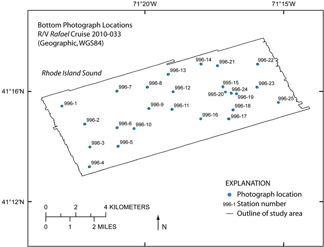
All 116 images of the sea floor in the H11996 study area collected on R/V Rafael cruise 2010-033-FA with the mini SEABOSS system are included. The file-naming convention used includes a three-number abbreviation for the study area (996), an underscore, followed by the station number, the picture letter from that station, and the resolution (tn for thumbnail, mr for medium resolution, and fr for full resolution). For instance, 996_1bmr.jpg is an image from H11996 study area, station 1, picture b, in medium resolution.
Lineage:
Source_Information:
Source_Citation:
Citation_Information:
Originator: USGS (assumed)
Publication_Date: unknown
Title: Information unavailable from original metadata.
Type_of_Source_Media: Information unavailable from original metadata.
Source_Time_Period_of_Content:
Time_Period_Information:
Single_Date/Time:
Calendar_Date: 20100723
Source_Currentness_Reference:
Information unavailable from original metadata. Assumed to be ground condition.
Source_Citation_Abbreviation: Information unavailable from original metadata.
Source_Contribution:
The Mini SEABOSS (SEABed Observation and Sampling System) was designed specifically for the USGS Woods Hole Science Center's 26-foot research boat Rafael. This system is equipped with two video cameras, a digital still camera, and a Van Veen grab sampler. This system, weighing approximately 185 lbs, can be used to depths up to 40 meters. The grab itself is raised and lowered with a 3/16-inch Aramid fiber winch-line with a breaking strength of 5,600 pounds. The davit is secured when the Mini SEABOSS is in the water. The electrical cable is on a spring-wound take-up reel with electrical slip rings that is mounted aft of the sampler. This arrangement protects the 0.38-in. multi-conductor cable and keeps the Mini SEABOSS correctly oriented with the boat. This multi-conductor cable enables communication between the ship's lab and the Mini SEABOSS system. The digital camera, a Minolta Dimage 7Hi, is mounted in a machined Delrin housing with a flat port and is set for 2560 x 1920 pixel images at the "fine" setting for compression. This allows the camera to be used for over 200 images with a 1 GB Compact Flash card without downloading. The system also has a 50 Watt/second flash unit powered by 8 AA batteries. Two battery-powered lasers are set 15 cm apart for scale measurements. The red laser dots can usually be seen in the photo depending on the bottom type and the distance to the sea floor. A third battery powered laser is positioned at an angle so that when it intersects the other lasers, the Mini SEABOSS is at the optimum height off the bottom for a still photograph. The camera is set to a manual focus and set to a default focus distance once the camera is powered up. The default focus distance is slightly less than the optimum height above the seafloor to account for optical distortion under water.
Process_Step:
Process_Description:
The USGS Mini SEABOSS system was deployed to capture still photos and video in the H11996 study area in Rhode Island Sound. This system was used to obtain 1 to 7 still photographs at each station as the R/V Rafael drifted over the seabed for 2 to 5 minutes. The third laser on the system was set to an angle such that the optimum photograph height was 60 cm. The default focus on the camera was set to 50 cm. The imaged area is most often within .3 to 1 meter from left to right. Other camera settings are as follows: aperture is set at f/8; shutter speed is 1/250 second; digital Effects settings are Color +1, Contrast +1, and Filter +1 (Warming). The camera time is set to GMT. A total of 116 images of the seafloor were acquired. Although the images themselves have no georeferencing information, the navigation related to each photograph is available in an ESRI formatted shapefile: 2010-033_996botphotos.shp. This data can be downloaded from the following locations: https://pubs.usgs.gov/of/2011/1005/data/botphotos/2010-033_996botphotos.zip; https://pubs.usgs.gov/of/2011/1005/html/catalog.html.
Process_Date: 2010
Process_Contact:
Contact_Information:
Contact_Person_Primary:
Contact_Person: Dann Blackwood
Contact_Organization: U.S. Geological Survey
Contact_Position: Photographer
Contact_Address:
Address_Type: mailing and physical address
Address: 384 Woods Hole Road
City: Woods Hole
State_or_Province: MA
Postal_Code: 02543-1598
Country: USA
Contact_Voice_Telephone: (508) 548-8700 x2227
Contact_Facsimile_Telephone: (508) 457-2310
Contact_Electronic_Mail_Address: dblackwood@usgs.gov
Process_Step:
Process_Description:
The digital images were recorded on a flash card within the camera. Because this was a fairly short cruise, with few photos, the images were not transferred from the camera until post-cruise, back in the lab. This transfer was accomplished by removing the card from the camera and using a card reader connected to a Mac OSX system.
Process_Date: 2010
Process_Contact:
Contact_Information:
Contact_Person_Primary:
Contact_Person: Dann Blackwood
Contact_Organization: U.S. Geological Survey
Contact_Position: Photographer
Contact_Address:
Address_Type: mailing and physical address
Address: 384 Woods Hole Road
City: Woods Hole
State_or_Province: MA
Postal_Code: 02543
Country: USA
Contact_Voice_Telephone: (508) 548-8700 x2227
Contact_Facsimile_Telephone: (508) 457-2310
Contact_Electronic_Mail_Address: dblackwood@usgs.gov
Process_Step:
Process_Description:
The original JPEG images were renamed from the sequential, camera automatic filename to a filename reflecting station location. This was done for each individual file in Windows Explorer.
Process_Date: 2010
Process_Contact:
Contact_Information:
Contact_Person_Primary:
Contact_Person: Larry Poppe
Contact_Organization: U.S. Geological Survey
Contact_Position: Geologist
Contact_Address:
Address_Type: mailing and physical address
Address: 384 Woods Hole Road
City: Woods Hole
State_or_Province: MA
Postal_Code: 02536
Country: USA
Contact_Voice_Telephone: 508-548-8700 x2314
Contact_Facsimile_Telephone: 508-457-2310
Contact_Electronic_Mail_Address: lpoppe@usgs.gov
Process_Step:
Process_Description:
The full-resolution JPEG images (2560 x 1920 pixels) were downsampled using Photoshop CS to create JPEG images with medium resolution (600 x 450 pixels) and thumbnails (150 x 112 pixels). The filename indicates the image resolution. For instance, the full-resolution JPEG image, 996_1afr.jpg, was downsampled to produce medium-resolution JPEG image, 996_1amr.jpg, and thumbnail 996_1atn.jpg. The levels were adjusted in the following medium-resolution photographs to enhance the image: 1c, 1d, 6b, 6c, 7b, 7c, 11c, 12a, 12b, and 20a.
Process_Date: 2010
Process_Contact:
Contact_Information:
Contact_Person_Primary:
Contact_Person: Katherine McMullen
Contact_Organization: U.S. Geological Survey
Contact_Position: Field and Laboratory Technician
Contact_Address:
Address_Type: mailing and physical address
Address: 384 Woods Hole Road
City: Woods Hole
State_or_Province: MA
Postal_Code: 02543
Country: USA
Contact_Voice_Telephone: (508) 548-8700 x2277
Contact_Facsimile_Telephone: (508) 457-2310
Contact_Electronic_Mail_Address: kmcmullen@usgs.gov
Process_Step:
Process_Description:
Edits to the metadata were made to fix any errors that MP v 2.9.36 flagged. This is necessary to enable the metadata to be successfully harvested for various data catalogs. In some cases, this meant adding text "Information unavailable" or "Information unavailable from original metadata" for those required fields that were left blank. Other minor edits were probably performed (title, publisher, publication place, etc.). Attempted to modify http to https where appropriate. Updated the link to the field activity. The source information was incomplete and had to be modified to meet the standard. The metadata date (but not the metadata creator) was edited to reflect the date of these changes. The metadata available from a harvester may supersede metadata bundled within a download file. Compare the metadata dates to determine which metadata file is most recent.
Process_Date: 20170214
Process_Contact:
Contact_Information:
Contact_Organization_Primary:
Contact_Organization: U.S. Geological Survey
Contact_Person: VeeAnn A. Cross
Contact_Position: Marine Geologist
Contact_Address:
Address_Type: Mailing and Physical
Address: 384 Woods Hole Road
City: Woods Hole
State_or_Province: MA
Postal_Code: 02543-1598
Contact_Voice_Telephone: 508-548-8700 x2251
Contact_Facsimile_Telephone: 508-457-2310
Contact_Electronic_Mail_Address: vatnipp@usgs.gov
Process_Step:
Process_Description: USGS Thesaurus keywords added to the keyword section.
Process_Date: 20180720
Process_Contact:
Contact_Information:
Contact_Organization_Primary:
Contact_Organization: U.S. Geological Survey
Contact_Person: VeeAnn A. Cross
Contact_Position: Marine Geologist
Contact_Address:
Address_Type: Mailing and Physical
Address: 384 Woods Hole Road
City: Woods Hole
State_or_Province: MA
Postal_Code: 02543-1598
Contact_Voice_Telephone: 508-548-8700 x2251
Contact_Facsimile_Telephone: 508-457-2310
Contact_Electronic_Mail_Address: vatnipp@usgs.gov
Process_Step:
Process_Description: Crossref DOI link was added as the first link in the metadata.
Process_Date: 20191118
Process_Contact:
Contact_Information:
Contact_Organization_Primary:
Contact_Organization: U.S. Geological Survey
Contact_Person: VeeAnn A. Cross
Contact_Position: Marine Geologist
Contact_Address:
Address_Type: Mailing and Physical
Address: 384 Woods Hole Road
City: Woods Hole
State_or_Province: MA
Postal_Code: 02543-1598
Contact_Voice_Telephone: 508-548-8700 x2251
Contact_Facsimile_Telephone: 508-457-2310
Contact_Electronic_Mail_Address: vatnipp@usgs.gov
Process_Step:
Process_Description:
Added keywords section with USGS persistent identifier as theme keyword.
Process_Date: 20200908
Process_Contact:
Contact_Information:
Contact_Organization_Primary:
Contact_Organization: U.S. Geological Survey
Contact_Person: VeeAnn A. Cross
Contact_Position: Marine Geologist
Contact_Address:
Address_Type: Mailing and Physical
Address: 384 Woods Hole Road
City: Woods Hole
State_or_Province: MA
Postal_Code: 02543-1598
Contact_Voice_Telephone: 508-548-8700 x2251
Contact_Facsimile_Telephone: 508-457-2310
Contact_Electronic_Mail_Address: vatnipp@usgs.gov
Spatial_Data_Organization_Information:
Direct_Spatial_Reference_Method: Raster
Entity_and_Attribute_Information:
Overview_Description:
Entity_and_Attribute_Overview:
These are digital images with EXIF headers. We have not used, nor verified the accuracy of, the information in the EXIF headers.
Entity_and_Attribute_Detail_Citation: U.S. Geological Survey
Distribution_Information:
Distributor:
Contact_Information:
Contact_Person_Primary:
Contact_Person: Larry Poppe
Contact_Organization: U.S. Geological Survey
Contact_Position: Geologist
Contact_Address:
Address_Type: mailing and physical address
Address: 384 Woods Hole Road
City: Woods Hole
State_or_Province: MA
Postal_Code: 02543-1598
Country: USA
Contact_Voice_Telephone: (508) 548-8700 x2314
Contact_Facsimile_Telephone: (508) 457-2310
Contact_Electronic_Mail_Address: lpoppe@usgs.gov
Resource_Description: Downloadable Data
Distribution_Liability:
Neither the U.S. Government, the Department of the Interior, nor the USGS, nor the National Oceanic and Atmospheric Administration (NOAA), nor any of their employees, contractors, or subcontractors, make any warranty, express or implied, nor assume any legal liability or responsibility for the accuracy, completeness, or usefulness of any information, apparatus, product, or process disclosed, nor represent that its use would not infringe on privately owned rights. The act of distribution shall not constitute any such warranty, and no responsibility is assumed by the USGS or NOAA in the use of these data or related materials. Any use of trade, product, or firm names is for descriptive purposes only and does not imply endorsement by the U.S. Government.
Standard_Order_Process:
Digital_Form:
Digital_Transfer_Information:
Format_Name: JPEG
Digital_Transfer_Option:
Online_Option: Offline_Option:
Offline_Media: DVD-ROM
Recording_Capacity:
Recording_Density: 4.75
Recording_Density_Units: Gbytes
Recording_Format: UDF
Compatibility_Information:
The user must have a system with a DVD capable of reading an UDF standard DVD-R disk.
Fees: None.
Technical_Prerequisites:
These data are available as JPEG images. To utilize these data, the user must have an image viewer capable of opening JPEG images.
Available_Time_Period:
Time_Period_Information:
Single_Date/Time:
Calendar_Date: 2011
Metadata_Reference_Information:
Metadata_Date: 20211116
Metadata_Contact:
Contact_Information:
Contact_Person_Primary:
Contact_Person: Katherine McMullen
Contact_Organization: U.S. Geological Survey
Contact_Position: Field and Laboratory Technician
Contact_Address:
Address_Type: mailing and physical address
Address: 384 Woods Hole Road
City: Woods Hole
State_or_Province: MA
Postal_Code: 02543-1598
Country: USA
Contact_Voice_Telephone: (508) 548-8700 x2277
Contact_Facsimile_Telephone: (508) 457-2310
Contact_Electronic_Mail_Address: whsc_data_contact@usgs.gov
Contact_Instructions:
The metadata contact email address is a generic address in the event the metadata contact is no longer with the USGS or the email is otherwise invalid.
Metadata_Standard_Name: FGDC Content Standards for Digital Geospatial Metadata
Metadata_Standard_Version: FGDC-STD-001-1998
Metadata_Time_Convention: local time
Metadata_Access_Constraints: None
Metadata_Use_Constraints: None

This page is <https://cmgds.marine.usgs.gov/catalog/whcmsc/open_file_report/ofr2011-1005/2010-033_996bphotographs_md.html>
Generated by mp version 2.9.50 on Tue Nov 16 10:06:44 2021