Online Links:
Online Links:
| Range of values | |
|---|---|
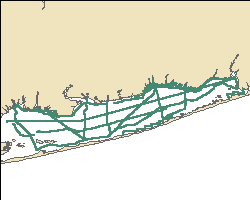
| Minimum: | -73.2509 |
| Maximum: | -72.872283 |
| Units: | decimal degrees |
| Range of values | |
|---|---|
| Minimum: | 40.64225 |
| Maximum: | 40.759267 |
| Units: | decimal degrees |
| Range of values | |
|---|---|
| Minimum: | 0.2 |
| Maximum: | 347.2 |
| Units: | meters |
| Range of values | |
|---|---|
| Minimum: | 13.2 |
| Maximum: | 21.2 |
| Units: | degrees Celsius |
| Range of values | |
|---|---|
| Minimum: | 140 |
| Maximum: | 269 |
| Units: | day |
BEGIN {
FS = ","
}
{
FS = ","
ARGC = 2
depth = -9999
temp = -9999
if ($1=="$GPRMC")
	{
	utctime = $2
	latdeg = substr($4,1,2)
	latmin = substr($4,3,6)
	declat = latdeg + (latmin/60)
	londeg = substr($6,1,3)
	lonmin = substr($6,4,6)
	declon = -1 * (londeg + (lonmin/60))
	if (NR==1) {
		holddepth = -9999
		holdtemp = -9999
		}
	else {
		printf("%s, %9.6f, %9.6f, %5.1f, %5.1f, %s\n", holdutctime, holddeclon, holddeclat, holddepth, holdtemp, ARGV[2])
	}
	holdutctime = utctime
	holddeclon = declon
	holddeclat = declat
	holddepth = -9999
	holdtemp = -9999
	}
if ($1=="$SDDPT")
	{
	depthreal = $2
	holddepth = depthreal
	}
if ($1=="$SDMTW")
	{
	tempreal = $2
	holdtemp = tempreal
	}
}
END {
printf("%s, %9.6f, %9.6f, %5.1f, %5.1f, %s\n", holdutctime, holddeclon, holddeclat, holddepth, holdtemp, ARGV[2])
}
This AWK script was initialized by "dogps" - shell script run under CYGWIN (UNIX like environment that runs under Windows). This is the script used for the May 19 (day 8) data collection:
files=`ls *.gps | cut -d. -f1`
files=`ls *.gps | cut -d. -f1`
for file in $files
do
	awk -f awkhold $file.gps $file >> day8gps.txt
done
The script not only parses the GPS navigation, but concatenates the results into a single file. This script was repeated for days 9, 10, and 11 (May 20, May 21 and May 22 respectively) with the output directed to day9gps.txt, day10gps.txt, and day11gps.txt. For the September cruise, the output files were sept2208gps.txt, sept2308gps.txt, sept2408gps.txt and sept2508gps.txt.
| Access_Constraints | None. |
|---|---|
| Use_Constraints | The public domain data from the U.S. Government are freely redistributable with proper metadata and source attribution. Please recognize the U.S. Geological Survey as the originator of the dataset. |
| Data format: | This WinZip (version 9.0) file contains the point shapefile as well as the associated metadata files. in format Shapefile (version ArcGIS 9.2) Size: 1 |
|---|---|
| Network links: |
https://pubs.usgs.gov/of/2011/1040/data/navigation/resgpspnts_gsbay.zip https://pubs.usgs.gov/of/2011/1040/ |