Shot point navigation at even 500 shot intervals for EdgeTech SB-512i chirp seismic-reflection data collected in Buzzards Bay by the U.S. Geological Survey offshore of Massachusetts in 2009, 2010, and 2011 (BB_SeismicShot_500 Esri Point Shapefile, Geographic, WGS84).

Metadata also available as - [Outline] - [Parseable text] - [XML]

Frequently anticipated questions:


What does this data set describe?

Title:
Shot point navigation at even 500 shot intervals for EdgeTech SB-512i chirp seismic-reflection data collected in Buzzards Bay by the U.S. Geological Survey offshore of Massachusetts in 2009, 2010, and 2011 (BB_SeismicShot_500 Esri Point Shapefile, Geographic, WGS84).
Abstract:
These data were collected under a cooperative agreement between the Massachusetts Office of Coastal Zone Management (CZM) and the U.S. Geological Survey (USGS), Coastal and Marine Geology Program, Woods Hole Coastal and Marine Science Center (WHSC). Initiated in 2003, the primary objective of this program is to develop regional geologic framework information for the management of coastal and marine resources. Accurate data and maps of seafloor geology are important first steps toward protecting fish habitat, delineating marine resources, and assessing environmental changes due to natural or human impacts. The project is focused on the inshore waters of coastal Massachusetts, primarily in water depths of 5 to 30 meters (m) deep. Data collected for the mapping cooperative have been released in a series of USGS Open-File Reports (http://woodshole.er.usgs.gov/project-pages/coastal_mass/). The data collected in the study area in Buzzards Bay, Massachusetts, include high-resolution geophysics (bathymetry, backscatter intensity, and seismic reflection) and ground validation (sediment samples, video tracklines, and bottom photographs). The geophysical data are released in USGS Open-File Report 2012-1002, High-Resolution Geophysical Data from the Inner Continental Shelf: Buzzards Bay, Massachusetts (http://pubs.usgs.gov/of/2012/1002/). The sampling data have not been prepared for publication yet. The geophysical data were collected during four separate surveys conducted between 2004 and 2011 (National Oceanic and Atmospheric Administration (NOAA) survey H11319 (in 2004; bathymetry only) and USGS surveys 2009-002-FA, 2010-004-FA, and 2011-004-FA)) and cover 410 square kilometers of the inner continental shelf. More information about the individual USGS surveys conducted as part of the Buzzards Bay project can be found on WHCS Field Activity Web pages: 2009-002-FA: http://woodshole.er.usgs.gov/operations/ia/public_ds_info.php?fa=2009-002-FA 2010-004-FA: http://woodshole.er.usgs.gov/operations/ia/public_ds_info.php?fa=2010-004-FA 2011-004-FA: http://woodshole.er.usgs.gov/operations/ia/public_ds_info.php?fa=2011-004-FA Information about the NOAA survey can be found at: H11319: http://surveys.ngdc.noaa.gov/mgg/NOS/coast/H10001-H12000/H11319/DR/
  1. How might this data set be cited?
    U.S. Geological Survey, 2013, Shot point navigation at even 500 shot intervals for EdgeTech SB-512i chirp seismic-reflection data collected in Buzzards Bay by the U.S. Geological Survey offshore of Massachusetts in 2009, 2010, and 2011 (BB_SeismicShot_500 Esri Point Shapefile, Geographic, WGS84).: Open-File Report 2012-1002, U.S. Geological Survey, Coastal and Marine Geology Program, Woods Hole Coastal and Marine Science Center, Woods Hole, Massachusetts.

    Online Links:

    This is part of the following larger work.

    Ackerman, Seth D., Andrews, Brian D., Foster, David S., Baldwin, Wayne E., and Schwab, William C., 2013, High-Resolution Geophysical Data from the Inner Continental Shelf: Buzzards Bay, Massachusetts.: Open-File Report 2012-1002, U.S. Geological Survey, Reston, VA.

    Online Links:

  2. What geographic area does the data set cover?
    West_Bounding_Coordinate: -71.122278
    East_Bounding_Coordinate: -70.649092
    North_Bounding_Coordinate: 41.669965
    South_Bounding_Coordinate: 41.370294
  3. What does it look like?
    http://pubs.usgs.gov/of/2012/1002/GIS/browse_jpg/big/BB_SeismicShot_500.jpg (JPEG)
    Shot point navigation at even 500 shot intervals for EdgeTech 512i chirp seismic-reflection data collected offshore of Massachusetts within Buzzards Bay
  4. Does the data set describe conditions during a particular time period?
    Beginning_Date: 28-May-2009
    Ending_Date: 14-May-2011
    Currentness_Reference:
    ground condition of individual surveys on the following dates: 20090528-20090618; 20100515-20100520; 20110513-20110514
  5. What is the general form of this data set?
    Geospatial_Data_Presentation_Form: vector digital data
  6. How does the data set represent geographic features?
    1. How are geographic features stored in the data set?
      This is a Vector data set. It contains the following vector data types (SDTS terminology):
      • Entity point (23136)
    2. What coordinate system is used to represent geographic features?
      Horizontal positions are specified in geographic coordinates, that is, latitude and longitude. Latitudes are given to the nearest 0.000001. Longitudes are given to the nearest 0.000001. Latitude and longitude values are specified in Decimal degrees. The horizontal datum used is D_WGS_1984.
      The ellipsoid used is WGS_1984.
      The semi-major axis of the ellipsoid used is 6378137.000000.
      The flattening of the ellipsoid used is 1/298.257224.
  7. How does the data set describe geographic features?
    BB_SeismicShot_500
    shot point navigation for seismic profiles (500 shot interval) (Source: USGS)
    FID
    Internal feature number. (Source: ESRI) Sequential unique whole numbers that are automatically generated.
    Shape
    Feature geometry. (Source: ESRI) Coordinates defining the features.
    East
    Easting coordinate in UTM Zone 19 meters, WGS84 (Source: USGS)
    Range of values
    Minimum:322837.93
    Maximum:362347.96
    Units:meters
    Resolution:0.01
    North
    Northing coordinate in UTM Zone 19 meters, WGS84 (Source: USGS)
    Range of values
    Minimum:4581843.11
    Maximum:4614500.65
    Units:meters
    Resolution:0.01
    Lon
    Longitude coordinate in decimal degrees, WGS84 (Source: USGS)
    Range of values
    Minimum:-71.122278
    Maximum:-70.649092
    Units:decimal degrees
    Resolution:0.000001
    Lat
    Latitude coordinate in decimal degrees, WGS84 (Source: USGS)
    Range of values
    Minimum:41.370294
    Maximum:41.669965
    Units:decimal degrees
    Resolution:0.000001
    FileName
    Name of seismic data file (Source: USGS) Character string of width 254
    ImageName
    Name of seismic profile image (Source: USGS) Character string of width 254
    Shot
    Name of seismicShot number (first, last, and every 500 shot between) (Source: USGS)
    Range of values
    Minimum:1
    Maximum:67981
    Units:shot number
    Resolution:1
    Year
    Calendar year data were collected (Source: USGS)
    Range of values
    Minimum:2009
    Maximum:2011
    Units:Calendar year
    Resolution:1
    JulDay
    Julian day data were collected (Source: USGS)
    Range of values
    Minimum:133
    Maximum:169
    Units:Julian day data were collected where Julian day is the integer number representing the interval of time in days since January 1 of the year of collection.
    Resolution:1
    UTC
    UTC time of seismic shot (HH:MM:SS) (Source: USGS) String up to 254 characters
    oldEast
    pre-layback calculation Easting coordinate in UTM Zone 19 meters, WGS84. Attribute value is "n/a" for shots where the seismic sled navigation is valid and no post-processing was necessary to calculate the layback easting coordinate for the actual shot/trace positions. (Source: USGS) String up to 254 characters
    oldNorth
    pre-layback calculation Northing coordinate in UTM Zone 19 meters, WGS84. Attribute value is "n/a" for shots where the seismic sled navigation is valid and no post-processing was necessary to calculate the layback northing coordinate for the actual shot/trace positions. (Source: USGS) String up to 254 characters
    SurveyID
    WHSC field activity identifier in the new style (e.g. "2009-002-FA" where 2009 is the survey year, 002 is survey number of that year, and FA is Field Activity); Note the old style of this would be represented as "09002" (Source: USGS) Character string of width 10
    DeviceID
    Sonar device used to collect seismic-reflection data (Source: USGS) Character string of width 15
    VehicleID
    Survey vessel name (Source: USGS) Character string of width 25

Who produced the data set?

  1. Who are the originators of the data set? (may include formal authors, digital compilers, and editors)
    • U.S. Geological Survey
  2. Who also contributed to the data set?
  3. To whom should users address questions about the data?
    Wayne Baldwin
    U.S. Geological Survey
    Geologist
    384 Woods Hole Rd.
    Woods Hole, MA
    USA

    508-548-8700 x2226 (voice)
    508-457-2310 (FAX)
    wbaldwin@usgs.gov

Why was the data set created?

This dataset contains shot point navigation at even 500 shot intervals for 4500 km of EdgeTech SB-512i chirp seismic-reflection data collected by the U.S. Geological Survey during three Woods Hole Science Center cruises (2009-002-FA , 2010-004-FA, and 2011-004-FA) offshore of Massachusetts within Buzzards Bay.

How was the data set created?

  1. From what previous works were the data drawn?
    none (source 1 of 1)
    U.S. Geological Survey, Unpublished Material, raw seismic navigation.

    Type_of_Source_Media: disc
    Source_Contribution:
    Seismic-reflection data acquisition 2009-002-FA: Chirp seismic data were collected using an EdgeTech Geo-Star FSSB sub-bottom profiling system and an SB-0512i towfish (0.5-12 kHz), which was mounted on a catamaran and towed astern of the M/V Megan T. Miller of Port Jefferson, NY. Chesapeake Technologies' SonarWiz (v.4.04.0031) seismic acquisition software was used to control the Geo-Star topside unit, digitally log trace data in the SEG-Y Rev. 1 format (IEEE floating point), and record GPS navigation coordinates to the SEG-Y trace headers (in arc seconds of Latitude and Longitude, multiplied by a scalar of 100). Over Julian days 148 - 158 (Files l1f1 - l154f1) data were acquired using a 0.12-s shot rate, a 20-ms pulse length, and a 0.7 to 12 kHz frequency sweep. File l155f1 was acquired using a 0.12-s shot rate, a 30-ms pulse length, and a 0.5 - 7.2 kHz frequency sweep. Data over Julian days 159 - 169 were acquired using a 0.12-s shot rate, a 20-ms pulse length, and a 2 - 12 kHz frequency sweep. Traces were recorded in depth, assuming a constant sound velocity of 1500 m/s, with trace lengths of approximately 66 m (1250 samples/trace and .000053-s sample interval), 198 m (3744 samples/trace and .000053-s sample interval), and 132 m (2492 samples/trace and .000053-s sample interval) for the respective acquisition configurations. Seismic-reflection data acquisition 2010-004-FA: Chirp seismic data were collected using an EdgeTech Geo-Star FSSB sub-bottom profiling system and an SB-0512i towfish (0.5-12 kHz), which was mounted on a catamaran and towed astern of the M/V Megan T. Miller of Port Jefferson, NY. Chesapeake Technologies' SonarWiz (v.4.04.0111) seismic acquisition software was used to control the Geo-Star topside unit, digitally log trace data in the SEG-Y Rev. 1 format (IEEE floating point), and record GPS navigation coordinates to the SEG-Y trace headers (in arc seconds of Latitude and Longitude, multiplied by a scalar of 100). Data were acquired using a 0.25-s shot rate, a 5-ms pulse length, and a 0.5 to 8 kHz frequency sweep. Recorded trace lengths were approximately 100 ms (2170 samples/trace and .000046-s sample interval). Seismic-reflection data acquisition 2011-004-FA: Chirp seismic data were collected using an EdgeTech Geo-Star FSSB sub-bottom profiling system and an SB-0512i towfish (0.5-12 kHz), which was mounted on a catamaran and towed astern of the M/V Scarlett Isabella of Cape May, NJ. Chesapeake Technologies' SonarWiz (v.5.03.0016) seismic acquisition software was used to control the Geo-Star topside unit, digitally log trace data in the SEG-Y Rev. 1 format (IEEE floating point), and record GPS navigation coordinates to the SEG-Y trace headers (in arc seconds of Latitude and Longitude, multiplied by a scalar of 100). Data were acquired using a 0.25-s shot rate, a 5-ms pulse length, and a 0.5 to 8 kHz frequency sweep. Recorded trace lengths were approximately 200 ms (4340 samples/trace and .000046-s sample interval).
  2. How were the data generated, processed, and modified?
    Date: Oct-2011 (process 1 of 8)
    SIOSEIS (version 2010.2.25) was used to read SEG-Y files, renumber shots starting from one, and write out new SEG-Y files. The original shot numbers, which were assigned by SonarWiz sequentially over the duration of an acquisition session despite SEG-Y file changes, are preserved in the raw SEG-Y data. Person who carried out this activity:
    Wayne Baldwin
    U.S. Geological Survey
    Geologist
    384 Woods Hole Rd
    Woods Hole, MA
    USA

    508-548-8700 x2226 (voice)
    508-457-2310 (FAX)
    wbaldwin@usgs.gov
    Date: Oct-2011 (process 2 of 8)
    Seismic Unix (version 4.2) was used to read renumbered SEG-Y files, write a Seismic Unix file, and extract SEG-Y trace header information, including shot number, longitude, latitude, year, Julian day, and time of day (UTC). Header information from each SEG-Y file was saved to text files after an AWK (no version) filter was used to maintain the first and last shots, shots at multiples of 100, and shots with unique navigation coordinates. Geographic coordinates (WGS84) were converted to UTM zone 19 coordinates (WGS84) using Proj (version 4.6.0). End shots and shots at multiples of 100 may not have unique navigation coordinates. Separate text files containing the first and last shots and even 500 shot intervals were also saved. A 500 shot interval was chosen because it corresponds to the annotation interval provided along the top of the seismic-reflection profile images, which are included in the '2009-002-FA', '2010-004-FA', and '2011-004-FA' folders within 'GIS\hyperlink_images\'. During 2009-002-FA, erroneous coordinates were intermittently recorded to the SEG-Y trace headers due to technical difficulties with the GPS systems. In these instances (portions of l1f1, l1f3, l155f1, l158f1, l223f1, l269f1, and all of l156f1 - l157f2, l224f1 - l238f1, l243-l245f1, l288f1 - l299f1), scripts utilizing AWK (no version), Proj (version 4.6.0), and the Unix commands egrep, join, sort, and cat were used to replace coordinates in the text files created by the process described above with correct navigation from HYPACK raw files. The following steps were performed for each effected file, over the specific time periods containing bad navigation: 1) navigation data were extracted from HYPACK raw files, creating a text file containing fields for Longitude, Latitude, and Julian day/UTC time (JD:HH:MM:SS); 2) records for the first and last shots, shots at multiples of 100, and the first record for each UTC second (files generally contain 4-5 shots per UTC second since the Chirp shot rate is 4 Hz, while navigation update frequency is 1 Hz) were extracted from the original text files, and saved to new text files, only maintaining fields for LineName, ImageName, Shot, Year, and Julian day/UTC time (JD:HH:MM:SS); 3) files from the two previous steps were joined using the common field Julian day/UTC time (JD:HH:MM:SS); and 4) Geographic coordinates (WGS84) were converted to UTM zone 19 coordinates (WGS84) using Proj (version 4.6.0). The corrected navigation text files were substituted for the effected portions of the original data. Person who carried out this activity:
    Wayne Baldwin
    U.S. Geological Survey
    Geologist
    384 Woods Hole Rd
    Woods Hole, MA
    USA

    508-548-8700 x2226 (voice)
    508-457-2310 (FAX)
    wbaldwin@usgs.gov
    Date: Oct-2011 (process 3 of 8)
    An AWK (no version) script was used to apply layback to seismic navigation acquired during portions of the 2009-002-FA and 2010-004-FA surveys when shipboard DGPS was used in lieu of the non-operational GPS receiver mounted on the towed catamaran vehicle. (This includes portions of l1f1, l1f3, l155f1, l158f1, l223f1, l269f1, and all of l156f1 - l157f2, l224f1 - l238f1, l243f1 - l257f1, l270f1 - l372f1 collected on 2009-002-FA; and a portion of l63f1 and subsequent data collected over Julian days 138 - 140 on 2010-004-FA. Attributes oldEast and oldNorth in the table 'BB_SeismicShot_unique.csv', which is included in the zip compressed version of the shapefile 'BB_SeismicShot_500.shp', document pre-layback shot/trace positions). The script utilized a read-and-do loop to calculate and apply layback offsets to trace positions. During the initial loop through the script: 1) Easting and northing coordinates (UTM Zone 19, WGS84) for the first five traces of input navigation were read and easting and northing differentials between the consecutive positions were calculated; 2) The signs (+/-) of the differential values were compared to a look-up table to determine the appropriate conversion of the arc tangent (atan2(dy,dx)) angle between consecutive positions to a polar azimuth; 3) The average of the polar azimuths was calculated; 4) The sine and cosine of the average azimuth was calculated and multiplied by the linear distance between the catamaran and the shipboard DGPS receiver (33 m during 2009-002-FA, and 31 or 37 m during 2010-004-FA), providing absolute values for easting and northing offsets, respectively; 5) A look-up table was used to determine the quadrant of the average azimuth and appropriately add or subtract the calculated offsets to the easting and northing coordinates of the first three input traces, producing final layback positions for those traces; 6) Layback and original easting and northing coordinates for the three adjusted traces were printed to a new layback navigation file that also retained additional attributes input records; and 7) Easting and northing coordinates of the fourth and fifth traces, the three azimuths computed between traces two, three, four, and five, and the average azimuth were held as input for calculations conducted in the subsequent loop. During subsequent loops through the script: 1) Easting and northing coordinates for three additional traces from input navigation were read, and easting and northing differentials were calculated between the consecutive positions, including the last trace position held from the previous loop; 2) Three new polar azimuths were calculated using the differential values, then a new average azimuth was calculated from the three that were held, the new three, and the average held from the previous loop (the previously calculated average was factored into the new average to smooth "kinks" along the layback navigation that can result from significantly different average azimuths calculated from one loop to the next); 3) new layback offset values were computed, and applied to the easting and northing coordinates of the last two traces input during the previous loop, and the fist trace input during the present loop; 4) layback and original easting and northing coordinates for the three adjusted traces were appended to the layback navigation file started in the previous loop; and 5) easting and northing coordinates of the second and third traces, the three new azimuths, and the average azimuth from the present loop were held as input for calculations conducted in the subsequent loop. Near the end of the input navigation file: 1) if less than three traces were present during a new loop, the layback offsets calculated during the previous loop were applied to remaining trace coordinates; 2) layback and original easting and northing coordinates for the remaining adjusted traces were appended to the layback navigation file; and 3) the script reached its end, closed, and saved the layback navigation file. In this fashion, the script approximated a moving window, in which the average of six trace-to-trace azimuths was used to calculate layback offsets for three central trace positions. Exceptions were at the start of a file, where the first three input trace positions were adjusted using offsets calculated from the average of only four azimuths, and possibly at the end of a file, where remaining traces may have been adjusted using the offsets calculated during the previous loop. Person who carried out this activity:
    Wayne Baldwin
    U.S. Geological Survey
    Geologist
    384 Woods Hole Rd
    Woods Hole, MA
    USA

    508-548-8700 x2226 (voice)
    508-457-2310 (FAX)
    wbaldwin@usgs.gov
    Date: Oct-2011 (process 4 of 8)
    AWK was used to filter the unique navigation text files to generate additional text files containing the first and last shots, and even 500 shot positions for each seismic line (including the layback-adjusted SB-512i lines from 2009-002-FA and 2010-004-FA). The 500 shot text files were concatenated into a comma-delimited text file, AWK was used to add and populate attribute fields 'SurveyID', 'DeviceID', and 'VehicleID', then the text file was imported into ArcMap (version 9.3) using 'Add XY data' and saved as points (Geographic, WGS84) in the Esri shapefile format. Person who carried out this activity:
    Wayne Baldwin
    U.S. Geological Survey
    Geologist
    384 Woods Hole Rd
    Woods Hole, MA
    USA

    508-548-8700 x2226 (voice)
    508-457-2310 (FAX)
    wbaldwin@usgs.gov
    Date: 08-Dec-2015 (process 5 of 8)
    Edits to the metadata were made to fix any errors that MP v 2.9.32 flagged. This is necessary to enable the metadata to be successfully harvested for various data catalogs. In some cases, this meant adding text "Information unavailable" or "Information unavailable from original metadata" for those required fields that were left blank. Other minor edits were probably performed (title, publisher, publication place, etc.). The metadata date (but not the metadata creator) was edited to reflect the date of these changes. The metadata available from a harvester may supersede metadata bundled within a download file. Compare the metadata dates to determine which metadata file is most recent. Person who carried out this activity:
    U.S. Geological Survey
    Attn: VeeAnn A. Cross
    Marine Geologist
    384 Woods Hole Rd
    Woods Hole, MA

    508-548-8700 x2251 (voice)
    508-457-2310 (FAX)
    vatnipp@usgs.gov
    Date: 20-Jul-2018 (process 6 of 8)
    USGS Thesaurus keywords added to the keyword section. Person who carried out this activity:
    U.S. Geological Survey
    Attn: VeeAnn A. Cross
    Marine Geologist
    384 Woods Hole Road
    Woods Hole, MA

    508-548-8700 x2251 (voice)
    508-457-2310 (FAX)
    vatnipp@usgs.gov
    Date: 18-Nov-2019 (process 7 of 8)
    Crossref DOI link was added as the first link in the metadata. Person who carried out this activity:
    U.S. Geological Survey
    Attn: VeeAnn A. Cross
    Marine Geologist
    384 Woods Hole Road
    Woods Hole, MA

    508-548-8700 x2251 (voice)
    508-457-2310 (FAX)
    vatnipp@usgs.gov
    Date: 08-Sep-2020 (process 8 of 8)
    Added keywords section with USGS persistent identifier as theme keyword. Person who carried out this activity:
    U.S. Geological Survey
    Attn: VeeAnn A. Cross
    Marine Geologist
    384 Woods Hole Road
    Woods Hole, MA

    508-548-8700 x2251 (voice)
    508-457-2310 (FAX)
    vatnipp@usgs.gov
  3. What similar or related data should the user be aware of?
    Stockwell, John, 2011, CWP/SU: Seismic Uni*x: Center for Wave Phenomena - Colorado School of Mines, Golden, CO.

    Online Links:

    Henkart, Paul, 2011, SIOSEIS: Scripps Institution of Oceanography, University of California - San Diego, LaJolla, CA.

    Online Links:

    Michael W. Norris and Alan K. Faichney, 2002, SEGY Rev.1 Data Exchange Format1: Society of Exploration Geophysicists, Tulsa, OK.

    Online Links:


How reliable are the data; what problems remain in the data set?

  1. How well have the observations been checked?
    All attributes were checked in a consistent manner.
  2. How accurate are the geographic locations?
    Field activity 2009-002-FA: The SB-0512i was mounted on a catamaran sled and towed at the sea surface approximately 30 - 40 m astern of the M/V Megan T. Miller. Position data were provided by a Global Positioning System (GPS) navigation receiver mounted on the catamaran, and data were transmitted to the acquisition computer on the vessel via a 2.4 GHz radio link. Technical difficulties during portions of 2009-002-FA caused the GPS system mounted on the catamaran to malfunction, so DGPS navigation was obtained from a receiver mounted on top of the acquisition van (This applies to portions of l1f1, l1f3, l155f1, l158f1, l223f1, l269f1, and all of l156f1 - l157f2, l224f1 - l238f1, l243f1 - l257f1, l270f1 - l372f1). Layback positions, which account for the linear distance between the shipboard DGPS receiver and the towed catamaran vehicle, were calculated trigonometrically during post-processing (see processing step 3). While the vehicle mounted GPS antenna was operational, positional accuracy is assumed to be ± 10 m. While the vehicle mounted GPS was not operational, positional accuracy is assumed to be ± 20 m; increased uncertainty arises because layback calculations do not account for fish motion behind the vessel, which is caused by sea state and vessel speed induced changes in the angle and scope of the tow cable. Field activity 2010-004-FA: The SB-0512i was mounted on a catamaran sled and towed at the sea surface approximately 30 - 40 m astern of the M/V Megan T. Miller. Technical difficulties during portions of 2010-004-FA caused the GPS system mounted on the catamaran to malfunction, so DGPS navigation was obtained from a receiver mounted above on top of the acquisition van (this applies to a portion of l63f1 and subsequent data collected over Julian days 138 - 140). Layback positions, which account for the linear distance between the shipboard DGPS receiver and the towed catamaran vehicle, were calculated trigonometrically during post-processing (see processing step 3). While the vehicle mounted GPS antenna was operational, positional accuracy is assumed to be ± 10 m. While the vehicle mounted GPS was not operational, positional accuracy is assumed to be ± 20 m; increased uncertainty arises because layback calculations do not account for fish motion behind the vessel, which is caused by sea state and vessel speed induced changes in the angle and scope of the tow cable. Field activity 2011-004-FA: The SB-0512i was mounted on a catamaran sled and towed at the sea surface approximately 50 m astern of the M/V Scarlett Isabella. Position data were provided by a Global Positioning System (GPS) navigation receiver mounted on the catamaran, and data were transmitted to the acquisition computer on the vessel via a 2.4 GHz radio link. Positional accuracy is assumed to be ± 10 m.
  3. How accurate are the heights or depths?
  4. Where are the gaps in the data? What is missing?
    Sections of tracklines where navigation was recorded but no seismic data were logged are not included. Only the subsets of seismic-reflection data collected during field activities 2009-002-FA, 2010-004-FA, and 2011-004-FA that are within the Buzzards Bay study are included in this spatial dataset. Trackline navigation for approximately 3800 km of additional seismic-reflection profiles collected within Vineyard Sound, Massachusetts during these field activities were published in USGS Open-File Report 2012-1006 High-Resolution Geophysical Data from the Inner Continental Shelf: Vineyard Sound, Massachusetts (http://pubs.usgs.gov/of/2012/1006/).
  5. How consistent are the relationships among the observations, including topology?
    Any spurious data points were removed during processing. For each seismic trackline there is one seismic-profile image that is hyperlinked by the field 'ImageName'. No duplicates exist.

How can someone get a copy of the data set?

Are there legal restrictions on access or use of the data?
Access_Constraints None
Use_Constraints Public domain data from the U.S. Government are freely redistributable with proper metadata and source attribution. Please recognize the U.S. Geological Survey as the source of this information
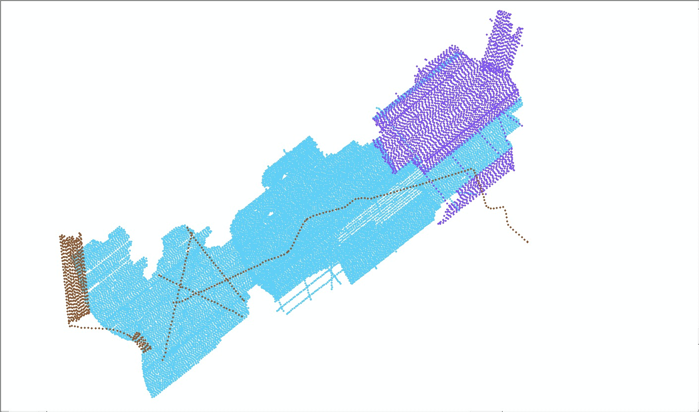
  1. Who distributes the data set? (Distributor 1 of 1)
    Wayne Baldwin
    U.S. Geological Survey, Woods Hole Science Center
    Geologist
    384 Woods Hole Rd.
    Woods Hole, MA
    USA

    508-548-8700 x2226 (voice)
    wbaldwin@usgs.gov
  2. What's the catalog number I need to order this data set? Downloadable Data
  3. What legal disclaimers am I supposed to read?
    Neither the U.S. Government, the Department of the Interior, nor the USGS, nor any of their employees, contractors, or subcontractors, make any warranty, express or implied, nor assume any legal liability or responsibility for the accuracy, completeness, or usefulness of any information, apparatus, product, or process disclosed, nor represent that its use would not infringe on privately owned rights. The act of distribution shall not constitute any such warranty, and no responsibility is assumed by the USGS in the use of these data or related materials. Any use of trade, product, or firm names is for descriptive purposes only and does not imply endorsement by the U.S. Government.
  4. How can I download or order the data?
    • Availability in digital form:
      Data format: This Zip file contains shot point navigation at even 500 shot intervals (BB_SeismicShot_500.shp) for EdgeTech SB-512i chirp seismic-reflection data collected by the U.S. Geological Survey offshore of Massachusetts within Buzzards Bay. The Zip file also contains a comma delimited file (BB_SeismicShot_unique.csv), that contains every unique shot point for the same surveys. This also includes associated metadata. in format SHP (version ArcGIS 9.3) Esri point shapefile Size: 45
      Network links: http://pubs.usgs.gov/of/2012/1002/GIS/shapefile/BB_SeismicShot_500.zip
      Media you can order: DVD-ROM (Density 4.75 GB) (format UDF)
    • Cost to order the data: none

  5. What hardware or software do I need in order to use the data set?
    This zip file contains data available in Esri shapefile format. The zip file also contains associated metadata. The user must have software capable of uncompressing the zip file and displaying the shapefile. In lieu of ArcView or ArcGIS, the user may utilize another GIS application package capable of importing the data. A free data viewer, ArcExplorer, capable of displaying the data is available from Esri at www.esri.com.

Who wrote the metadata?

Dates:
Last modified: 18-Mar-2024
Metadata author:
Wayne Baldwin
U.S. Geological Survey
Geologist
384 Woods Hole Rd.
Woods Hole, MA
USA

508-548-8700 x2226 (voice)
508-457-2310 (FAX)
whsc_data_contact@usgs.gov
Contact_Instructions:
The metadata contact email address is a generic address in the event the person is no longer with USGS. (updated on 20240318)
Metadata standard:
FGDC Content Standards for Digital Geospatial Metadata (FGDC-STD-001-1998)

This page is <https://cmgds.marine.usgs.gov/catalog/whcmsc/open_file_report/ofr2012-1002/bb_seismicshot_500.shp.faq.html>
Generated by mp version 2.9.51 on Mon Mar 25 16:05:40 2024