Outline the Combined 4-m Multibeam Bathymetry Generated from National Oceanic and Atmospheric Administration (NOAA) Surveys H12009, H12010, H12011, H12015, H12033, H12137, and H12139 offshore in Block Island Sound (BISOUND_OUTLINE shapefile, Geographic, WGS84)

Metadata also available as - [Outline] - [Parseable text] - [XML]

Frequently anticipated questions:


What does this data set describe?

Title:
Outline the Combined 4-m Multibeam Bathymetry Generated from National Oceanic and Atmospheric Administration (NOAA) Surveys H12009, H12010, H12011, H12015, H12033, H12137, and H12139 offshore in Block Island Sound (BISOUND_OUTLINE shapefile, Geographic, WGS84)
Abstract:
The USGS, in cooperation with NOAA, is producing detailed maps of the seafloor off southern New England. The current phase of this cooperative research program is directed toward analyzing how bathymetric relief relates to the distribution of sedimentary environments and benthic communities. As part of this program, digital terrain models (DTMs) from bathymetry collected as part of NOAA's hydrographic charting activities are converted into ESRI raster grids and imagery, verified with bottom sampling and photography, and used to produce interpretations of seabed geology and hydrodynamic processes. Although each of the 7 continuous-coverage, completed surveys individually provides important benthic environmental information, many applications require a geographically broader perspective. For example, the usefulness of individual surveys is limited for the planning and construction of cross-Sound infrastructure, such as cables and pipelines, or for the testing of regional circulation models. To address this need, we integrated the 7 contiguous multibeam bathymetric DTMs into one dataset that covers much of Block Island Sound. The new dataset is adjusted to mean lower low water, is provided in UTM Zone 19 NAD83 and geographic WGS84 projections, and is gridded to 4-m resolution. This resolution is adequate for seafloor-feature and process interpretation, but small enough to be queried and manipulated with standard GIS programs and to allow for future growth. Natural features visible in the grid include boulder lag deposits of submerged moraines, sand-wave fields, and scour depressions that reflect the strength of the oscillating tidal currents. Bedform asymmetry allows interpretations of net sediment transport. Together the merged data reveal a larger, more continuous perspective of bathymetric topography than previously available, providing a fundamental framework for research and resource management activities off this portion of the Rhode Island coast.
  1. How might this data set be cited?
    U.S. Geological Survey, and National Oceanic and Atmospheric Administration, 2012, Outline the Combined 4-m Multibeam Bathymetry Generated from National Oceanic and Atmospheric Administration (NOAA) Surveys H12009, H12010, H12011, H12015, H12033, H12137, and H12139 offshore in Block Island Sound (BISOUND_OUTLINE shapefile, Geographic, WGS84): Open-File Report 2012-1005, U.S. Geological Survey, Coastal and Marine Geology Program, Woods Hole Coastal and Marine Science Center, Woods Hole, MA.

    Online Links:

    This is part of the following larger work.

    Poppe, L.J., Danforth, W.W., McMullen, K.Y., Blankenship, M.A., Glomb, K.A., Wright, D.B., and Smith, S.M., 2012, Sea-Floor Character and Sedimentary Processes of Block Island Sound, Offshore Rhode Island: Open-File Report 2012-1005, U.S. Geological Survey, Reston, VA.

    Online Links:

    Other_Citation_Details: 1 DVD-ROM
  2. What geographic area does the data set cover?
    West_Bounding_Coordinate: -71.868434
    East_Bounding_Coordinate: -71.368224
    North_Bounding_Coordinate: 41.330098
    South_Bounding_Coordinate: 41.115651
  3. What does it look like?
    http://pubs.usgs.gov/of/2012/1005/data/basemaps/outline/bisound_outline.gif (GIF)
    Thumbnail image showing the outline of the combined bathymetry from NOAA surveys H12009, H12010, H12011, H12015, H12033, H12137, and H12139 offshore in Block Island Sound in geographic, WGS84 coordinates.
  4. Does the data set describe conditions during a particular time period?
    Beginning_Date: 08-May-2009
    Ending_Date: 14-Oct-2009
    Currentness_Reference:
    ground condition
  5. What is the general form of this data set?
    Geospatial_Data_Presentation_Form: vector digital data
  6. How does the data set represent geographic features?
    1. How are geographic features stored in the data set?
      This is a Vector data set. It contains the following vector data types (SDTS terminology):
      • G-polygon (2)
    2. What coordinate system is used to represent geographic features?
      Horizontal positions are specified in geographic coordinates, that is, latitude and longitude. Latitudes are given to the nearest 0.000043. Longitudes are given to the nearest 0.000043. Latitude and longitude values are specified in Decimal degrees. The horizontal datum used is D_WGS_1984.
      The ellipsoid used is WGS_1984.
      The semi-major axis of the ellipsoid used is 6378137.000000.
      The flattening of the ellipsoid used is 1/298.257224.
  7. How does the data set describe geographic features?
    bisound_outline
    Shapefile (Source: None)
    FID
    Internal feature number. (Source: ESRI) Whole numbers that are automatically generated.
    Shape
    Feature geometry. (Source: ESRI) Coordinates defining the features.
    ID
    Attribute automatically generated when the graphic was converted to a shapefile. (Source: Software generated) Whole numbers that are automatically generated
    Area
    Area of the combined multibean data (Source: Scientist)
    Range of values
    Minimum:0.002
    Maximum:633.636
    Units:kilometers
    Resolution:0.001
    Entity_and_Attribute_Overview:
    Outline of the combined bathymetry data from NOAA surveys H12009, H12010, H12011, H12015, H12033, H12137, and H12139 offshore in Block Island Sound in geographic, WGS84 coordinates.
    Entity_and_Attribute_Detail_Citation: U.S. Geological Survey

Who produced the data set?

  1. Who are the originators of the data set? (may include formal authors, digital compilers, and editors)
    • U.S. Geological Survey
    • National Oceanic and Atmospheric Administration
  2. Who also contributed to the data set?
  3. To whom should users address questions about the data?
    U.S. Geological Survey
    Attn: Larry Poppe
    Geologist
    384 Woods Hole Road
    Woods Hole, MA

    508-548-8700 x2314 (voice)
    508-457-2310 (FAX)
    lpoppe@usgs.gov

Why was the data set created?

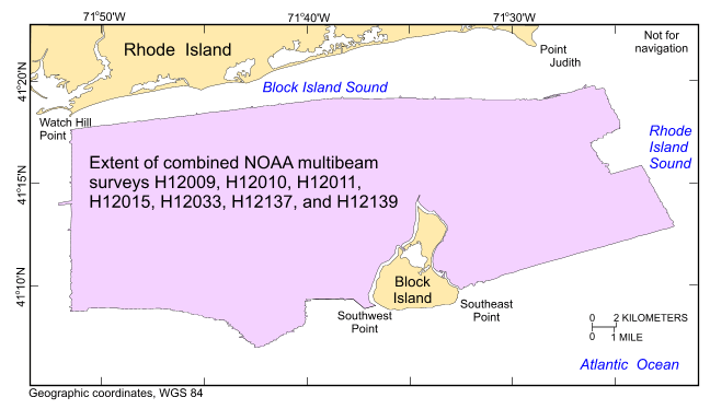
To release an outline of the combined multibeam bathymetry generated from NOAA surveys H12009, H12010, H12011, H12015, H12033, H12137, and H12139 offshore in Block Island Sound in geographic, WGS84.

How was the data set created?

  1. From what previous works were the data drawn?
    Information unavailable from original metadata. (source 1 of 7)
    Schattgen, P. Tod, and Atlantic Hydrographic Branch, National Ocean Survey, National Oceanic and Atmospheric Administration, Unpublished Material, H12009.

    Type_of_Source_Media: computer harddrive
    Source_Contribution: Original processed multibeam bathymetric data.
    Information unavailable from original metadata. (source 2 of 7)
    Smith, Shepard M., and Atlantic Hydrographic Branch, National Ocean Survey, National Oceanic and Atmospheric Administration, Unpublished Material, H12010.

    Type_of_Source_Media: computer harddrive
    Source_Contribution: Original processed multibeam bathymetric data.
    Information unavailable from original metadata. (source 3 of 7)
    Smith, Shepard M., and Atlantic Hydrographic Branch, National Ocean Survey, National Oceanic and Atmospheric Administration, Unpublished Material, H12011.

    Type_of_Source_Media: computer harddrive
    Source_Contribution: Original processed multibeam bathymetric data.
    Information unavailable from original metadata. (source 4 of 7)
    Smith, Shepard M., and Atlantic Hydrographic Branch, National Ocean Survey, National Oceanic and Atmospheric Administration, Unpublished Material, H12015.

    Type_of_Source_Media: computer harddrive
    Source_Contribution: Original processed multibeam bathymetric data.
    Information unavailable from original metadata. (source 5 of 7)
    Smith, Shepard M., and Atlantic Hydrographic Branch, National Ocean Survey, National Oceanic and Atmospheric Administration, Unpublished Material, H12033.

    Type_of_Source_Media: computer harddrive
    Source_Contribution: Original processed multibeam bathymetric data.
    Information unavailable from original metadata. (source 6 of 7)
    Smith, Shepard M., and Atlantic Hydrographic Branch, National Ocean Survey, National Oceanic and Atmospheric Administration, Unpublished Material, H12137.

    Type_of_Source_Media: computer harddrive
    Source_Contribution: Original processed multibeam bathymetric data.
    Information unavailable from original metadata. (source 7 of 7)
    Smith, Shepard M., and Atlantic Hydrographic Branch, National Ocean Survey, National Oceanic and Atmospheric Administration, Unpublished Material, H12139.

    Type_of_Source_Media: computer harddrive
    Source_Contribution: Original processed multibeam bathymetric data.
  2. How were the data generated, processed, and modified?
    Date: 2011 (process 1 of 6)
    The GeoTIFF image of the combined multibeam bathymetry from NOAA surveys H12009, H12010, H12011, H12015, H12033, H12137, and H12139 was imported into the ArcView 3.3 GIS project view. These acoustic data were outlined using the available graphic tools then converted to a polygon shapefile using ArcView 3.3. Person who carried out this activity:
    Larry Poppe
    U.S. Geological Survey
    Geologist
    384 Woods Hole Road
    Woods Hole, MA

    508-548-8700 x2314 (voice)
    508-457-2310 (FAX)
    lpoppe@usgs.gov
    Data sources used in this process:
    • bisound_4mbat_geo.tif
    Data sources produced in this process:
    • bisound_outline.shp
    Date: 2011 (process 2 of 6)
    ArcGIS 9.2 was used to define the projection as geographic WGS84 of the ESRI shapefile and to create the .prj file using the ArcToolbox Define Projection tool. XTools was used to calculate the area based on UTM Zone 19, WGS84 (UTM to get a more accurate area and WGS84 so the data were not reprojected during the calculation). Person who carried out this activity:
    Larry Poppe
    U.S. Geological Survey
    Geologist
    384 Woods Hole Road
    Woods Hole, MA
    USA

    508-548-8700 x2314 (voice)
    508-457-2310 (FAX)
    lpoppe@usgs.gov
    Data sources used in this process:
    • bisound_outline.shp
    Data sources produced in this process:
    • bisound_outline.prj
    Date: 07-Dec-2015 (process 3 of 6)
    Edits to the metadata were made to fix any errors that MP v 2.9.32 flagged. This is necessary to enable the metadata to be successfully harvested for various data catalogs. In some cases, this meant adding text "Information unavailable" or "Information unavailable from original metadata" for those required fields that were left blank. Other minor edits were probably performed (title, publisher, publication place, etc.). The metadata date (but not the metadata creator) was edited to reflect the date of these changes. The metadata available from a harvester may supersede metadata bundled within a download file. Compare the metadata dates to determine which metadata file is most recent. Person who carried out this activity:
    U.S. Geological Survey
    Attn: VeeAnn A. Cross
    Marine Geologist
    384 Woods Hole Rd
    Woods Hole, MA

    508-548-8700 x2251 (voice)
    508-457-2310 (FAX)
    vatnipp@usgs.gov
    Date: 20-Jul-2018 (process 4 of 6)
    USGS Thesaurus keywords added to the keyword section. Person who carried out this activity:
    U.S. Geological Survey
    Attn: VeeAnn A. Cross
    Marine Geologist
    384 Woods Hole Road
    Woods Hole, MA

    508-548-8700 x2251 (voice)
    508-457-2310 (FAX)
    vatnipp@usgs.gov
    Date: 18-Nov-2019 (process 5 of 6)
    Crossref DOI link was added as the first link in the metadata. Person who carried out this activity:
    U.S. Geological Survey
    Attn: VeeAnn A. Cross
    Marine Geologist
    384 Woods Hole Road
    Woods Hole, MA

    508-548-8700 x2251 (voice)
    508-457-2310 (FAX)
    vatnipp@usgs.gov
    Date: 08-Sep-2020 (process 6 of 6)
    Added keywords section with USGS persistent identifier as theme keyword. Person who carried out this activity:
    U.S. Geological Survey
    Attn: VeeAnn A. Cross
    Marine Geologist
    384 Woods Hole Road
    Woods Hole, MA

    508-548-8700 x2251 (voice)
    508-457-2310 (FAX)
    vatnipp@usgs.gov
  3. What similar or related data should the user be aware of?
    Schattgen, P. Tod, 2009, H12009: Descriptive Report H12009, National Ocean Survey, National Oceanic and Atmospheric Administration, Atlantic Hydrographic Branch, Norfolk, VA.

    Online Links:

    Smith, Shepard M., 2009, H12010: Descriptive Report H12010, National Ocean Survey, National Oceanic and Atmospheric Administration, Atlantic Hydrographic Branch, Norfolk, VA.

    Online Links:

    Smith, Shepard M., 2009, H12011: Descriptive Report H12011, National Ocean Survey, National Oceanic and Atmospheric Administration, Atlantic Hydrographic Branch, Norfolk, VA.

    Online Links:

    Smith, Shepard M., 2009, H12015: Descriptive Report H12015, National Ocean Survey, National Oceanic and Atmospheric Administration, Atlantic Hydrographic Branch, Norfolk, VA.

    Online Links:

    Smith, Shepard M., 2009, H12033: Descriptive Report H12033, National Ocean Survey, National Oceanic and Atmospheric Administration, Atlantic Hydrographic Branch, Norfolk, VA.

    Online Links:

    Smith, Shepard M., 2009, H12137: Descriptive Report H12137, National Ocean Survey, National Oceanic and Atmospheric Administration, Atlantic Hydrographic Branch, Norfolk, VA.

    Online Links:

    Smith, Shepard M., 2009, H12139: Descriptive Report H12139, National Ocean Survey, National Oceanic and Atmospheric Administration, Atlantic Hydrographic Branch, Norfolk, VA.

    Online Links:

    McMullen, K.Y., Poppe, L.J., Ackerman, S.D., Blackwood, D.S., Schaer, J.D., Nadeau, M.A., and Wood, D.A., 2011, Surficial geology of the sea floor in central Rhode Island Sound southeast of Point Judith, Rhode Island: Open-File Report 2011-1005, U.S. Geological Survey, Reston, VA.

    Online Links:

    Other_Citation_Details: 1 DVD-ROM
    Poppe, L.J., McMullen, K.Y., Ackerman, S.D., Blackwood, D.S., Irwin, B.J., Schaer, J.D., and Forrest, M.R., 2011, Sea-floor geology and character of eastern Rhode Island Sound west of Gay Head, Massachusetts: Open-File Report 2011-1004, U.S. Geological Survey, Reston, VA.

    Online Links:

    Other_Citation_Details: 1 DVD-ROM
    McMullen, K.Y., Poppe, L.J., Denny, J.F., Haupt, T.A., and Crocker, J.M., 2008, Sidescan-sonar imagery and surficial geologic interpretation of the sea-floor in central Rhode Island Sound: Open-File Report 2007-1366, U.S. Geological Survey, Reston, VA.

    Online Links:

    Other_Citation_Details: 1 DVD-ROM
    McMullen, K.Y., Poppe, L.J., Haupt, T.A., and Crocker, J.M., 2009, Sidescan-Sonar Imagery and Surficial Geologic Interpretations of the Sea Floor in Western Rhode Island Sound: Open-File Report 2008-1181, U.S. Geological Survey, Reston, VA.

    Online Links:

    Other_Citation_Details: 1 DVD-ROM

How reliable are the data; what problems remain in the data set?

  1. How well have the observations been checked?
  2. How accurate are the geographic locations?
    Horizontal position of the launches acquiring multibeam bathymetry were determined using GPS corrected by U.S. Coast Guard differential GPS beacon stations at Moriches, NY and Acushnet, MA. The final CARIS combined base surfaces for the MBES data were produced at a 2-m cell size.
  3. How accurate are the heights or depths?
  4. Where are the gaps in the data? What is missing?
    This data layer shows the extent and location of the combined bathymetry data collected during NOAA surveys H12009, H12010, H12011, H12015, H12033, H12137, and H12139.
  5. How consistent are the relationships among the observations, including topology?
    No additional checks for consistency were performed on this data.

How can someone get a copy of the data set?

Are there legal restrictions on access or use of the data?
Access_Constraints: None
Use_Constraints:
Public domain data are freely redistributable with proper metadata and source attribution. Please recognize the U.S. Geological Survey (USGS) as the originator of this information.
  1. Who distributes the data set? (Distributor 1 of 1)
    Larry Poppe
    U.S. Geological Survey
    Geologist
    384 Woods Hole Road
    Woods Hole, MA

    508-548-8700 x2314 (voice)
    508-457-2310 (FAX)
    lpoppe@usgs.gov
  2. What's the catalog number I need to order this data set? Downloadable Data
  3. What legal disclaimers am I supposed to read?
    Neither the U.S. Government, the Department of the Interior, nor the USGS, nor the National Oceanic and Atmospheric Administration (NOAA), nor any of their employees, contractors, or subcontractors, make any warranty, express or implied, nor assume any legal liability or responsibility for the accuracy, completeness, or usefulness of any information, apparatus, product, or process disclosed, nor represent that its use would not infringe on privately owned rights. The act of distribution shall not constitute any such warranty, and no responsibility is assumed by the USGS or NOAA in the use of these data or related materials. Any use of trade, product, or firm names is for descriptive purposes only and does not imply endorsement by the U.S. Government.
  4. How can I download or order the data?
  5. What hardware or software do I need in order to use the data set?
    These data are available in Environmental Systems Research Institute (ESRI) shapefile format. The user must have ArcGIS or ArcView 3.0 or greater software to read and process the data file. In lieu of ArcView or ArcGIS, the user may utilize another GIS application package capable of importing data. A free data viewer, ArcExplorer, capable of displaying the data is available from ESRI at www.esri.com. The user must have software capable of uncompressing archived zip files, such as WinZip or Pkware.

Who wrote the metadata?

Dates:
Last modified: 16-Nov-2021
Metadata author:
U.S. Geological Survey
Attn: Larry Poppe
Geologist
384 Woods Hole Road
Woods Hole, MA

508-548-8700 x2314 (voice)
508-457-2310 (FAX)
whsc_data_contact@usgs.gov
Contact_Instructions:
The metadata contact email address is a generic address in the event the metadata contact is no longer with the USGS or the email is otherwise invalid.
Metadata standard:
FGDC Content Standards for Digital Geospatial Metadata (FGDC-STD-001-1998)

This page is <https://cmgds.marine.usgs.gov/catalog/whcmsc/open_file_report/ofr2012-1005/bisound_outline.shp.faq.html>
Generated by mp version 2.9.50 on Tue Nov 16 10:06:46 2021