Online Links:
Online Links:
| Value | Definition |
|---|---|
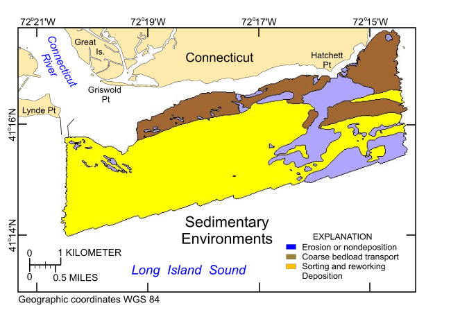
| Erosion or Nondeposition | High-energy environment within which sea-floor sediments are either removed or do not accumulate. Examples of features used to identify this sedimentary environment include: scour depressions, obstacle marks, and rocky outcrops in the multibeam bathymetry; high backscatter targets and areas of high backscatter in the sidescan sonar; gravel, boulders, and bedrock outcrops in the photography; and gravel in the sediment samples. |
| Coarse Bedload Transport | Environment within which sea-floor sand and pea-gravel sized sediments are transported. Examples of features used to identify this sedimentary environment include: subaqueous dunes (i.e. sand waves and megaripples) in the multibeam bathymetry; moderate backscatter in the sidescan sonar; current rippled sand in the photography; and clean sand and fine gravel in the sediment samples. |
| Sorting and Reworking | Environment within which sea-floor sediments are being separated into coarser and finer fractions. Examples of features used to identify this sedimentary environment include: relatively flat, featureless seabed in the multibeam bathymetry; areas of lower backscatter in the sidescan sonar; faintly rippled to undulating seabed and scattered shell accumulations in the photography; and fine-grained, slightly muddy sediment samples. |
To release an interpretation of sedimentary environments based on bathymetry data collected during NOAA survey H12013 and sediment samples and bottom photography collected during USGS surveys 2009-059-FA and 2010-010-FA in eastern Long Island Sound, in a geographic, WGS84 coordinate system. These data can be used to provide information on surface geology and sedimentary processes.
Online Links:
Online Links:
Online Links:
Online Links:
Online Links:
Online Links:
Online Links:
Are there legal restrictions on access or use of the data?Access_Constraints: None
Use_Constraints:The interpretation was completed at map scales between 1:4,000 and 1:5,000, but is not intended for use at map scales smaller than 1:24,000. Public domain data from the U.S. Government are freely redistributable with proper metadata and source attribution. Please recognize the U.S. Geological Survey (USGS) as the source of this information.
Neither the U.S. Government, the Department of the Interior, nor the USGS, nor the National Oceanic and Atmospheric Administration (NOAA), nor the Connecticut Department of Energy and Environmental Protection (CT DEEP) nor any of their employees, contractors, or subcontractors, make any warranty, express or implied, nor assume any legal liability or responsibility for the accuracy, completeness, or usefulness of any information, apparatus, product, or process disclosed, nor represent that its use would not infringe on privately owned rights. The act of distribution shall not constitute any such warranty, and no responsibility is assumed by the USGS, NOAA, or the CT DEEP in the use of these data or related materials. Any use of trade, product, or firm names is for descriptive purposes only and does not imply endorsement by the U.S. Government.
| Data format: | A zip file containing the geospatial data, metadata, and browse graphic. in format SHP (version ArcView 3.3) ESRI polygon shapefile Size: 0.15 |
|---|---|
| Network links: |
http://pubs.usgs.gov/of/2012/1103/data/sedenv/h12013_sedenv.zip http://pubs.usgs.gov/of/2012/1103/data/sedenv/ http://pubs.usgs.gov/of/2012/1103/html/catalog.html |
| Media you can order: | DVD-ROM (Density 4.7 Gbytes) (format UDF) |
The user must be capable of uncompressing WinZip files. Also, these data are available in Environmental Systems Research Institute (ESRI) shapefile format. The user must have ArcGIS or ArcView 3.0 or greater software to read and process the data file. In lieu of ArcView or ArcGIS, the user may utilize another GIS application package capable of importing data. A free data viewer, ArcExplorer, capable of displaying the data is available from ESRI at www.esri.com.