Locations of Sea-Floor Photographs Acquired During U.S. Geological Survey (USGS) Cruise 2010-015-FA Offshore in Northeastern Long Island Sound (Geographic, WGS84, H12012_BOTPHOTOS.SHP)

Metadata also available as - [Outline] - [Parseable text] - [XML]

Frequently anticipated questions:


What does this data set describe?

Title:
Locations of Sea-Floor Photographs Acquired During U.S. Geological Survey (USGS) Cruise 2010-015-FA Offshore in Northeastern Long Island Sound (Geographic, WGS84, H12012_BOTPHOTOS.SHP)
Abstract:
The U.S. Geological Survey (USGS), in cooperation with the National Oceanic and Atmospheric Administration (NOAA) and the Connecticut Department of Energy and Environmental Protection (CT DEEP), has produced detailed geologic maps of the coastal sea floor. Bathymetry, originally collected by NOAA for charting purposes, provides a fundamental framework for research and management activities in Long Island Sound, shows the terrain of the seabed, and provides information on sediment transport and benthic habitat. During April 2009 NOAA completed hydrographic survey H12012 offshore in the northeastern Sound, and during April 2010 and May 2010 bottom photographs and surficial sediment data were acquired as part of two ground-truth reconnaissance surveys of this area. Two interpretive data layers were derived from the multibeam echo-sounder and the ground-truth data used to verify them. For more information on the ground-truth surveys see: https://cmgds.marine.usgs.gov/fan_info.php?fan=2010-010-FA and https://cmgds.marine.usgs.gov/fan_info.php?fan=2010-015-FA.
  1. How might this data set be cited?
    Poppe, Larry, 2013, Locations of Sea-Floor Photographs Acquired During U.S. Geological Survey (USGS) Cruise 2010-015-FA Offshore in Northeastern Long Island Sound (Geographic, WGS84, H12012_BOTPHOTOS.SHP): Open-File Report 2013-1060, U.S. Geological Survey, Coastal and Marine Geology Program, Woods Hole Coastal and Marine Science Center, Woods Hole, MA.

    Online Links:

    This is part of the following larger work.

    Poppe, L.J., McMullen, K.Y., Ackerman, S.D., and Glomb, K.A., 2013, Sea-Floor Geology and Topography Offshore in Northeastern Long Island Sound: Open-File Report 2013-1060, U.S. Geological Survey, Reston, VA.

    Online Links:

    Other_Citation_Details: Also available on DVD-ROM
  2. What geographic area does the data set cover?
    West_Bounding_Coordinate: -72.400539
    East_Bounding_Coordinate: -72.164670
    North_Bounding_Coordinate: 41.258060
    South_Bounding_Coordinate: 41.200302
  3. What does it look like?
    https://pubs.usgs.gov/of/2013/1060/data/botphotos/h12012_botphotos.gif (GIF)
    Thumbnail image showing location and extent of bottom photo locations offshore in northeastern Long Island Sound
  4. Does the data set describe conditions during a particular time period?
    Beginning_Date: 25-May-2010
    Ending_Date: 26-May-2010
    Currentness_Reference:
    ground condition; there were actually two days of photographic data collection: 20100525 and 20100526
  5. What is the general form of this data set?
    Geospatial_Data_Presentation_Form: vector digital data
  6. How does the data set represent geographic features?
    1. How are geographic features stored in the data set?
      This is a Vector data set. It contains the following vector data types (SDTS terminology):
      • Entity point (64)
    2. What coordinate system is used to represent geographic features?
      Horizontal positions are specified in geographic coordinates, that is, latitude and longitude. Latitudes are given to the nearest 0.000001. Longitudes are given to the nearest 0.000001. Latitude and longitude values are specified in Decimal degrees. The horizontal datum used is D_WGS_1984.
      The ellipsoid used is WGS_1984.
      The semi-major axis of the ellipsoid used is 6378137.000000.
      The flattening of the ellipsoid used is 1/298.257224.
  7. How does the data set describe geographic features?
    h12012_botphotos
    Shapefile Attribute Table (Source: ESRI)
    FID
    Internal feature number. (Source: Esri) Sequential unique whole numbers that are automatically generated.
    Shape
    Feature geometry. (Source: Esri) Coordinates defining the features.
    STATION
    Sequential identifier assigned to each sample site (Source: USGS) Characters and numerics identifying sampling sites
    PHOTO
    Sequential identifier assigned to each photograph (Source: USGS) Characters and numerics identifying photos. Combination of station and photo number.
    DATE
    Month, day, and year when the photograph was taken (Source: USGS) Character String: Months, days, and year as m/dd/yyyy
    LATITUDE
    Latitude coordinate of photo location, WGS84 (Source: USGS)
    Range of values
    Minimum:41.200302
    Maximum:41.25806
    Units:Decimal degrees
    Resolution:0.000001
    LONGITUDE
    Longitude coordinate of photo location, WGS84 (Source: USGS)
    Range of values
    Minimum:-72.400539
    Maximum:-72.16467
    Units:Decimal degrees
    Resolution:0.000001
    DEVICE
    Equipment used to collect the photograph (Source: USGS)
    ValueDefinition
    MID-SIZED SEABOSS GRABMid-sized USGS Seabed Observation and Sampling System (SEABOSS)
    CRUISEID
    Cruise identifier (Source: USGS) 2010-015-FA
    PROJECTID
    Name of project for which the photographs were taken. (Source: USGS)
    ValueDefinition
    SURVEY H12012 IN LONG ISLAND SOUNDProject name assigned by scientist
    PRINCIPAL
    Name of Chief scientist during the cruise (Source: USGS)
    ValueDefinition
    LPOPPELarry Poppe
    JDTIME
    Date and time when photo were taken in the format JJJ:HH:MM:SS where JJJ is the Julian day, HH is the hour, MM iss the minute, and SS is the second. Time is in GMT. (Source: Scientist) Numerics separated by colons
    Entity_and_Attribute_Overview:
    Data layer attributes include date, time and position photograph was acquired, station and photograph identifiers for photographs collected within the study area during USGS cruise 2010-015-FA aboard the OSV Bold.
    Entity_and_Attribute_Detail_Citation: U.S. Geological Survey

Who produced the data set?

  1. Who are the originators of the data set? (may include formal authors, digital compilers, and editors)
    • Larry Poppe
  2. Who also contributed to the data set?
  3. To whom should users address questions about the data?
    Larry Poppe
    U.S. Geological Survey
    Geologist
    384 Woods Hole Road
    Woods Hole, MA
    USA

    (508) 548-8700 x2314 (voice)
    (508) 457-2310 (FAX)
    lpoppe@usgs.gov

Why was the data set created?

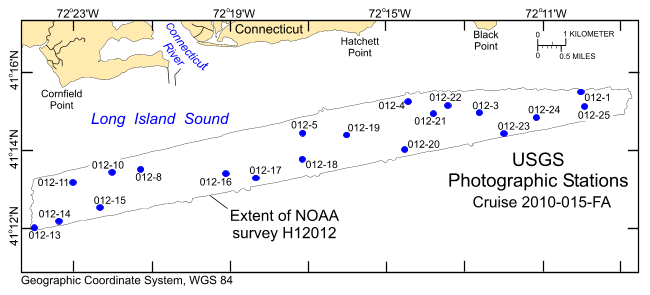
The purpose of this dataset is to release the locations and identifiers of 64 photographs from the sea floor collected at 20 stations on bathymetry data from offshore in northeastern Long Island Sound in geographic, WGS84.

How was the data set created?

  1. From what previous works were the data drawn?
  2. How were the data generated, processed, and modified?
    Date: 2013 (process 1 of 6)
    GPS Navigation (degrees with decimal minutes to six places) and time updated every second were recorded and correlated with the times manually recorded in the SEABOSS log to register the still photographs. These locations were checked against the navigation on the videotape (degrees with decimal minutes to three places) and in cruise logs for verification; there was little offset. This information was manually input into an Excel 2003 (.xls) file and exported to create an ASCII file of this information. Shapefiles were created in ArcView 3.3 from the ASCII comma-delimited files by creating an Event Theme and then converting it to a shapefile. Person who carried out this activity:
    Larry Poppe
    U.S. Geological Survey
    Geologist
    384 Woods Hole Road
    Woods Hole, MA
    USA

    (508) 548-8700 x2314 (voice)
    (508) 457-2310 (FAX)
    lpoppe@usgs.gov
    Data sources used in this process:
    • h12012_botphotos.xls
    • h12012_botphotos.txt
    Data sources produced in this process:
    • h12012_botphotos.shp
    Date: 2013 (process 2 of 6)
    ArcGIS 9.2 was used to define the projection of the Esri shapefile as geographic WGS84 using ArcToolbox - Data Management Tools - Projections and Transformations - Define Projection. Person who carried out this activity:
    Larry Poppe
    U.S. Geological Survey
    Geologist
    384 Woods Hole Road
    Woods Hole, MA
    USA

    508-548-8700 x2314 (voice)
    508-457-2310 (FAX)
    lpoppe@usgs.gov
    Data sources used in this process:
    • h12012_botphotos.shp
    Data sources produced in this process:
    • h12012_botphotos.prj
    Date: 10-Oct-2017 (process 3 of 6)
    Edits to the metadata were made to fix any errors that MP v 2.9.36 flagged. This is necessary to enable the metadata to be successfully harvested for various data catalogs. In some cases, this meant adding text "Information unavailable" or "Information unavailable from original metadata" for those required fields that were left blank. Other minor edits were probably performed (title, publisher, publication place, etc.). Attempted to modify http to https where appropriate. Updated the field activity link. The source information only had time period of content, so the element was removed. Instead of 3 distribution sections, made it 1 distribution section with 3 distribution forms. The metadata date (but not the metadata creator) was edited to reflect the date of these changes. The metadata available from a harvester may supersede metadata bundled within a download file. Compare the metadata dates to determine which metadata file is most recent. Person who carried out this activity:
    U.S. Geological Survey
    Attn: VeeAnn A. Cross
    Marine Geologist
    384 Woods Hole Road
    Woods Hole, MA

    508-548-8700 x2251 (voice)
    508-457-2310 (FAX)
    vatnipp@usgs.gov
    Date: 20-Jul-2018 (process 4 of 6)
    USGS Thesaurus keywords added to the keyword section. Person who carried out this activity:
    U.S. Geological Survey
    Attn: VeeAnn A. Cross
    Marine Geologist
    384 Woods Hole Road
    Woods Hole, MA

    508-548-8700 x2251 (voice)
    508-457-2310 (FAX)
    vatnipp@usgs.gov
    Date: 18-Nov-2019 (process 5 of 6)
    Crossref DOI link was added as the first link in the metadata. Person who carried out this activity:
    U.S. Geological Survey
    Attn: VeeAnn A. Cross
    Marine Geologist
    384 Woods Hole Road
    Woods Hole, MA

    508-548-8700 x2251 (voice)
    508-457-2310 (FAX)
    vatnipp@usgs.gov
    Date: 08-Sep-2020 (process 6 of 6)
    Added keywords section with USGS persistent identifier as theme keyword. Person who carried out this activity:
    U.S. Geological Survey
    Attn: VeeAnn A. Cross
    Marine Geologist
    384 Woods Hole Road
    Woods Hole, MA

    508-548-8700 x2251 (voice)
    508-457-2310 (FAX)
    vatnipp@usgs.gov
  3. What similar or related data should the user be aware of?
    Blackwood, D., and Parolski, K., 2001, Seabed observation and sampling system: Sea Technology v. 42, no. 2, p. 39-43.

    Poppe, L.J., DiGiacomo-Cohen, M.L., Doran, E.F., Smith, S.M., Stewart, H.F., and Forfinski, N.A., 2007, Geologic interpretation and multibeam bathymetry of the sea floor in the vicinity of the Race, eastern Long Island Sound: Open-File Report 2007-1012, U.S. Geological Survey, Reston, VA.

    Online Links:

    Poppe, L.J., Denny, J.F., Williams, S.J., Moser, M.S., Forfinski, N.A., Stewart, H.F., and Doran, E.F., 2007, The geology of Six Mile Reef, eastern Long Island Sound: Open-File Report 2007-1191, U.S. Geological Survey, Reston, VA.

    Online Links:

    McMullen, K.Y., Poppe, L.J., Danforth, W.W., Blackwood, D.S., Schaer, J.D., Ostapenko, A.J., Glomb, K.A., and Doran, E.F., 2010, Surficial geology of the sea floor in Long Island Sound offshore of Plum Island, New York: Open-File Report 2010-1005, U.S. Geological Survey, Reston, VA.

    Online Links:

    Poppe, L.J., McMullen, K.Y., Ackerman, D.S., Blackwood, D.S., Irwin, B.J., Schaer, J.D., Lewit, P.G., and Doran, E.F., 2010, Sea-floor geology and character offshore of Rocky Point, New York: Open-File Report 2010-1007, U.S. Geological Survey, Reston, VA.

    Online Links:

    Other_Citation_Details: 1 DVD-ROM
    McMullen, K.Y., Poppe, L.J., Danforth, W.W., Blackwood, D.S., Schaer, J.D., Guberski, M.R., Wood, D.A., and Doran, E.F., 2011, Surficial geology of the sea floor in Long Island Sound offshore of Orient Point, New York: Open-File Report 2010-1100, U.S. Geological Survey, Reston, VA.

    Online Links:

    Other_Citation_Details: 1 DVD-ROM
    Poppe, L.J., McMullen, K.Y., Ackerman, S.D., Blackwood, D.S., Schaer, J.D., Forrest, M.R., Ostapenko, A.J., and Doran, E.F., 2011, Sea-floor geology and topography offshore in eastern Long Island Sound: Open-File Report 2010-1150, U.S. Geological Survey, Reston, VA.

    Online Links:

    Other_Citation_Details: 1 DVD-ROM
    McMullen, K.Y., Poppe, L.J., Danforth, W.W., Blackwood, D.S., Schaer, J.D., Glomb, K.A., and Doran, E.F., 2012, Sea-floor geology of Long Island Sound north of Duck Pond Point, New York: Open-File Report 2011-1149, U.S. Geological Survey, Reston, VA.

    Online Links:

    Other_Citation_Details: 1 DVD-ROM
    Poppe, L.J., McMullen, K.Y., Ackerman, S.D., Guberski, M.R., and Wood, D.A., 2013, Sea-floor character and geology off the entrance to the Connecticut River, northeastern Long Island Sound: Open-File Report 2013-1060, U.S. Geological Survey, Reston, VA.

    Online Links:

    Other_Citation_Details: 1 DVD-ROM

How reliable are the data; what problems remain in the data set?

  1. How well have the observations been checked?
    All attributes were checked in a consistent manner
  2. How accurate are the geographic locations?
    Navigation was by differential GPS. Although GPS gave the ship's position rather than that of the SEABOSS, the antenna was located less than 5 m from the block on the A-frame, water depths were generally shallow, and scope of the cable minimal. Therefore, SEABOSS offset from the antenna was less than 10 m.
  3. How accurate are the heights or depths?
  4. Where are the gaps in the data? What is missing?
    Locations of all still photographs of the sea floor collected within the study area during the OSV Bold cruise 2010-015-FA were included in this data set. Total station numbers range from 012-1 to 012-25, but there are no stations 012-2, 012-7, 012-9 and 012-12 due to weather. No still photos were taken at 012-6 because of extreme turbidity.
  5. How consistent are the relationships among the observations, including topology?
    No additional checks for topological consistency were performed on this data.

How can someone get a copy of the data set?

Are there legal restrictions on access or use of the data?
Access_Constraints: None
Use_Constraints:
Public domain data from the U.S. government are freely redistributable with proper metadata and source attribution. Please recognize the U.S. Geological Survey (USGS) as the source of this information.
  1. Who distributes the data set? (Distributor 1 of 1)
    Larry Poppe
    U.S. Geological Survey
    Geologist
    384 Woods Hole Road
    Woods Hole, MA
    USA

    (508) 548-8700 x2314 (voice)
    (508) 457-2310 (FAX)
    lpoppe@usgs.gov
  2. What's the catalog number I need to order this data set? Downloadable Data
  3. What legal disclaimers am I supposed to read?
    Neither the U.S. Government, the Department of the Interior, nor the USGS, nor the National Oceanic and Atmospheric Administration (NOAA), nor the Connecticut Department of Energy and Environmental Protection (CT DEEP) nor any of their employees, contractors, or subcontractors, make any warranty, express or implied, nor assume any legal liability or responsibility for the accuracy, completeness, or usefulness of any information, apparatus, product, or process disclosed, nor represent that its use would not infringe on privately owned rights. The act of distribution shall not constitute any such warranty, and no responsibility is assumed by the USGS, NOAA, or the CT DEEP in the use of these data or related materials. Any use of trade, product, or firm names is for descriptive purposes only and does not imply endorsement by the U.S. Government.
  4. How can I download or order the data?
  5. What hardware or software do I need in order to use the data set?
    These data are available in Environmental Systems Research Institute (Esri) shapefile format. The user must have ArcGIS or ArcView 3.0 or greater software to read and process the data file. In lieu of ArcView or ArcGIS, the user may utilize another GIS application package capable of importing data. A free data viewer, ArcExplorer, capable of displaying the data is available from Esri at www.esri.com. The user must have software capable of uncompressing archived zip files, such as Winzip or Pkware. The Excel (2003) and TEXT versions of the data are also available in the WinZip file.

Who wrote the metadata?

Dates:
Last modified: 16-Nov-2021
Metadata author:
Larry Poppe
U.S. Geological Survey
Geologist
384 Woods Hole Road
Woods Hole, MA
USA

(508) 548-8700 x2314 (voice)
(508) 457-2310 (FAX)
whsc_data_contact@usgs.gov
Contact_Instructions:
The metadata contact email address is a generic address in the event the metadata contact is no longer with the USGS or the email is otherwise invalid.
Metadata standard:
FGDC Content Standards for Digital Geospatial Metadata (FGDC-STD-001-1998)

This page is <https://cmgds.marine.usgs.gov/catalog/whcmsc/open_file_report/ofr2013-1060/h12012_botphotos_md.faq.html>
Generated by mp version 2.9.50 on Tue Nov 16 10:06:51 2021