Color Shaded-Relief GeoTIFF Image Showing the Combined 4-m Multibeam Bathymetry Generated from National Oceanic and Atmospheric Administration (NOAA) Surveys H11922, H11995, H11996, H12009, H12010, H12011, H12015, H12023, H12033, H12137, H12139, H12296, H12298, and H12299 Offshore in Rhode Island and Block Island Sounds (RICOMB_4MMB_GEO.TIF, Geographic, WGS 84)

Metadata also available as - [Outline] - [Parseable text] - [XML]

Frequently anticipated questions:


What does this data set describe?

Title:
Color Shaded-Relief GeoTIFF Image Showing the Combined 4-m Multibeam Bathymetry Generated from National Oceanic and Atmospheric Administration (NOAA) Surveys H11922, H11995, H11996, H12009, H12010, H12011, H12015, H12023, H12033, H12137, H12139, H12296, H12298, and H12299 Offshore in Rhode Island and Block Island Sounds (RICOMB_4MMB_GEO.TIF, Geographic, WGS 84)
Abstract:
Detailed bathymetric maps of the sea floor in Block Island and Rhode Island Sounds are of great interest to the New York, Rhode Island, and Massachusetts research and management communities because of this area's ecological, recreational, and commercial importance. Geologically interpreted digital terrain models (DTMs) from individual surveys provide important benthic environmental information, yet many applications require a geographically broader perspective. For example, individual surveys are of limited use for the planning and construction of cross-sound infrastructure, such as cables and pipelines, or for the testing of regional circulation models. To address this need, we integrated 14 contiguous multibeam bathymetric DTMs, produced by the National Oceanic and Atmospheric Administration during charting operations, into one dataset that covers much of Block Island Sound and extends eastward across Rhode Island Sound. The new dataset, which covers over 1255 square kilometers, is adjusted to mean lower low water, is gridded to 4-meter resolution, and is provided in UTM Zone 19 NAD 83 and geographic WGS 84 projections. This resolution is adequate for sea-floor feature and process interpretation but is small enough to be queried and manipulated with standard Geographic Information System programs and to allow for future growth. Natural features visible in the grid include boulder lag deposits of winnowed Pleistocene strata, sand-wave fields, and scour depressions that reflect the strength of the oscillating and asymmetric tidal currents and scour by storm-induced waves. Bedform asymmetry allows interpretations of net sediment transport. Together the merged data reveal a larger, more continuous perspective of bathymetric topography than previously available, providing a fundamental framework for research and resource management activities off the Rhode Island coast.
  1. How might this data set be cited?
    National Oceanic and Atmospheric Administration, and U.S. Geological Survey, 2014, Color Shaded-Relief GeoTIFF Image Showing the Combined 4-m Multibeam Bathymetry Generated from National Oceanic and Atmospheric Administration (NOAA) Surveys H11922, H11995, H11996, H12009, H12010, H12011, H12015, H12023, H12033, H12137, H12139, H12296, H12298, and H12299 Offshore in Rhode Island and Block Island Sounds (RICOMB_4MMB_GEO.TIF, Geographic, WGS 84): Open-File Report 2014-1012, U.S. Geological Survey, Coastal and Marine Geology Program, Woods Hole Coastal and Marine Science Center, Woods Hole, MA.

    Online Links:

    This is part of the following larger work.

    Poppe, L.J., McMullen, K.Y., Danforth, W.W., Blankenship, M.A., Clos, A.R., Glomb, K.A., Lewit, P.G., Nadeau, M.A., D.A.Wood, and Parker, C.E., 2014, Combined Multibeam Bathymetry Data from Rhode Island Sound and Block Island Sound - A Regional Perspective: Open-File Report 2014-1012, U.S. Geological Survey, Reston, VA.

    Online Links:

    Other_Citation_Details: 1 DVD-ROM
  2. What geographic area does the data set cover?
    West_Bounding_Coordinate: -72.126425
    East_Bounding_Coordinate: -70.839675
    North_Bounding_Coordinate: 41.403616
    South_Bounding_Coordinate: 41.096701
  3. What does it look like?
    http://pubs.usgs.gov/of/2014/1012/data/bathy/geotifs/geo/ricomb_4mmb_geo.gif (GIF)
    Browse image of a 4-m hill-shaded GeoTIFF of the combined bathymetry from NOAA surveys H11922, H11995, H11996, H12009, H12010, H12011, H12015, H12023, H12033, H12137, H12139, H12296, H12298, and H12299 offshore in Rhode Island and Block Island Sounds in geographic, WGS84 coordinates.
  4. Does the data set describe conditions during a particular time period?
    Beginning_Date: 16-Jul-2008
    Ending_Date: 16-Nov-2011
    Currentness_Reference:
    ground condition (See the source citation in the lineage section for individual component's specific dates.)
  5. What is the general form of this data set?
    Geospatial_Data_Presentation_Form: remote-sensing image
  6. How does the data set represent geographic features?
    1. How are geographic features stored in the data set?
      This is a Raster data set. It contains the following raster data types:
      • Dimensions 7038 x 29507 x 1, type Pixel
    2. What coordinate system is used to represent geographic features?
      Horizontal positions are specified in geographic coordinates, that is, latitude and longitude. Latitudes are given to the nearest 0.000043. Longitudes are given to the nearest 0.000043. Latitude and longitude values are specified in Decimal degrees. The horizontal datum used is D_WGS_1984.
      The ellipsoid used is WGS_1984.
      The semi-major axis of the ellipsoid used is 6378137.000000.
      The flattening of the ellipsoid used is 1/298.257224.
  7. How does the data set describe geographic features?
    Entity_and_Attribute_Overview:
    A color-encoded hill-shaded GeoTIFF of the combined bathymetry data from NOAA surveys H11922, H11995, H11996, H12009, H12010, H12011, H12015, H12023, H12033, H12137, H12139, H12296, H12298, and H12299 offshore in Rhode Island and Block Island Sound in geographic, WGS84 coordinates. There are no attributes associated with the GeoTIFF image. Pixel values convey RGB values of individual cells. Warmer colors (e.g. red) are shallower depths; cooler colors (e.g. blues) are deeper. Nodata values are represented as 255-255-255 (white). Geological interpretations have been completed and published for all of the bathymetric surveys used to make this combined dataset except H12298 and H12299, and interpretive reports for these last two surveys are in prep. See cross references for specific citations.
    Entity_and_Attribute_Detail_Citation: U.S. Geological Survey

Who produced the data set?

  1. Who are the originators of the data set? (may include formal authors, digital compilers, and editors)
    • National Oceanic and Atmospheric Administration
    • U.S. Geological Survey
  2. Who also contributed to the data set?
  3. To whom should users address questions about the data?
    U.S. Geological Survey
    Attn: Larry Poppe
    Geologist
    384 Woods Hole Road
    Woods Hole, MA
    USA

    (508) 548-8700 x2314 (voice)
    (508) 457-2310 (FAX)
    lpoppe@usgs.gov

Why was the data set created?

To release a 4-m color shaded-relief GeoTIFF of the combined multibeam bathymetry generated from NOAA surveys H11922, H11995, H11996, H12009, H12010, H12011, H12015, H12023, H12033, H12137, H12139, H12296, H12298, and H12299 offshore in Rhode Island and Block Island Sounds in geographic coordinates.

How was the data set created?

  1. From what previous works were the data drawn?
    H12009 CARIS HIPS database (source 1 of 14)
    Schattgen, P. Tod, and Atlantic Hydrographic Branch, National Ocean Survey, National Oceanic and Atmospheric Administration, Norfolk, VA, Unpublished Material, H12009 bathymetry.

    Type_of_Source_Media: computer hard drive
    Source_Contribution: Original processed multibeam bathymetric data.
    H12010 CARIS HIPS database (source 2 of 14)
    Smith, Shepard M., and Atlantic Hydrographic Branch, National Ocean Survey, National Oceanic and Atmospheric Administration, Norfolk, VA, Unpublished Material, H12010 bathymetry.

    Type_of_Source_Media: computer hard drive
    Source_Contribution: Original processed multibeam bathymetric data.
    H12011 CARIS HIPS database (source 3 of 14)
    Smith, Shepard M., and Atlantic Hydrographic Branch, National Ocean Survey, National Oceanic and Atmospheric Administration, Norfolk, VA, Unpublished Material, H12011 bathymetry.

    Type_of_Source_Media: computer hard drive
    Source_Contribution: Original processed multibeam bathymetric data.
    H12015 CARIS HIPS database (source 4 of 14)
    Smith, Shepard M., and Atlantic Hydrographic Branch, National Ocean Survey, National Oceanic and Atmospheric Administration, Norfolk, VA, Unpublished Material, H12015 bathymetry.

    Type_of_Source_Media: computer hard drive
    Source_Contribution: Original processed multibeam bathymetric data.
    H12033 CARIS HIPS database (source 5 of 14)
    Smith, Shepard M., and Atlantic Hydrographic Branch, National Ocean Survey, National Oceanic and Atmospheric Administration, Norfolk, VA, Unpublished Material, H12033 bathymetry.

    Type_of_Source_Media: computer hard drive
    Source_Contribution: Original processed multibeam bathymetric data.
    H12137 CARIS HIPS database (source 6 of 14)
    Smith, Shepard M., and Atlantic Hydrographic Branch, National Ocean Survey, National Oceanic and Atmospheric Administration, Norfolk, VA, Unpublished Material, H12137 bathymetry.

    Type_of_Source_Media: computer hard drive
    Source_Contribution: Original processed multibeam bathymetric data.
    H12139 CARIS HIPS database (source 7 of 14)
    Smith, Shepard M., and Atlantic Hydrographic Branch, National Ocean Survey, National Oceanic and Atmospheric Administration, Norfolk, VA, Unpublished Material, H12139 bathymetry.

    Type_of_Source_Media: computer hard drive
    Source_Contribution: Original processed multibeam bathymetric data.
    H11922 CARIS HIPS database (source 8 of 14)
    Schattgen, P.T., and Atlantic Hydrographic Branch, National Ocean Survey, National Oceanic and Atmospheric Administration, Norfolk, VA, Unpublished Material, H11922 bathymetry.

    Type_of_Source_Media: computer hard drive
    Source_Contribution: Original processed multibeam bathymetric data.
    H11995 CARIS HIPS database (source 9 of 14)
    Schattgen, P.T., and Atlantic Hydrographic Branch, National Ocean Survey, National Oceanic and Atmospheric Administration, Norfolk, VA, Unpublished Material, H11995 bathymetry.

    Type_of_Source_Media: computer hard drive
    Source_Contribution: Original processed multibeam bathymetric data.
    H11996 CARIS HIPS database (source 10 of 14)
    Schattgen, P.T., and Atlantic Hydrographic Branch, National Ocean Survey, National Oceanic and Atmospheric Administration, Norfolk, VA, Unpublished Material, H11996 bathymetry.

    Type_of_Source_Media: computer hard drive
    Source_Contribution: Original processed multibeam bathymetric data.
    H12023 CARIS HIPS database (source 11 of 14)
    Smith, S.M., and Atlantic Hydrographic Branch, National Ocean Survey, National Oceanic and Atmospheric Administration, Norfolk, VA, Unpublished Material, H12023 bathymetry.

    Type_of_Source_Media: computer hard drive
    Source_Contribution: Original processed multibeam bathymetric data.
    H12296 CARIS HIPS database (source 12 of 14)
    Krepp, L.T., and Atlantic Hydrographic Branch, National Ocean Survey, National Oceanic and Atmospheric Administration, Norfolk, VA, Unpublished Material, H12296 bathymetry.

    Type_of_Source_Media: computer hard drive
    Source_Contribution: Original processed multibeam bathymetric data.
    H12298 CARIS HIPS database (source 13 of 14)
    Krepp, L.T., and Atlantic Hydrographic Branch, National Ocean Survey, National Oceanic and Atmospheric Administration, Norfolk, VA, Unpublished Material, H12298 bathymetry.

    Type_of_Source_Media: computer hard drive
    Source_Contribution: Original processed multibeam bathymetric data.
    H12299 CARIS HIPS database (source 14 of 14)
    Krepp, L.T., and Atlantic Hydrographic Branch, National Ocean Survey, National Oceanic and Atmospheric Administration, Norfolk, VA, Unpublished Material, H12299 bathymetry.

    Type_of_Source_Media: computer hard drive
    Source_Contribution: Original processed multibeam bathymetric data.
  2. How were the data generated, processed, and modified?
    Date: Unknown (process 1 of 8)
    The 63-m NOAA Ship Thomas Jefferson and two 8.5-m aluminum Jensen launches (3101 and 3102) deployed from the ship acquired multibeam echosounder (MBES) data for 14 hydrographic surveys in Rhode Island and Block Island Sounds over an approximately 1255.6-square kilometer area between July 2008 and November 2011. Registry numbers for the completed surveys include: H11922, H11995, H11996, H12009, H12010, H12011, H12015, H12023, H12033, H12137, H12139, H12296, H12298, and H12299. During 2008, the MBES data were collected with a hull-mounted RESON SeaBat 240-kHz 8101 and 455-kHz 8125 shallow-water system aboard the launches and a RESON duel frequency (200-kHz/400-kHz)7125 system aboard the NOAA Ship Thomas Jefferson. During 2009 and 2011, the MBES data were collected with a hull-mounted RESON SeaBat 455-kHz 8125 shallow-water system aboard launch 3101 and RESON single frequency (400-kHz) 7125 systems aboard launch 3102 and the NOAA Ship Thomas Jefferson. Original vertical resolution of the multibeam data is approximately 0.5% of the water depth.. The bathymetric datasets were acquired and digitally logged with HYPACK Hysweep, and processed by NOAA using CARIS Hydrographic Image Processing System (HIPS) software for quality control, to incorporate sound velocity and tidal corrections, and to produce the combined bathymetry adjusted for statistical error (BASE) surfaces. Horizontal positioning was by differential global positioning systems (DGPS); HYPACK 2009 was used for acquisition line navigation. Sound-velocity corrections were derived with frequent conductivity-temperature-depth profiles. A Brooke Ocean Technology Moving Vessel Profiler (MVP) with an Applied Microsystems Smart Sound Velocity and Pressure (SV&P) sensor was used to collect sound speed profile data from the ship. Manually deployed Seabird Electronics SBE-19+ CTD units were used to collect sound speed profile data from the launches. Tidal zone corrections were calculated from data acquired by the National Water Level Observation Network stations at New London, Connecticut (8461490); Newport, Rhode Island (8452660); Menemsha Harbor, MA (8448725); and Montauk, New York (8510560). The vertical datum is mean lower low water; X and Y units are meters, UTM Zone 19, NAD 83. Detailed descriptions of the MBES acquisition and processing by NOAA can be found in the Descriptive Reports and in the Data Acquisition and Processing Reports. Person who carried out this activity:
    National Oceanic and Atmospheric Administration
    Attn: Castle E. Parker
    Hydrographer
    439 West York Street
    Norfolk, VA
    USA

    757-441-6746 (voice)
    castle.e.parker@noaa.gov
    Data sources produced in this process:
    • H12009 CARIS HIPS database
    • H12010 CARIS HIPS database
    • H12011 CARIS HIPS database
    • H12015 CARIS HIPS database
    • H12033 CARIS HIPS database
    • H12137 CARIS HIPS database
    • H12139 CARIS HIPS database
    • H11922 CARIS HIPS database
    • H11995 CARIS HIPS database
    • H11996 CARIS HIPS database
    • H12023 CARIS HIPS database
    • H12296 CARIS HIPS database
    • H12298 CARIS HIPS database
    • H12299 CARIS HIPS database
    Date: 2013 (process 2 of 8)
    The field sheets from the surveys (average depths, not the shoal based field sheets) were read back into CARIS HIPS/SIPS software version 7.1. Using the Base Surface -> Combine command within HIPS, all of the source CARIS base surfaces were combined into a master BASE surface (ricomb) having a 4 meter grid resolution. Person who carried out this activity:
    Bill Danforth
    U.S. Geological Survey
    Geologist
    384 Woods Hole Road
    Woods Hole, MA
    USA

    508-548-8700 x2274 (voice)
    508-457-2310 (FAX)
    bdanforth@usgs.gov
    Data sources used in this process:
    • H12009 CARIS HIPS database
    • H12010 CARIS HIPS database
    • H12011 CARIS HIPS database
    • H12015 CARIS HIPS database
    • H12033 CARIS HIPS database
    • H12137 CARIS HIPS database
    • H12139 CARIS HIPS database
    • H11922 CARIS HIPS database
    • H11995 CARIS HIPS database
    • H11996 CARIS HIPS database
    • H12023 CARIS HIPS database
    • H12296 CARIS HIPS database
    • H12298 CARIS HIPS database
    • H12299 CARIS HIPS database
    Data sources produced in this process:
    • ricomb
    Date: 2013 (process 3 of 8)
    A color, hill-shaded GeoTIFF image with a world file was exported from CARIS in the UTM projection of the original field sheets (UTM zone 19N, horizontal datum NAD83). Sun illumination is from the northeast at 45 degrees above the horizon, and vertical exaggeration is 5x. Person who carried out this activity:
    Bill Danforth
    U.S. Geological Survey
    Geologist
    384 Woods Hole Road
    Woods Hole, MA

    508-548-8700 x2274 (voice)
    508-457-2310 (FAX)
    bdanforth@usgs.gov
    Data sources used in this process:
    • ricomb
    Data sources produced in this process:
    • ricomb_4mmb_utm19.tif
    • ricomb_4mmb_utm19.tfw
    Date: 2013 (process 4 of 8)
    The UTM projected GeoTIFF was imported into ArcGIS v10.0 and reprojected using the data management tool Project Raster (ArcToolbox, Data Management Tools, Projections and Transformations) from UTM Zone 19N, NAD 83 to Geographic, WGS 84. The options specified in the Project Raster tool were: 1. Input coordinate system: NAD_1983_UTM_Zone_19N 2. Output coordinate system: GCS_WGS_1984 3. Geographic transformation method: NAD_1983_WGS_1984_5 4. Resampling technique: BILINEAR 5. Output cell size: 0.000043 (decimal degrees, default as calculated by ArcMap for a 4 meter cell size) The geographic transformation selected is the most accurate one provided by Esri as it ties in WGS84 with ITRF96, thus reflecting the earth centered offset (x-y-z) between WGS 84 and NAD 83 (from the ESRI Knowledge Base Document Number 24159). Person who carried out this activity:
    Bill Danforth
    U.S. Geological Survey
    Geologist
    384 Woods Hole Road
    Woods Hole, MA

    508-548-8700 x2274 (voice)
    508-457-2310 (FAX)
    bdanforth@usgs.gov
    Data sources used in this process:
    • ricomb_4mmb_utm19.tif
    Data sources produced in this process:
    • ricomb_4mmb_geo.tif
    • ricomb_4mmb_geo.tfw
    Date: 08-Dec-2015 (process 5 of 8)
    Edits to the metadata were made to fix any errors that MP v 2.9.32 flagged. This is necessary to enable the metadata to be successfully harvested for various data catalogs. In some cases, this meant adding text "Information unavailable" or "Information unavailable from original metadata" for those required fields that were left blank. Other minor edits were probably performed (title, publisher, publication place, etc.). The metadata date (but not the metadata creator) was edited to reflect the date of these changes. The metadata available from a harvester may supersede metadata bundled within a download file. Compare the metadata dates to determine which metadata file is most recent. Person who carried out this activity:
    U.S. Geological Survey
    Attn: VeeAnn A. Cross
    Marine Geologist
    384 Woods Hole Rd
    Woods Hole, MA

    508-548-8700 x2251 (voice)
    508-457-2310 (FAX)
    vatnipp@usgs.gov
    Date: 20-Jul-2018 (process 6 of 8)
    USGS Thesaurus keywords added to the keyword section. Person who carried out this activity:
    U.S. Geological Survey
    Attn: VeeAnn A. Cross
    Marine Geologist
    384 Woods Hole Road
    Woods Hole, MA

    508-548-8700 x2251 (voice)
    508-457-2310 (FAX)
    vatnipp@usgs.gov
    Date: 18-Nov-2019 (process 7 of 8)
    Crossref DOI link was added as the first link in the metadata. Person who carried out this activity:
    U.S. Geological Survey
    Attn: VeeAnn A. Cross
    Marine Geologist
    384 Woods Hole Road
    Woods Hole, MA

    508-548-8700 x2251 (voice)
    508-457-2310 (FAX)
    vatnipp@usgs.gov
    Date: 08-Sep-2020 (process 8 of 8)
    Added keywords section with USGS persistent identifier as theme keyword. Person who carried out this activity:
    U.S. Geological Survey
    Attn: VeeAnn A. Cross
    Marine Geologist
    384 Woods Hole Road
    Woods Hole, MA

    508-548-8700 x2251 (voice)
    508-457-2310 (FAX)
    vatnipp@usgs.gov
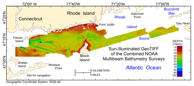
  3. What similar or related data should the user be aware of?
    Poppe, L.J., McMullen, K.Y., Ackerman, S.D., Blackwood, D.S., Irwin, B.J., Schaer, J.D., and Forrest, M.R., 2011, Sea-floor geology and character of Eastern Rhode Island Sound West of Gay Head, Massachusetts: Open-File Report 2011-1004, U.S. Geological Survey, Reston, VA.

    Online Links:

    Other_Citation_Details:
    1 DVD-ROM This publication provides a geological interpretation of NOAA survey H11922.
    Schattgen, P. Tod, 2009, H12009: Descriptive Report H12009, National Ocean Survey, National Oceanic and Atmospheric Administration, Atlantic Hydrographic Branch, Norfolk, VA.

    Online Links:

    Smith, Shepard M., 2009, H12010: Descriptive Report H12010, National Ocean Survey, National Oceanic and Atmospheric Administration, Atlantic Hydrographic Branch, Norfolk, VA.

    Online Links:

    Smith, Shepard M., 2009, H12011: Descriptive Report H12011, National Ocean Survey, National Oceanic and Atmospheric Administration, Atlantic Hydrographic Branch, Norfolk, VA.

    Online Links:

    Smith, Shepard M., 2009, H12015: Descriptive Report H12015, National Ocean Survey, National Oceanic and Atmospheric Administration, Atlantic Hydrographic Branch, Norfolk, VA.

    Online Links:

    Smith, Shepard M., 2009, H12033: Descriptive Report H12033, National Ocean Survey, National Oceanic and Atmospheric Administration, Atlantic Hydrographic Branch, Norfolk, VA.

    Online Links:

    Smith, Shepard M., 2009, H12137: Descriptive Report H12137, National Ocean Survey, National Oceanic and Atmospheric Administration, Atlantic Hydrographic Branch, Norfolk, VA.

    Online Links:

    Smith, Shepard M., 2009, H12139: Descriptive Report H12139, National Ocean Survey, National Oceanic and Atmospheric Administration, Atlantic Hydrographic Branch, Norfolk, VA.

    Online Links:

    McMullen, K.Y., Poppe, L.J., Ackerman, S.D., Blackwood, D.S., Schaer, J.D., Nadeau, M.A., and Wood, D.A., 2011, Surficial geology of the sea floor in central Rhode Island Sound southeast of Point Judith, Rhode Island: Open-File Report 2011-1005, U.S. Geological Survey, Reston, VA.

    Online Links:

    Other_Citation_Details:
    1 DVD-ROM This publication provides a geological interpretation of NOAA survey H11996.
    McMullen, K.Y., Poppe, L.J., Denny, J.F., Haupt, T.A., and Crocker, J.M., 2008, Sidescan-sonar imagery and surficial geologic interpretations of the sea floor in central Rhode Island Sound: Open-File Report 2007-1366, U.S. Geological Survey, Reston, VA.

    Online Links:

    Other_Citation_Details: 1 DVD-ROM
    McMullen, K.Y., Poppe, L.J., Haupt, T.A., and Crocker, J.M., 2009, Sidescan-sonar imagery and surficial geologic interpretations of the sea floor in western Rhode Island Sound: Open-File Report 2008-1181, U.S. Geological Survey, Reston, VA.

    Online Links:

    Other_Citation_Details: 1 DVD-ROM
    Schattgen, P.T., 2008, H11922: Descriptive Report H11922, National Ocean Survey, National Oceanic and Atmospheric Administration, Atlantic Hydrographic Branch, Norfolk, VA.

    Online Links:

    Schattgen, P.T., 2008, H11995: Descriptive Report H11995, National Ocean Survey, National Oceanic and Atmospheric Administration, Atlantic Hydrographic Branch, Norfolk, VA.

    Online Links:

    Schattgen, P.T., 2008, H11996: Descriptive Report H11996, National Ocean Survey, National Oceanic and Atmospheric Administration, Atlantic Hydrographic Branch, Norfolk, VA.

    Online Links:

    Smith, S.M., 2009, H12023: Descriptive Report Information unavailable from original metadata., National Ocean Survey, National Oceanic and Atmospheric Administration, Atlantic Hydrographic Branch, Norfolk, VA.

    Online Links:

    Krepp, L.T., 2011, H12296: Descriptive Report H12296, National Ocean Survey, National Oceanic and Atmospheric Administration, Atlantic Hydrographic Branch, Norfolk, VA.

    Online Links:

    Krepp, L.T., 2011, H12298: Descriptive Report H12298, National Ocean Survey, National Oceanic and Atmospheric Administration, Atlantic Hydrographic Branch, Norfolk, VA.

    Online Links:

    Krepp, L.T., 2011, H12299: Descriptive Report H12299, National Ocean Survey, National Oceanic and Atmospheric Administration, Atlantic Hydrographic Branch, Norfolk, VA.

    Online Links:

    McMullen, K.Y., Poppe, L.J., Ackerman, S.D., Worley, C.R., Nadeau, M.A., and Van Hoy, M.V., 2012, Sea-floor geology in central Rhode Island Sound south of Sakonnet Point, Rhode Island: Open-File Report 2012-1004, U.S. Geological Survey, Reston, VA.

    Online Links:

    Other_Citation_Details:
    1 DVD-ROM This publication provides a geological interpretation of NOAA survey H11995.
    Poppe, L.J., Danforth, W.W., McMullen, K.Y., Blankenship, M.A., Glomb, K.A., Wright, D.B., and Smith, S.M., 2012, Sea-floor character and sedimentary processes of Block Island Sound, Offshore Rhode Island:: Open-File Report 2012-1005, U.S. Geological Survey, Reston, VA.

    Online Links:

    Other_Citation_Details:
    1 DVD-ROM This publication provides geological interpretations of NOAA surveys H12009, H12010, H12011, H12015, H12033, H12137, and H12139.
    McMullen, K.Y., Poppe, L.J., Ackerman, S.D., Blackwood, D.S., Lewit, P.G., and Parker, C.E., 2013, Sea-floor geology in northeastern Block Island Sound, Rhode Island: Open-File Report 2013-1003, U.S. Geological Survey, Reston, VA.

    Online Links:

    Other_Citation_Details:
    1 DVD-ROM This publication provides a geological interpretation of NOAA survey H12023.
    McMullen, K.Y., Poppe, L.J., Ackerman, S.D., Blackwood, D.S., Glomb, K.A., and Wood, D.A., 2014, Sea-floor geology in northwestern Block Island Sound, Rhode Island: Open-File Report 2014-1018, U.S. Geological Survey, Reston, VA.

    Online Links:

    Other_Citation_Details: 1 DVD-ROM

How reliable are the data; what problems remain in the data set?

  1. How well have the observations been checked?
  2. How accurate are the geographic locations?
    Horizontal position of the launches acquiring multibeam bathymetry were determined using GPS corrected by U.S. Coast Guard differential GPS beacon stations at Moriches, NY and Acushnet, MA. The final CARIS combined base surfaces for the MBES data were originally produced at a 2-m cell size.
  3. How accurate are the heights or depths?
    Attitude of the launches (e.g. pitch, roll, and heave) acquiring multibeam bathymetry were monitored by an Applanix TSS POS/MV 320 Version 3 GPS aided navigation system. Verified water levels are based on National Water Level Observation Network (NWLON) stations 8461490, New London, CT; 8452660, Newport, RI; 8448725, Menemsha Harbor, MA; and 8510560, Montauk, NY. The vertical resolution of the multibeam data is approximately 0.5% of the water depth. Although there are no depth attributes associated with the GeoTIFF image, pixel values convey RGB values of individual cells. Warmer colors (e.g. red) are shallower depths; cooler colors are deeper.
  4. Where are the gaps in the data? What is missing?
    All collected data were processed and used to produce this dataset.
  5. How consistent are the relationships among the observations, including topology?
    No additional checks for consistency were performed on this data.

How can someone get a copy of the data set?

Are there legal restrictions on access or use of the data?
Access_Constraints: None
Use_Constraints:
Data are not to be used for navigation purposes. Public domain data are freely redistributable with proper metadata and source attribution. Please recognize the National Oceanic and Atmospheric Administration (NOAA) and U.S. Geological Survey (USGS) as the originators of this information.
  1. Who distributes the data set? (Distributor 1 of 1)
    U.S. Geological Survey
    Attn: Larry Poppe
    Geologist
    384 Woods Hole Road
    Woods Hole, MA
    USA

    (508) 548-8700 x2314 (voice)
    (508) 457-2310 (FAX)
    lpoppe@usgs.gov
  2. What's the catalog number I need to order this data set? Downloadable Data
  3. What legal disclaimers am I supposed to read?
    Neither the U.S. Government, the Department of the Interior, nor the USGS, nor the National Oceanic and Atmospheric Administration (NOAA), nor any of their employees, contractors, or subcontractors, make any warranty, express or implied, nor assume any legal liability or responsibility for the accuracy, completeness, or usefulness of any information, apparatus, product, or process disclosed, nor represent that its use would not infringe on privately owned rights. The act of distribution shall not constitute any such warranty, and no responsibility is assumed by the USGS or NOAA in the use of these data or related materials. Any use of trade, product, or firm names is for descriptive purposes only and does not imply endorsement by the U.S. Government.
  4. How can I download or order the data?
  5. What hardware or software do I need in order to use the data set?
    This image is available as a GeoTIFF image with an accompanying world file. To utilize this data, the user must have an image viewer, image processing or GIS software package capable of importing a GeoTIFF image. The user must have software capable of uncompressing archived zip files, such as WinZip or Pkware.

Who wrote the metadata?

Dates:
Last modified: 16-Nov-2021
Metadata author:
Larry Poppe
U.S. Geological Survey
Geologist
384 Woods Hole Road
Woods Hole, MA
USA

(508) 548-8700 x2314 (voice)
(508) 457-2310 (FAX)
whsc_data_contact@usgs.gov
Contact_Instructions:
The metadata contact email address is a generic address in the event the metadata contact is no longer with the USGS or the email is otherwise invalid.
Metadata standard:
FGDC Content Standards for Digital Geospatial Metadata (FGDC-STD-001-1998)

This page is <https://cmgds.marine.usgs.gov/catalog/whcmsc/open_file_report/ofr2014-1012/ricomb_4mmb_geo.faq.html>
Generated by mp version 2.9.50 on Tue Nov 16 10:06:51 2021