4-m Grid of the Combined Multibeam Bathymetry Generated from National Oceanic and Atmospheric Administration (NOAA) Surveys H11922, H11995, H11996, H12009, H12010, H12011, H12015, H12023, H12033, H12137, H12139, H12296, H12298, H12299 Offshore in Rhode island and Block Island Sound (RICOMB_4MUTM, UTM Zone 19, NAD 83)

Metadata also available as - [Questions & Answers] - [Parseable text] - [XML]

Metadata:

Identification_Information:
Citation:
Citation_Information:
Originator: National Oceanic and Atmospheric Administration
Originator: U.S. Geological Survey
Publication_Date: 2014
Title:
4-m Grid of the Combined Multibeam Bathymetry Generated from National Oceanic and Atmospheric Administration (NOAA) Surveys H11922, H11995, H11996, H12009, H12010, H12011, H12015, H12023, H12033, H12137, H12139, H12296, H12298, H12299 Offshore in Rhode island and Block Island Sound (RICOMB_4MUTM, UTM Zone 19, NAD 83)
Edition: 1.0
Geospatial_Data_Presentation_Form: raster digital data
Series_Information:
Series_Name: Open-File Report
Issue_Identification: 2014-1012
Publication_Information:
Publication_Place: Woods Hole Coastal and Marine Science Center, Woods Hole, MA
Publisher: U.S. Geological Survey, Coastal and Marine Geology Program
Online_Linkage: https://doi.org/10.3133/ofr20141012
Online_Linkage: Online_Linkage: http://pubs.usgs.gov/of/2014/1012/html/catalog.html
Larger_Work_Citation:
Citation_Information:
Originator: L.J. Poppe
Originator: K.Y. McMullen
Originator: W.W. Danforth
Originator: M.A. Blankenship
Originator: A.R. Clos
Originator: K.A. Glomb
Originator: P.G. Lewit
Originator: M.A. Nadeau
Originator: D.A. Wood
Originator: C.E. Parker
Publication_Date: 2014
Title:
Combined Multibeam Bathymetry Data from Rhode Island Sound and Block Island Sound - A Regional Perspective
Edition: 1.0
Series_Information:
Series_Name: Open-File Report
Issue_Identification: 2014-1012
Publication_Information:
Publication_Place: Reston, VA
Publisher: U.S. Geological Survey
Online_Linkage: http://pubs.usgs.gov/of/2014/1012/
Description:
Abstract:
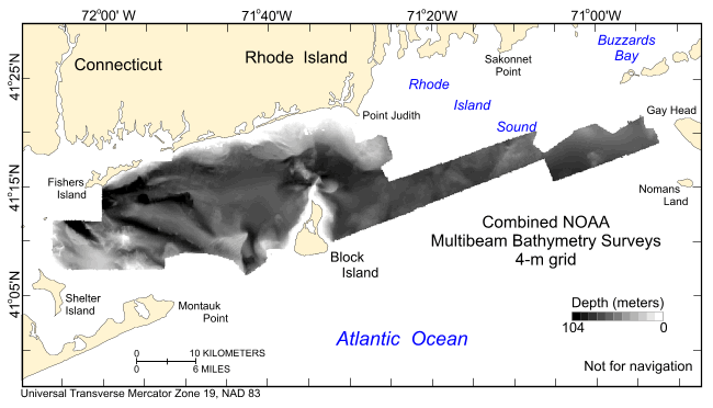
Detailed bathymetric maps of the sea floor in Block Island and Rhode Island Sounds are of great interest to the New York, Rhode Island, and Massachusetts research and management communities because of this area's ecological, recreational, and commercial importance. Geologically interpreted digital terrain models (DTMs) from individual surveys provide important benthic environmental information, yet many applications require a geographically broader perspective. For example, individual surveys are of limited use for the planning and construction of cross-sound infrastructure, such as cables and pipelines, or for the testing of regional circulation models. To address this need, we integrated 14 contiguous multibeam bathymetric DTMs, produced by the National Oceanic and Atmospheric Administration during charting operations, into one dataset that covers much of Block Island Sound and extends eastward across Rhode Island Sound. The new dataset, which covers over 1255 square kilometers, is adjusted to mean lower low water, is gridded to 4-meter resolution, and is provided in UTM Zone 19 NAD 83 and geographic WGS 84 projections. This resolution is adequate for sea-floor feature and process interpretation but is small enough to be queried and manipulated with standard Geographic Information System programs and to allow for future growth. Natural features visible in the grid include boulder lag deposits of winnowed Pleistocene strata, sand-wave fields, and scour depressions that reflect the strength of the oscillating and asymmetric tidal currents and scour by storm-induced waves. Bedform asymmetry allows interpretations of net sediment transport. Together the merged data reveal a larger, more continuous perspective of bathymetric topography than previously available, providing a fundamental framework for research and resource management activities off the Rhode Island coast.
Purpose:
To release a 4-m grid of the combined multibeam bathymetry generated from NOAA surveys H11922, H11995, H11996, H12009, H12010, H12011, H12015, H12023, H12033, H12137, H12139, H12296, H12298, and H12299 offshore in Rhode Island and Block Island Sounds in UTM Zone 19, NAD 83.
Time_Period_of_Content:
Time_Period_Information:
Range_of_Dates/Times:
Beginning_Date: 20080716
Ending_Date: 20111116
Currentness_Reference:
ground condition (See the source citation in the lineage section for individual component's specific dates.)
Status:
Progress: Complete
Maintenance_and_Update_Frequency: None planned
Spatial_Domain:
Bounding_Coordinates:
West_Bounding_Coordinate: -72.126425
East_Bounding_Coordinate: -70.839693
North_Bounding_Coordinate: 41.403608
South_Bounding_Coordinate: 41.096725
Keywords:
Theme:
Theme_Keyword_Thesaurus: USGS Metadata Identifier
Theme_Keyword: USGS:de35f884-8d56-425b-badb-402718a8b5cd
Theme:
Theme_Keyword_Thesaurus: None
Theme_Keyword: U.S. Geological Survey
Theme_Keyword: USGS
Theme_Keyword: Woods Hole Coastal and Marine Science Center
Theme_Keyword: multibeam bathymetry
Theme_Keyword: Coastal and Marine Geology Program
Theme_Keyword: CMGP
Theme_Keyword: WHCMSC
Theme_Keyword: National Oceanic and Atmospheric Administration
Theme_Keyword: NOAA
Theme_Keyword: grid
Theme_Keyword: Open-File Report 2014-1012
Theme_Keyword: ArcRaster grid
Theme_Keyword: OFR 2014-1012
Theme_Keyword: RESON 8125
Theme_Keyword: bathymetry
Theme_Keyword: NOAA survey H12009
Theme_Keyword: NOAA survey H12010
Theme_Keyword: NOAA survey H12011
Theme_Keyword: NOAA survey H12015
Theme_Keyword: NOAA survey H12033
Theme_Keyword: NOAA survey H12137
Theme_Keyword: NOAA survey H12139
Theme_Keyword: H12009
Theme_Keyword: H12010
Theme_Keyword: H12011
Theme_Keyword: H12015
Theme_Keyword: H12033
Theme_Keyword: H12137
Theme_Keyword: H12139
Theme_Keyword: MBES
Theme_Keyword: RESON 7125
Theme_Keyword: Multibeal echosounder
Theme_Keyword: DTM
Theme_Keyword: digital terrain model
Theme_Keyword: NOAA survey H11922
Theme_Keyword: NOAA survey H11995
Theme_Keyword: NOAA survey H11996
Theme_Keyword: NOAA survey H12023
Theme_Keyword: NOAA survey H12296
Theme_Keyword: NOAA survey H12298
Theme_Keyword: NOAA survey H12299
Theme_Keyword: H11922
Theme_Keyword: H11995
Theme_Keyword: H11996
Theme_Keyword: H12023
Theme_Keyword: H12296
Theme_Keyword: H12298
Theme_Keyword: H12299
Theme:
Theme_Keyword_Thesaurus: ISO 19115 Topic Category
Theme_Keyword: elevation
Theme_Keyword: oceans
Theme:
Theme_Keyword_Thesaurus: USGS Thesaurus
Theme_Keyword: bathymetry
Theme_Keyword: sea-floor characteristics
Theme_Keyword: multibeam sonar
Theme_Keyword: marine geophysics
Theme_Keyword: geospatial datasets
Place:
Place_Keyword_Thesaurus: None
Place_Keyword: Rhode Island
Place_Keyword: Block Island
Place_Keyword: U.S. East Coast
Place_Keyword: United States
Place_Keyword: North America
Place_Keyword: Atlantic Ocean
Place_Keyword: Block Island Sound
Place_Keyword: Rhode Island Sound
Access_Constraints: None
Use_Constraints:
Data are not to be used for navigation purposes. Public domain data are freely redistributable with proper metadata and source attribution. Please recognize the National Oceanic and Atmospheric Administration (NOAA) and U.S. Geological Survey (USGS) as the originators of this information.
Point_of_Contact:
Contact_Information:
Contact_Organization_Primary:
Contact_Organization: U.S. Geological Survey
Contact_Person: Larry Poppe
Contact_Position: Geologist
Contact_Address:
Address_Type: mailing and physical address
Address: 384 Woods Hole Road
City: Woods Hole
State_or_Province: MA
Postal_Code: 02543-1598
Country: USA
Contact_Voice_Telephone: (508) 548-8700 x2314
Contact_Facsimile_Telephone: (508) 457-2310
Contact_Electronic_Mail_Address: lpoppe@usgs.gov
Browse_Graphic:
Browse_Graphic_File_Name: Browse_Graphic_File_Description:
Thumbnail image showing the combined 4-m gridded multibeam bathymetry collected during NOAA surveys H12009, H12010, H12011, H12015, H12023, H12033, H12137, H12139, H12296, H12298, and H12299 offshore in Rhode Island and Block Island Sounds in UTM Zone 19, NAD83
Browse_Graphic_File_Type: GIF
Native_Data_Set_Environment:
Microsoft Windows Vista Version 6.1 (Build 7601) Service Pack 1; ESRI ArcCatalog 9.3.1.1850
Cross_Reference:
Citation_Information:
Originator: P. Tod Schattgen
Publication_Date: 2009
Title: H12009
Edition: 1.0
Geospatial_Data_Presentation_Form: document
Series_Information:
Series_Name: Descriptive Report
Issue_Identification: H12009
Publication_Information:
Publication_Place: Atlantic Hydrographic Branch, Norfolk, VA
Publisher:
National Ocean Survey, National Oceanic and Atmospheric Administration
Online_Linkage:
Cross_Reference:
Citation_Information:
Originator: Shepard M. Smith
Publication_Date: 2009
Title: H12010
Edition: 1.0
Geospatial_Data_Presentation_Form: document
Series_Information:
Series_Name: Descriptive Report
Issue_Identification: H12010
Publication_Information:
Publication_Place: Atlantic Hydrographic Branch, Norfolk, VA
Publisher:
National Ocean Survey, National Oceanic and Atmospheric Administration
Online_Linkage:
Cross_Reference:
Citation_Information:
Originator: Shepard M. Smith
Publication_Date: 2009
Title: H12011
Edition: 1.0
Geospatial_Data_Presentation_Form: document
Series_Information:
Series_Name: Descriptive Report
Issue_Identification: H12011
Publication_Information:
Publication_Place: Atlantic Hydrographic Branch, Norfolk, VA
Publisher:
National Ocean Survey, National Oceanic and Atmospheric Administration
Online_Linkage:
Cross_Reference:
Citation_Information:
Originator: Shepard M. Smith
Publication_Date: 2009
Title: H12015
Edition: 1.0
Geospatial_Data_Presentation_Form: document
Series_Information:
Series_Name: Descriptive Report
Issue_Identification: H12015
Publication_Information:
Publication_Place: Atlantic Hydrographic Branch, Norfolk, VA
Publisher:
National Ocean Survey, National Oceanic and Atmospheric Administration
Online_Linkage:
Cross_Reference:
Citation_Information:
Originator: Shepard M. Smith
Publication_Date: 2009
Title: H12033
Edition: 1.0
Geospatial_Data_Presentation_Form: document
Series_Information:
Series_Name: Descriptive Report
Issue_Identification: H12033
Publication_Information:
Publication_Place: Atlantic Hydrographic Branch, Norfolk, VA
Publisher:
National Ocean Survey, National Oceanic and Atmospheric Administration
Online_Linkage:
Cross_Reference:
Citation_Information:
Originator: Shepard M. Smith
Publication_Date: 2009
Title: H12137
Edition: 1.0
Geospatial_Data_Presentation_Form: document
Series_Information:
Series_Name: Descriptive Report
Issue_Identification: H12137
Publication_Information:
Publication_Place: Atlantic Hydrographic Branch, Norfolk, VA
Publisher:
National Ocean Survey, National Oceanic and Atmospheric Administration
Online_Linkage:
Cross_Reference:
Citation_Information:
Originator: Shepard M. Smith
Publication_Date: 2009
Title: H12139
Edition: 1.0
Geospatial_Data_Presentation_Form: document
Series_Information:
Series_Name: Descriptive Report
Issue_Identification: H12139
Publication_Information:
Publication_Place: Atlantic Hydrographic Branch, Norfolk, VA
Publisher:
National Ocean Survey, National Oceanic and Atmospheric Administration
Online_Linkage:
Cross_Reference:
Citation_Information:
Originator: Poppe, L.J.
Originator: McMullen, K.Y.
Originator: Ackerman, S.D.
Originator: Blackwood, D.S.
Originator: Irwin, B.J.
Originator: Schaer, J.D.
Originator: Forrest, M.R.
Publication_Date: 2011
Title:
Sea-floor geology and character of eastern Rhode Island Sound west of Gay Head, Massachusetts
Edition: 1.0
Geospatial_Data_Presentation_Form: GIS data report
Series_Information:
Series_Name: Open-File Report
Issue_Identification: 2011-1004
Publication_Information:
Publication_Place: Reston, VA
Publisher: U.S. Geological Survey
Other_Citation_Details:
1 DVD-ROM This publication provides a geological interpretation of NOAA survey H11922.
Online_Linkage: http://pubs.usgs.gov/of/2011/1004/
Cross_Reference:
Citation_Information:
Originator: McMullen, K.Y.
Originator: Poppe, L.J.
Originator: Ackerman, S.D.
Originator: Blackwood, D.S.
Originator: Schaer, J.D.
Originator: Nadeau, M.A.
Originator: Wood, D.A.
Publication_Date: 2011
Title:
Surficial geology of the sea floor in central Rhode Island Sound southeast of Point Judith, Rhode Island
Edition: 1.0
Geospatial_Data_Presentation_Form: GIS data report
Series_Information:
Series_Name: Open-File Report
Issue_Identification: 2011-1005
Publication_Information:
Publication_Place: Reston, VA
Publisher: U.S. Geological Survey
Other_Citation_Details:
1 DVD-ROM This publication provides a geological interpretation of NOAA survey H11996
Online_Linkage: http://pubs.usgs.gov/of/2011/1005/
Cross_Reference:
Citation_Information:
Originator: McMullen, K.Y.
Originator: Poppe, L.J.
Originator: Denny, J.F.
Originator: Haupt, T.A.
Originator: Crocker, J.M.
Publication_Date: 2008
Title:
Sidescan-sonar imagery and surficial geologic interpretations of the sea floor in central Rhode Island Sound
Edition: 1.0
Geospatial_Data_Presentation_Form: GIS data report
Series_Information:
Series_Name: Open-File Report
Issue_Identification: 2007-1366
Publication_Information:
Publication_Place: Reston, VA
Publisher: U.S. Geological Survey
Other_Citation_Details: 1 DVD-ROM
Online_Linkage: http://pubs.usgs.gov/of/2007/1366/
Cross_Reference:
Citation_Information:
Originator: McMullen, K.Y.
Originator: Poppe, L.J.
Originator: Haupt, T.A.
Originator: Crocker, J.M.
Publication_Date: 2009
Title:
Sidescan-sonar imagery and surficial geologic interpretations of the sea floor in western Rhode Island Sound
Edition: 1.0
Geospatial_Data_Presentation_Form: GIS data report
Series_Information:
Series_Name: Open-File Report
Issue_Identification: 2008-1181
Publication_Information:
Publication_Place: Reston, VA
Publisher: U.S. Geological Survey
Other_Citation_Details: 1 DVD-ROM
Online_Linkage: http://pubs.usgs.gov/of/2008/1181/
Cross_Reference:
Citation_Information:
Originator: McMullen, K.Y.
Originator: Poppe, L.J.
Originator: Ackerman, S.D.
Originator: Worley, C.R.
Originator: Nadeau, M.A.
Originator: Van Hoy, M.V.
Publication_Date: 2012
Title:
Sea-floor geology in central Rhode Island Sound south of Sakonnet Point, Rhode Island
Edition: 1.0
Geospatial_Data_Presentation_Form: GIS data report
Series_Information:
Series_Name: Open-File Report
Issue_Identification: 2012-1004
Publication_Information:
Publication_Place: Reston, VA
Publisher: U.S. Geological Survey
Other_Citation_Details:
1 DVD-ROM This publication provides a geological interpretation of NOAA survey H11995.
Online_Linkage: http://pubs.usgs.gov/of/2012/1004/
Cross_Reference:
Citation_Information:
Originator: P.T. Schattgen
Publication_Date: 2008
Title: H11922
Edition: 1.0
Geospatial_Data_Presentation_Form: document
Series_Information:
Series_Name: Descriptive Report
Issue_Identification: H11922
Publication_Information:
Publication_Place: Atlantic Hydrographic Branch, Norfolk, VA
Publisher:
National Ocean Survey, National Oceanic and Atmospheric Administration
Online_Linkage:
Cross_Reference:
Citation_Information:
Originator: P.T. Schattgen
Publication_Date: 2008
Title: H11995
Edition: 1.0
Geospatial_Data_Presentation_Form: document
Series_Information:
Series_Name: Descriptive Report
Issue_Identification: H11995
Publication_Information:
Publication_Place: Atlantic Hydrographic Branch, Norfolk, VA
Publisher:
National Ocean Survey, National Oceanic and Atmospheric Administration
Online_Linkage:
Cross_Reference:
Citation_Information:
Originator: P.T. Schattgen
Publication_Date: 2008
Title: H11996
Edition: 1.0
Geospatial_Data_Presentation_Form: document
Series_Information:
Series_Name: Descriptive Report
Issue_Identification: H11996
Publication_Information:
Publication_Place: Atlantic Hydrographic Branch, Norfolk, VA
Publisher:
National Ocean Survey, National Oceanic and Atmospheric Administration
Online_Linkage:
Cross_Reference:
Citation_Information:
Originator: S.M. Smith
Publication_Date: 2009
Title: H12023
Edition: 1.0
Geospatial_Data_Presentation_Form: diagram
Series_Information:
Series_Name: Descriptive Report
Issue_Identification: H12023
Publication_Information:
Publication_Place: Atlantic Hydrographic Branch, Norfolk, VA
Publisher:
National Ocean Survey, National Oceanic and Atmospheric Administration
Online_Linkage:
Cross_Reference:
Citation_Information:
Originator: L.T. Krepp
Publication_Date: 2011
Title: H12296
Edition: 1.0
Geospatial_Data_Presentation_Form: document
Series_Information:
Series_Name: Descriptive Report
Issue_Identification: H12296
Publication_Information:
Publication_Place: Atlantic Hydrographic Branch, Norfolk, VA
Publisher:
National Ocean Survey, National Oceanic and Atmospheric Administration
Online_Linkage:
Cross_Reference:
Citation_Information:
Originator: L.T. Krepp
Publication_Date: 2011
Title: H12298
Edition: 1.0
Geospatial_Data_Presentation_Form: document
Series_Information:
Series_Name: Descriptive Report
Issue_Identification: H12298
Publication_Information:
Publication_Place: Atlantic Hydrographic Branch, Norfolk, VA
Publisher:
National Ocean Survey, National Oceanic and Atmospheric Administration
Online_Linkage:
Cross_Reference:
Citation_Information:
Originator: L.T. Krepp
Publication_Date: 2011
Title: H12299
Edition: 1.0
Geospatial_Data_Presentation_Form: document
Series_Information:
Series_Name: Descriptive report
Issue_Identification: H12299
Publication_Information:
Publication_Place: Atlantic Hydrographic Branch, Norfolk, VA
Publisher:
National Ocean Survey, National Oceanic and Atmospheric Administration
Online_Linkage:
Cross_Reference:
Citation_Information:
Originator: Poppe, L.J.
Originator: Danforth, W.W.
Originator: McMullen, K.Y.
Originator: Blankenship, M.A.
Originator: Glomb, K.A.
Originator: Wright, D.B.
Originator: Smith, S.M.
Publication_Date: 2012
Title:
Sea-floor character and sedimentary processes of Block Island Sound, Offshore Rhode Island
Edition: 1.0
Geospatial_Data_Presentation_Form: GIS data report
Series_Information:
Series_Name: Open-File Report
Issue_Identification: 2012-1005
Publication_Information:
Publication_Place: Reston, VA
Publisher: U.S. Geological Survey
Other_Citation_Details:
1 DVD-ROM This publication provides geological interpretations of NOAA surveys H12009, H12010, H12011, H12015, H12033, H12137, and H12139.
Online_Linkage: http://pubs.usgs.gov/of/2012/1005/
Cross_Reference:
Citation_Information:
Originator: McMullen, K.Y.
Originator: Poppe, L.J.
Originator: Ackerman, S.D.
Originator: Blackwood, D.S.
Originator: Lewit, P.G.
Originator: Parker, C.E.
Publication_Date: 2013
Title:
Sea-floor geology in northeastern Block Island Sound, Rhode Island
Edition: 1.0
Geospatial_Data_Presentation_Form: GIS data report
Series_Information:
Series_Name: Open-File Report
Issue_Identification: 2013-1003
Publication_Information:
Publication_Place: Reston, VA
Publisher: U.S. Geological Survey
Other_Citation_Details:
1 DVD-ROM This publication provides a geological interpretation of NOAA survey H12023.
Online_Linkage: http://pubs.usgs.gov/of/2013/1003/
Cross_Reference:
Citation_Information:
Originator: McMullen, K.Y.
Originator: Poppe, L.J.
Originator: Ackerman, S.D.
Originator: Blackwood, D.S.
Originator: Glomb, K.A.
Originator: Wood, D.A.
Publication_Date: 2014
Title:
Sea-floor geology in northwestern Block Island Sound, Rhode Island
Edition: 1.0
Geospatial_Data_Presentation_Form: GIS data report
Series_Information:
Series_Name: Open-File Report
Issue_Identification: 2014-1018
Publication_Information:
Publication_Place: Reston, VA
Publisher: U.S. Geological Survey
Other_Citation_Details:
1 DVD-ROM This publication provides a geological interpretation of NOAA survey H12296.
Online_Linkage: http://pubs.usgs.gov/of/2014/1018/
Data_Quality_Information:
Logical_Consistency_Report:
No additional checks for consistency were performed on this data.
Completeness_Report:
All collected data were processed and used to produce this dataset.
Positional_Accuracy:
Horizontal_Positional_Accuracy:
Horizontal_Positional_Accuracy_Report:
Horizontal position of the launches acquiring multibeam bathymetry were determined using GPS corrected by U.S. Coast Guard differential GPS beacon stations at Moriches, NY and Acushnet, MA. The final CARIS combined base surfaces for the MBES data were produced at a 2-m cell size.
Vertical_Positional_Accuracy:
Vertical_Positional_Accuracy_Report:
Attitude of the launches (e.g. pitch, roll, and heave) acquiring multibeam bathymetry were monitored by an Applanix TSS POS/MV 320 Version 3 GPS aided navigation system. Verified water levels are based on National Water Level Observation Network (NWLON) stations 8461490, New London, CT; 8452660, Newport, RI; 8510560, Montauk, NY; and 8448725, Menemsha Harbor, MA. The vertical resolution of the multibeam data is approximately 0.5% of the water depth.
Lineage:
Source_Information:
Source_Citation:
Citation_Information:
Originator: P. Tod Schattgen
Originator:
Atlantic Hydrographic Branch, National Ocean Survey, National Oceanic and Atmospheric Administration, Norfolk, VA
Publication_Date: Unpublished Material
Title: H12009 bathymetry
Geospatial_Data_Presentation_Form: CARIS HIPS dataset
Type_of_Source_Media: computer hard drive
Source_Time_Period_of_Content:
Time_Period_Information:
Range_of_Dates/Times:
Beginning_Date: 20090508
Ending_Date: 20090519
Source_Currentness_Reference: ground condition
Source_Citation_Abbreviation: H12009 CARIS HIPS database
Source_Contribution: Original processed multibeam bathymetric data.
Source_Information:
Source_Citation:
Citation_Information:
Originator: Shepard M. Smith
Originator:
Atlantic Hydrographic Branch, National Ocean Survey, National Oceanic and Atmospheric Administration, Norfolk, VA
Publication_Date: Unpublished Material
Title: H12010 bathymetry
Geospatial_Data_Presentation_Form: CARIS HIPS dataset
Type_of_Source_Media: computer hard drive
Source_Time_Period_of_Content:
Time_Period_Information:
Range_of_Dates/Times:
Beginning_Date: 20090723
Ending_Date: 20090819
Source_Currentness_Reference: ground condition
Source_Citation_Abbreviation: H12010 CARIS HIPS database
Source_Contribution: Original processed multibeam bathymetric data.
Source_Information:
Source_Citation:
Citation_Information:
Originator: Shepard M. Smith
Originator:
Atlantic Hydrographic Branch, National Ocean Survey, National Oceanic and Atmospheric Administration, Norfolk, VA
Publication_Date: Unpublished Material
Title: H12011 bathymetry
Geospatial_Data_Presentation_Form: CARIS HIPS dataset
Type_of_Source_Media: computer hard drive
Source_Time_Period_of_Content:
Time_Period_Information:
Range_of_Dates/Times:
Beginning_Date: 20090724
Ending_Date: 20090825
Source_Currentness_Reference: ground condition
Source_Citation_Abbreviation: H12011 CARIS HIPS database
Source_Contribution: Original processed multibeam bathymetric data.
Source_Information:
Source_Citation:
Citation_Information:
Originator: Shepard M. Smith
Originator:
Atlantic Hydrographic Branch, National Ocean Survey, National Oceanic and Atmospheric Administration, Norfolk, VA
Publication_Date: Unpublished Material
Title: H12015 bathymetry
Geospatial_Data_Presentation_Form: CARIS HIPS dataset
Type_of_Source_Media: computer hard drive
Source_Time_Period_of_Content:
Time_Period_Information:
Range_of_Dates/Times:
Beginning_Date: 20090927
Ending_Date: 20091014
Source_Currentness_Reference: ground condition
Source_Citation_Abbreviation: H12015 CARIS HIPS database
Source_Contribution: Original processed multibeam bathymetric data.
Source_Information:
Source_Citation:
Citation_Information:
Originator: Shepard M. Smith
Originator:
Atlantic Hydrographic Branch, National Ocean Survey, National Oceanic and Atmospheric Administration, Norfolk, VA
Publication_Date: Unpublished Material
Title: H12033 bathymetry
Geospatial_Data_Presentation_Form: CARIS HIPS dataset
Type_of_Source_Media: computer hard drive
Source_Time_Period_of_Content:
Time_Period_Information:
Range_of_Dates/Times:
Beginning_Date: 20090807
Ending_Date: 20090821
Source_Currentness_Reference: ground condition
Source_Citation_Abbreviation: H12033 CARIS HIPS database
Source_Contribution: Original processed multibeam bathymetric data.
Source_Information:
Source_Citation:
Citation_Information:
Originator: Shepard M. Smith
Originator:
Atlantic Hydrographic Branch, National Ocean Survey, National Oceanic and Atmospheric Administration, Norfolk, VA
Publication_Date: Unpublished Material
Title: H12137 bathymetry
Geospatial_Data_Presentation_Form: raster digital data
Type_of_Source_Media: computer hard drive
Source_Time_Period_of_Content:
Time_Period_Information:
Range_of_Dates/Times:
Beginning_Date: 20090809
Ending_Date: 20090821
Source_Currentness_Reference: ground condition
Source_Citation_Abbreviation: H12137 CARIS HIPS database
Source_Contribution: Original processed multibeam bathymetric data.
Source_Information:
Source_Citation:
Citation_Information:
Originator: Shepard M. Smith
Originator:
Atlantic Hydrographic Branch, National Ocean Survey, National Oceanic and Atmospheric Administration, Norfolk, VA
Publication_Date: Unpublished Material
Title: H12139 bathymetry
Geospatial_Data_Presentation_Form: raster digital data
Type_of_Source_Media: computer hard drive
Source_Time_Period_of_Content:
Time_Period_Information:
Range_of_Dates/Times:
Beginning_Date: 20090820
Ending_Date: 20090831
Source_Currentness_Reference: ground condition
Source_Citation_Abbreviation: H12139 CARIS HIPS database
Source_Contribution: Original processed multibeam bathymetric data.
Source_Information:
Source_Citation:
Citation_Information:
Originator: P. Tod Schattgen
Originator:
Atlantic Hydrographic Branch, National Ocean Survey, National Oceanic and Atmospheric Administration, Norfolk, VA
Publication_Date: Unpublished Material
Title: H11922 bathymetry
Type_of_Source_Media: computer hard drive
Source_Time_Period_of_Content:
Time_Period_Information:
Range_of_Dates/Times:
Beginning_Date: 20080716
Ending_Date: 20080822
Source_Currentness_Reference: ground condition
Source_Citation_Abbreviation: H11922 CARIS HIPS database
Source_Contribution: Original processed multibeam bathymetric data.
Source_Information:
Source_Citation:
Citation_Information:
Originator: P. Tod Schattgen
Originator:
Atlantic Hydrographic Branch, National Ocean Survey, National Oceanic and Atmospheric Administration, Norfolk, VA
Publication_Date: Unpublished Material
Title: H11995 bathymetry
Type_of_Source_Media: computer hard drive
Source_Time_Period_of_Content:
Time_Period_Information:
Range_of_Dates/Times:
Beginning_Date: 200821
Ending_Date: 20080930
Source_Currentness_Reference: ground condition
Source_Citation_Abbreviation: H11995 CARIS HIPS database
Source_Contribution: Original processed multibeam bathymetric data.
Source_Information:
Source_Citation:
Citation_Information:
Originator: P. Tod Schattgen
Originator:
Atlantic Hydrographic Branch, National Ocean Survey, National Oceanic and Atmospheric Administration, Norfolk, VA
Publication_Date: Unpublished Material
Title: H11996 bathymetry
Geospatial_Data_Presentation_Form: CARIS HIPS dataset
Type_of_Source_Media: computer hard drive
Source_Time_Period_of_Content:
Time_Period_Information:
Range_of_Dates/Times:
Beginning_Date: 20080907
Ending_Date: 20081001
Source_Currentness_Reference: ground condition
Source_Citation_Abbreviation: H11996 CARIS HIPS database
Source_Contribution: Original processed multibeam bathymetric data.
Source_Information:
Source_Citation:
Citation_Information:
Originator: S.M. Smith
Originator:
Atlantic Hydrographic Branch, National Ocean Survey, National Oceanic and Atmospheric Administration, Norfolk, VA
Publication_Date: Unpublished Material
Title: H12023 bathymetry
Geospatial_Data_Presentation_Form: CARIS HIPS dataset
Type_of_Source_Media: computer hard drive
Source_Time_Period_of_Content:
Time_Period_Information:
Range_of_Dates/Times:
Beginning_Date: 20090824
Ending_Date: 20091014
Source_Currentness_Reference: ground condition
Source_Citation_Abbreviation: H12023 CARIS HIPS database
Source_Contribution: Original processed multibeam bathymetric data.
Source_Information:
Source_Citation:
Citation_Information:
Originator: L.T. Krepp
Originator:
Atlantic Hydrographic Branch, National Ocean Survey, National Oceanic and Atmospheric Administration, Norfolk, VA
Publication_Date: Unpublished Material
Title: H12296 bathymetry
Geospatial_Data_Presentation_Form: CARIS HIPS dataset
Type_of_Source_Media: computer hard drive
Source_Time_Period_of_Content:
Time_Period_Information:
Range_of_Dates/Times:
Beginning_Date: 20110822
Ending_Date: 20111023
Source_Currentness_Reference: ground condition
Source_Citation_Abbreviation: H12296 CARIS HIPS database
Source_Contribution: Original processed multibeam bathymetric data.
Source_Information:
Source_Citation:
Citation_Information:
Originator: L.T. Krepp
Originator:
Atlantic Hydrographic Branch, National Ocean Survey, National Oceanic and Atmospheric Administration, Norfolk, VA
Publication_Date: Unpublished Material
Title: H12298
Geospatial_Data_Presentation_Form: CARIS HIPS dataset
Type_of_Source_Media: computer hard drive
Source_Time_Period_of_Content:
Time_Period_Information:
Range_of_Dates/Times:
Beginning_Date: 20110831
Ending_Date: 20111116
Source_Currentness_Reference: ground condition
Source_Citation_Abbreviation: H12298 CARIS HIPS database
Source_Contribution: Original processed multibeam bathymetric data.
Source_Information:
Source_Citation:
Citation_Information:
Originator: L.T. Krepp
Originator:
Atlantic Hydrographic Branch, National Ocean Survey, National Oceanic and Atmospheric Administration, Norfolk, VA
Publication_Date: Unpublished Material
Title: H12299 bathymetry
Geospatial_Data_Presentation_Form: CARIS HIPS dataset
Type_of_Source_Media: computer hard drive
Source_Time_Period_of_Content:
Time_Period_Information:
Range_of_Dates/Times:
Beginning_Date: 20110912
Ending_Date: 20111115
Source_Currentness_Reference: ground condition
Source_Citation_Abbreviation: H12299 CARIS HIPS database
Source_Contribution: Original processed multibeam bathymetric data.
Process_Step:
Process_Description:
The 63-m NOAA Ship Thomas Jefferson and two 8.5-m aluminum Jensen launches (3101 and 3102) deployed from the ship acquired multibeam echosounder (MBES) data for 14 hydrographic surveys in Rhode Island and Block Island Sounds over an approximately 1255.6-square kilometer area between July 2008 and November 2011. Registry numbers for the completed surveys include: H11922, H11995, H11996, H12009, H12010, H12011, H12015, H12023, H12033, H12137, H12139, H12296, H12298, and H12299. During 2008, the MBES data were collected with a hull-mounted RESON SeaBat 240-kHz 8101 and 455-kHz 8125 shallow-water system aboard the launches and a RESON duel frequency (200-kHz/400-kHz) 7125 system aboard the NOAA Ship Thomas Jefferson. During 2009 and 2011, the MBES data were collected with a hull-mounted RESON SeaBat 455-kHz 8125 shallow-water system aboard launch 3101 and RESON single frequency (400-kHz) 7125 systems aboard launch 3102 and the NOAA Ship Thomas Jefferson. The vertical resolution of the multibeam data is approximately 0.5% of the water depth. The bathymetric datasets were acquired and digitally logged with HYPACK Hysweep, and processed by NOAA using CARIS Hydrographic Image Processing System (HIPS) software for quality control, to incorporate sound velocity and tidal corrections, and to produce the combined bathymetry adjusted for statistical error (BASE) surfaces. Horizontal positioning was by differential global positioning systems (DGPS); HYPACK was used for acquisition line navigation. Sound-velocity corrections were derived with frequent conductivity-temperature-depth profiles. A Brooke Ocean Technology Moving Vessel Profiler (MVP) with an Applied Microsystems Smart Sound Velocity and Pressure (SV&P) sensor was used to collect sound speed profile data from the ship. Manually deployed Seabird Electronics SBE-19+ CTD units were used to collect sound speed profile data from the launches. Tidal zone corrections were calculated from data acquired by the National Water Level Observation Network stations at New London, Connecticut (8461490); Newport, Rhode Island (8452660); Menemsha Harbor, Massachusetts (8448725); and Montauk, New York (8510560). The vertical datum is mean lower low water; X and Y units are meters, UTM Zone 19, NAD 83. Detailed descriptions of the MBES acquisition and processing by NOAA can be found in the Descriptive Reports and in the Data Acquisition and Processing Reports.
Process_Date: Unknown
Source_Produced_Citation_Abbreviation: H12009 CARIS HIPS database
Source_Produced_Citation_Abbreviation: H12010 CARIS HIPS database
Source_Produced_Citation_Abbreviation: H12011 CARIS HIPS database
Source_Produced_Citation_Abbreviation: H12015 CARIS HIPS database
Source_Produced_Citation_Abbreviation: H12033 CARIS HIPS database
Source_Produced_Citation_Abbreviation: H12137 CARIS HIPS database
Source_Produced_Citation_Abbreviation: H12139 CARIS HIPS database
Source_Produced_Citation_Abbreviation: H11922 CARIS HIPS database
Source_Produced_Citation_Abbreviation: H11995 CARIS HIPS database
Source_Produced_Citation_Abbreviation: H11996 CARIS HIPS database
Source_Produced_Citation_Abbreviation: H12023 CARIS HIPS database
Source_Produced_Citation_Abbreviation: H12296 CARIS HIPS database
Source_Produced_Citation_Abbreviation: H12298 CARIS HIPS database
Source_Produced_Citation_Abbreviation: H12299 CARIS HIPS database
Process_Contact:
Contact_Information:
Contact_Organization_Primary:
Contact_Organization: National Oceanic and Atmospheric Administration
Contact_Person: Castle Eugene Parker
Contact_Position: Hydrographer
Contact_Address:
Address_Type: mailing address
Address: 439 West York Street
City: Norfolk
State_or_Province: VA
Postal_Code: 23510
Country: USA
Contact_Voice_Telephone: 757-441-6746
Contact_Electronic_Mail_Address: castle.e.parker@noaa.gov
Process_Step:
Process_Description:
The field sheets from the surveys (average depths, not the shoal based field sheets) were read back into CARIS HIPS/SIPS software version 7.1. Using the Base Surface -> Combine command within HIPS, all of the source CARIS base surfaces were combined into a master BASE surface (ricomb_4m) having a 4 meter grid resolution.
Source_Used_Citation_Abbreviation: H12009 CARIS HIPS database
Source_Used_Citation_Abbreviation: H12010 CARIS HIPS database
Source_Used_Citation_Abbreviation: H12011 CARIS HIPS database
Source_Used_Citation_Abbreviation: H12015 CARIS HIPS database
Source_Used_Citation_Abbreviation: H12033 CARIS HIPS database
Source_Used_Citation_Abbreviation: H12137 CARIS HIPS database
Source_Used_Citation_Abbreviation: H12139 CARIS HIPS database
Source_Used_Citation_Abbreviation: H11922 CARIS HIPS database
Source_Used_Citation_Abbreviation: H11995 CARIS HIPS database
Source_Used_Citation_Abbreviation: H11996 CARIS HIPS database
Source_Used_Citation_Abbreviation: H12023 CARIS HIPS database
Source_Used_Citation_Abbreviation: H12296 CARIS HIPS database
Source_Used_Citation_Abbreviation: H12298 CARIS HIPS database
Source_Used_Citation_Abbreviation: H12299 CARIS HIPS database
Process_Date: 2013
Source_Produced_Citation_Abbreviation: ricomb_4m
Process_Contact:
Contact_Information:
Contact_Person_Primary:
Contact_Person: Bill Danforth
Contact_Organization: U.S. Geological Survey
Contact_Position: Geologist
Contact_Address:
Address_Type: mailing and physical address
Address: 384 Woods Hole Road
City: Woods Hole
State_or_Province: MA
Postal_Code: 02543-1598
Contact_Voice_Telephone: 508-548-8700 x2274
Contact_Facsimile_Telephone: 508-457-2310
Contact_Electronic_Mail_Address: bdanforth@usgs.gov
Process_Step:
Process_Description:
The combined base surface was exported from CARIS as a Bathymetric Attributed Grid (BAG) file. See http://www.opennavsurf.org/papers/ons_fsd.pdf for a description of the BAG format.
Source_Used_Citation_Abbreviation: ricomb_4m
Process_Date: 2013
Source_Produced_Citation_Abbreviation: ricomb_4m.bag
Process_Contact:
Contact_Information:
Contact_Person_Primary:
Contact_Person: Bill Danforth
Contact_Organization: U.S. Geological Survey
Contact_Position: Geologist
Contact_Address:
Address_Type: mailing and physical address
Address: 384 Woods Hole Road
City: Woods Hole
State_or_Province: MA
Postal_Code: 02543
Country: USA
Contact_Voice_Telephone: 508-548-8700 x2274
Contact_Facsimile_Telephone: 508-457-2310
Contact_Electronic_Mail_Address: bdanforth@usgs.gov
Process_Step:
Process_Description:
The BAG surface was imported into Fledermaus v7.3 to make equivalent digital terrain model (DTM) files. The floating point format for each sounding depth point is preserved during data import. Additionally, the BAG surface was imported into Fledermaus as "gridded data", therefore re-gridding of data did not occur during the import process and thus preserved the original resolution of the CARIS base surface. The DTM was then directly exported to ArcGIS as a bathy raster file using the FMGIS module built into Fledermaus v7.3, retaining all of the projection information (NAD_1983_UTM_Zone_19N) and grid cell size (4 meter node spacing).
Source_Used_Citation_Abbreviation: ricomb_4m.bag
Process_Date: 2013
Source_Produced_Citation_Abbreviation: ricomb_4mutm
Process_Contact:
Contact_Information:
Contact_Person_Primary:
Contact_Person: Bill Danforth
Contact_Organization: U.S. Geological Survey
Contact_Position: Geologist
Contact_Address:
Address_Type: mailing and physical address
Address: 384 Woods Hole Road
City: Woods Hole
State_or_Province: MA
Postal_Code: 02543-1598
Contact_Voice_Telephone: 508-548-8700 x2274
Contact_Facsimile_Telephone: 508-457-2310
Contact_Electronic_Mail_Address: bdanforth@usgs.gov
Process_Step:
Process_Description:
Edits to the metadata were made to fix any errors that MP v 2.9.32 flagged. This is necessary to enable the metadata to be successfully harvested for various data catalogs. In some cases, this meant adding text "Information unavailable" or "Information unavailable from original metadata" for those required fields that were left blank. Other minor edits were probably performed (title, publisher, publication place, etc.). The metadata date (but not the metadata creator) was edited to reflect the date of these changes. The metadata available from a harvester may supersede metadata bundled within a download file. Compare the metadata dates to determine which metadata file is most recent.
Process_Date: 20151208
Process_Contact:
Contact_Information:
Contact_Organization_Primary:
Contact_Organization: U.S. Geological Survey
Contact_Person: VeeAnn A. Cross
Contact_Position: Marine Geologist
Contact_Address:
Address_Type: mailing and physical address
Address: 384 Woods Hole Rd
City: Woods Hole
State_or_Province: MA
Postal_Code: 02543
Contact_Voice_Telephone: 508-548-8700 x2251
Contact_Facsimile_Telephone: 508-457-2310
Contact_Electronic_Mail_Address: vatnipp@usgs.gov
Process_Step:
Process_Description: USGS Thesaurus keywords added to the keyword section.
Process_Date: 20180720
Process_Contact:
Contact_Information:
Contact_Organization_Primary:
Contact_Organization: U.S. Geological Survey
Contact_Person: VeeAnn A. Cross
Contact_Position: Marine Geologist
Contact_Address:
Address_Type: Mailing and Physical
Address: 384 Woods Hole Road
City: Woods Hole
State_or_Province: MA
Postal_Code: 02543-1598
Contact_Voice_Telephone: 508-548-8700 x2251
Contact_Facsimile_Telephone: 508-457-2310
Contact_Electronic_Mail_Address: vatnipp@usgs.gov
Process_Step:
Process_Description: Crossref DOI link was added as the first link in the metadata.
Process_Date: 20191118
Process_Contact:
Contact_Information:
Contact_Organization_Primary:
Contact_Organization: U.S. Geological Survey
Contact_Person: VeeAnn A. Cross
Contact_Position: Marine Geologist
Contact_Address:
Address_Type: Mailing and Physical
Address: 384 Woods Hole Road
City: Woods Hole
State_or_Province: MA
Postal_Code: 02543-1598
Contact_Voice_Telephone: 508-548-8700 x2251
Contact_Facsimile_Telephone: 508-457-2310
Contact_Electronic_Mail_Address: vatnipp@usgs.gov
Process_Step:
Process_Description:
Added keywords section with USGS persistent identifier as theme keyword.
Process_Date: 20200908
Process_Contact:
Contact_Information:
Contact_Organization_Primary:
Contact_Organization: U.S. Geological Survey
Contact_Person: VeeAnn A. Cross
Contact_Position: Marine Geologist
Contact_Address:
Address_Type: Mailing and Physical
Address: 384 Woods Hole Road
City: Woods Hole
State_or_Province: MA
Postal_Code: 02543-1598
Contact_Voice_Telephone: 508-548-8700 x2251
Contact_Facsimile_Telephone: 508-457-2310
Contact_Electronic_Mail_Address: vatnipp@usgs.gov
Spatial_Data_Organization_Information:
Direct_Spatial_Reference_Method: Raster
Raster_Object_Information:
Raster_Object_Type: Grid Cell
Row_Count: 7761
Column_Count: 26755
Vertical_Count: 1
Spatial_Reference_Information:
Horizontal_Coordinate_System_Definition:
Planar:
Grid_Coordinate_System:
Grid_Coordinate_System_Name: Universal Transverse Mercator
Universal_Transverse_Mercator:
UTM_Zone_Number: 19
Transverse_Mercator:
Scale_Factor_at_Central_Meridian: 0.999600
Longitude_of_Central_Meridian: -69.000000
Latitude_of_Projection_Origin: 0.000000
False_Easting: 500000.000000
False_Northing: 0.000000
Planar_Coordinate_Information:
Planar_Coordinate_Encoding_Method: row and column
Coordinate_Representation:
Abscissa_Resolution: 4.000000
Ordinate_Resolution: 4.000000
Planar_Distance_Units: meters
Geodetic_Model:
Horizontal_Datum_Name: North American Datum of 1983
Ellipsoid_Name: Geodetic Reference System 80
Semi-major_Axis: 6378137.000000
Denominator_of_Flattening_Ratio: 298.257222
Vertical_Coordinate_System_Definition:
Depth_System_Definition:
Depth_Datum_Name: Mean lower low water
Depth_Resolution: 0.1
Depth_Distance_Units: meters
Depth_Encoding_Method: Explicit depth coordinate included with horizontal coordinates
Entity_and_Attribute_Information:
Overview_Description:
Entity_and_Attribute_Overview:
A 4-m grid of the combined bathymetry data from NOAA surveys H11922, H11995, H11996, H12009, H12010, H12011, H12015, H12023, H12033, H12137, H12139, H12296, H12298, and H11299 offshore in Rhode Island and Block Island Sounds in the UTM Zone 19, NAD 83 coordinate system. Geological interpretations have been completed and published for all of the bathymetric surveys used to make this combined dataset except H12298 and H12299, and interpretive reports for these last two surveys are in prep. See cross references for specific citations.
Entity_and_Attribute_Detail_Citation: U.S. Geological Survey
Distribution_Information:
Distributor:
Contact_Information:
Contact_Organization_Primary:
Contact_Organization: U.S. Geological Survey
Contact_Person: Larry Poppe
Contact_Position: Geologist
Contact_Address:
Address_Type: mailing and physical address
Address: 384 Woods Hole Road
City: Woods Hole
State_or_Province: MA
Postal_Code: 02543-1598
Country: USA
Contact_Voice_Telephone: (508) 548-8700 x2314
Contact_Facsimile_Telephone: (508) 457-2310
Contact_Electronic_Mail_Address: lpoppe@usgs.gov
Resource_Description: Downloadable Data
Distribution_Liability:
Neither the U.S. Government, the Department of the Interior, nor the USGS, nor the National Oceanic and Atmospheric Administration (NOAA), nor any of their employees, contractors, or subcontractors, make any warranty, express or implied, nor assume any legal liability or responsibility for the accuracy, completeness, or usefulness of any information, apparatus, product, or process disclosed, nor represent that its use would not infringe on privately owned rights. The act of distribution shall not constitute any such warranty, and no responsibility is assumed by the USGS or NOAA in the use of these data or related materials. Any use of trade, product, or firm names is for descriptive purposes only and does not imply endorsement by the U.S. Government.
Standard_Order_Process:
Digital_Form:
Digital_Transfer_Information:
Format_Name: AIG
Format_Version_Number: ArcGIS 9.3
Format_Specification: Esri ArcRaster Grid
Format_Information_Content:
One file (ricomb_4mutm.zip) containing the ArcGIS grid file components, browse graphic and metadata.
File_Decompression_Technique: zip archive
Transfer_Size: 159
Digital_Transfer_Option:
Online_Option:
Computer_Contact_Information: Access_Instructions: Data are downloadable via the World Wide Web (WWW).
Offline_Option:
Offline_Media: DVD-ROM
Recording_Capacity:
Recording_Density: 4.7
Recording_Density_Units: Gbytes
Recording_Format: UDF
Fees: None
Technical_Prerequisites:
The user must have a program capable of reading the Esri grid data format. The user must have software capable of uncompressing archived zip files, such as WinZip or Pkware.
Available_Time_Period:
Time_Period_Information:
Single_Date/Time:
Calendar_Date: 2014
Metadata_Reference_Information:
Metadata_Date: 20211116
Metadata_Contact:
Contact_Information:
Contact_Person_Primary:
Contact_Person: Larry Poppe
Contact_Organization: U.S. Geological Survey
Contact_Position: Geologist
Contact_Address:
Address_Type: mailing and physical address
Address: 384 Woods Hole Road
City: Woods Hole
State_or_Province: MA
Postal_Code: 02543-1598
Country: USA
Contact_Voice_Telephone: (508) 548-8700 x2314
Contact_Facsimile_Telephone: (508) 457-2310
Contact_Electronic_Mail_Address: whsc_data_contact@usgs.gov
Contact_Instructions:
The metadata contact email address is a generic address in the event the metadata contact is no longer with the USGS or the email is otherwise invalid.
Metadata_Standard_Name: FGDC Content Standards for Digital Geospatial Metadata
Metadata_Standard_Version: FGDC-STD-001-1998
Metadata_Time_Convention: local time
Metadata_Access_Constraints: None
Metadata_Use_Constraints: None

This page is <https://cmgds.marine.usgs.gov/catalog/whcmsc/open_file_report/ofr2014-1012/ricomb_4mutm.html>
Generated by mp version 2.9.50 on Tue Nov 16 10:06:51 2021