SEABOSS Images from the Cruise 2012-002-FA in Block Island Sound, in JPEG Format

Metadata also available as - [Outline] - [Parseable text] - [XML]

Frequently anticipated questions:


What does this data set describe?

Title:
SEABOSS Images from the Cruise 2012-002-FA in Block Island Sound, in JPEG Format
Abstract:
The U.S. Geological Survey (USGS), in cooperation with the National Oceanic and Atmospheric Administration (NOAA), is producing detailed geologic maps of the coastal sea floor. Bathymetric and sidescan-sonar data, originally collected by NOAA for charting purposes, provide a fundamental framework for research and management activities along this part of Block Island Sound, show the composition and terrain of the seabed, and provide information on sediment transport and benthic habitat. During June 2012, bottom photographs and surficial sediment data were acquired as part of a ground-truth reconnaissance survey of this area. Interpretations were derived from the multibeam-echosounder, sidescan-sonar, sedimentary, and photographic data collected in Block Island Sound. For more information on the ground-truth survey see <http://woodshole.er.usgs.gov/operations/ia/public_ds_info.php?fa=2012-002-FA>.
  1. How might this data set be cited?
    U.S. Geological Survey, 2014, SEABOSS Images from the Cruise 2012-002-FA in Block Island Sound, in JPEG Format: Open-File Report 2014-1018, U.S. Geological Survey, Coastal and Marine Geology Program, Woods Hole Coastal and Marine Science Center, Woods Hole, MA.

    Online Links:

    This is part of the following larger work.

    McMullen, K.Y., Poppe, L.J., Ackerman, S.D., Blackwood, D.S., Glomb, K.A., and Wood, D.A., 2014, Sea-floor geology in northwestern Block Island Sound, Rhode Island: Open-File Report 2014-1018, U.S. Geological Survey, Reston, VA.

    Online Links:

    Other_Citation_Details: DVD-ROM
  2. What geographic area does the data set cover?
    West_Bounding_Coordinate: -71.858695
    East_Bounding_Coordinate: -71.595651
    North_Bounding_Coordinate: 41.359947
    South_Bounding_Coordinate: 41.294745
  3. What does it look like?
    http://pubs.usgs.gov/of/2014/1018/data/botphotos/2012-002_296botphotos.gif (GIF)
    Thumbnail image showing location and extent of bottom photo locations in the H12296 study area in Block Island Sound
  4. Does the data set describe conditions during a particular time period?
    Beginning_Date: 12-Jun-2012
    Ending_Date: 14-Jun-2012
    Currentness_Reference:
    ground condition
  5. What is the general form of this data set?
    Geospatial_Data_Presentation_Form: raster digital data
  6. How does the data set represent geographic features?
    1. How are geographic features stored in the data set?
      This is a Raster data set.
    2. What coordinate system is used to represent geographic features?
  7. How does the data set describe geographic features?
    Entity_and_Attribute_Overview:
    These are digital images with EXIF headers. We have not verified the accuracy of all the information in the EXIF headers.
    Entity_and_Attribute_Detail_Citation: U.S. Geological Survey

Who produced the data set?

  1. Who are the originators of the data set? (may include formal authors, digital compilers, and editors)
    • U.S. Geological Survey
  2. Who also contributed to the data set?
  3. To whom should users address questions about the data?
    Katherine McMullen
    U.S. Geological Survey
    Field and Laboratory Technician
    384 Woods Hole Road
    Woods Hole, MA
    USA

    (508) 548-8700 x2277 (voice)
    (508) 457-2310 (FAX)
    kmcmullen@usgs.gov

Why was the data set created?

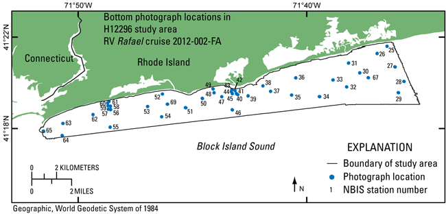
The purpose of this dataset is to release the mid-resolution and full-resolution JPEG images of bottom photographs acquired with a small SEABOSS system during USGS survey 2012-002-FA in the H12296 study area in Block Island Sound.

How was the data set created?

  1. From what previous works were the data drawn?
    Information unavailable from original metadata. (source 1 of 1)
    Information unavailable from original metadata. Assumed to be USGS., unknown, Information unavailable from original metadata..

    Other_Citation_Details:
    The source information was incomplete and had to be modified to meet the standard.
    Type_of_Source_Media: Information unavailable from original metadata.
    Source_Contribution:
    The Mini SEABOSS (SEABed Observation and Sampling System) was designed specifically for the USGS Woods Hole Science Center's 26-foot research boat Rafael. This system is equipped with two video cameras (Subsea Video System color CCD camera and high-resolution B/W CCD camera), a digital still camera (Canon G12), and a Van Veen grab sampler. This system, weighing approximately 201 lbs, can be used to depths up to 40 meters. The grab itself is raised and lowered with a 3/16-inch Aramid fiber winch-line with a breaking strength of 5,600 pounds. The davit is secured when the Mini SEABOSS is in the water. The electrical cable is on a spring-wound take-up reel with electrical slip rings that is mounted aft of the sampler. This arrangement protects the 0.38-in. multi-conductor cable and keeps the Mini SEABOSS correctly oriented with the boat. This multi-conductor cable enables communication between the ship's lab and the Mini SEABOSS system. The digital camera, a Canon G12, is mounted in a machined Delrin housing with a flat port and is set for 3648 x 2736 pixel images at the "fine" setting for compression. Photographs are stored in the camera on an SD card. The system also has a 50 Watt/second flash unit (Ikelite Digital Substrobe DS51) powered by 8 AA batteries. Two battery-powered lasers are set 15 cm apart for scale measurements. The red laser dots can usually be seen in the photo depending on the bottom type and the distance to the sea floor. A third battery powered laser is positioned at an angle so that when it intersects the other lasers, the Mini SEABOSS is at the optimum height off the bottom for a still photograph. The camera is set to a manual focus and set to a default focus distance once the camera is powered up. The default focus distance is slightly less than the optimum height above the seafloor to account for optical distortion under water.
  2. How were the data generated, processed, and modified?
    Date: 2012 (process 1 of 8)
    The USGS Mini SEABOSS system was deployed to capture still photos and video in the H12296 study area in Block Island Sound. This system was used to obtain 3 to 8 still photographs at each station as the R/V Rafael drifted over the seabed for 2 to 5 minutes. The third laser on the system was set to an angle such that the optimum photograph height was 60 cm. The default focus on the camera was set to 50 cm. The imaged area is most often within .3 to 1 meter from left to right. Other camera settings are as follows: aperture is set at f/8; shutter speed is 1/251 second; standard color mode. The camera time is set to GMT. A total of 214 images of the seafloor were acquired. Although the images themselves have no georeferencing information, the navigation related to each photograph is available in an Esri formatted shapefile: 2012-002_023botphotos.shp. These data can be downloaded from the following locations: http://pubs.usgs.gov/of/2014/1018/data/botphotos/2012-002_296botphotos.zip; http://pubs.usgs.gov/of/2014/1018/html/catalog.html. Person who carried out this activity:
    Dann Blackwood
    U.S. Geological Survey
    Photographer
    384 Woods Hole Road
    Woods Hole, MA
    USA

    (508) 548-8700 x2227 (voice)
    (508) 457-2310 (FAX)
    dblackwood@usgs.gov
    Date: 2012 (process 2 of 8)
    The digital images were recorded on an SD memory card within the camera. The images were transferred from the camera to a hard drive at the end of each day in the field. This transfer was accomplished by removing the card from the camera and using a card reader connected to a Windows laptop. Person who carried out this activity:
    Larry Poppe
    U.S. Geological Survey
    Geologist
    384 Woods Hole Road
    Woods Hole, MA
    USA

    (508) 548-8700 x2314 (voice)
    (508) 457-2310 (FAX)
    lpoppe@usgs.gov
    Date: 2012 (process 3 of 8)
    The original JPEG images were renamed from the sequential, camera automatic filename to a filename reflecting station location. This was done for each individual file in Windows Explorer. Person who carried out this activity:
    Katherine McMullen
    U.S. Geological Survey
    Field and Laboratory Technician
    384 Woods Hole Road
    Woods Hole, MA
    USA

    508-548-8700 x2277 (voice)
    508-457-2310 (FAX)
    kmcmullen@usgs.gov
    Date: 2012 (process 4 of 8)
    The full-resolution JPEG images (3648 x 2736 pixels) were downsampled using Photoshop CS to create JPEG images with medium resolution (600 x 450 pixels) and thumbnails (150 x 113 pixels). The filename indicates the image resolution. For instance, the full-resolution JPEG image, nbis31a.jpg, was downsampled to produce medium-resolution JPEG image, nbis31amr.jpg, and thumbnail nbis31atn.jpg. Person who carried out this activity:
    Katherine McMullen
    U.S. Geological Survey
    Field and Laboratory Technician
    384 Woods Hole Road
    Woods Hole, MA
    USA

    (508) 548-8700 x2277 (voice)
    (508) 457-2310 (FAX)
    kmcmullen@usgs.gov
    Date: 04-Dec-2015 (process 5 of 8)
    Edits to the metadata were made to fix any errors that MP v 2.9.32 flagged. This is necessary to enable the metadata to be successfully harvested for various data catalogs. In some cases, this meant adding text "Information unavailable" or "Information unavailable from original metadata" for those required fields that were left blank. Other minor edits were probably performed (title, publisher, publication place, etc.). The source information was incomplete and had to be modified to meet the standard. The metadata date (but not the metadata creator) was edited to reflect the date of these changes. The metadata available from a harvester may supersede metadata bundled within a download file. Compare the metadata dates to determine which metadata file is most recent. Person who carried out this activity:
    U.S. Geological Survey
    Attn: VeeAnn A. Cross
    Marine Geologist
    384 Woods Hole Rd.
    Woods Hole, MA

    508-548-8700 x2251 (voice)
    508-457-2310 (FAX)
    vatnipp@usgs.gov
    Date: 20-Jul-2018 (process 6 of 8)
    USGS Thesaurus keywords added to the keyword section. Person who carried out this activity:
    U.S. Geological Survey
    Attn: VeeAnn A. Cross
    Marine Geologist
    384 Woods Hole Road
    Woods Hole, MA

    508-548-8700 x2251 (voice)
    508-457-2310 (FAX)
    vatnipp@usgs.gov
    Date: 18-Nov-2019 (process 7 of 8)
    Crossref DOI link was added as the first link in the metadata. Person who carried out this activity:
    U.S. Geological Survey
    Attn: VeeAnn A. Cross
    Marine Geologist
    384 Woods Hole Road
    Woods Hole, MA

    508-548-8700 x2251 (voice)
    508-457-2310 (FAX)
    vatnipp@usgs.gov
    Date: 08-Sep-2020 (process 8 of 8)
    Added keywords section with USGS persistent identifier as theme keyword. Person who carried out this activity:
    U.S. Geological Survey
    Attn: VeeAnn A. Cross
    Marine Geologist
    384 Woods Hole Road
    Woods Hole, MA

    508-548-8700 x2251 (voice)
    508-457-2310 (FAX)
    vatnipp@usgs.gov
  3. What similar or related data should the user be aware of?
    Blackwood, D.S., and Parolski, K.F., 2001, Seabed observation and sampling system: Sea Technology February 2001, v. 44, no. 2.

    Valentine, P.C., Blackwood, D.S., and Parolski, K.F., 2002, Seabed observation and sampling system: Fact Sheet 142-00, U.S. Geological Survey, Reston, VA.

    Online Links:

    Poppe, L.J., Danforth, W.W., McMullen, K.Y., Blankenship, M.A., Glomb, K.A., Wright, D.B., and Smith, S.M., 2012, Sea-floor character and sedimentary processes of Block Island Sound, offshore Rhode Island: Open-File Report 2012-1005, U.S. Geological Survey, Reston, VA.

    Online Links:

    Other_Citation_Details: DVD-ROM
    McMullen, K.Y., Poppe, L.J., Ackerman, S.D., Blackwood, D.S., Lewit, P.G., and Parker, C.E., 2013, Sea-floor geology in northeastern Block Island Sound, Rhode Island: Open-File Report 2013-1003, U.S. Geological Survey, Reston, VA.

    Online Links:

    Other_Citation_Details: DVD-ROM

How reliable are the data; what problems remain in the data set?

  1. How well have the observations been checked?
  2. How accurate are the geographic locations?
  3. How accurate are the heights or depths?
  4. Where are the gaps in the data? What is missing?
    All 214 images of the sea floor in the H12296 study area collected on R/V Rafael cruise 2012-002-FA with the mini SEABOSS system are included. Other photographs were collected during cruise 2012-002-FA that lie outside the study area. The file-naming convention used includes a four-letter abbreviation for the study area (nbis), followed by the station number, the picture letter from that station, and the resolution if it is not full resolution (tn for thumbnail, mr for medium resolution). For instance, nbis31bmr.jpg is an image from northern Block Island Sound study area, station 31, picture b, in medium resolution. Photographs collected during the same 2012-002-FA cruise in a different study area are not included in this dataset, which account for an incomplete sequence of station numbers.
  5. How consistent are the relationships among the observations, including topology?
    Information unavailable from original metadata.

How can someone get a copy of the data set?

Are there legal restrictions on access or use of the data?
Access_Constraints: None
Use_Constraints:
Public domain data from the U.S. Government are freely redistributable with proper metadata and source attribution. Please recognize the U.S. Geological Survey (USGS) as the source of this information.
  1. Who distributes the data set? (Distributor 1 of 1)
    Larry Poppe
    U.S. Geological Survey
    Geologist
    384 Woods Hole Road
    Woods Hole, MA
    USA

    (508) 548-8700 x2314 (voice)
    (508) 457-2310 (FAX)
    lpoppe@usgs.gov
  2. What's the catalog number I need to order this data set? Downloadable Data: WinZipped files of medium-resolution images (45 MB).
  3. What legal disclaimers am I supposed to read?
    Neither the U.S. Government, the Department of the Interior, nor the USGS, nor the National Oceanic and Atmospheric Administration (NOAA), nor any of their employees, contractors, or subcontractors, make any warranty, express or implied, nor assume any legal liability or responsibility for the accuracy, completeness, or usefulness of any information, apparatus, product, or process disclosed, nor represent that its use would not infringe on privately owned rights. The act of distribution shall not constitute any such warranty, and no responsibility is assumed by the USGS or NOAA in the use of these data or related materials. Any use of trade, product, or firm names is for descriptive purposes only and does not imply endorsement by the U.S. Government.
  4. How can I download or order the data?
  5. What hardware or software do I need in order to use the data set?
    These data are available as JPEG images. To utilize these data, the user must have an image viewer capable of opening JPEG images.

Who wrote the metadata?

Dates:
Last modified: 16-Nov-2021
Metadata author:
Katherine McMullen
U.S. Geological Survey
Field and Laboratory Technician
384 Woods Hole Road
Woods Hole, MA
USA

(508) 548-8700 x2277 (voice)
(508) 457-2310 (FAX)
whsc_data_contact@usgs.gov
Contact_Instructions:
The metadata contact email address is a generic address in the event the metadata contact is no longer with the USGS or the email is otherwise invalid.
Metadata standard:
FGDC Content Standards for Digital Geospatial Metadata (FGDC-STD-001-1998)

This page is <https://cmgds.marine.usgs.gov/catalog/whcmsc/open_file_report/ofr2014-1018/2012-002_296bphotographs_md.faq.html>
Generated by mp version 2.9.50 on Tue Nov 16 10:06:51 2021