Core summary descriptions created in LogPlot 7 for 20 cores from offshore Puerto Rico and the U.S. Virgin Islands collected by the U.S. Geological Survey in 2008 (2008CoreSummaryDescriptions, JPEG image format)

Metadata also available as - [Questions & Answers] - [Parseable text] - [XML]

Metadata:

Identification_Information:
Citation:
Citation_Information:
Originator: U.S. Geological Survey
Publication_Date: 2014
Title:
Core summary descriptions created in LogPlot 7 for 20 cores from offshore Puerto Rico and the U.S. Virgin Islands collected by the U.S. Geological Survey in 2008 (2008CoreSummaryDescriptions, JPEG image format)
Edition: 1.0
Series_Information:
Series_Name: Open-File Report
Issue_Identification: 2014-1227
Publication_Information:
Publication_Place: Woods Hole Coastal and Marine Science Center, Woods Hole, MA
Publisher: U.S. Geological Survey, Coastal and Marine Geology Program
Online_Linkage: https://doi.org/10.3133/ofr20141227
Online_Linkage: Online_Linkage: Larger_Work_Citation:
Citation_Information:
Originator: Shannon K. Hoy
Originator: Jason D. Chaytor
Originator: Uri S. ten Brink
Publication_Date: 2014
Title: Core Data From Offshore Puerto Rico and the U.S. Virgin Islands
Edition: 1.0
Series_Information:
Series_Name: Open-File Report
Issue_Identification: 2014-1227
Publication_Information:
Publication_Place: Reston, VA
Publisher: U.S. Geological Survey
Online_Linkage: https://doi.org/10.3133/ofr20141227
Description:
Abstract:
In 2008, as a collaborative effort between Woods Hole Oceanographic Institution and the U.S. Geological Survey, 20 giant gravity cores were collected from areas surrounding Puerto Rico and the U.S. Virgin Islands. The regions sampled have had many large earthquake and landslide events, some of which are believed to have triggered tsunamis. The objective of this coring cruise, carried out aboard the National Oceanic and Atmospheric Administration research vessel Seward Johnson, was to determine the age of several substantial slope failures and seismite layers near Puerto Rico in an effort to map their temporal distribution. Data gathered from the cores collected in 2008 and 11 archive cores from the Lamont-Doherty Earth Observatory are included in this report. These data include lithologic logs, core summary sheets, x-ray fluorescence, wet-bulk density, magnetic susceptibility, grain-size analyses, radiographs, and radiocarbon age dates.
Purpose:
This data set contains summary descriptions (JPEG) for the 20 cores collected in 2008 on the R/V Seward Johnson during field activity 2008-008-FA. These descriptions were created in LogPlot 7 and represent descriptive core information including: color, lithology, samples taken, mean grain-size, grain-size distribution, wet bulk density, and magnetic susceptibility.
Supplemental_Information:
For more information on the USGS cruise, please see: https://cmgds.marine.usgs.gov/fan_info.php?fan=2008-008-FA
Time_Period_of_Content:
Time_Period_Information:
Range_of_Dates/Times:
Beginning_Date: 20080318
Ending_Date: 20080324
Currentness_Reference: ground condition; cores collected in 2008
Status:
Progress: Complete
Maintenance_and_Update_Frequency: None planned
Spatial_Domain:
Bounding_Coordinates:
West_Bounding_Coordinate: -67.0795
East_Bounding_Coordinate: -64.822830
North_Bounding_Coordinate: 19.17558
South_Bounding_Coordinate: 17.552930
Keywords:
Theme:
Theme_Keyword_Thesaurus: USGS Metadata Identifier
Theme_Keyword: USGS:e7c7c466-dce5-4c32-a3ba-5785017e6011
Theme:
Theme_Keyword_Thesaurus: None
Theme_Keyword: U.S. Geological Survey
Theme_Keyword: USGS
Theme_Keyword: Woods Hole Coastal and Marine Science Center
Theme_Keyword: WHCMSC
Theme_Keyword: Coastal and Marine Geology Program
Theme_Keyword: CMGP
Theme_Keyword: cores
Theme_Keyword: gravity cores
Theme_Keyword: Cruise ID SJH08008
Theme_Keyword: WHSC field activity 2008-008-FA
Theme_Keyword: R/V Seward Johnson
Theme_Keyword: core summary descriptions
Theme_Keyword: LogPlot 7
Theme_Keyword: JPEG
Theme:
Theme_Keyword_Thesaurus: ISO 19115 Topic Category
Theme_Keyword: oceans
Theme_Keyword: geoscientificInformation
Theme:
Theme_Keyword_Thesaurus: USGS Thesaurus
Theme_Keyword: drilling and coring
Theme_Keyword: field activity logs
Place:
Place_Keyword_Thesaurus: None
Place_Keyword: Puerto Rico
Place_Keyword: U.S. Virgin Islands
Place_Keyword: Atlantic
Place_Keyword: Caribbean
Place_Keyword: Caribbean Sea
Place_Keyword: Puerto Rico Trench
Place_Keyword: Mona Passage
Place_Keyword: Arecibo Amphitheater
Place_Keyword: Loiza Amphitheater
Place_Keyword: Whiting Basin
Place_Keyword: Virgin Island Basin
Place_Keyword: Anegada Passage
Access_Constraints: None
Use_Constraints:
The Public domain data from the U.S. Government are freely redistributable with proper metadata and source attribution. Please recognize the U.S. Geological Survey as the originator of the dataset.
Point_of_Contact:
Contact_Information:
Contact_Person_Primary:
Contact_Person: Jason D. Chaytor
Contact_Organization: U.S. Geological Survey
Contact_Position: Research Geologist
Contact_Address:
Address_Type: mailing and physical address
Address: 384 Woods Hole Road
City: Woods Hole
State_or_Province: MA
Postal_Code: 02543-1598
Contact_Voice_Telephone: (508) 548-8700 x2351
Contact_Facsimile_Telephone: (508) 457-2310
Contact_Electronic_Mail_Address: jchaytor@usgs.gov
Browse_Graphic:
Browse_Graphic_File_Name: Browse_Graphic_File_Description:
Example of core summary description created in LogPlot 7 from core SJ8-5GGC
Browse_Graphic_File_Type: JPEG
Native_Data_Set_Environment:
Microsoft Windows Vista Version 6.1 (Build 7601) Service Pack 1; ESRI ArcCatalog 9.3.1.4095
Data_Quality_Information:
Attribute_Accuracy:
Attribute_Accuracy_Report:
Files were double checked that filename matched the core that was described and that all data came from the same core.
Logical_Consistency_Report:
The naming convention is: CoreName_summary. The core name is the core number paired with the abbreviation GGC, which stands for giant gravity corer (##GGC). Summary stands for summary descriptions created in LogPlot 7.
Completeness_Report:
This report contains all of the summary descriptions from the 2008 SJ8 cores. There were 20 cores with summary descriptions: 5GGC, 7GGC, 8GGC, 9GGC, 10GGC, 12GGC, 13GGC, 17GGC, 18GGC, 20GGC, 21GGC, 22GGC, 23GGC, 24GGC, 28GGC, 31GGC, 33GGC, 34GGC, 38GGC, and 40GGC. There are missing numbers due to failed core attempts or a site that only yielded a bag samples. Also, not all fields are applicable for each core. For some cores, some samples were not taken or tests not performed, therefore there is no data represented in the respective fields. 10GGC, 12GGC, 34GGC and 40GGC lack grain-size information. 28GGC lacks multi-sensor core logger data (wet bulk density and magnetic susceptibility).
Lineage:
Source_Information:
Source_Citation:
Citation_Information:
Originator: Andrews, B.D.
Originator: ten Brink, U.S.
Originator: Danforth, W.W.
Originator: Chaytor, J.D.
Originator: Granja Burna, J.L.
Originator: Llanes Estrada, P.
Originator: Carbo-Gorosabel, A.
Publication_Date: 2014
Title:
Bathymetric Terrain Model of Puerto Rico Trench and the Northeast Caribbean Region: Marine Geological Investigations
Edition: 1.0
Series_Information:
Series_Name: Open-File Report
Issue_Identification: 2013-1125
Publication_Information:
Publication_Place: Reston, VA
Publisher: U.S. Geological Survey
Online_Linkage: https://doi.org/10.3133/ofr20131125
Type_of_Source_Media: Open-File Report
Source_Time_Period_of_Content:
Time_Period_Information:
Single_Date/Time:
Calendar_Date: 2014
Source_Currentness_Reference: publication date
Source_Citation_Abbreviation: PR Bathymetry
Source_Contribution:
The 50 meter grid was used for depth information in the sample area
Source_Information:
Source_Citation:
Citation_Information:
Originator: Shannon K. Hoy
Originator: Jason D. Chaytor
Originator: Uri S. ten Brink
Publication_Date: 2014
Title: Core data from offshore Puerto Rico and the U.S. Virgin Islands
Edition: 1.0
Series_Information:
Series_Name: Open File Report
Issue_Identification: 2014-1227
Publication_Information:
Publication_Place: Reston, VA
Publisher: U.S. Geological Survey
Online_Linkage: https://pubs.usgs.gov/of/2014/1227/
Type_of_Source_Media: physical samples
Source_Time_Period_of_Content:
Time_Period_Information:
Range_of_Dates/Times:
Beginning_Date: 20080317
Ending_Date: 20080324
Source_Currentness_Reference: ground condition of core collection
Source_Citation_Abbreviation: GGC
Source_Contribution:
The gravity cores collected during U.S. Geological Survey field activity 2008-008-FA. The Woods Hole Oceanographic Giant Gravity Corer (GGC) was used to collect the 20 cores in 2008. The gravity corer is a large diameter (10 centimeter) sampler that collects cores up to 6.5 meters in length. During field activity 2008-008-FA the corer was not rigged with liner longer than approximately 3 meters. Although cores were attempted at 40 core sites, core was recovered at only 20 sites. Seven additional sites yielded only samples (bagged) from the core catcher or cutting head. Of the 20 successful cores, three also have cutter/catcher bag samples.
Process_Step:
Process_Description:
Jason D. Chaytor examined the cores at the U.S. Geological Survey in Woods Hole at a centimeter scale. Hand-written observations were made of sediment type, notable bioturbation, shells, texture, color, stiffness, and additional features described in the core field descriptions.
Source_Used_Citation_Abbreviation: GGC
Process_Date: 2009
Source_Produced_Citation_Abbreviation: FieldDescriptions
Process_Contact:
Contact_Information:
Contact_Person_Primary:
Contact_Person: Jason D. Chaytor
Contact_Organization: U.S. Geological Survey
Contact_Position: Research Geologist
Contact_Address:
Address_Type: mailing and physical address
Address: 384 Woods Hole Road
City: Woods Hole
State_or_Province: MA
Postal_Code: 02543-1598
Contact_Voice_Telephone: (508) 548-8700 x2351
Contact_Facsimile_Telephone: (508) 457-2310
Contact_Electronic_Mail_Address: jchaytor@usgs.gov
Process_Step:
Process_Description:
Cores were tested with a GEOTEK MSCL-S multi-sensor core logger for wet-bulk density and magnetic susceptibility.
Process_Date: unknown
Source_Produced_Citation_Abbreviation: MSCL
Process_Contact:
Contact_Information:
Contact_Person_Primary:
Contact_Person: Brian Buczkowski
Contact_Organization: U.S. Geological Survey
Contact_Position: Geological Samples Curator and Data Librarian
Contact_Address:
Address_Type: mailing and physical address
Address: 384 Woods Hole Road
City: Woods Hole
State_or_Province: MA
Postal_Code: 02543-1598
Contact_Voice_Telephone: (508) 548-8700 x2361
Contact_Facsimile_Telephone: (508) 457-2310
Contact_Electronic_Mail_Address: bbuczkowski@usgs.gov
Process_Step:
Process_Description:
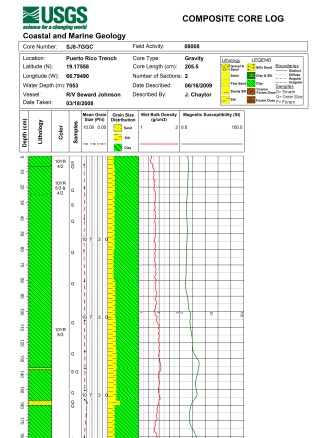
Data from hand-written logs, grain-size and multi-sensor core logging were entered into LogPlot 7 for each core. LogPlot 7 created a mean-grain size plot, as well as graphically represented the grain-size distribution. LogPlot 7 also created plots for the wet-bulk density and magnetic susceptibility data. Hand-written logs were graphically represented by lithology symbols, color text, and location where samples were taken.
Source_Used_Citation_Abbreviation: FieldDescriptions
Source_Used_Citation_Abbreviation: Grain-Size
Source_Used_Citation_Abbreviation: MSCL
Process_Date: unknown
Process_Contact:
Contact_Information:
Contact_Person_Primary:
Contact_Person: Shannon K. Hoy
Contact_Organization: U.S. Geological Survey
Contact_Position: Research Associate
Contact_Address:
Address_Type: mailing and physical address
Address: 384 Woods Hole Road
City: Woods Hole
State_or_Province: MA
Postal_Code: 02543-1598
Contact_Voice_Telephone: (508) 548-8700 x2297
Contact_Facsimile_Telephone: (508) 457-2310
Contact_Electronic_Mail_Address: shoy@usgs.gov
Process_Step:
Process_Description:
JPEG images of the summary descriptions were exported from LogPlot 7.
Process_Date: unknown
Process_Contact:
Contact_Information:
Contact_Person_Primary:
Contact_Person: Shannon K. Hoy
Contact_Organization: U.S. Geological Survey
Contact_Position: Research Associate
Contact_Address:
Address_Type: mailing and physical address
Address: 384 Woods Hole Road
City: Woods Hole
State_or_Province: MA
Postal_Code: 02543-1598
Contact_Voice_Telephone: (508) 548-8700 x2297
Contact_Facsimile_Telephone: (508) 457-2310
Contact_Electronic_Mail_Address: shoy@usgs.gov
Process_Step:
Process_Description:
Edits to the metadata were made to fix any errors that MP v 2.9.36 flagged. This is necessary to enable the metadata to be successfully harvested for various data catalogs. In some cases, this meant adding text "Information unavailable" or "Information unavailable from original metadata" for those required fields that were left blank. Other minor edits were probably performed (title, publisher, publication place, etc.). Added additional online links in the Identification section. Updated a cross-reference citation to go from "in prep" to published. Fixed a link to data in the entity and attribute overview section. The metadata date (but not the metadata creator) was edited to reflect the date of these changes. The metadata available from a harvester may supersede metadata bundled within a download file. Compare the metadata dates to determine which metadata file is most recent.
Process_Date: 20171003
Process_Contact:
Contact_Information:
Contact_Organization_Primary:
Contact_Organization: U.S. Geological Survey
Contact_Person: VeeAnn A. Cross
Contact_Position: Marine Geologist
Contact_Address:
Address_Type: Mailing and Physical
Address: 384 Woods Hole Road
City: Woods Hole
State_or_Province: MA
Postal_Code: 02543-1598
Contact_Voice_Telephone: 508-548-8700 x2251
Contact_Facsimile_Telephone: 508-457-2310
Contact_Electronic_Mail_Address: vatnipp@usgs.gov
Process_Step:
Process_Description: USGS Thesaurus keywords added to the keyword section.
Process_Date: 20180720
Process_Contact:
Contact_Information:
Contact_Organization_Primary:
Contact_Organization: U.S. Geological Survey
Contact_Person: VeeAnn A. Cross
Contact_Position: Marine Geologist
Contact_Address:
Address_Type: Mailing and Physical
Address: 384 Woods Hole Road
City: Woods Hole
State_or_Province: MA
Postal_Code: 02543-1598
Contact_Voice_Telephone: 508-548-8700 x2251
Contact_Facsimile_Telephone: 508-457-2310
Contact_Electronic_Mail_Address: vatnipp@usgs.gov
Process_Step:
Process_Description:
Added keywords section with USGS persistent identifier as theme keyword.
Process_Date: 20200908
Process_Contact:
Contact_Information:
Contact_Organization_Primary:
Contact_Organization: U.S. Geological Survey
Contact_Person: VeeAnn A. Cross
Contact_Position: Marine Geologist
Contact_Address:
Address_Type: Mailing and Physical
Address: 384 Woods Hole Road
City: Woods Hole
State_or_Province: MA
Postal_Code: 02543-1598
Contact_Voice_Telephone: 508-548-8700 x2251
Contact_Facsimile_Telephone: 508-457-2310
Contact_Electronic_Mail_Address: vatnipp@usgs.gov
Entity_and_Attribute_Information:
Overview_Description:
Entity_and_Attribute_Overview:
Although the core summary JPEG images are not geospatial, they are related to the core locations which are available in the PRcore_locations shapefile available from https://pubs.usgs.gov/of/2014/1227/data/1-CoreLocations/PRcore_locations.zip
The JPEG images graphically represent different types of collected data:
>Depth (cm)
Depth of core in centimeters Units of measure: centimeters
>Lithology
Symbols representing the lithology of the core. No data is represented by blank intervals. Symbology is denoted in the legend in the JPEG headers.
>Color
Color of core interval based on the Munsell Soil Color Chart (2010).
>Samples
What and where samples were taken. S=Smear Slide G= Grain-size
> Mean Grain Size (Phi)
average grain size at a specified depth. Unites of measure: phi
>Grain Size Distribution
graphical representation of percentage of grain-size that is sand, silt or clay, at a specified depth. Units of measure: percent
>Wet Bulk Density
Plot of wet bulk density collected by the GEOTEK MSCL-S multi-sensor core logger. Units of measure: g/cm3
>Magnetic Susceptibility
plots of magnetic susceptibility of core collected by a GEOTEK MSCL-S multi-sensor core logger Units of measure: SI
Entity_and_Attribute_Detail_Citation: U.S. Geological Survey
Distribution_Information:
Distributor:
Contact_Information:
Contact_Person_Primary:
Contact_Person: Jason D. Chaytor
Contact_Organization: U.S. Geological Survey
Contact_Position: Research Geologist
Contact_Address:
Address_Type: mailing and physical address
Address: 384 Woods Hole Road
City: Woods Hole
State_or_Province: MA
Postal_Code: 02543-1598
Contact_Voice_Telephone: (508) 548-8700 x2351
Contact_Facsimile_Telephone: (508) 457-2310
Contact_Electronic_Mail_Address: jchaytor@usgs.gov
Resource_Description: Downloadable Data
Distribution_Liability:
Neither the U.S. Government, the Department of the Interior, nor the USGS, nor any of their employees, contractors, or subcontractors, make any warranty, express or implied, nor assume any legal liability or responsibility for the accuracy, completeness, or usefulness of any information, apparatus, product or process disclosed, nor represent that its use would not infringe on privately owned rights. The act of distribution shall not constitute any such warranty, and no responsibility is assumed by the USGS in the use of these data or related materials. Any use of trade, product, or firm names is for descriptive purposes only and does not imply endorsement by the U.S. Government.
Standard_Order_Process:
Digital_Form:
Digital_Transfer_Information:
Format_Name: JPEG
Format_Version_Number: information not available from original metadata
Format_Specification: joint photographic experts group
Format_Information_Content:
The WinZip version 18 file contains 20 JPEGS of core summary descriptions created in LogPlot 7 of 20 2008 cores from around Puerto Rico and the U.S. Virgin Islands and the associated metadata.
File_Decompression_Technique: Use WinZip 18 or pkUnzip
Transfer_Size: 25
Digital_Transfer_Option:
Online_Option:
Computer_Contact_Information:
Fees: None.
Technical_Prerequisites:
The user must be able to unzip a WinZip18 compressed file as well as view JPEGs.
Metadata_Reference_Information:
Metadata_Date: 20211116
Metadata_Contact:
Contact_Information:
Contact_Organization_Primary:
Contact_Organization: U.S. Geological Survey
Contact_Person: Shannon K. Hoy
Contact_Position: Research Associate II
Contact_Address:
Address_Type: mailing and physical address
Address: 384 Woods Hole Road
City: Woods Hole
State_or_Province: MA
Postal_Code: 02543-1598
Country: United States
Contact_Voice_Telephone: (508) 548-8700 x2297
Contact_Facsimile_Telephone: (508) 457-2310
Contact_Electronic_Mail_Address: whsc_data_contact@usgs.gov
Contact_Instructions:
The metadata contact email address is a generic address in the event the metadata contact is no longer with the USGS or the email is otherwise invalid.
Metadata_Standard_Name: FGDC Content Standards for Digital Geospatial Metadata
Metadata_Standard_Version: FGDC-STD-001-1998
Metadata_Time_Convention: local time
Metadata_Access_Constraints: None
Metadata_Use_Constraints: None

This page is <https://cmgds.marine.usgs.gov/catalog/whcmsc/open_file_report/ofr2014-1227/2008CoreSummaryDescriptionsmeta.html>
Generated by mp version 2.9.50 on Tue Nov 16 10:06:52 2021