TIFF image format of radiographs of gravity cores collected in 2008 by the U.S. Geological Survey around Puerto Rico and the U.S. Virgin Islands and accompanied by CSV and XLS files containing image lists and section information

Metadata also available as - [Outline] - [Parseable text] - [XML]

Frequently anticipated questions:


What does this data set describe?

Title:
TIFF image format of radiographs of gravity cores collected in 2008 by the U.S. Geological Survey around Puerto Rico and the U.S. Virgin Islands and accompanied by CSV and XLS files containing image lists and section information
Abstract:
In 2008, as a collaborative effort between Woods Hole Oceanographic Institution and the U.S. Geological Survey, 20 giant gravity cores were collected from areas surrounding Puerto Rico and the U.S. Virgin Islands. The regions sampled have had many large earthquake and landslide events, some of which are believed to have triggered tsunamis. The objective of this coring cruise, carried out aboard the National Oceanic and Atmospheric Administration research vessel Seward Johnson, was to determine the age of several substantial slope failures and seismite layers near Puerto Rico in an effort to map their temporal distribution. Data gathered from the cores collected in 2008 and 11 archive cores from the Lamont-Doherty Earth Observatory are included in this report. These data include lithologic logs, core summary sheets, x-ray fluorescence, wet-bulk density, magnetic susceptibility, grain-size analyses, radiographs, and radiocarbon age dates.
Supplemental_Information:
For more information on the USGS cruise, please see https://cmgds.marine.usgs.gov/fan_info.php?fan=2008-008-FA
  1. How might this data set be cited?
    U.S. Geological Survey, 2014, TIFF image format of radiographs of gravity cores collected in 2008 by the U.S. Geological Survey around Puerto Rico and the U.S. Virgin Islands and accompanied by CSV and XLS files containing image lists and section information: Open-File Report 2014-1227, U.S. Geological Survey, Coastal and Marine Geology Program, Woods Hole Coastal and Marine Science Center, Woods Hole, MA.

    Online Links:

    This is part of the following larger work.

    Hoy, Shannon K., Chaytor, Jason D., and Uri S. ten Brink, 2014, Core Data From Offshore Puerto Rico and the U.S. Virgin Islands: Open-File Report 2014-1227, U.S. Geological Survey, Reston, VA.

    Online Links:

  2. What geographic area does the data set cover?
    West_Bounding_Coordinate: -67.0795
    East_Bounding_Coordinate: -64.82283
    North_Bounding_Coordinate: 19.17558
    South_Bounding_Coordinate: 17.55293
  3. What does it look like?
    https://pubs.usgs.gov/of/2014/1227/data/4-CoreRadiographs/2008PR_radiograph.jpg (JPEG)
    JPEG image of a sample of a radiograph image.
  4. Does the data set describe conditions during a particular time period?
    Beginning_Date: 18-Mar-2008
    Ending_Date: 24-Mar-2008
    Currentness_Reference:
    ground condition; cores collected in 2008
  5. What is the general form of this data set?
  6. How does the data set represent geographic features?
    1. How are geographic features stored in the data set?
    2. What coordinate system is used to represent geographic features?
  7. How does the data set describe geographic features?
    Entity_and_Attribute_Overview:
    Although the core radiograph images are not geospatial, they are related to the core locations which are available in the PRcore_locations shapefile available from https://pubs.usgs.gov/of/2014/1227/data/1-CoreLocations/PRcore_locations.zip. In addition to the radiograph images, an Excel 2010 spreadsheet is provided with the following columns of information: FileName, Core, Interval(cm), Ruler_inFrame(cm), FrameNum, Notes. A CSV (comma-delimited text) file is also provided with the same columns of information. The FileName is the prefix of the TIFF image, the Core indicates which core the image comes from, the Interval indicates the top and bottom interval in centimeters of the image location within the whole core, the FrameNum indicates the frame number which occurs in the lower portion of each TIFF image, and the Notes field contains additional information as necessary.
    Entity_and_Attribute_Detail_Citation: U.S. Geological Survey

Who produced the data set?

  1. Who are the originators of the data set? (may include formal authors, digital compilers, and editors)
    • U.S. Geological Survey
  2. Who also contributed to the data set?
  3. To whom should users address questions about the data?
    Jason D. Chaytor
    U.S. Geological Survey
    Research Geologist
    384 Woods Hole Rd.
    Woods Hole, MA

    (508) 548-8700 x2351 (voice)
    (508) 457-2310 (FAX)
    jchaytor@usgs.gov

Why was the data set created?

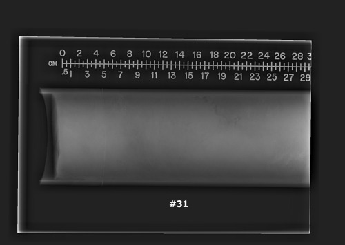
To provide radiographs of some of the cores collected on USGS Field Activity 2008-008. The radiographs highlight sedimentary structures, especially bioturbation and the fine tails of turbidites.

How was the data set created?

  1. From what previous works were the data drawn?
    GGC (source 1 of 1)
    U.S. Geological Survey, 2014, Core data from offshore Puerto Rico and the U.S. Virgin Islands: Open-File Report 2014-1227, U.S. Geological Survey, Reston, VA.

    Online Links:

    Type_of_Source_Media: physical samples
    Source_Contribution:
    The gravity cores collected during U.S. Geological Survey field activity 2008-008-FA. The Woods Hole Oceanographic Giant Gravity Corer (GGC) was used to collect the 20 cores in 2008. The gravity corer is a large diameter (10 centimeter) sampler that collects cores up to 6.5 meters in length. During field activity 2008-008-FA the corer was not rigged with liner longer than approximately 3 meters. Although cores were attempted at 40 core sites, core was recovered at only 20 sites. Seven additional sites yielded only samples (bagged) from the core catcher or cutting head. Of the 20 successful cores, three also have cutter/catcher bag samples.
  2. How were the data generated, processed, and modified?
    Date: 2008 (process 1 of 5)
    Each core was cut into sections on the ship after collection. The cores were then split into halves back onshore. This process step and subsequent process steps were performed by the same person. Person who carried out this activity:
    Jason D. Chaytor
    U.S. Geological Survey
    Research Geologist
    384 Woods Hole Road
    Woods Hole, MA

    (508) 548-8700 x2351 (voice)
    (508) 457-2310 (FAX)
    jchaytor@usgs.gov
    Data sources produced in this process:
    • Split_cores
    Date: 2010 (process 2 of 5)
    Once back onshore, digital x-radiographs of each core section were acquired at Falmouth Hospital (Falmouth, Massachusetts). The x-ray machine took approximately 30 cm interval photos of the cores. Each photo should overlap on each side with the preceding and succeeding interval by a few centimeters. The files were named for the core (ex 5GGC) then the section (1, 2, or 3) and then the interval (1, 2, 3, 4, or 5). The section numbers increase from bottom to top, while the interval numbers increase from top to bottom. The number in the photo is the frame number which increments consecutively from top to bottom. The excel spreadsheet (2008PR_radiographs.xls) give the image filename, the core from which is came, the interval of the total core represented, the frame number, and any additional notes. Within the images, the ruler measurement has a maximum value of 115 cm, so only represents the location within the section, not the core as a whole. For core 5GGC, the bottom-most section of the core is from the core cutter and indicates that in the filename (5GGC_cc_1) as opposed to having a section and interval number.
    *The interval for core 33GGC is approximate because the core ran past the ruler. ** The bottom 47 cm of core 38GGC was not scanned
    An example of a core and the order of the images from top to bottom is as follows:
    
    5GGC_sect2_1
    5GGC_sect2_2
    5GGC_sect2_3
    5GGC_sect2_4
    5GGC_sect2_5
    5GGC_sect1_1
    5GGC_sect1_2
    5GGC_sect1_3
    5GGC_sect1_4
    5GGC_sect1_5
    5GGC_cc_1
    
    Data sources used in this process:
    • Split_cores
    Date: 03-Oct-2017 (process 3 of 5)
    Edits to the metadata were made to fix any errors that MP v 2.9.36 flagged. This is necessary to enable the metadata to be successfully harvested for various data catalogs. In some cases, this meant adding text "Information unavailable" or "Information unavailable from original metadata" for those required fields that were left blank. Other minor edits were probably performed (title, publisher, publication place, etc.). Added additional online links in the Identification section. The source information was incomplete and had to be modified to meet the standard. Fixed a link to data in the entity and attribute overview section. The metadata date (but not the metadata creator) was edited to reflect the date of these changes. The metadata available from a harvester may supersede metadata bundled within a download file. Compare the metadata dates to determine which metadata file is most recent. Person who carried out this activity:
    U.S. Geological Survey
    Attn: VeeAnn A. Cross
    Marine Geologist
    384 Woods Hole Road
    Woods Hole, MA

    508-548-8700 x2251 (voice)
    508-457-2310 (FAX)
    vatnipp@usgs.gov
    Date: 20-Jul-2018 (process 4 of 5)
    USGS Thesaurus keywords added to the keyword section. Person who carried out this activity:
    U.S. Geological Survey
    Attn: VeeAnn A. Cross
    Marine Geologist
    384 Woods Hole Road
    Woods Hole, MA

    508-548-8700 x2251 (voice)
    508-457-2310 (FAX)
    vatnipp@usgs.gov
    Date: 08-Sep-2020 (process 5 of 5)
    Added keywords section with USGS persistent identifier as theme keyword. Person who carried out this activity:
    U.S. Geological Survey
    Attn: VeeAnn A. Cross
    Marine Geologist
    384 Woods Hole Road
    Woods Hole, MA

    508-548-8700 x2251 (voice)
    508-457-2310 (FAX)
    vatnipp@usgs.gov
  3. What similar or related data should the user be aware of?

How reliable are the data; what problems remain in the data set?

  1. How well have the observations been checked?
    Due to the confusing naming convention, these images were checked over and over to make sure the naming convention matched the actual interval being described.
  2. How accurate are the geographic locations?
  3. How accurate are the heights or depths?
  4. Where are the gaps in the data? What is missing?
    These data represent all the cores that were radiographed. Some cores were not radiographed due to core length and (or) time constraints. Radiographs are available for cores 5, 7, 8, 9, 13, 17, 18, 20, 21, 22, 33, 38, and 40. Core 33GGC ran past the ruler so the last section interval is approximated. The bottom section of core 38GGC was not scanned.
  5. How consistent are the relationships among the observations, including topology?
    The file naming convention is as follows: CCCC_SSSSS_I. CCCC is the core number (ie 5GGC), SSSSS is the section number (ie sect1), and I is the interval number (ie 1). Section number increase from bottom of the core to the top of the core, while interval numbers increase from the top of the core to the bottom and start over at 1 in each section. The exception to this naming convention is the additional file in core 5GGC, which is the core cutter section at the very bottom of the core and has the filename 5GGC_cc_1. Instead of offering a composite JPEG with all of the individual intervals compiled and aligned, the radiographs are offered as individual intervals. This is due to the fact that when the radiographs are taken, the outer edges decrease in accuracy and therefore lying one edge on top of the other creates inaccurate composites.
    
    
    An example of a core and the order of the images from top to bottom is as follows:
    
    5GGC_sect2_1
    5GGC_sect2_2
    5GGC_sect2_3
    5GGC_sect2_4
    5GGC_sect2_5
    5GGC_sect1_1
    5GGC_sect1_2
    5GGC_sect1_3
    5GGC_sect1_4
    5GGC_sect1_5
    5GGC_cc_1
    

How can someone get a copy of the data set?

Are there legal restrictions on access or use of the data?
Access_Constraints: None.
Use_Constraints:
The Public domain data from the U.S. Government are freely redistributable with proper metadata and source attribution. Please recognize the U.S. Geological Survey as the originator of the dataset.
  1. Who distributes the data set? (Distributor 1 of 1)
    Jason D. Chaytor
    U.S. Geological Survey
    Research Geologist
    384 Woods Hole Road
    Woods Hole, MA

    (508) 548-8700 x2351 (voice)
    (508) 457-2310 (FAX)
    jchaytor@usgs.gov
  2. What's the catalog number I need to order this data set? Downloadable Data
  3. What legal disclaimers am I supposed to read?
    Neither the U.S. Government, the Department of the Interior, nor the USGS, nor any of their employees, contractors, or subcontractors, make any warranty, express or implied, nor assume any legal liability or responsibility for the accuracy, completeness, or usefulness of any information, apparatus, product or process disclosed, nor represent that its use would not infringe on privately owned rights. The act of distribution shall not constitute any such warranty, and no responsibility is assumed by the USGS in the use of these data or related materials. Any use of trade, product, or firm names is for descriptive purposes only and does not imply endorsement by the U.S. Government.
  4. How can I download or order the data?
    • Availability in digital form:
      Data format: The zip file (WinZip version18) contains the individual radiograph TIFF images of intervals from each core x-rayed, an Excel 2010 spreadsheet containing the order and information for the images, and a CSV file containing the same information as the Excel spreadsheet, along with FGDC metadata. in format TIFF (version tell software and version used to create image) TIFF image format Size: 71
      Network links: https://pubs.usgs.gov/of/2014/1227/data/4-CoreRadiographs/2008PR_radiographs.zip
      Data format: The zip file (WinZip version18) contains the individual radiograph TIFF images of intervals from each core x-rayed, an Excel 2010 spreadsheet containing the order and information for the images, and a CSV file containing the same information as the Excel spreadsheet, along with FGDC metadata. in format CSV (version Excel 2010) comma separated values Size: 71
      Network links: https://pubs.usgs.gov/of/2014/1227/data/4-CoreRadiographs/2008PR_radiographs.zip
      Data format: The zip file (WinZip version18) contains the individual radiograph TIFF images of intervals from each core x-rayed, an Excel 2010 spreadsheet containing the order and information for the images, and a CSV file containing the same information as the Excel spreadsheet, along with FGDC metadata. in format XLS (version Excel 2010) MS Excel Format Size: 71
      Network links: https://pubs.usgs.gov/of/2014/1227/data/4-CoreRadiographs/2008PR_radiographs.zip
    • Cost to order the data: None.

  5. What hardware or software do I need in order to use the data set?
    The end user must be capable of uncompressing a zip file and viewing a TIFF image.

Who wrote the metadata?

Dates:
Last modified: 16-Nov-2021
Metadata author:
U.S. Geological Survey
Attn: Shannon Hoy
384 Woods Hole Road
Woods Hole, MA

(508) 548-8700 x2297 (voice)
(508) 457-2310 (FAX)
whsc_data_contact@usgs.gov
Contact_Instructions:
The metadata contact email address is a generic address in the event the metadata contact is no longer with the USGS or the email is otherwise invalid.
Metadata standard:
FGDC Content Standards for Digital Geospatial Metadata (FGDC-STD-001-1998)

This page is <https://cmgds.marine.usgs.gov/catalog/whcmsc/open_file_report/ofr2014-1227/2008PR_radiographsmeta.faq.html>
Generated by mp version 2.9.50 on Tue Nov 16 10:06:52 2021