Online Links:
Online Links:
| Formal codeset | |
|---|---|
| Codeset Name: | Polygon |
| Codeset Source: | Esri |
| Formal codeset | |
|---|---|
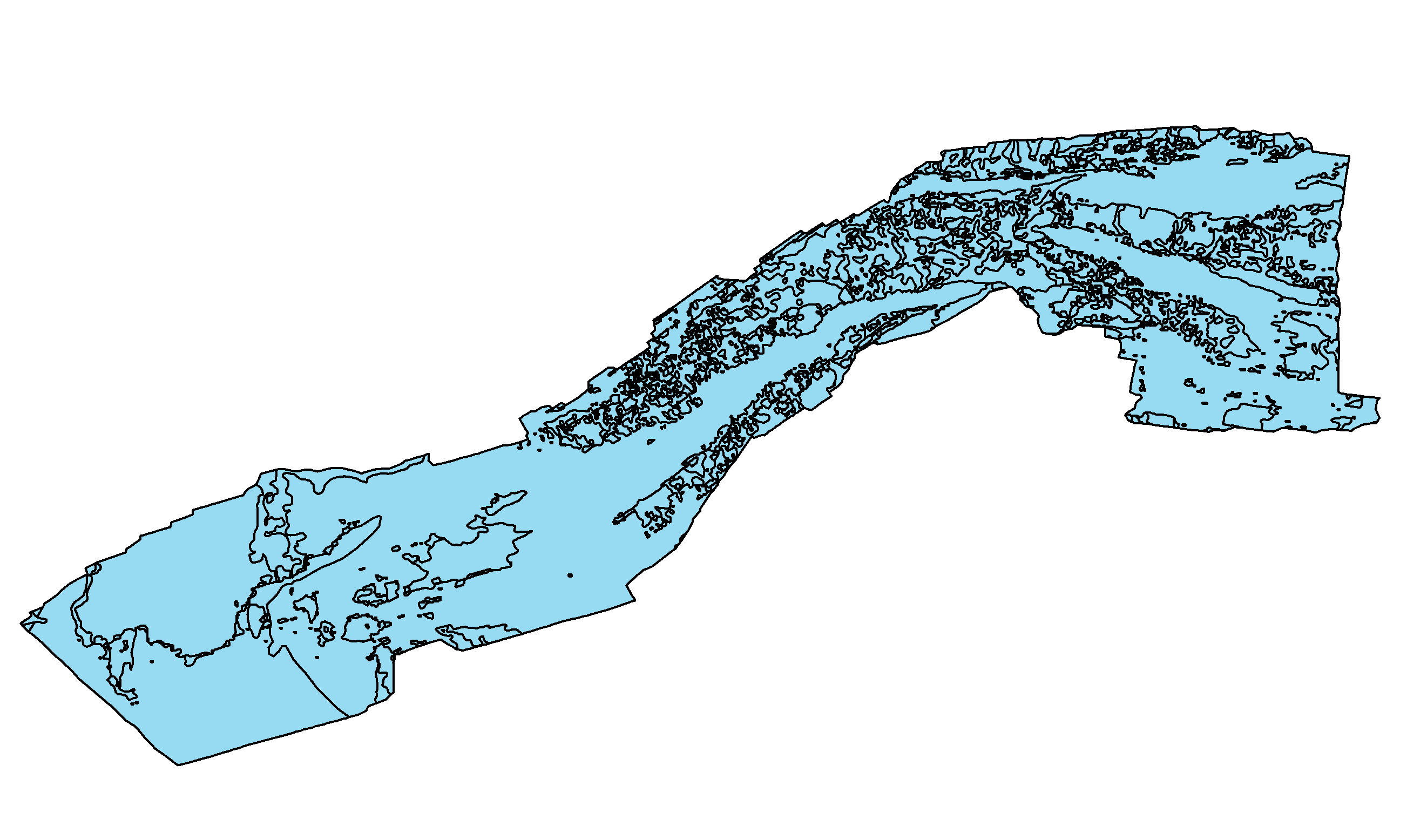
| Codeset Name: | Qdt - Pleistocene glacial till and ice contact deposits - Drift composed of poorly sorted mud, sand, gravel, and boulders, that produce rugged topography where they crop out at the seafloor. While seismic penetration is typically limited, these units produce chaotic reflectors with common diffraction hyperbolae. Underlies Ut and Ur, and in places overlie the fluvial unconformity U1, and the tops of older Pleistocene till and drift and Cretaceous and Tertiary coastal plain deposits (QTKu?). |
| Codeset Source: | U.S. Geological Survey |
| Formal codeset | |
|---|---|
| Codeset Name: | Qdm - Pleistocene Martha's Vineyard and Buzzards Bay end moraine deposits - Drift composed of poorly sorted mud, sand, gravel, and boulders that produce rugged topography where they crop out at the seafloor. Seismic penetration is limited in chirp profiles. Similar to Qdt, boomer profiles locally penetrate Qdm. Internal reflections are irregular or parabolic. Underlies the transgressive (Ut) and regressive (Ur) unconformities and in places overlies the U1 unconformity, and the tops of older Pleistocene till and drift (Qpw?) and Cretaceous and Tertiary coastal plain deposits (TKu?). Qdm crops out at the sea-floor forming ridges and ledges, which are composed of sand, gravel, and in places, boulders. |
| Codeset Source: | U.S. Geological Survey |
| Formal codeset | |
|---|---|
| Codeset Name: | Qdl - Pleistocene glaciolacustrine (glaciodeltaic and lake floor) - Stratified drift composed of mud and sand that produce strong to weak, vertically laminated, horizontal to gently dipping reflectors. Underlies Ut and Ur, and typically drapes glacial till (Qdt) and moraine (Qdm). |
| Codeset Source: | U.S. Geological Survey |
| Formal codeset | |
|---|---|
| Codeset Name: | Qdf - Pleistocene glaciofluvial (outwash) - Stratified drift composed of sand and gravel that produce vertically laminated, roughly horizontal to broadly undulating reflectors, cut and fill structures, and zones of acoustic transparency. Underlies Ut and Ur, and typically overlies glaciolacustrine (Qdl) and glacial till (Qdt). |
| Codeset Source: | U.S. Geological Survey |
| Formal codeset | |
|---|---|
| Codeset Name: | Qfe - Holocene fluvial and estuarine - Fluvial sands and gravels, and estuarine sands and muds (locally > 11 m thick) that fill incised fluvial valleys. Produces vertically laminated, horizontal to concave-up reflectors and zones of acoustic transparency; local indications of cut-and-fill. Bounded above and below by Ut and the regressive unconformity (Ur), respectively. |
| Codeset Source: | U.S. Geological Survey |
| Formal codeset | |
|---|---|
| Codeset Name: | Qmd - Holocene deepwater marine - Sandy muds and muddy sands (locally > 6 m thick) that blanket westernmost Vineyard Sound in water > 30 m deep. Generally acoustically transparent with faint, flat-lying reflectors locally. Overlies the transgressive unconformity (Ut). |
| Codeset Source: | U.S. Geological Survey |
| Formal codeset | |
|---|---|
| Codeset Name: | Qmn - Holocene nearshore marine - Mostly sandy deposits (typically <2 m but up to 17 m thick) that form tidal shoals and sand waves in central portions of the sounds, and beaches and bars locally along their nearshore margins. Generally acoustically transparent with faint, flat-lying reflectors, except within the tidal shoals, where internal reflectors are indicative of morphologic evolution. Overlies transgressive unconformity (Ut) and grades to Qmd westward toward Rhode Island Sound. |
| Codeset Source: | U.S. Geological Survey |
| Range of values | |
|---|---|
| Minimum: | 0.001786 |
| Maximum: | 112.109448 |
| Units: | Square Kilometers |
| Resolution: | 0.000001 |
Online Links:
Online Links:
Online Links:
Online Links:
Online Links:
| Access_Constraints | None |
|---|---|
| Use_Constraints | Public domain data from the U.S. Government are freely redistributable with proper metadata and source attribution. Please recognize the U.S. Geological Survey (USGS) as the source of this information. Additionally, there are limitations associated with qualitative geologic mapping interpretations. Polygon editing was done at scales between 1:8,000 and 1:20,000, depending on the size of the outcrop area, but the recommended scale for application of these data is 1:25,000. |
| Data format: | WinZip version 14.5 file contains qualitatively derived polygons that define the sea-floor geology of Vineyard and western Nantucket Sounds, MA and the associated metadata in format Shapefile (version ArcGIS 9.3.1) Esri Polygon Shapefile Size: 3.17 |
|---|---|
| Network links: |
https://pubs.usgs.gov/of/2016/1119/GIS_catalog/SurficialGeology/VineyardNantucketSound_surfgeol.zip https://pubs.usgs.gov/of/2016/1119/ofr20161119_data_catalog.html |