SEG-Y format of EdgeTech SB-512i seismic-reflection profiles collected by the U.S. Geological Survey - Woods Hole Coastal and Marine Science Center offshore of the Gulf Islands, MS, 2010.

Metadata also available as - [Questions & Answers] - [Parseable text] - [XML]

Metadata:

Identification_Information:
Citation:
Citation_Information:
Originator: U.S. Geological Survey
Publication_Date: Unpublished material
Title:
SEG-Y format of EdgeTech SB-512i seismic-reflection profiles collected by the U.S. Geological Survey - Woods Hole Coastal and Marine Science Center offshore of the Gulf Islands, MS, 2010.
Geospatial_Data_Presentation_Form: raster digital data
Publication_Information:
Publication_Place: Woods Hole Coastal and Marine Science Center, Woods Hole, MA
Publisher: U.S. Geological Survey, Coastal and Marine Geology Program
Online_Linkage: https://cmgds.marine.usgs.gov/fan_info.php?fan=2010-012-FA
Description:
Abstract:
In 2010, the U.S. Geological Survey in Woods Hole, MA and St. Petersburg, FL, in partnership with the U.S. Army Corps of Engineers, Mobile District conducted geologic mapping to characterize the seafloor and shallow subsurface stratigraphy offshore of the Gulf Islands of Mississippi. The mapping was carried out during two cruises in March, 2010 on the R/V Tommy Munro of Biloxi, MS. Data were acquired with the following equipment: an SEA Ltd SwathPlus interferometric sonar (both 234 kHz and 468 kHz systems), a Klein 3000 and a Klein 3900 dual frequency sidescan-sonar, and an Edgetech 512i chirp subbottom profiling system. The long-term goal of this mapping effort is to produce high-quality, high-resolution geologic maps and geophysical interpretations that can be utilized to identify sand resources within the region and better understand the Holocene evolution and anticipate future changes in this coastal system. More information on the field work can be accessed from the Woods Hole Coastal and Marine Science Center Field Activity webpage https://cmgds.marine.usgs.gov/fan_info.php?fan=2010-012-FA or the St. Petersburg Coastal and Marine Geology InfoBank https://walrus.wr.usgs.gov/infobank/m/m210gm/html/m-2-10-gm.meta.html.
Purpose:
These chirp seismic-reflection data were collected to use for interpretation of shallow subsurface stratigraphy offshore of the Gulf Islands National Seashore, between Cat Island and West Horn Island, Mississippi.
Supplemental_Information:
For more information on the seismic surveys see https://walrus.wr.usgs.gov/infobank/m/m210gm/html/m-2-10-gm.meta.html and https://cmgds.marine.usgs.gov/fan_info.php?fan=2010-012-FA
These data are also available via GeoMapApp (http://www.geomapapp.org/) and Virtual Ocean ( http://www.virtualocean.org/) earth science exploration and visualization.
The PNG format of these data (along with other data associated with this field activity) were released through the Open-File Report 2010-1178 (https://pubs.usgs.gov/of/2010/1178/). See the cross-reference for full citation information.
Time_Period_of_Content:
Time_Period_Information:
Range_of_Dates/Times:
Beginning_Date: 20100304
Ending_Date: 20100317
Currentness_Reference:
Data were not collected on 20100310, and 20100312-20100314 due to weather conditions, crew changes, or survey location.
Status:
Progress: Complete
Maintenance_and_Update_Frequency: None planned
Spatial_Domain:
Bounding_Coordinates:
West_Bounding_Coordinate: -89.082139
East_Bounding_Coordinate: -88.710194
North_Bounding_Coordinate: 30.229300
South_Bounding_Coordinate: 30.092922
Keywords:
Theme:
Theme_Keyword_Thesaurus: USGS Metadata Identifier
Theme_Keyword: USGS:a336d21f-772b-4fb3-a97d-e57078d53eb1
Theme:
Theme_Keyword_Thesaurus: None
Theme_Keyword: U.S. Geological Survey
Theme_Keyword: USGS
Theme_Keyword: Woods Hole Coastal and Marine Science Center
Theme_Keyword: WHCMSC
Theme_Keyword: St. Petersburg Coastal and Marine Science Center
Theme_Keyword: Coastal and Marine Geology Program
Theme_Keyword: CMGP
Theme_Keyword: PNG
Theme_Keyword: seismic-reflection
Theme_Keyword: SEGY
Theme_Keyword: profiles
Theme_Keyword: seismic
Theme_Keyword: subbottom
Theme_Keyword: image
Theme_Keyword: chirp
Theme_Keyword: EdgeTech
Theme_Keyword: SB-512i
Theme_Keyword: WHCMSC field activity serial number 2010-012-FA
Theme_Keyword: R/V Tommy Munro
Theme:
Theme_Keyword_Thesaurus: ISO 19115 Topic Category
Theme_Keyword: geoscientificInformation
Theme_Keyword: oceans
Theme_Keyword: imageryBaseMapsEarthCover
Theme:
Theme_Keyword_Thesaurus: Data Categories for Marine Planning
Theme_Keyword: distributions
Theme_Keyword: substrate
Theme:
Theme_Keyword_Thesaurus: Marine Realms Information Bank (MRIB) Keywords
Theme_Keyword: seismic reflection profiling
Theme_Keyword: marine geophysics
Theme:
Theme_Keyword_Thesaurus: USGS Thesaurus
Theme_Keyword: seismic reflection methods
Theme_Keyword: sub-bottom profiling
Theme_Keyword: marine geophysics
Place:
Place_Keyword_Thesaurus: None
Place_Keyword: Mississippi
Place_Keyword: Gulf Islands
Place_Keyword: North Central Gulf Coast
Place_Keyword: United States
Place_Keyword: West Ship Island
Place_Keyword: East Ship Island
Place_Keyword: Horn Island
Place_Keyword: Dog Key Pass
Place_Keyword: Camille Cut
Place_Keyword: Petit Bois Island
Place_Keyword: Gulfport Ship Channel
Place_Keyword: Gulf of Mexico
Place_Keyword: Cat Island
Access_Constraints: none
Use_Constraints:
Public domain data from the U.S. Government are freely redistributable with proper metadata and source attribution. Please recognize the U.S. Geological Survey as the originator of the dataset.
Point_of_Contact:
Contact_Information:
Contact_Person_Primary:
Contact_Person: David C. Twichell
Contact_Organization: U.S. Geological Survey
Contact_Position: Oceanographer
Contact_Address:
Address_Type: mailing and physical address
Address: 384 Woods Hole Rd.
City: Woods Hole
State_or_Province: MA
Postal_Code: 02543-1598
Contact_Voice_Telephone: (508) 548-8700x2266
Contact_Facsimile_Telephone: (508) 457-2310
Contact_Electronic_Mail_Address: dtwichell@usgs.gov
Browse_Graphic:
Browse_Graphic_File_Name: Browse_Graphic_File_Description: PNG image of seismic-reflection profile
Browse_Graphic_File_Type: PNG
Native_Data_Set_Environment:
Microsoft Windows XP Professional x64 Edition Version 2003 Service Pack 2
Cross_Reference:
Citation_Information:
Originator: John Stockwell
Publication_Date: 2008
Title: CWP/SU: Seismic Uni*x
Geospatial_Data_Presentation_Form: document
Publication_Information:
Publication_Place: Golden, CO
Publisher: Center for Wave Phenomena - Colorado School of Mines
Online_Linkage: http://www.cwp.mines.edu/cwpcodes/title_page.html
Cross_Reference:
Citation_Information:
Originator: Paul Henkart
Publication_Date: 2007
Title: SIOSEIS
Geospatial_Data_Presentation_Form: document
Publication_Information:
Publication_Place: LaJolla, CA
Publisher:
Scripps Institution of Oceanography, University of California - San Diego
Online_Linkage: http://sioseis.ucsd.edu/title_page.html
Cross_Reference:
Citation_Information:
Originator: Michael W. Norris
Originator: Alan K. Faichney
Publication_Date: 2002
Title: SEGY Rev.1 Data Exchange Format1
Geospatial_Data_Presentation_Form: document
Publication_Information:
Publication_Place: Tulsa, OK
Publisher: Society of Exploration Geophysicists
Online_Linkage: http://www.seg.org/documents/10161/77915/seg_y_rev1.pdf
Cross_Reference:
Citation_Information:
Originator: Elizabeth A. Pendleton
Originator: Wayne E. Baldwin
Originator: William W. Danforth
Originator: Nancy T. Dewitt
Originator: Arnell S. Forde
Originator: David S. Foster
Originator: Kyle W. Kelso
Originator: William R. Pfeiffer
Originator: Aaron M. Turecek
Originator: James G. Flocks
Originator: David C. Twichell
Publication_Date: 2011
Title:
Geophysical Data from offshore of the Gulf Islands National Seashore, Cat Island to Western Horn Island, Mississippi
Edition: 1.0
Series_Information:
Series_Name: Open-File Report
Issue_Identification: 2010-1178
Publication_Information:
Publication_Place: Reston, VA
Publisher: U.S. Geological Survey
Online_Linkage: https://pubs.usgs.gov/of/2010/1178/
Data_Quality_Information:
Logical_Consistency_Report:
Processed seismic data were converted to portable network graphic (PNG) format for ease of seismic trace display. Quality control was conducted during processing.
Completeness_Report:
All of the seismic-reflection profiles collected during field activity 2010_012 are included as processed PNG images in this report.
Positional_Accuracy:
Horizontal_Positional_Accuracy:
Horizontal_Positional_Accuracy_Report:
The SB-512i was mounted on a catamaran and towed at the sea surface approximately 50 m astern of the R/V Tommy Munro. Position data were provided by a Differential Global Positioning System (DGPS) navigation receiver mounted on the catamaran, and data were transmitted to the acquisition computer on the vessel via a 2.4 GHz radio link. The SonarWiz.MAP +SBP acquisition software logged the navigation coordinates (in arcseconds) to individual trace headers. Positional accuracy is assumed to be better than 10 m.
Lineage:
Source_Information:
Source_Citation:
Citation_Information:
Originator: U.S. Geological Survey
Publication_Date: unknown
Title: Information unavailable from original metadata
Type_of_Source_Media: disc
Source_Time_Period_of_Content:
Time_Period_Information:
Range_of_Dates/Times:
Beginning_Date: 20100304
Ending_Date: 20100317
Source_Currentness_Reference:
Data were not collected on 20100310, and 20100312-20100314 due to weather conditions, crew changes, or survey location.
Source_Citation_Abbreviation: Information unavailable from original metadata
Source_Contribution:
High-resolution chirp seismic-reflection profiles were collected using an EdgeTech Geo-Star Full Spectrum Sub-bottom (FSSB) system and SB-512i towfish (0.5-12 kHz) (EdgeTech, 2008). SonarWiz.MAP +SBP acquisition software (Chesapeake Technology Inc., 2009) was used to control the Geo-Star topside unit and digitally log trace data in the Society of Exploration Geophysicists Y (SEG-Y), revision 1, standard format (Norris and Faichney, 2002). The SB-512i towfish was mounted on a catamaran and towed astern of the starboard side of the vessel. Navigation coordinates were obtained from a DGPS antenna mounted on the catamaran and logged to the SEG-Y trace headers. Data were acquired using a 0.5 to 8 kHz frequency sweep, a 5 millisecond pulse length, a 0.25 second shot rate, a 46 microsecond sample interval, and a 100 millisecond record length. A total of 1523 km of seismic data were collected.
Process_Step:
Process_Description:
An executable C-shell script called on SIOSEIS (version 10.2.25) to: 1) read the raw SEG-Y data from the previous step and create shot gathers containing two consecutive traces; 2) create a stacked trace from the two trace gathers while maintaining the navigation coordinates (in arc-seconds) from the header of the first trace in each; and 3) write the stacked traces to new SEG-Y files. This stacking flow ensured that the resulting traces were spaced greater than 0.5 m apart along the trackline, which is a prerequisite for the traces to be loaded into GeoGraphix SeisVision (version R5000) for digital interpretation.
Process_Date: 201003
Process_Contact:
Contact_Information:
Contact_Person_Primary:
Contact_Person: Wayne Baldwin
Contact_Organization: U.S. Geological Survey
Contact_Position: Geologist
Contact_Address:
Address_Type: mailing and physical address
Address: 384 Woods Hole Rd
City: Woods Hole
State_or_Province: MA
Postal_Code: 02543-1598
Country: USA
Contact_Voice_Telephone: 508-548-8700 x2226
Contact_Facsimile_Telephone: 508-457-2310
Contact_Electronic_Mail_Address: wbaldwin@usgs.gov
Process_Step:
Process_Description:
An executable C-shell script called on SIOSEIS (version 10.2.25) to use the process 'WBT' specifying the threshold option to predict the vertical location of the sea floor by identifying the first amplitude in each trace that exceeded a user defined value. Two-way travel times (milliseconds) to the sea floor at each trace were recorded the trace headers and saved to an ASCII text file.
Process_Date: 201009
Process_Contact:
Contact_Information:
Contact_Person_Primary:
Contact_Person: Elizabeth Pendleton
Contact_Organization: U.S. Geological Survey
Contact_Position: Geologist
Contact_Address:
Address_Type: mailing and physical address
Address: 384 Woods Hole Rd.
City: Woods Hole
State_or_Province: MA
Postal_Code: 02543-1598
Contact_Voice_Telephone: (508) 548-8700x2259
Contact_Facsimile_Telephone: (508) 457-2310
Contact_Electronic_Mail_Address: ependleton@usgs.gov
Process_Step:
Process_Description:
All SEG-Y trace data were imported into GeoGraphix SeisVision (version R5000), a 2-dimensional, digital seismic interpretation software, and seafloor values were imported as ASCII text horizon data. The horizon smooth utility was used to remove spurious seafloor values for discrete traces and corrected values were exported to a new ASCII text file.
Process_Date: 201009
Process_Contact:
Contact_Information:
Contact_Person_Primary:
Contact_Person: Elizabeth Pendleton
Contact_Organization: U.S. Geological Survey
Contact_Position: Geologist
Contact_Address:
Address_Type: mailing and physical address
Address: 384 Woods Hole Rd.
City: Woods Hole
State_or_Province: MA
Postal_Code: 02543-1598
Contact_Voice_Telephone: (508) 548-8700x2259
Contact_Facsimile_Telephone: (508) 457-2310
Contact_Electronic_Mail_Address: ependleton@usgs.gov
Process_Step:
Process_Description:
An executable C-shell script called on SIOSEIS (version 10.2.25) to remove sea surface heave and mute water column portions of the traces by: 1) loading the corrected seafloor times into the SEG-Y trace headers; 2) using process 'SWELL' to suppress the heave by shifting traces vertically; and 3) muting each trace between time zero and the time of the smoothed sea floor pick using process 'MUTE', thus removing noise within the water column. Changes to the traces within each profile were saved to new "heave corrected" SEG-Y files, which were used for creation of PNG browse images and digital interpretation.
Process_Date: 201009
Process_Contact:
Contact_Information:
Contact_Person_Primary:
Contact_Person: Elizabeth Pendleton
Contact_Organization: U.S. Geological Survey
Contact_Position: Geologist
Contact_Address:
Address_Type: mailing and physical address
Address: 384 Woods Hole Rd.
City: Woods Hole
State_or_Province: MA
Postal_Code: 02543-1598
Contact_Voice_Telephone: (508) 548-8700x2259
Contact_Facsimile_Telephone: (508) 457-2310
Contact_Electronic_Mail_Address: ependleton@usgs.gov
Process_Step:
Process_Description:
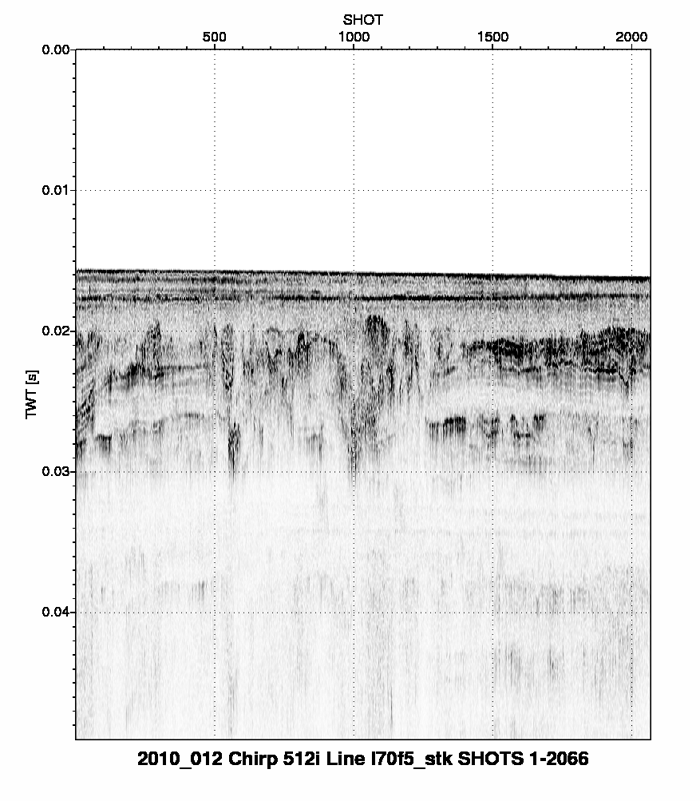
A script was run that used Seismic Unix (version 4.1) to read the SEG-Y files and plot the data as 8-bit gray scale Postscript files using the Seismic Unix 'psimage' algorithm. All images were created with a horizontal scale of 200 traces per inch. Images were plotted within a constant 12-inch vertical window of 50 milliseconds (Two-Way Travel Time) duration. The Postscript images were then converted to PNG format using ImageMagick (version 5.5.6).
Process_Date: 201009
Process_Contact:
Contact_Information:
Contact_Person_Primary:
Contact_Person: Elizabeth Pendleton
Contact_Organization: U.S. Geological Survey
Contact_Position: Geologist
Contact_Address:
Address_Type: mailing and physical address
Address: 384 Woods Hole Rd.
City: Woods Hole
State_or_Province: MA
Postal_Code: 02543-1598
Contact_Voice_Telephone: (508) 548-8700x2259
Contact_Facsimile_Telephone: (508) 457-2310
Contact_Electronic_Mail_Address: ependleton@usgs.gov
Process_Step:
Process_Description:
Edits to the metadata were made to fix any errors that MP v 2.9.36 flagged. This is necessary to enable the metadata to be successfully harvested for various data catalogs. In some cases, this meant adding text "Information unavailable" or "Information unavailable from original metadata" for those required fields that were left blank. Other minor edits were probably performed (title, publisher, publication place, etc.). The link to the data in the Identification_Information section had to be fixed. Attempted to modify http to https where appropriate. Added a landing page link as the first link in the identification section. The link to the data in the Distribution_Information section had to be fixed. Fixed the link to the browse graphic. Updated the link to the field activity. The source information was incomplete and had to be modified to meet the standard. The distribution format name was modified in an attempt to be more consistent with other metadata files of the same data format. Updated a link to a cross-reference. The metadata date (but not the metadata creator) was edited to reflect the date of these changes. The metadata available from a harvester may supersede metadata bundled within a download file. Compare the metadata dates to determine which metadata file is most recent.
Process_Date: 20171030
Process_Contact:
Contact_Information:
Contact_Organization_Primary:
Contact_Organization: U.S. Geological Survey
Contact_Person: VeeAnn A. Cross
Contact_Position: Marine Geologist
Contact_Address:
Address_Type: Mailing and Physical
Address: 384 Woods Hole Road
City: Woods Hole
State_or_Province: MA
Postal_Code: 02543-1598
Contact_Voice_Telephone: 508-548-8700 x2251
Contact_Facsimile_Telephone: 508-457-2310
Contact_Electronic_Mail_Address: vatnipp@usgs.gov
Process_Step:
Process_Description:
Keywords section of metadata optimized for discovery in USGS Coastal and Marine Geology Data Catalog.
Process_Date: 20171203
Process_Contact:
Contact_Information:
Contact_Organization_Primary:
Contact_Organization: U.S. Geological Survey
Contact_Person: Alan O. Allwardt
Contact_Position: Contractor -- Information Specialist
Contact_Address:
Address_Type: Mailing and Physical
Address: 2885 Mission Street
City: Santa Cruz
State_or_Province: CA
Postal_Code: 95060
Contact_Voice_Telephone: 831-460-7551
Contact_Facsimile_Telephone: 831-427-4748
Contact_Electronic_Mail_Address: aallwardt@usgs.gov
Process_Step:
Process_Description:
This metadata record was modified from one describing PNG images to reflect the SEG-Y version of the same data (Open-File Report 2010-1178, https://pubs.usgs.gov/of/2010/1178/). Changes were made to the Citation and Distribution_Information.
Process_Date: 20171204
Process_Contact:
Contact_Information:
Contact_Organization_Primary:
Contact_Organization: U.S. Geological Survey
Contact_Person: VeeAnn A. Cross
Contact_Position: Marine Geologist
Contact_Address:
Address_Type: Mailing and Physical
Address: 384 Woods Hole Road
City: Woods Hole
State_or_Province: MA
Postal_Code: 02543-1598
Contact_Voice_Telephone: 508-548-8700 x2251
Contact_Facsimile_Telephone: 508-457-2310
Contact_Electronic_Mail_Address: vatnipp@usgs.gov
Process_Step:
Process_Description:
Added keywords section with USGS persistent identifier as theme keyword.
Process_Date: 20200908
Process_Contact:
Contact_Information:
Contact_Organization_Primary:
Contact_Organization: U.S. Geological Survey
Contact_Person: VeeAnn A. Cross
Contact_Position: Marine Geologist
Contact_Address:
Address_Type: Mailing and Physical
Address: 384 Woods Hole Road
City: Woods Hole
State_or_Province: MA
Postal_Code: 02543-1598
Contact_Voice_Telephone: 508-548-8700 x2251
Contact_Facsimile_Telephone: 508-457-2310
Contact_Electronic_Mail_Address: vatnipp@usgs.gov
Spatial_Data_Organization_Information:
Direct_Spatial_Reference_Method: Raster
Raster_Object_Information:
Raster_Object_Type: pixel
Distribution_Information:
Distributor:
Contact_Information:
Contact_Person_Primary:
Contact_Person: Elizabeth Pendleton
Contact_Organization: U.S. Geological Survey
Contact_Position: Geologist
Contact_Address:
Address_Type: mailing and physical address
Address: 384 Woods Hole Rd.
City: Woods Hole
State_or_Province: MA
Postal_Code: 02543-1598
Contact_Voice_Telephone: (508) 548-8700x2259
Contact_Facsimile_Telephone: (508) 457-2310
Contact_Electronic_Mail_Address: ependleton@usgs.gov
Resource_Description: Downloadable Data
Distribution_Liability:
Neither the U.S. Government, the Department of the Interior, nor the USGS, nor any of their employees, contractors, or subcontractors, make any warranty, express or implied, nor assume any legal liability or responsibility for the accuracy, completeness, or usefulness of any information, apparatus, product, or process disclosed, nor represent that its use would not infringe on privately owned rights. The act of distribution shall not constitute any such warranty, and no responsibility is assumed by the USGS in the use of these data or related materials. Any use of trade, product, or firm names is for descriptive purposes only and does not imply endorsement by the U.S. Government.
Standard_Order_Process:
Digital_Form:
Digital_Transfer_Information:
Format_Name: SEG-Y
Format_Information_Content: Link is to a folder containing SEG-Y files.
Digital_Transfer_Option:
Online_Option:
Computer_Contact_Information:
Network_Address:
Access_Instructions:
Data can be downloaded via the World Wide Web (WWW). The online link gives access to the folder containing the individual SEG-Y files.
Fees: none
Technical_Prerequisites: These data require software that can read SEG-Y data.
Metadata_Reference_Information:
Metadata_Date: 20200908
Metadata_Contact:
Contact_Information:
Contact_Person_Primary:
Contact_Person: Elizabeth Pendleton
Contact_Organization: U.S. Geological Survey
Contact_Position: Geologist
Contact_Address:
Address_Type: mailing and physical address
Address: 384 Woods Hole Rd.
City: Woods Hole
State_or_Province: MA
Postal_Code: 02543-1598
Contact_Voice_Telephone: (508) 548-8700x2259
Contact_Facsimile_Telephone: (508) 457-2310
Contact_Electronic_Mail_Address: ependleton@usgs.gov
Metadata_Standard_Name: FGDC Content Standards for Digital Geospatial Metadata
Metadata_Standard_Version: FGDC-STD-001-1998
Metadata_Time_Convention: local time
Metadata_Access_Constraints: None
Metadata_Use_Constraints: None

This page is <https://cmgds.marine.usgs.gov/catalog/whcmsc/segy/2010-012-FA_segy.html>
Generated by mp version 2.9.50 on Tue Sep 21 18:20:42 2021