Chirp seismic reflection and navigation data collected in Chesapeake Bay during USGS Field Activity 2022-020-FA
By David S Foster, Wayne E Baldwin, John Pohlman, and Laura L. Lapham
https://doi.org/10.5066/P13DCCU3
Dates
Published: April 28, 2025
Data Collected: July 25, 2022 – July 29, 2022
Summary
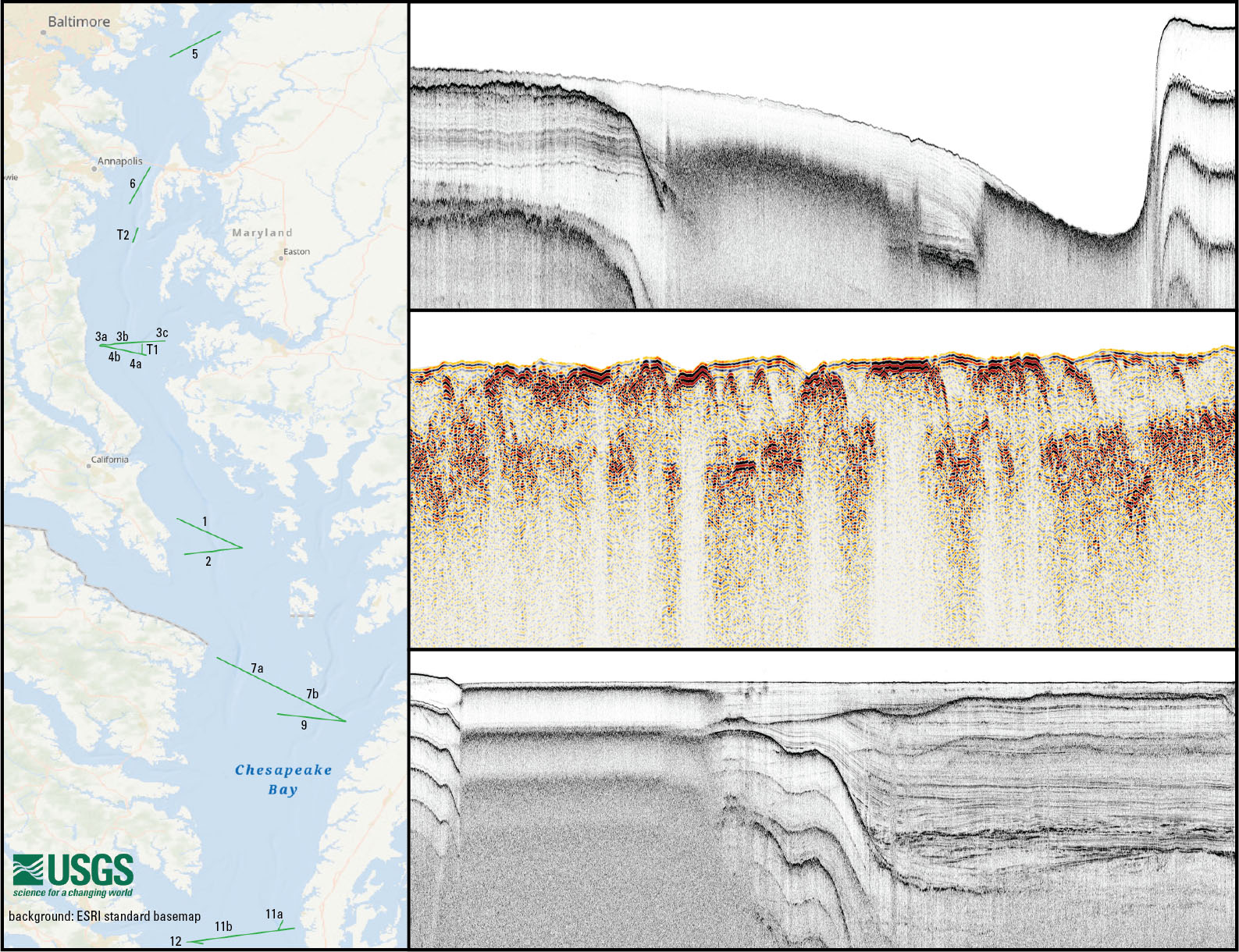
In July 2022, the U.S. Geological Survey (USGS) and the University of Maryland’s Chesapeake Biological Laboratory conducted a study, USGS Field Activity Number (FAN) 2022-020-FA, in Chesapeake Bay to quantify greenhouse gas fluxes from the largest estuary in the United States. The team investigated the environmental factors that control the distribution and exchange of methane and carbon dioxide in the sediments, water column, and fluxes across the atmospheric boundary layer(sea-air interface) during the annual summer occurrence of widespread anoxia that threatens the health of the bay. As part of this study, chirp seismic-reflection profiles were collected along a series of transects to characterize the sediments, stratigraphy, and acoustic signatures of gas in the sediments.
Seismic Data
-
Chirp seismic reflection and navigation data collected in Chesapeake Bay during USGS Field Activity 2022-020-FA
This dataset contains shotpoint and trackline navigation, profile images, and processed SEG-Y (Norris and Faichney, 2002) trace data for approximately 156.7 km of EdgeTech 3400 chirp seismic-reflection data collected by the USGS during USGS FAN 2022-020-FA in Chesapeake Bay. Images of each seismic profile were generated to provide portable and easily viewable alternatives to the SEG-Y versions of the data. Each profile image can be associated with its corresponding trackline navigation contained within the Esri polyline shapefile '2022-020-FA_ET3400_Tracklines.shp'. Shotpoint index and tick marks along the top of the Portable Network Graphics (PNG) images correlate to the positions of 500 shot intervals within the Esri point shapefile '2022-020-FA_ET3400_sht500.shp'. This information allows for spatial correlation of chirp seismic-reflection profiles images with other geophysical and sample data for investigating sea-floor morphology and stratigraphy in the area.
Data Files
2022-020-FA_ET3400_Images.zip - 346.0 MB
2022-020-FA_ET3400_SegyData.zip - 8.5 GB
2022-020-FA_ET3400_Shapefiles.zip - 1.8 MB
2022-020-FA_ET3400_shotnav.zip - 3.8 MB
Metadata Files
2022-020-FA_ET3400_meta.xml - 43.4 KB
2022-020-FA_ET3400_meta.txt - 43.1 KB

Suggested Citation
Foster, D.S., Baldwin, W.E., Pohlman, J.W., and Lapham, L.L., 2025, Chirp seismic reflection and navigation data collected in Chesapeake Bay during USGS Field Activity 2022-020-FA: U.S. Geological Survey data release, https://doi.org/10.5066/P13DCCU3.
Overview Image