Detailed Aeromagnetic Survey of the Trinidad Area, California
By Janet T. Watt, Victoria E Langenheim, and Lydia M Staisch
https://doi.org/10.5066/P13SZBH7
Dates
Published: April 3, 2025
Data Collected: Aug. 28, 2024 – Sept. 27, 2024
Summary
This data release provides access to a low-altitude, aeromagnetic survey of a part of northwestern California. These data were acquired to support earthquake and tsunami hazard investigations and geologic mapping of the greater Trinidad area of northwestern California. Magnetic data are provided as a database and the residual magnetic intensity is provided as a grid.
Magnetic Data
-
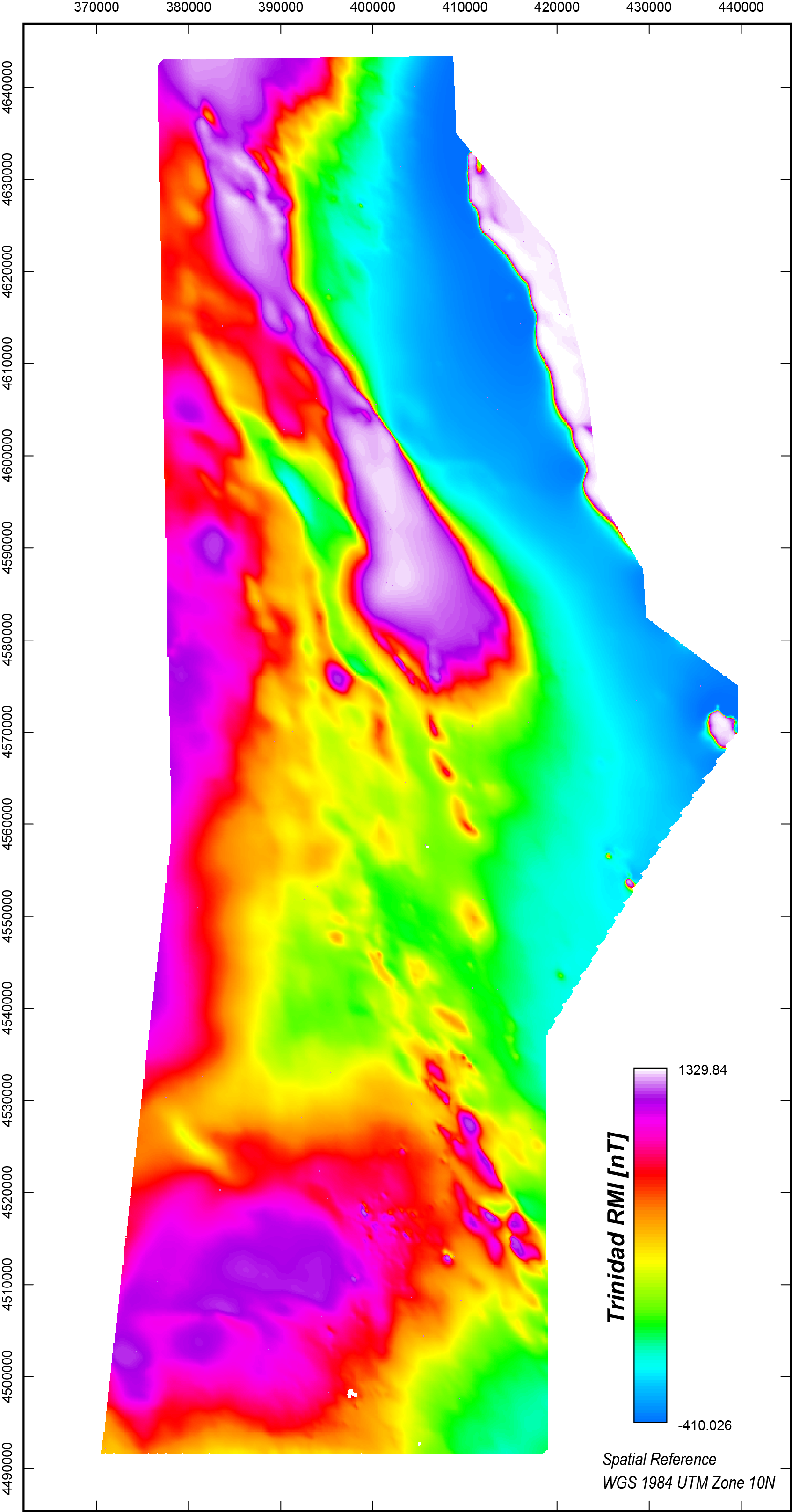
Detailed aeromagnetic survey grid of the Trinidad Area, California
This data release provides access to gridded data from a low-altitude, aeromagnetic survey of a part of northwestern California. The survey extends west of the Klamath Mountains across the Pacific Ocean coastline over the continental shelf and covers the towns of Crescent City, Trinidad, Fortuna, Eureka, Arcata, and McKinleyville. Data were acquired during the summer and fall of 2024 by Xcalibur Multiphysics working under contract to the Yurok Tribe and under supervision of the U.S. Geological Survey. Total magnetic field values were acquired using a fixed-wing aircraft flown at a target elevation of 305 meters (m) above terrain and along flight lines and tie lines spaced 600 m and 6000 m apart, respectively. Flight lines were directed northeast-southwest; tie lines were directed northwest-southeast. A total of 13,134 line-kilometers were acquired.
Data Files
Trinidad_RMI_Final.zip - 2.5 MB
Metadata Files
Trinidad_RMI_Final_metadata.xml - 22.7 KB
Trinidad_RMI_Final_metadata.txt - 21.9 KB
-
Detailed aeromagnetic survey point data of the Trinidad Area, California
This data release provides access to point measurement data from a low-altitude, aeromagnetic survey of a part of northwestern California. The survey extends west of the Klamath Mountains across the Pacific Ocean coastline over the continental shelf and covers the towns of Crescent City, Trinidad, Fortuna, Eureka, Arcata, and McKinleyville. Data were acquired during the summer and fall of 2024 by Xcalibur Multiphysics working under contract to the Yurok Tribe and under supervision of the U.S. Geological Survey. Total magnetic field values were acquired using a fixed-wing aircraft flown at a target elevation of 305 meters (m) above terrain and along flight lines and tie lines spaced 600 m and 6000 m apart, respectively. Flight lines were directed northeast-southwest; tie lines were directed northwest-southeast. A total of 13,134 line-kilometers were acquired.
Data Files
Trinidad_aeromag.csv - 856.1 MB
Metadata Files
Trinidad_aeromag_metadata.xml - 27.5 KB
Trinidad_aeromag_metadata.txt - 26.5 KB
Support Files
Suggested Citation
Watt, J.T., Langenheim, V.E., Staisch, L.M., 2025, Detailed aeromagnetic survey of the Trinidad area, California: U.S. Geological Survey data release, https://doi.org/10.5066/P13SZBH7
Overview Image