Composite multibeam bathymetry surface of the northern Cascadia Margin offshore Washington
By Jeffrey Beeson, Peter Dartnell, and Janet T. Watt
https://doi.org/10.5066/P14SLWTD
Dates
Published: April 23, 2025
Summary
Composite 30-m resolution bathymetric surface of northern Cascadia Margin offshore Washington. The surface was generated from various publicly available bathymetric datasets available in the region. The surface is available as a geoTIFF file.
Location-Elevation Data
-
Composite bathymetric surface of the northern Cascadia Margin offshore Washington
Composite 30-m resolution bathymetric surface of northern Cascadia Margin offshore Washington. The bathymetric surface is available as a GeoTIFF file.
Data Files
NorthernCascadia_composite_bathymetry_UTM10_NAD83.zip - 117.0 MB - MD5:8cf95186b7a02c2ff120cce9403d7ded
Metadata Files
NorthernCascadia_composite_bathymetry_UTM10_NAD83_metadata.xml - 19.8 KB
NorthernCascadia_composite_bathymetry_UTM10_NAD83_metadata.txt - 19.6 KB
Support Files
NorthernCascadia composite_bathymetry_data_sources.csv - 4.4 KB
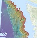 Preview image of the northern Cascadia Margin composite bathymetry

Suggested Citation
Beeson, J.W., Dartnell, P., Watt, J.T., 2025, Composite bathymetric surface of the northern Cascadia Margin offshore Washington: U.S. Geological Survey data release, https://doi.org/10.5066/P14SLWTD.