Digital seafloor images, sediment grain size, bathymetry, and water velocity data from the lower Columbia River, Oregon and Washington, 2021
By Andrew W. Stevens, Gerry A. Hatcher, Peter Dal Ferro, Peter Dartnell, Jonathan A. Warrick, Nicholas Cohn, and Hans R. Moritz
https://doi.org/10.5066/P92U1KPY
Dates
Published: Aug. 8, 2023
Data Collected: June 5, 2021 – June 9, 2021
Summary
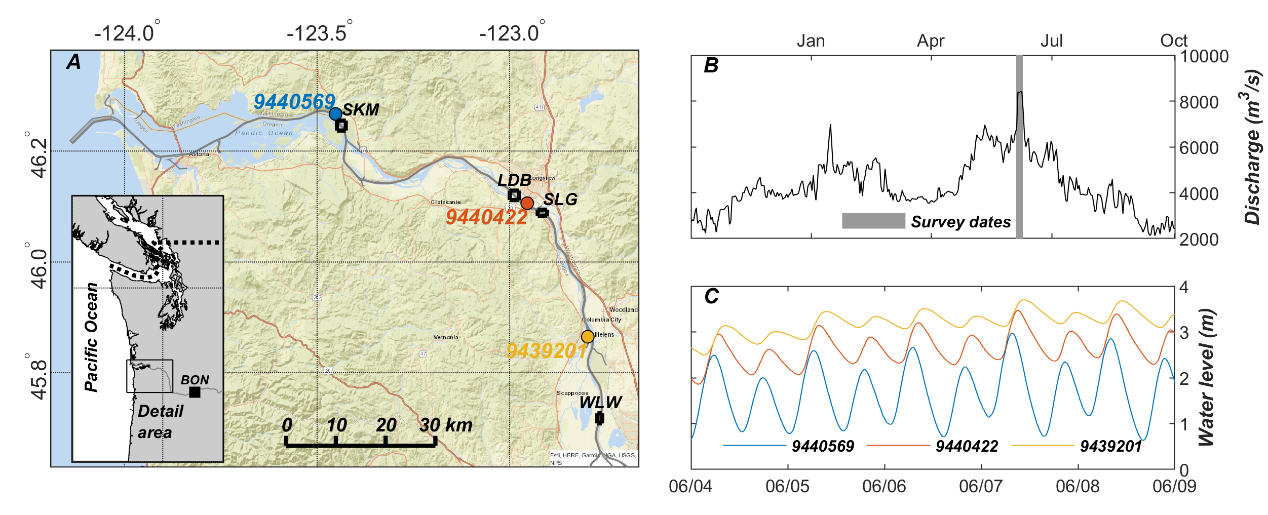
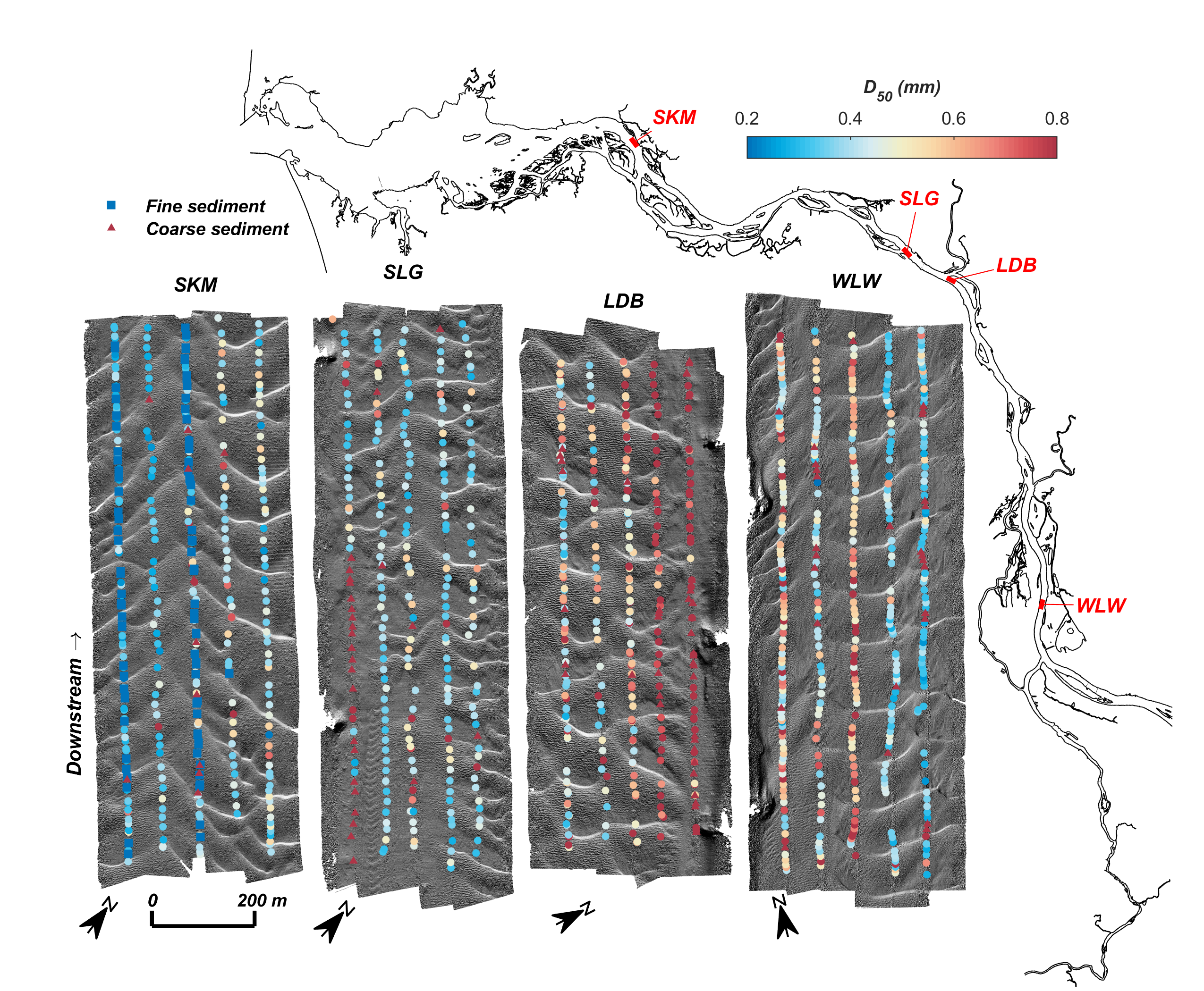
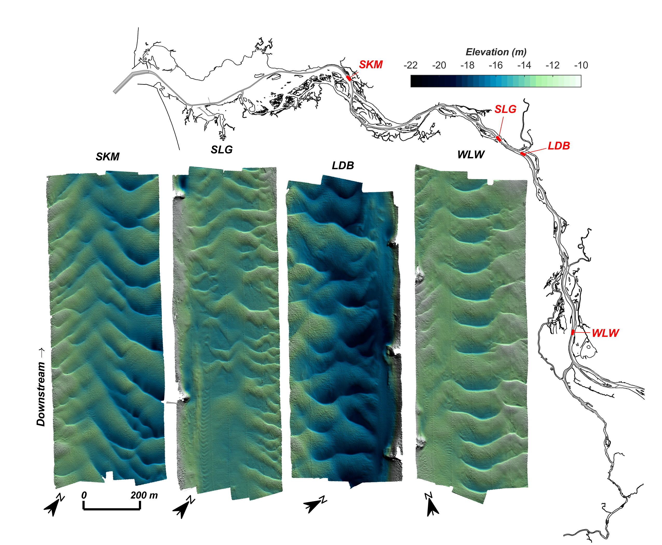
Growth of subaqueous sand dunes commonly causes shoaling in engineered river channels that necessitates costly dredging to maintain adequate depths for navigation. The factors that result in sand wave growth are theoretically understood from laboratory experiments, but the capacity to predict sand wave geometries in field settings is limited due to temporal and spatial variability in hydrodynamics and sediment grain size. Detailed measurements of sand wave geometries, hydrodynamics, and grain size are therefore needed to test and improve numerical models and inform efficient management strategies in navigation channels. This data release presents surface sediment grain size distributions, bathymetry and seafloor acoustic backscatter, and water velocity data acquired at four sites with subaqueous sand dunes in the lower Columbia River, Washington and Oregon, between June 5 and June 9, 2021. The four sites (SKM, SLG, LDB, and WLW) were located between 65 km and 127 km upstream from the ocean inlet along a gradient of relative tidal and fluvial influence. The survey was performed during peak annual river discharge when sediment transport processes were likely active. Between 248 and 427 digital images were collected at each site with an underwater camera system that was repeatedly lowered to the seabed along a series of 1 km-long transects oriented along the main navigation channel and spaced about 60 m apart. The grain size distributions of the seabed images were estimated using an automated image processing technique and tested with observed grain size distributions derived from manual measurements on a subset of 16 images. Swath bathymetry and seafloor acoustic backscatter data were collected repeatedly at each site using a 234.5 kHz phase-differencing sidescan sonar to characterize sand wave geometry and bathymetric change resulting from sand wave migration. Current velocity data were collected from an underway survey vessel equipped with a downward looking 600 kHz ADCP along transects oriented both along- and across the main navigation channel. Combined, these data provide a comprehensive characterization of mobile subaqueous sand dunes that can be used to improve predictions of dune growth in complicated field settings and inform efficient sediment management practices in the lower Columbia River.
Sediment Properties Data
-
In situ seafloor images from the lower Columbia River, Washington and Oregon, 2021
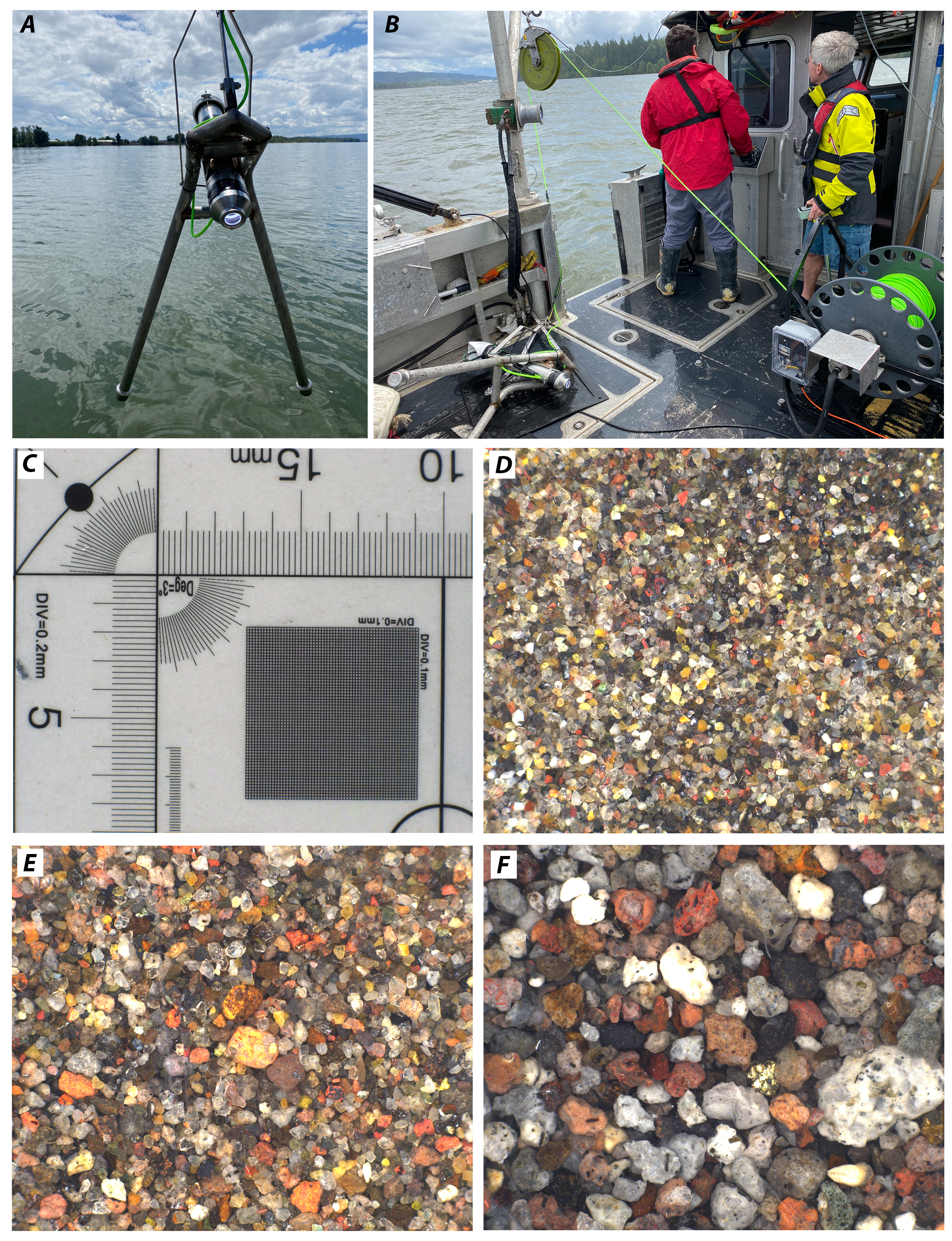
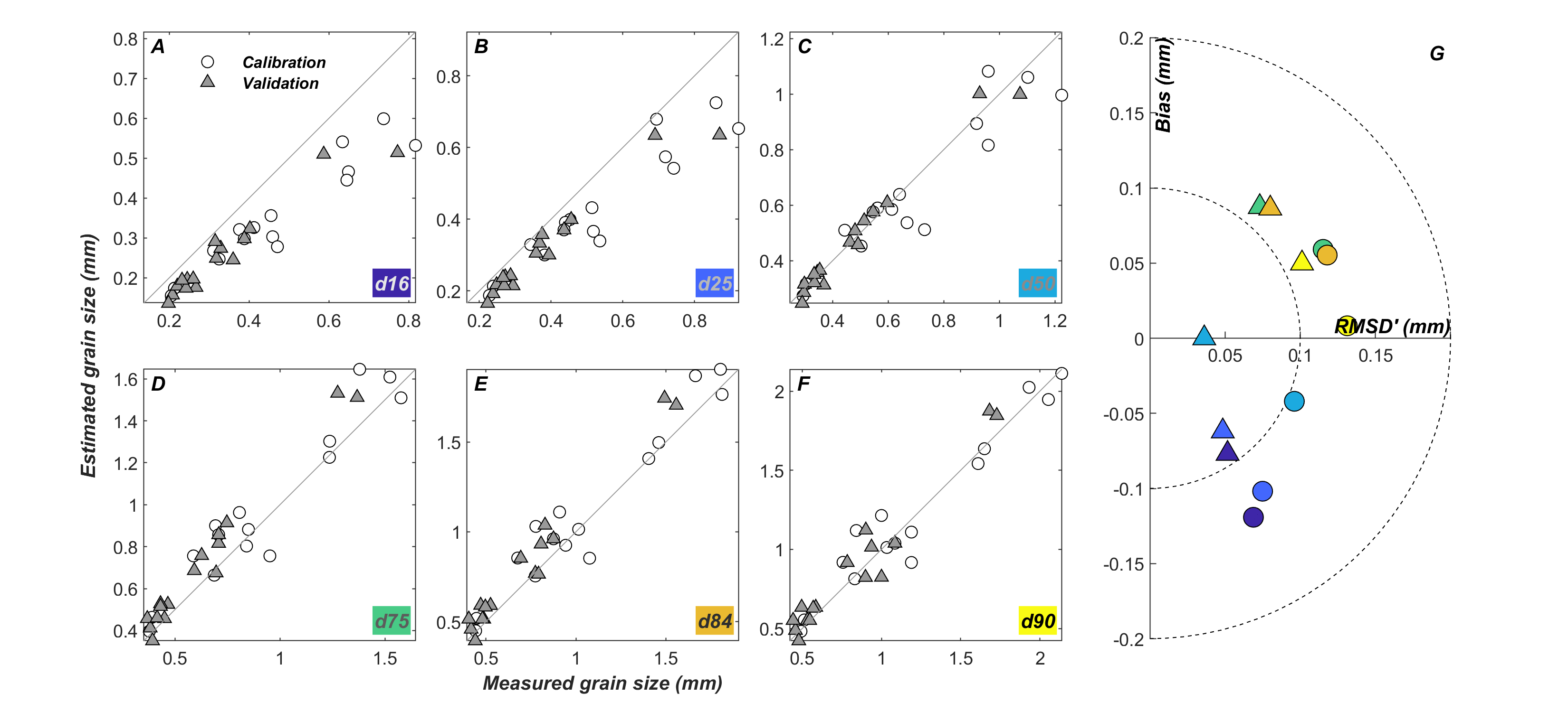
In situ seafloor images were acquired at four sites (SKM, SLG, LDB, WLW) in the lower Columbia River, Washington and Oregon, with an underwater camera system between June 5 and June 8, 2021. Between 248 and 427 digital images of the sediment surface were collected at each site with an underwater camera system that was repeatedly lowered to the seabed along a series of 1 km-long transects oriented along the main navigation channel and spaced about 60 m apart. The camera consisted of a FLIR Blackfly BFS-PGE-50S5 camera and 50 mm lens in a waterproof housing that resulted in a field of view of approximately 17 mm and a resolution of 0.00657 mm per pixel when the housing window was flush with the sediment surface. The imagery is provided in .tif format and compressed into .zip archives for each site. Images used for calibration of the automated processing algorithm to determine sediment grain size distributions were different than those used to validate the technique and were provided in separate .zip archives.
Data Files
dgs_images_calibration.zip - 198.3 MB
dgs_images_ldb.zip - 4.4 GB
dgs_images_skm.zip - 4.6 GB
dgs_images_slg.zip - 3.2 GB
dgs_images_validation.zip - 199.0 MB
dgs_images_wlw.zip - 5.4 GB
Metadata Files
dgs_images_metadata.xml - 21.0 KB
dgs_images_metadata.txt - 20.3 KB

-
Surface sediment grain size distributions derived from automated image processing of in situ seafloor images from the lower Columbia River, Washington and Oregon, 2021
This dataset contains surface sediment grain size distributions derived from automated image processing of in situ seafloor images obtained with an underwater camera system at four sites (SKM, SLG, LDB, WLW) in the lower Columbia River, Washington and Oregon, in 2021. The surface sediment grain size distribution data are provided in comma-separated text (.csv) format for each site and for data used in calibration and validation of the automated image processing technique.
Data Files
dgs_calibration_validation.csv - 12.5 KB
dgs_ldb.csv - 126.0 KB
dgs_skm.csv - 131.2 KB
dgs_slg.csv - 92.5 KB
dgs_wlw.csv - 157.2 KB
Metadata Files
dgs_metadata.xml - 54.6 KB
dgs_metadata.txt - 53.8 KB
-
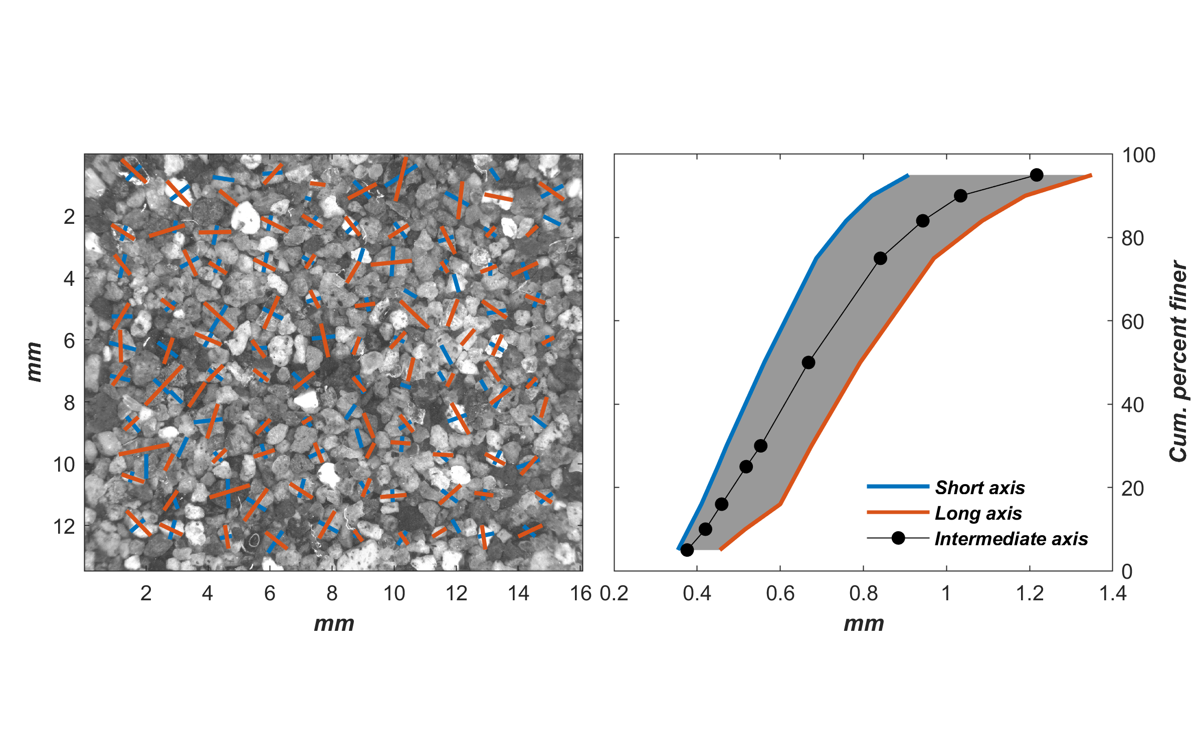
Surface sediment grain size distributions derived from manual point counts of in situ seafloor images from the lower Columbia River, Washington and Oregon, 2021
This dataset contains surface sediment grain size distributions derived from manual point counts of in situ seafloor images obtained with an underwater camera system in the lower Columbia River, Washington and Oregon, in 2021. The distributions derived from manual point counts were compared with results from an automated image processing technique to calibrate and validate the automated method used to quantify surface sediment grain size distributions in objective images. The surface sediment grain size distribution data derived from manual point counts are provided in comma-separated text format (point_count_distributions.csv) and should be compared with grain size distributions for the same set of images (dgs_calibration_validation.csv) derived from automated image processing that can be found in the "Surface sediment grain size distributions derived from automated image processing of in situ seafloor images from the lower Columbia River, Washington and Oregon, 2021" portion of the overall data release.
Data Files
point_count_distributions.csv - 12.0 KB
Metadata Files
point_count_distributions_metadata.xml - 39.8 KB
point_count_distributions_metadata.txt - 39.1 KB

-
Surface sediment grain diameter measurements from point counts of in situ seafloor images collected in the lower Columbia River, Washington and Oregon, 2021
This dataset contains surface sediment grain diameter measurements from in situ seafloor images collected in the lower Columbia River, Washington and Oregon, in 2021. Surface sediment grain diameters were derived from manual measurements (or "point counts") in a subset of images used to calibrate and validate an automated image processing algorithm to determine surface sediment grain size distributions. For each calibration and validation image that was selected, the long and short axis of 100 grains were manually measured. The grain diameter measurements are provided in comma-separated (.csv) format and compressed into separate .zip archives for images used for calibration and validation of the automated image processing technique.
Data Files
point_counts_calibration.zip - 48.5 KB
point_counts_validation.zip - 51.2 KB
Metadata Files
Depth Data
-
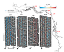
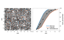
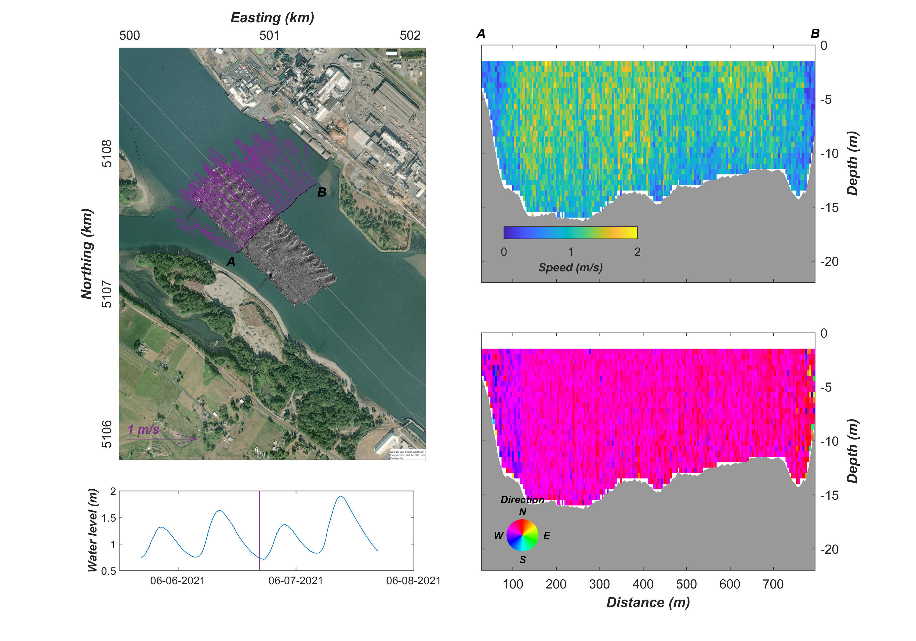
Bathymetry and seafloor acoustic backscatter of mobile subaqueous sand dunes in the lower Columbia River, Washington and Oregon, 2021
Bathymetry and seafloor acoustic backscatter data were collected at four sites (SKM, SLG, LDB, WLW) using a SWATHPlus interferometric sonar (234 kHz) pole mounted to the R/V Parke Snavely during a June 2021 survey of the lower Columbia River, Washington and Oregon. Each site was surveyed repeatedly between June 5 and June 9, 2021 to quantify bathymetric changes resulting from migration of subaqueous sand dunes. The bathymetry and seafloor acoustic backscatter data from each site are provided as GeoTIFF images.
Data Files
lcr21_backscatter.zip - 10.5 MB
lcr21_bathy.zip - 43.4 MB
Metadata Files
lcr21_bathy_backscatter_metadata.xml - 19.8 KB
lcr21_bathy_backscatter_metadata.txt - 19.4 KB
Support Files
swath_survey_dates_times.csv - 1.1 KB

Current Data
-
Vessel-mounted acoustic Doppler current profiler (ADCP) data from the lower Columbia River, Washington and Oregon, 2021
This dataset contains water velocity data derived from spatial surveys performed with a vessel-mounted acoustic Doppler current profiler at four sites (SKM, SLG, LDB, WLW) in the lower Columbia River, Washington and Oregon, in 2021. The data are provided in netCDF (.nc) format and compressed into .zip archives for each site.
Data Files
ldb_vmadcp.zip - 723.5 KB
skm_vmadcp.zip - 471.0 KB
slg_vmadcp.zip - 585.8 KB
wlw_vmadcp.zip - 379.8 KB
Metadata Files
vmadcp_metadata.xml - 17.3 KB
vmadcp_metadata.txt - 16.7 KB
Support Files
vmadcp_file_list.csv - 1.6 KB
Related Field Activities
- 2021-621-FA - View Details
Suggested Citation
Stevens, A.W., Hatcher, G.A., Dal Ferro, P., Dartnell, P., Warrick, J.A., Cohn, N., and Moritz, H.R., 2023, Digital seafloor images, sediment grain size, bathymetry and water velocity data from the lower Columbia River, Washington and Oregon, 2021: U.S. Geological Survey data release, https://doi.org/10.5066/P92U1KPY.
Overview Image