Donated ROV vibracore and sampling data collected during Monterey Bay Aquarium Research Institute cruises in 2019 offshore of south-central California
By Daniel J. Kennedy, Maureen A. Walton, Guy R. Cochrane, Charlie K. Paull, Roberto Gwiazda, Eve M. Lundsten, Linda A. Kuhnz, Thomas D. Lorenson, Mary L. McGann, Nora M. Nieminski, and Jason A. Addison
https://doi.org/10.5066/P9E2OP35
Dates
Published: Oct. 16, 2021
Data Collected: Feb. 4, 2019 – Nov. 10, 2019
Summary
This dataset includes photographs of vibracores that were collected by the Monterey Bay Aquarium Research Institute (MBARI) in February 2019 and November 2019 aboard the R/V Western Flyer using the remotely operated vehicle (ROV) Doc Ricketts. The collection of these cores was funded entirely by MBARI, and the cores have been donated to the U.S. Geological Survey (USGS). The cores were collected in collaboration with the USGS and the Bureau of Ocean Energy Management (BOEM) and are located in the same study area as the collaborative California Deepwater Investigations and Groundtruthing (Cal DIG I) project. The purpose of the overall Cal DIG I study is to assess shallow geohazards, benthic habitats, and thereby the potential for alternative energy infrastructure (namely floating wind turbines) offshore south-central California due to the study area's proximity to power grid infrastructure associated with the Morro Bay power plant. These data provide information about the geology of the seafloor and shallow subsurface offshore of the south-central California coast.
Sampling Data
-
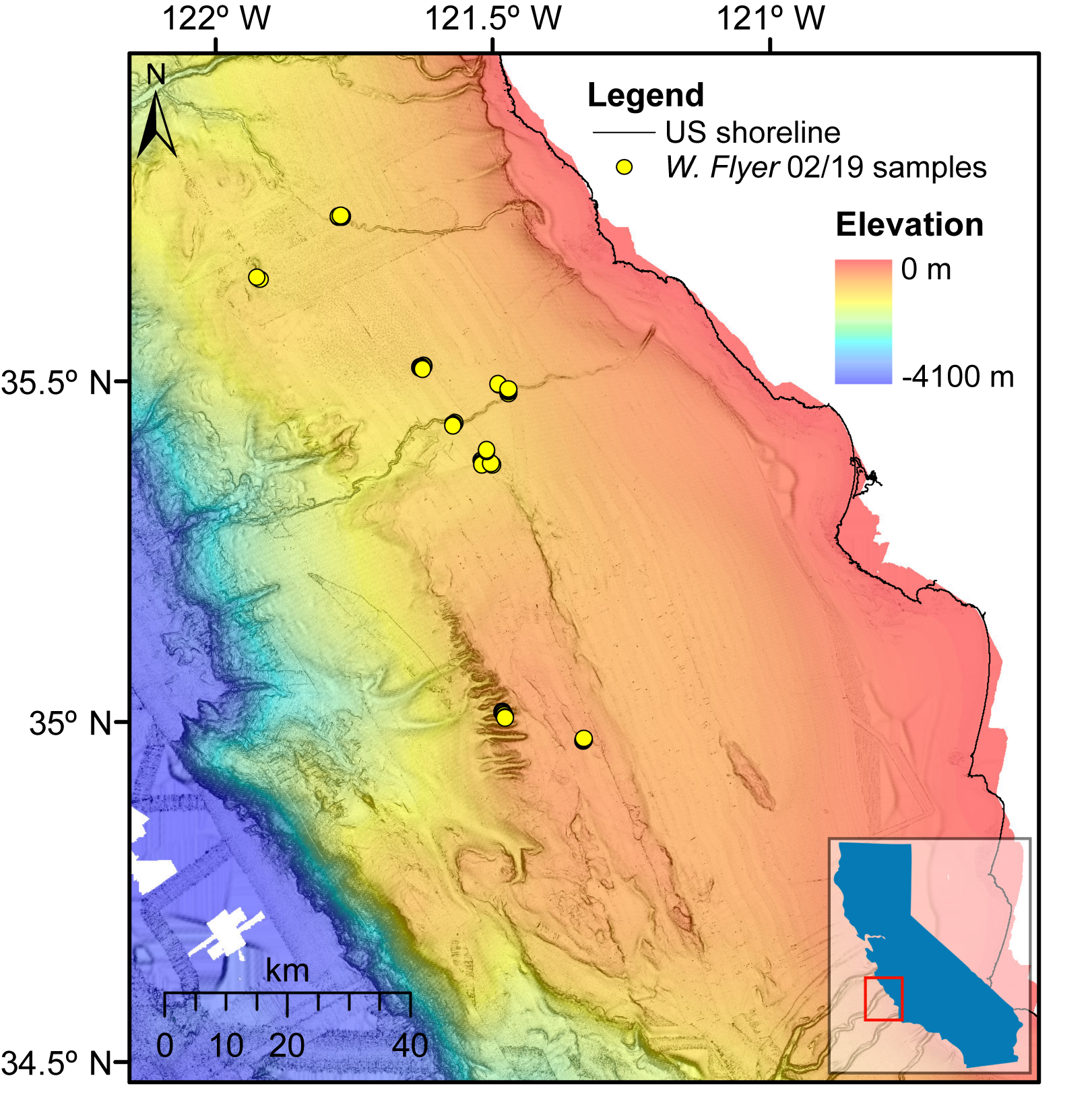
Location and depth data for vibracores collected during a Monterey Bay Aquarium Research Institute cruise in February 2019 offshore of south-central California (USGS FAN 2019-603-FA)
This dataset includes the location and depth information for 49 vibracores that were collected by the Monterey Bay Aquarium Research Institute (MBARI) in February 2019 aboard the R/V Western Flyer using the remotely operated vehicle (ROV) Doc Ricketts. The collection of these cores was funded entirely by MBARI, and the cores have been donated to the U.S. Geological Survey (USGS). The cores were collected in collaboration with the USGS and the Bureau of Ocean Energy Management (BOEM) and are located in the same study area as the collaborative California Deepwater Investigations and Groundtruthing (Cal DIG I) project. The purpose of the overall Cal DIG I study is to assess shallow geohazards, benthic habitats, and thereby the potential for alternative energy infrastructure (namely floating wind turbines) offshore south-central California due to the study area's proximity to power grid infrastructure associated with the Morro Bay power plant. These data provide information about the geology of the seafloor and shallow subsurface offshore of the south-central California coast.
Data Files
2019-603-FA_Feb2019vibracore_locations_depth.csv - 3.2 KB - MD5:bdd644f376a80b1272513f39491b2107
Metadata Files
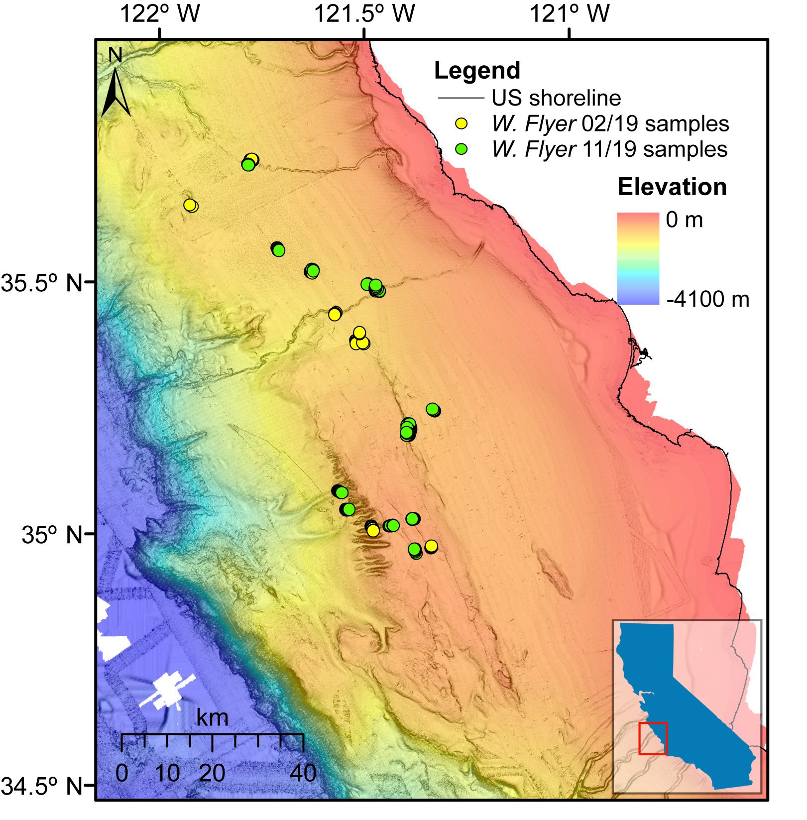
 Colored shaded-relief map of south-central California showing locations of vibracores collected in February 2019 in yellow.
 -
Location data for vibracores collected during a Monterey Bay Aquarium Research Institute cruise in November 2019 offshore of south-central California (USGS FAN 2019-667-FA)
This dataset includes the location information for 49 vibracores that were collected by the Monterey Bay Aquarium Research Institute (MBARI) in November 2019 aboard the R/V Western Flyer using the remotely operated vehicle (ROV) Doc Ricketts. The collection of these cores was funded entirely by MBARI, and the cores have been donated to the U.S. Geological Survey (USGS). The cores were collected in collaboration with the USGS and the Bureau of Ocean Energy Management (BOEM) and are located in the same study area as the collaborative California Deepwater Investigations and Groundtruthing (Cal DIG I) project. The purpose of the overall Cal DIG I study is to assess shallow geohazards, benthic habitats, and thereby the potential for alternative energy infrastructure (namely floating wind turbines) offshore south-central California due to the study area's proximity to power grid infrastructure associated with the Morro Bay power plant. These data provide information about the geology of the seafloor and shallow subsurface offshore of the south-central California coast.
Data Files
2019-667-FA_Nov2019vibracore_locations.csv - 2.6 KB - MD5:8abda246a293051011b7474ff58a4277
Metadata Files
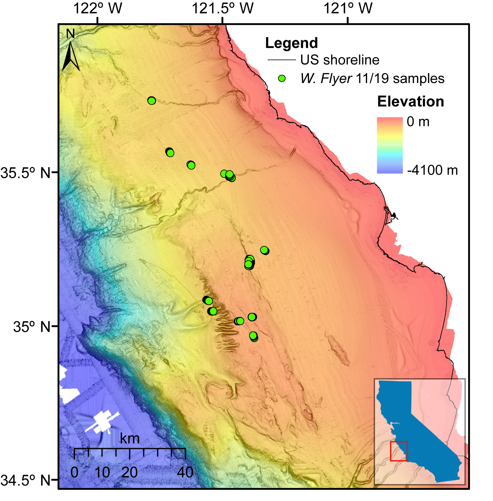
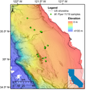 Colored shaded-relief map of south-central California showing locations of vibracores collected in November 2019 in green.
 -
Photographs of vibracores collected during a Monterey Bay Aquarium Research Institute cruise in February 2019 offshore of south-central California (USGS FAN 2019-603-FA)
This dataset includes photographs of 49 vibracores that were collected by the Monterey Bay Aquarium Research Institute (MBARI) in February 2019 aboard the R/V Western Flyer using the remotely operated vehicle (ROV) Doc Ricketts. The collection of these cores was funded entirely by MBARI, and the cores have been donated to the U.S. Geological Survey (USGS). The cores were collected in collaboration with the USGS and the Bureau of Ocean Energy Management (BOEM) and are located in the same study area as the collaborative California Deepwater Investigations and Groundtruthing (Cal DIG I) project. The purpose of the overall Cal DIG I study is to assess shallow geohazards, benthic habitats, and thereby the potential for alternative energy infrastructure (namely floating wind turbines) offshore south-central California due to the study area's proximity to power grid infrastructure associated with the Morro Bay power plant. These data provide information about the geology of the seafloor and shallow subsurface offshore of the south-central California coast.
Data Files
2019-603-FA_Feb2019vibracore.zip - 7.2 GB - MD5:f99c81607300f33b5e2f104b02be2057
Metadata Files
 Colored shaded-relief map of south-central California showing locations of vibracores collected in February 2019 in yellow.
 -
Photographs of vibracores collected during a Monterey Bay Aquarium Research Institute cruise in November 2019 offshore of south-central California (USGS FAN 2019-667-FA)
This dataset includes photographs of 49 vibracores that were collected by the Monterey Bay Aquarium Research Institute (MBARI) in November 2019 aboard the R/V Western Flyer using the remotely operated vehicle (ROV) Doc Ricketts. The collection of these cores was funded entirely by MBARI, and the cores have been donated to the U.S. Geological Survey (USGS). The cores were collected in collaboration with the USGS and the Bureau of Ocean Energy Management (BOEM) and are located in the same study area as the collaborative California Deepwater Investigations and Groundtruthing (Cal DIG I) project. The purpose of the overall Cal DIG I study is to assess shallow geohazards, benthic habitats, and thereby the potential for alternative energy infrastructure (namely floating wind turbines) offshore south-central California due to the study area's proximity to power grid infrastructure associated with the Morro Bay power plant. These data provide information about the geology of the seafloor and shallow subsurface offshore of the south-central California coast.
Data Files
2019-667-FA_Nov2019vibracore.zip - 23.7 GB - MD5:5fca6fa399689041b938c50948b263f1
Metadata Files
 Colored shaded-relief map of south-central California showing locations of vibracores collected in November 2019 in green.


Related Field Activities
- 2019-603-FA - View Details
- 2019-667-FA - View Details
Suggested Citation
Kennedy, D.J., Walton, M.A., Cochrane, G.R., Paul, C.K., Gwiazda, R., Lundsten, E., Kuhnz, L., Lorenson, T.D., McGann, M.L., Nieminski, N.M., and Addison, J.A., 2021, Donated ROV vibracore and sampling data collected during Monterey Bay Aquarium Research Institute cruises in 2019 offshore of south-central California: U.S. Geological Survey data release, https://doi.org/10.5066/P9E2OP35
Overview Image