Bathymetry, backscatter intensity, and benthic habitat offshore of Morro Bay, California (ver. 1.1, January 2024)
By Guy R. Cochrane, Aaron D. Cole, Meghan Sherrier, and Alia Roca-Lerza
https://doi.org/10.5066/P9HEZNRO
Dates
Published: April 3, 2022
Last Revised: Jan. 26, 2024 (ver. 1.1)
Summary
The surveys were conducted to map surficial geology and benthic habitat as part of the USGS California Seafloor Mapping Program, a collaboration with California State University Monterey Bay (CSUMB) and the National Oceanic and Atmospheric Administration (NOAA). These data are intended to provide regional bathymetric information in California State waters for offshore resource and ecosystem management. This data release is part of USGS Data Series 781 (Golden, 2019), which can be found at https://doi.org/10.3133/ds781.
Habitat Data
-
CMECS geoform, CMECS substrate, and surficial geology offshore of Morro Bay (ver. 1.1, January 2024)
This part of USGS Data Series 781 presents substrate, geomorphic, and geologic attributed polygons in the Offshore of Morro Bay, California, map area, one of 83 map areas of the California State Waters Map Series. The polygons are derived from multibeam echosounder (MBES) data and derivatives of that data using video-supervised and unsupervised classification. Attributes and attribute values are named following the Coastal and Marine Ecological Classification Standard (CMECS; Federal Geographic Data Committee, 2012) in order to be useful for ecosystems management.
Data Files
CMECS_OffshoreMorroBay.zip - 10.5 MB
Metadata Files
CMECS_OffshoreMorroBay_metadata.xml - 41.9 KB
CMECS_OffshoreMorroBay_metadata.txt - 45.2 KB
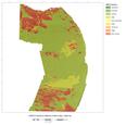 Classified CMECS geoforms data overlaid on shaded-relief bathymetry offshore of Morro Bay.
 -
Seafloor character offshore of Morro Bay, California
Seafloor character, a combination of seafloor induration (surface hardness) and rugosity, was derived from multibeam echosounder (MBES) and annotated underwater video data collected offshore of Morro Bay, California. The MBES and underwater video data were collected in support of the U.S. Geological Survey (USGS) California Seafloor Mapping Program, under a collaboration with the California State University Monterey Bay Seafloor Mapping Lab, the California Ocean Protection Council, and the National Oceanic and Atmospheric Administration (NOAA). Substrate observations from the underwater video were translated into Coastal and Marine Ecological Classification Standard (CMECS; Federal Geographic Data Committee, 2012) induration classes to use as training for a supervised numerical classification of the MBES data. The seafloor character raster is provided as a 2-meter resolution GeoTIFF.
Data Files
SeafloorCharacter_OffshoreMorroBay.zip - 1.1 MB
Metadata Files
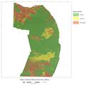 Classified seafloor character data overlaid on shaded-relief bathymetry offshore of Morro Bay.


Multibeam Data
-
Acoustic backscatter intensity from multibeam echosounder data collected offshore of Morro Bay, California
This part of USGS Data Series 781 (Golden, 2019) presents 2-m-resolution acoustic backscatter data for the Offshore of Morro Bay, California, map area. Backscatter data were collected by Fugro Pelagos in 2008 using a combination of 400-kHz Reson 7125, 240-kHz Reson 8101, and 100-kHz Reson 8111 multibeam echosounder systems. The data were post-processed by the California State University Monterey Bay Seafloor Mapping Lab and the University of California Santa Cruz Center for Integrated Spatial Research. The acoustic backscatter data are available as a georeferenced TIFF image. Within the final imagery, brighter tones indicate higher backscatter intensity, and darker tones indicate lower backscatter intensity. The intensity represents a complex interaction between the acoustic pulse and the seafloor, as well as characteristics within the shallow subsurface, providing a general indication of seafloor texture and composition. Backscatter intensity depends on the acoustic source level; the frequency used to image the seafloor; the grazing angle; the composition and character of the seafloor, including grain size, water content, bulk density, and seafloor roughness; and some biological cover. Harder and rougher bottom types such as rocky outcrops or coarse sediment typically return stronger intensities (high backscatter, lighter tones), whereas softer bottom types such as fine sediment return weaker intensities (low backscatter, darker tones).
Data Files
Backscatter_OffshoreMorroBay.zip - 24.8 MB
Metadata Files
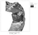 Quick view image of the acoustic-backscatter data in the offshore of Morro Bay study area.
 -
Bathymetry from multibeam echosounder data collected offshore of Morro Bay, California
This part of USGS Data Series 781 (Golden, 2019) presents 2-m-resolution bathymetry data for the Offshore of Morro Bay, California, map area. Bathymetry data were collected by Fugro Pelagos in 2008 using a combination of 400-kHz Reson 7125, 240-kHz Reson 8101, and 100-kHz Reson 8111 multibeam echosounder systems. The data were post-processed by the California State University Monterey Bay Seafloor Mapping Lab and the University of California Santa Cruz Center for Integrated Spatial Research. The bathymetry data are available as a georeferenced TIFF image.
Data Files
Bathymetry_OffshoreMorroBay.zip - 43.0 MB
Metadata Files
Bathymetry_OffshoreMorroBay_metadata.xml - 16.2 KB
Bathymetry_OffshoreMorroBay_metadata.txt - 15.7 KB
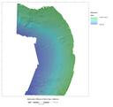 Quick view image of the bathymetry data in the offshore of Morro Bay study area.


Supplemental Files
- VersionHistory_P9HEZNRO.txt - 1.2 KB
Suggested Citation
Cochrane, G.R., Cole, A., Sherrier, M., and Roca-Lezra, A., 2022, Bathymetry, backscatter intensity, and benthic habitat offshore of Morro Bay, California (ver. 1.1, January 2024): U.S. Geological Survey data release, https://doi.org/10.5066/P9HEZNRO.
Revision History
First release: 2022
Revised: January 2024 (ver. 1.1)
Changes in Version 1.1
An attribute "Substrate" was added to the CMECS polygon dataset, and the metadata was updated with the attribute definitions.