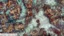
Overlapping seabed images and location data acquired using the SQUID-5 system at Looe Key, Florida, in July 2021, with structure-from-motion derived point cloud, digital elevation model and orthomosaic of submerged topography
By Gerry A. Hatcher, Christine J. Kranenburg, Jonathan A. Warrick, Stephen T. Bosse, David G. Zawada, Kimberly K. Yates, and Selena A. Johnson
https://doi.org/10.5066/P9WSF09G
Dates
Published: Oct. 5, 2022
Summary
Underwater images were collected using a towed-surface vehicle with multiple downward-looking underwater cameras developed by the U.S. Geological Survey (USGS). The system is named the Structure-from-Motion (SfM) Quantitative Underwater Imaging Device with Five Cameras (SQUID-5). The raw images and associated navigation data were collected at Looe Key, a coral reef located within the Florida Keys National Marine Sanctuary approximately eleven kilometers south of Ramrod Key, Florida. SQUID-5 was towed through the survey area using the 25' R/V Sallenger USGS support vessel during the data collection from July 15-July 19, 2021. The images and position data acquired by the SQUID-5 system were then processed using SfM photogrammetry techniques to generate the point cloud, digital elevation model, and full-color orthomosaic data products presented here. The goal of this work was to generate very high (millimeter scale) resolution maps and precisely co-registered, full-color, orthomosaic imagery of the seabed at Looe Key with accurate geospatial location to support ongoing USGS research, including seafloor elevation and stability modeling, and small-scale hydrodynamic flow modeling at millimeter scales over short time frames (event-driven and storms). These data will also enable other researchers and stakeholders to co-register and validate their imagery and ecological data in the area.
Imagery Data
-
Orthoimagery of Looe Key, Florida, 2021
A seabed orthoimage was developed from underwater images collected at Looe Key, Florida, in July 2021 using the SQUID-5 camera system. The underwater images were processed using Structure-from-Motion (SfM) photogrammetry techniques. The orthoimage covers a rectangular area of seafloor approximately 720x100 meters (0.072 square kilometers) in size. It was created using image-mosaicking methods and saved as a tiled GeoTIFF raster at 5-millimeter resolution.
Data Files
SQUID5_LKR_2021_Orthomosaic_5mm_A_1.zip - 2.0 GB
SQUID5_LKR_2021_Orthomosaic_5mm_B_0.zip - 181.0 MB
SQUID5_LKR_2021_Orthomosaic_5mm_B_1.zip - 2.4 GB
SQUID5_LKR_2021_Orthomosaic_5mm_C_0.zip - 1.3 GB
SQUID5_LKR_2021_Orthomosaic_5mm_C_1.zip - 1.3 GB
SQUID5_LKR_2021_Orthomosaic_5mm_D_0.zip - 2.4 GB
SQUID5_LKR_2021_Orthomosaic_5mm_D_1.zip - 220.6 MB
SQUID5_LKR_2021_Orthomosaic_5mm_E_0.zip - 1.7 GB
Metadata Files
SQUID5_LKR_2021_Ortho_5mm_metadata.xml - 36.1 KB
SQUID5_LKR_2021_Ortho_5mm_metadata.txt - 35.4 KB
Support Files
 Full-resolution sample view of larger orthomosaic image.
 -
Overlapping seabed images collected at Looe Key, Florida, 2021
A total of 94,567 underwater images were collected at Looe Key, Florida, in July 2021, using the SQUID5 Structure-from-Motion (SfM) system, a towed-surface vehicle with five downward-looking underwater cameras developed by the U.S. Geological Survey. The images are organized in zipped files grouped by survey line. The SQUID-5 records images in the Tagged Image File Format format to maintain the highest resolution and bit depth. Each image includes Exchangeable Image File (EXIF) metadata, containing Global navigation satellite system (GNSS) date, time, latitude, longitude, and altitude of the GNSS antenna mounted on the towed surface vehicle, copyright, keywords, and other fields.
Data Files
Line01.zip - 8.2 GB
Line02.zip - 7.7 GB
Line03.zip - 15.9 GB
Line04.zip - 10.4 GB
Line05.zip - 15.5 GB
Line06.zip - 10.1 GB
Line07.zip - 12.8 GB
Line08.zip - 10.3 GB
Line09.zip - 14.6 GB
Line10.zip - 9.6 GB
Line11.zip - 11.4 GB
Line12.zip - 6.9 GB
Line13.zip - 9.2 GB
Line14.zip - 10.3 GB
Line27.zip - 12.7 GB
Line28.zip - 12.7 GB
Line29.zip - 12.3 GB
Line30.zip - 14.7 GB
Line31.zip - 12.1 GB
Line32.zip - 13.0 GB
Line33.zip - 15.4 GB
Line34.zip - 4.0 GB
Line35.zip - 11.0 GB
Line36.zip - 11.1 GB
Line37.zip - 10.3 GB
Line38.zip - 14.1 GB
Line39.zip - 12.3 GB
Line40.zip - 15.5 GB
Line41.zip - 6.8 GB
Line42.zip - 12.7 GB
Line43.zip - 11.7 GB
Line44a.zip - 18.7 GB
Line44b.zip - 14.2 GB
Line45.zip - 15.0 GB
Line46.zip - 10.7 GB
Line47a.zip - 13.4 GB
Line47b.zip - 7.8 GB
Line62.zip - 16.8 GB
Line63.zip - 13.3 GB
Line64.zip - 16.3 GB
Line65.zip - 11.0 GB
Line66.zip - 17.6 GB
Line67.zip - 6.4 GB
Line68.zip - 9.4 GB
Line69.zip - 8.4 GB
Line70.zip - 12.1 GB
Line71a.zip - 12.7 GB
Line71b.zip - 14.9 GB
Line72a.zip - 13.7 GB
Line72b.zip - 14.7 GB
Line73.zip - 11.6 GB
Line74.zip - 11.7 GB
Line75.zip - 13.0 GB
Line76.zip - 13.8 GB
Metadata Files
SQUID5_LKR_2021_Raw_Imagery_metadata.xml - 20.0 KB
SQUID5_LKR_2021_Raw_Imagery_metadata.txt - 19.5 KB
 Example underwater image from one of the cameras.


Location-Elevation Data
-
Point cloud data of Looe Key, Florida, 2021
A three-dimensional point cloud (LAZ format) was developed from underwater images collected at Looe Key, Florida, in July 2021 using the SQUID-5 camera system and processed using Structure-from-Motion (SfM) photogrammetry techniques. Point cloud data include x,y,z positions, and RGB colors derived from the color-corrected imagery. LAS (and its compressed form, LAZ) is an open format developed for the efficient use of point cloud lidar data.
Data Files
SQUID5_LKR_2021_PointCloud_A_1.laz - 4.5 GB
SQUID5_LKR_2021_PointCloud_B_0.laz - 535.8 MB
SQUID5_LKR_2021_PointCloud_B_1.laz - 5.9 GB
SQUID5_LKR_2021_PointCloud_C_0.laz - 3.6 GB
SQUID5_LKR_2021_PointCloud_C_1.laz - 2.9 GB
SQUID5_LKR_2021_PointCloud_D_0.laz - 6.2 GB
SQUID5_LKR_2021_PointCloud_D_1.laz - 447.5 MB
SQUID5_LKR_2021_PointCloud_E_0.laz - 3.4 GB
Metadata Files
SQUID5_LKR_2021_PointCloud_metadata.xml - 30.3 KB
SQUID5_LKR_2021_PointCloud_metadata.txt - 29.9 KB
 Full-resolution sample view of larger point cloud data set.
 -
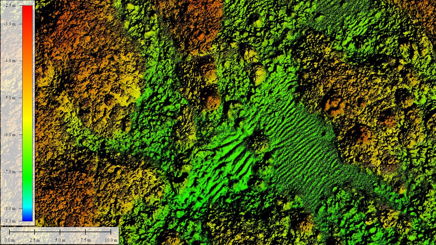
Digital elevation model (DEM) of Looe Key, Florida, 2021
A digital elevation model (DEM) was created from underwater images collected at Looe Key, Florida, in July 2021 using the SQUID-5 camera system. The underwater images were processed using Structure-from-Motion (SfM) photogrammetry techniques into a classified two-class ('unclassified' and 'low noise') 3D point cloud. The DEM was created in Metashape (ver. 1.6.6) from the point cloud, and includes points from both classes. The DEM covers a rectangular area of seafloor approximately 720x100 meters (0.072 square kilometers) in size and was saved as a tiled GeoTIFF raster at 1-centimeter resolution.
Data Files
SQUID5_LKR_2021_DEM_1cm-A-1.zip - 565.4 MB
SQUID5_LKR_2021_DEM_1cm-B-0.zip - 52.6 MB
SQUID5_LKR_2021_DEM_1cm-B-1.zip - 682.7 MB
SQUID5_LKR_2021_DEM_1cm-C-0.zip - 360.6 MB
SQUID5_LKR_2021_DEM_1cm-C-1.zip - 360.6 MB
SQUID5_LKR_2021_DEM_1cm-D-0.zip - 686.2 MB
SQUID5_LKR_2021_DEM_1cm-D-1.zip - 60.2 MB
SQUID5_LKR_2021_DEM_1cm-E-0.zip - 488.2 MB
Metadata Files
SQUID5_LKR_2021_DEM_1cm_metadata.xml - 31.1 KB
SQUID5_LKR_2021_DEM_1cm_metadata.txt - 30.7 KB
 Full-resolution sample view of the digital elevation model (DEM).
 -
GNSS locations of seabed images collected at Looe Key, Florida, 2021
The text file "SQUID5_LKR_2021_Image_Locations.txt" provides the GNSS antenna location for underwater images collected at Looe Key, Florida, in July 2021, using the SQUID5 Structure-from-Motion (SfM) system, a towed-surface vehicle with five downward-looking underwater cameras developed by the U.S. Geological Survey. The GNSS antenna location for the time of each image capture is presented with greater precision than is stored in the individual image EXIF headers due to decimal place limitations of the EXIF format.
Data Files
SQUID5_LKR_2021_Image_Locations.txt - 6.2 MB
Metadata Files

Suggested Citation
Hatcher, G.A., Kranenbug, C.J., Warrick, J.A., Bosse, S.T., Zawada, D.G., Yates, K.K., Johnson, S.A., 2022, Overlapping seabed images and location data acquired using the SQUID-5 system at Looe Key, Florida, in July 2021, with structure-from-motion derived point cloud, digital elevation model and orthomosaic of submerged topography: U.S. Geological Survey data release, http://doi.org/10.5066/P9WSF09G.
Overview Image
