Bathymetry and acoustic-backscatter data collected in 2016 offshore the Elwha River mouth, Washington, during USGS Field Activity 2016-605-FA
By Jonathan A. Warrick and Peter Dartnell
https://doi.org/10.5066/P9YVVAMT
Dates
Published: Nov. 4, 2020
Data Collected: Feb. 14, 2016 – Feb. 22, 2016
Summary
This data release provides bathymetry and acoustic-backscatter data collected during a 2016 SWATHPlus-M survey offshore the Elwha River mouth, Strait of Juan de Fuca, Washington. Data were collected and processed by the U.S. Geological Survey, Pacific Coastal and Marine Science Center during field activity 2016-605-FA. This survey, along with two other surveys (Cochrane and others, 2008, Finlayson and others, 2011) was conducted to map changes that have occurred following sediment input from dam removals from the Department of the Interior's Elwha River Restoration Project. This project resulted in the removal of two large dams on the Elwha River during 2011-2014, which released millions of tonnes of sediment to the river and coast. Collaborative partners in this work include the Lower Elwha Klallam Tribe.
References
Cochrane G.R., Warrick, J.A, Sagy, Y., Finlayson, D., and Harney, J., 2008, Sea-floor mapping and benthic habitat GIS for the Elwha River Delta nearshore, Washington: U.S. Geological Survey Data Series 320 [https://pubs.usgs.gov/ds/320/].
Finlayson, D.P., Miller, I.M., and Warrick, J.A., 2011, Bathymetry and acoustic backscatter—Elwha River Delta, Washington: U.S. Geological Survey Open-File Report 2011–1226 [https://pubs.usgs.gov/of/2011/1226/].
Sonar Data
-
Acoustic-backscatter data collected in 2016 offshore the Elwha River mouth, Washington, during USGS Field Activity 2016-605-FA
These metadata describe acoustic-backscatter data collected during a 2016 SWATHPlus-M survey offshore the Elwha River mouth, Strait of Juan de Fuca, Washington. Data were collected and processed by the U.S. Geological Survey (USGS), Pacific Coastal and Marine Science Center (PCMSC) with fieldwork activity number 2016-605-FA. The acoustic-backscatter data are provided as a GeoTIFF image in UTM, zone 10, NAD83 coordinates.
Data Files
2016_ElwhaDelta_2m_backscatter_UTM10_NAD83.zip - 5.0 MB
Metadata Files
2016_ElwhaDelta_2m_backscatter_UTM10_NAD83_metadata.xml - 16.9 KB
2016_ElwhaDelta_2m_backscatter_UTM10_NAD83_metadata.txt - 16.6 KB
 Quickview image of acoustic-backscatter data collected in 2016 offshore the Elwha River mouth, Strait of Juan de Fuca, Washington
 -
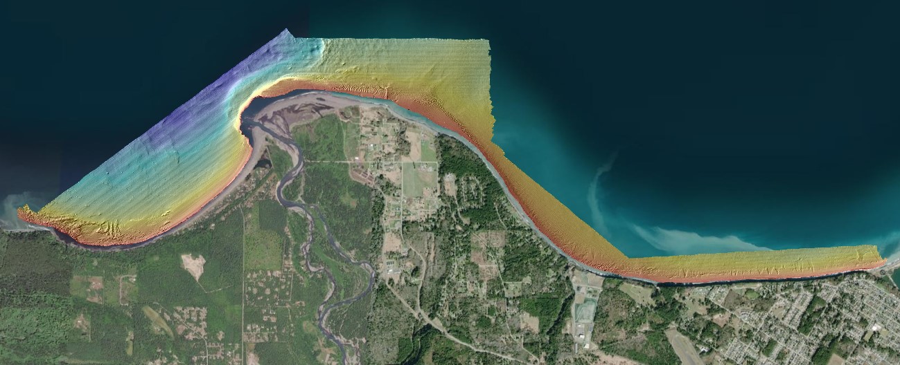
Bathymetry data collected in 2016 offshore the Elwha River mouth, Washington, during USGS Field Activity 2016-605-FA
These metadata describe bathymetry data collected during a 2016 SWATHPlus-M survey offshore the Elwha River mouth, Strait of Juan de Fuca, Washington. Data were collected and processed by the U.S. Geological Survey (USGS), Pacific Coastal and Marine Science Center (PCMSC) with fieldwork activity number 2016-605-FA. The bathymetry data are provided as a GeoTIFF image in UTM, zone 10, NAD83 coordinates, vertically referenced to NAVD88.
Data Files
2016_ElwhaDelta_2m_bathymetry_UTM10_NAD83_NAVD88.zip - 4.1 MB
Metadata Files
2016_ElwhaDelta_2m_bathymetry_UTM10_NAD83_NAVD88_metadata.xml - 17.6 KB
2016_ElwhaDelta_2m_bathymetry_UTM10_NAD83_NAVD88_metadata.txt - 17.3 KB
 Quickview image of bathymetry data collected in 2016 offshore the Elwha River mouth, Strait of Juan de Fuca, Washington


Related Field Activities
- 2016-605-FA - View Details
Suggested Citation
Dartnell, P., and Warrick, J.A., 2020, Bathymetry and acoustic-backscatter data collected in 2016 offshore the Elwha River mouth, Washington, during USGS Field Activity 2016-605-FA: U.S. Geological Survey data release, https://doi.org/10.5066/P9YVVAMT.
Overview Image