Time-series measurements of oceanographic and water quality data collected at Thompsons Beach and Stone Harbor, New Jersey, USA, September 2018 to September 2019 and March 2022 to May 2023
By Robert D. Bales, Steven E. Suttles, Olivia A. De Meo, Neil K. Ganju, and Eric D. Marsjanik
https://doi.org/10.5066/P9Z0Z8DM
Dates
Published: Jan. 13, 2024
Summary
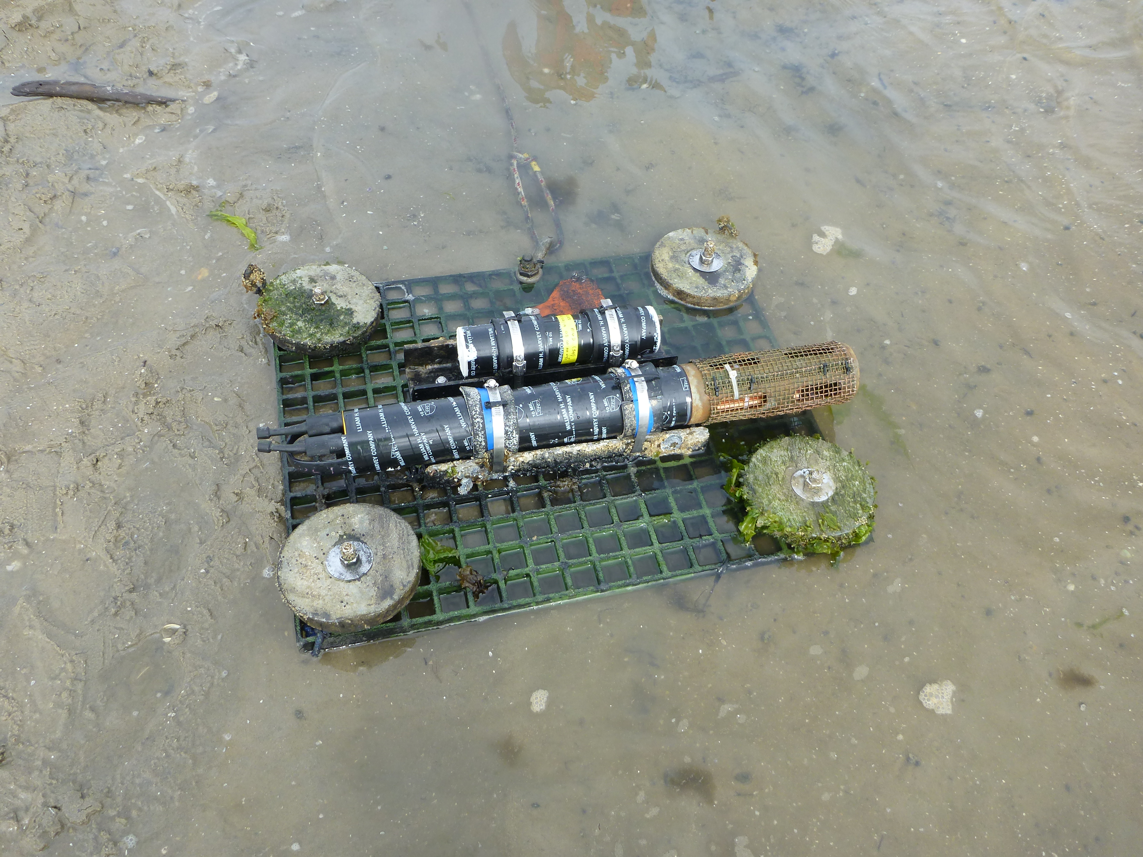
In October 2012, Hurricane Sandy made landfall in the Northeastern U.S., affecting ecosystems and communities of 12 states. In response, the National Fish and Wildlife Federation (NFWF) and the U.S. Department of Interior (DOI) implemented the Hurricane Sandy Coastal Resiliency Program, which funded various projects designed to reduce future impacts of coastal hazards. These projects included marsh, beach, and dune restoration, aquatic connectivity, and living shoreline installation, among others. To evaluate restoration efforts of the Hurricane Sandy Coastal Resiliency Program, the U.S. Geological Survey (USGS) studied two marsh sites of coastal systems in southeast New Jersey that underwent restoration. Submerged sensors were deployed to measure water velocity, water quality, water level, and waves. Water quality data collection included optical turbidity measurements that were calibrated to suspended sediment mass using in-situ, lab filtered water samples. These data will be used to calculate sediment fluxes and ecological resilience metrics at the two marsh sites.
Time Series Data
-
Time-series measurements of oceanographic and water quality data collected at Thompsons Beach and Stone Harbor, New Jersey, USA, September 2018 to September 2019 and March 2022 to May 2023
Submerged sensors were deployed to collect a time-series of water level, velocity, pressure, waves, flow, turbidity, pH, fluorescent dissolved organic matter (fDOM), chlorophyll, dissolved oxygen, blue-green algae, conductivity, and temperature data. These oceanographic and water quality data were collected to evaluate the effectiveness of marsh restoration projects at Thompsons Beach and Stone Harbor, New Jersey by determining net sediment flux as a metric for marsh resilience.
Data Files
11151Aiqflow-a.nc - 556.8 KB - MD5:d81442e9fe088db708550b0a4d1765dd
11151Biqflow-a.nc - 643.9 KB - MD5:b8dc79c01b6b4e3e65f8b2164c9981ca
11151Ciqflow-a.nc - 294.9 KB - MD5:6e2c34ce7a6a690f296fb4b845bcc7f7
11151Diqflow-a.nc - 2.3 MB - MD5:286148754fdba94f435d8c124b17e302
11151Eiqflow-a.nc - 1.3 MB - MD5:700bf1b6d30326107448ea5694dfd7bc
11161Aexo-a.nc - 1.1 MB - MD5:43d01441bb7bbe928ec173cb37b3989a
11161Bexo-a.nc - 1.2 MB - MD5:92d1b486fde6f84cd5d8ca6ea8c560b4
11161Cexo-a.nc - 869.1 KB - MD5:2e16dd17cd41bbdde7ab0de332a44caf
11161Dexo-a.nc - 1.2 MB - MD5:75a766698652783a733bef4b9bd2e663
11161Eexo-a.nc - 1.0 MB - MD5:56f46521c323fa414b746071b002fb01
11162Adwb-cal.nc - 289.1 MB - MD5:ddc2e56c3ab62fdd08933f15c582c1ff
11162Adws-a.nc - 61.9 MB - MD5:244a79c114b1528944e8e5a3e97a8aed
11162Bdwb-cal.nc - 319.1 MB - MD5:f555148033168454ebc3880901265065
11162Bdws-a.nc - 68.3 MB - MD5:eb5f99a39f82b77fe5598df8dd34bb83
11162Cdwb-cal.nc - 213.5 MB - MD5:47efc8c5a69a17c6fcc4f236a4f85cbb
11162Cdws-a.nc - 45.7 MB - MD5:dcc138aea65ff1b8c64ff241370c0918
11162Ddwb-cal.nc - 308.9 MB - MD5:7420ef5b69b8c320d17c4dae904992d1
11162Ddws-a.nc - 66.1 MB - MD5:20063a5cc8ab803006577bf5365797bf
11162Edwb-cal.nc - 266.2 MB - MD5:3127503fcbf1b914500191e926c9bc51
11162Edws-a.nc - 57.0 MB - MD5:efdaaf7141c5248cbf0aa83ee401448b
11181ABaqd-a.nc - 52.4 MB - MD5:de6b593d606f558c679d99ac442ec414
11181CDaqd-a.nc - 46.1 MB - MD5:8c727703ebd742e091a55f647720aa99
11181Eaqd-a.nc - 22.7 MB - MD5:5a77440c35af5f263aa686dc22188690
11191Aexo-a.nc - 1.1 MB - MD5:40c57873b238876c249684acf74a0198
11191Bexo-a.nc - 1.1 MB - MD5:b144936e469f5f64ba2ce82d4c6293a0
11191Dexo-a.nc - 1.2 MB - MD5:722d2acb68d5bc7684ee89ed95b5a6df
11191Eexo-a.nc - 1.0 MB - MD5:3906ea60df18db8dcca3df5e103ddce4
11192Adwb-cal.nc - 289.0 MB - MD5:2a0392e58bc7ab82ea42e25211ed87c8
11192Adws-a.nc - 61.8 MB - MD5:77eabb9921630f4a2df8ac3da34f32b0
11192Bdwb-cal.nc - 629.8 MB - MD5:4b1a6743faa87b9760ddb345121ab902
11192Bdws-a.nc - 134.7 MB - MD5:7637a067a10639f0e613b23100c8482d
11192Ddwb-cal.nc - 314.7 MB - MD5:8569758f024c61732496185aa2115c3a
11192Ddws-a.nc - 67.3 MB - MD5:896d3150815a072252ac17b6ff3723bd
11192Edwb-cal.nc - 259.3 MB - MD5:6bef5916a1fc5a59a1d0cbc82ca534fd
11192Edws-a.nc - 55.5 MB - MD5:4df23d4e68feb3dcdadabadb041cedb5
11501Aiqflow-a.nc - 2.2 MB - MD5:664c3809fca3f0fd48c8c22302485f2f
11501Biqflow-a.nc - 300.0 KB - MD5:c096d3e8764f12d29fa212282dc00398
11501Ciqflow-a.nc - 1.4 MB - MD5:9b23de51e96d633d6b99ffd6fe2e606d
11501Diqflow-a.nc - 2.0 MB - MD5:4eac249c46405430b18633316f3d06d8
11501Eiqflow-a.nc - 1.1 MB - MD5:8d216811bf8cdb4f0ffc14e60f33d64a
11511Aexo-a.nc - 1.1 MB - MD5:b9283d7e0b5ca9f97529617ea75c1c45
11511Bexo-a.nc - 983.7 KB - MD5:c3bdaa1f697ae9e7b332bf720137e725
11511Cexo-a.nc - 737.7 KB - MD5:f5ac361f5ac53b4b92c0eb8552559e3d
11511Dexo-a.nc - 1.0 MB - MD5:46d1f56a8406d4d0e4c017fef35666c3
11511Eexo-a.nc - 1.0 MB - MD5:f090866a6f0a03ae20046c14dd577fd5
11512Adwcont-cal.nc - 611.6 MB - MD5:3d32791e8984581306a578e6f649edaf
11512Adws-a.nc - 5.9 MB - MD5:bb33163edd86623e8fc1e77c0f55011c
11512Bdwcont-cal.nc - 521.1 MB - MD5:c4cd4e21b2d271a5ae5c84a6a4056e32
11512Bdws-a.nc - 5.1 MB - MD5:1b5a5220c2ed74c2612713a1b5f22f2f
11512Cdwcont-cal.nc - 375.6 MB - MD5:c6e5b3203b5ba8a455305185fabded36
11512Cdws-a.nc - 3.7 MB - MD5:223281c2d215aa856ee2cc4fa938e79e
11512Ddwcont-cal.nc - 550.0 MB - MD5:4842cd73e39bc51968649a46301ac733
11512Ddws-a.nc - 5.3 MB - MD5:a3c01c24d279c68afe15bd1bbd3b0fe0
11512Edwcont-cal.nc - 557.2 MB - MD5:d8d18e8190908afcf4cdf4c0767b3d3e
11512Edws-a.nc - 5.4 MB - MD5:535547e3d408f33c7e4e953377a1e760
11521ABaqd-a.nc - 29.8 MB - MD5:19a72ab30186268751348d786759585b
11521Caqd-a.nc - 9.9 MB - MD5:05dab4992ae22991c75f7251a1f9dcfd
11521DEaqd-a.nc - 53.4 MB - MD5:a9aadc1bdd776014f96ee0116e63e587
11531Aexo-a.nc - 1.1 MB - MD5:b9cb1d7a3e2b23ea2c87f1b79f93c975
11531Bexo-a.nc - 987.9 KB - MD5:9c734999414be80bdcaa65145f42c363
11531Cexo-a.nc - 724.7 KB - MD5:2a2884c5ed253ef86a680658b29f1bbd
11531Dexo-a.nc - 1.1 MB - MD5:c07764dbd599c1c1ab7dc66ca8cb48ac
11531Eexo-a.nc - 1022.6 KB - MD5:6721567bd6f4fa446c68b8e8c9d5983d
11532Adwcont-cal.nc - 607.7 MB - MD5:4fbbab8f4b9bfbbb3d6dcdf91b6d019d
11532Adws-a.nc - 5.9 MB - MD5:636626a2415e2a1ae7ca08113bba19d6
11532Bdwcont-cal.nc - 526.1 MB - MD5:12ec96a8430dba890a98b305862292c2
11532Bdws-a.nc - 5.1 MB - MD5:43907bf5ba5bad83a29099db5be2947a
11532Cdwcont-cal.nc - 366.3 MB - MD5:716f21fe3ba5f66ac7a8ffd660e50b0a
11532Cdws-a.nc - 3.6 MB - MD5:2d49c242e97fdca4ec95212f4f9a39d5
11532Ddwcont-cal.nc - 581.7 MB - MD5:df44f19f116839783889ce775931108a
11532Ddws-a.nc - 5.6 MB - MD5:3911ff17855500831b6d8dfe0c5599bb
11532Edwcont-cal.nc - 544.5 MB - MD5:43c21414f4947f25797d5b4402fce14e
11532Edws-a.nc - 5.3 MB - MD5:a463528db7474b6fa22538f905ad3cf7
NFWF_timeseries.zip - 4.9 GB - MD5:3beb0db3d842f6d148ea7fdba87e5eb2
Other Data Access
Metadata Files
NFWF_timeseries_metadata.xml - 42.0 KB
NFWF_timeseries_metadata.txt - 40.8 KB
Related Field Activities
- 2018-048-FA - View Details
- 2018-056-FA - View Details
- 2018-059-FA - View Details
- 2019-006-FA - View Details
- 2019-016-FA - View Details
- 2019-023-FA - View Details
- 2019-028-FA - View Details
- 2019-036-FA - View Details
- 2022-013-FA - View Details
- 2023-015-FA - View Details
- 2023-016-FA - View Details
Suggested Citation
Bales, R.D., Suttles, S.E., De Meo, O.A., Ganju, N.K., and Marsjanik, E.D., 2024, Time-series measurements of oceanographic and water quality data collected at Thompsons Beach and Stone Harbor, New Jersey, USA, September 2018 to September 2019 and March 2022 to May 2023: U.S. Geological Survey data release, https://doi.org/10.5066/P9Z0Z8DM.
Overview Image