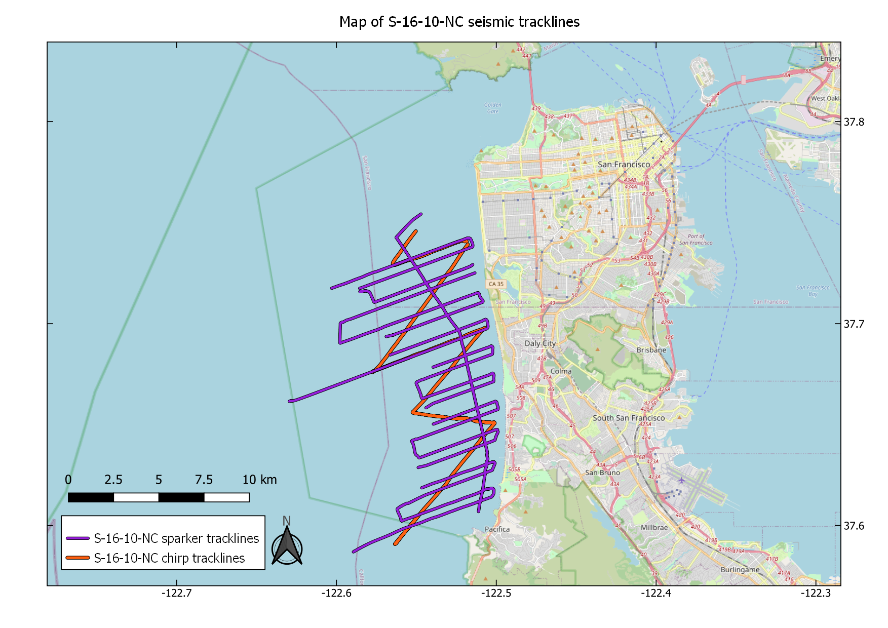
Minisparker and chirp seismic reflection data acquired offshore San Francisco and Pacifica during USGS field activity S-16-10-NC
By Alicia F. Balster-Gee, Ray W. Sliter, Stephanie L. Ross, and Holly F. Ryan
https://doi.org/10.5066/P9ZP0CBV
Dates
Published: Oct. 3, 2023
Summary
Chirp sub-bottom and single-channel minisparker seismic reflection data were collected by the U.S. Geological Survey in August 2010, offshore San Mateo County, California. Data were collected aboard the R/V Snavely during field activity S-16-10-NC. This work was funded by the USGS Coastal and Marine Geology Program’s Coastal and Marine Catastrophic Hazards project. The high-resolution seismic-reflection profiles provide shallow geologic structure, stratigraphy and fault geometry information for the San Gregorio, San Andreas, and Golden Gate faults to be used to update the USGS Quaternary fault database and to use in shaking-hazard models. Other objectives of the mission were to determine thickness of Holocene sediments and to verify surficial mapping. These data and information are intended for science researchers, students, policy makers, and the general public.
Seismic Data
-
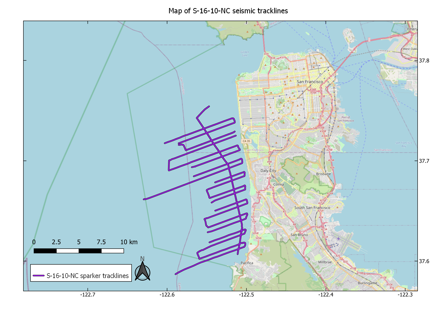
Minisparker seismic-reflection data acquired offshore San Francisco and Pacifica during USGS field activity S-16-10-NC
Single-channel minisparker seismic-reflection data were collected by the U.S. Geological Survey in August 2010, offshore San Mateo County, California. Data were collected aboard the R/V Snavely during field activity S-16-10-NC. Minisparker data were collected using a SIG 2-mille minisparker sound source combined with a single-channel streamer and recorded with a Triton SB-Logger.
Data Files
S-16-10-NC.sparker.zip - 1.8 GB - MD5:d58402d6ea9fff66185853ec741b3c5e
Metadata Files
S-16-10-NC.sparker.metadata.xml - 14.3 KB
S-16-10-NC.sparker.metadata.txt - 13.9 KB
 Map of minisparker seismic profiles acquired during USGS field activity S-16-10-NC
 -
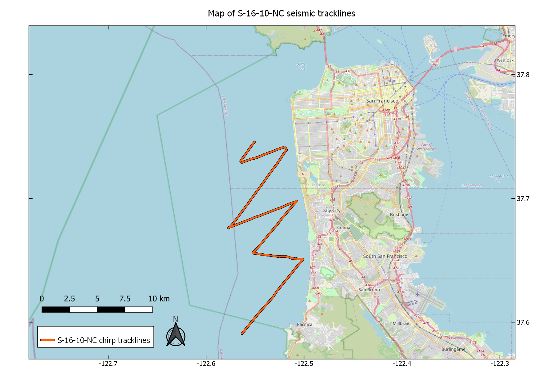
Chirp sub-bottom data acquired offshore San Francisco and Pacifica during USGS field activity S-16-10-NC
Chirp sub-bottom data were collected by the U.S. Geological Survey in August 2010, offshore San Mateo County, California. Data were collected aboard the R/V Snavely during field activity S-16-10-NC. Chirp data were collected using an Edgetech 512 chirp sub-bottom profiler.
Data Files
S-16-10-NC.chirp.zip - 773.3 MB - MD5:381371efbf36150d8bba8f5f90faf112
Metadata Files
S-16-10-NC.chirp.metadata.xml - 13.7 KB
S-16-10-NC.chirp.metadata.txt - 13.3 KB
 Map of chirp sub-bottom profiles acquired during USGS field activity S-16-10-NC
Suggested Citation
Balster-Gee, A.F., Sliter, R.W., Ross, S.L., Ryan, H.F., 2023, Minisparker and chirp seismic reflection data acquired offshore San Francisco and Pacifica during USGS field activity S-16-10-NC: U.S. Geological Survey data release, https://doi.org/10.5066/P9ZP0CBV.
Overview Image