JPEG Images of chirp subbottom profiler data collected by the U.S. Geological Survey in Moultonborough Bay, Lake Winnipesaukee, New Hampshire in 2005 (JPEG Image Format)

Metadata also available as - [Outline] - [Parseable text] - [XML]

Frequently anticipated questions:


What does this data set describe?

Title:
JPEG Images of chirp subbottom profiler data collected by the U.S. Geological Survey in Moultonborough Bay, Lake Winnipesaukee, New Hampshire in 2005 (JPEG Image Format)
Abstract:
In freshwater bodies of New Hampshire, the most problematic aquatic invasive plant species is Myriophyllum heterophyllum or variable leaf water-milfoil. Once established, variable leaf water-milfoil forms dense beds that can alter the limnologic characteristics of a waterbody, impacting natural lacustrine communities and their habitats. Variable leaf water-milfoil infestations also disrupt recreational uses of waterbodies and have negatively affected swimming, boating, fishing, and property values in and around several lakes and ponds in New Hampshire.
In 1965, Moultonborough Bay, Lake Winnipesaukee became the first waterbody in New Hampshire where variable leaf water-milfoil was observed. Variable leaf water-milfoil is native to the Southeastern and Midwestern areas of the United States where more alkaline waters appear to limit the growth of this plant. Outside its native range, however, it adapts well to the relatively acidic, low-alkalinity, and nutrient-poor conditions of oligotrophic lakes and bays similar to Moultonborough Bay.
In 2005, the New Hampshire Department of Environmental Services (NHDES) collaborated with the U.S. Geological Survey to investigate the distribution (presence and density) of variable leaf water-milfoil in Moultonborough Bay. This study utilized geophysical systems and conventional water-quality measurements to identify lake-floor environments that may provide suitable habitat for the establishment and growth of variable leaf water-milfoil. The results of the study are intended to assist resource managers in federal and state agencies by providing methods for detecting variable leaf water-milfoil and for identifying areas susceptible to infestation. Ultimately, this information may lead to early detection, prevention, and more effective mitigation strategies.
Field activity information for this cruise is available on-line through the U.S. Geological Survey Coastal and Marine Geoscience Data System https://cmgds.marine.usgs.gov/fan_info.php?fa=2005-004-FA.
  1. How might this data set be cited?
    U.S. Geological Survey, 2014, JPEG Images of chirp subbottom profiler data collected by the U.S. Geological Survey in Moultonborough Bay, Lake Winnipesaukee, New Hampshire in 2005 (JPEG Image Format): data release DOI:10.5066/F71N7Z4H, U.S. Geological Survey, Coastal and Marine Geology Program, Woods Hole Coastal and Marine Science Center, Woods Hole, Massachusetts.

    Online Links:

    This is part of the following larger work.

    Denny, J.F., Danforth, W.W., Worley, C.R., and Irwin, B.J., 2014, High-resolution geophysical and sample data collected in Moultonborough Bay, Lake Winnipesaukee, New Hampshire in 2005, USGS Field Activity 2005-004-FA: data release DOI:10.5066/F71N7Z4H, U.S. Geological Survey, Reston, VA.

    Online Links:

  2. What geographic area does the data set cover?
    West_Bounding_Coordinate: -71.390517
    East_Bounding_Coordinate: -71.361103
    North_Bounding_Coordinate: 43.728543
    South_Bounding_Coordinate: 43.710999
  3. What does it look like?
    https://cmgds.marine.usgs.gov/data/field-activity-data/2005-004-FA/data/seismics/2005-004-FA_chimages_sm.jpg (JPEG)
    Thumbnail image of chirp subbottom data collected by the U.S. Geological Survey in Moultonborough Bay, Lake Winnipesaukee, New Hampshire, 2005
  4. Does the data set describe conditions during a particular time period?
    Calendar_Date: 26-Jul-2005
    Currentness_Reference:
    ground condition
  5. What is the general form of this data set?
    Geospatial_Data_Presentation_Form: raster digital data
  6. How does the data set represent geographic features?
    1. How are geographic features stored in the data set?
      This is a Raster data set.
    2. What coordinate system is used to represent geographic features?
  7. How does the data set describe geographic features?

Who produced the data set?

  1. Who are the originators of the data set? (may include formal authors, digital compilers, and editors)
  2. Who also contributed to the data set?
  3. To whom should users address questions about the data?
    Jane F. Denny
    U.S. Geological Survey
    Geologist
    384 Woods Hole Road
    Woods Hole, Massachusetts
    USA

    508-548-8700 x 2311 (voice)
    508-457-2310 (FAX)
    jdenny@usgs.gov

Why was the data set created?

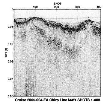
JPEG images of each seismic profile were generated in order to incorporate images of the seismic data into Geographic Information System (GIS) projects and data archives utilizing HTML. These JPEG images represent 37 km of chirp seismic data collected in 2005 during USGS field activity 2005-004-FA. This format is universal and yields an easily viewable image of the seismic profiles. Corresponding trackline navigation is contained within a polyline shapefile (2005-004-FA_chirptrk.shp), shot-point locations are available in a point shapefiles (2005-004-FA_chirpsht.shp).

How was the data set created?

  1. From what previous works were the data drawn?
    none (source 1 of 1)
    U.S. Geological Survey, Unpublished Material, Raw Chirp Subbottom Data.

    Type_of_Source_Media: online
    Source_Contribution:
    Chirp subbottom data were acquired with an Edgetech SB-424 chirp subbottom profiler. The SB-424 was deployed off the port side of the USGS R/V Rafael and towed close to the lake surface. Approximately 37 km of chirp subbottom data were collected.
    Data were recorded at a 75-millisecond (ms) record length (1875 samples, 40 microsecond sample interval) and a 4-24 kHz sweep and were logged using Triton-Elics Delph seismic acquisition software (version 2005) in Society of Exploration Geophysicists Y (SEG-Y) format (Barry and others, 1975) with WAAS navigation logged to the SEG-Y file trace headers. Navigation in the SEGY header was stored as seconds of arc. The raw chirp SEGY contained 3 channels: raw, match-filtered, envelope detected. The envelope detected channel was used for data processing.
  2. How were the data generated, processed, and modified?
    Date: 2005 (process 1 of 5)
    A C-shell script was executed using Sioseis (v. 2011.2.7) to read the raw SEG-Y file and write out a new SEG-Y file with the shots renumbered starting at 1. A second C-shell script was executed using Seismic Unix (version 4.1) to read the renumbered SEG-Y files, write a Seismic Unix format file (*.su), and extract SEG-Y trace header information, which included shot number, source x (arc seconds), source y (arc seconds), year, Julian Day, hour, minute, second (UTC). Geographic coordinates (stored in arc seconds WGS84) were converted to eastings and northings, UTM, Zone 19N, meters using proj (v. 4.7.1). Before saving the header information to a text file, the data were filtered using AWK (no version) to save only unique shot point locations. The unique shot navigation for each seismic line were then concatenated into a comma delimited (.csv) text file. The header records for the first several shots contained no navigation information, therefore the 'first' shot of the line is considered the first shot with usable data stored in the header. This was generally within the first 10 shots for the majority of lines. (Stockwell, 2005)
    Jane F. Denny performed this and all subsequent process steps.
    Date: 2013 (process 2 of 5)
    A C-Shell script using Seismic Unix (version 4.1) to read the SEG-Y files and plot the data as 8-bit gray scale Postscript files using the Seismic Unix 'psimage' algorithm was then executed. All images were created with a horizontal scale of 40 traces per inch. The profiles contain 50 milliseconds of Two-Way Travel Time within an 8-inch vertical window, yielding 6.25 milliseconds per inch. Postscript images were converted to JPEG format using the UNIX ImageMagick (version 5.5.6). The y-axis units are two-way travel time in seconds. The units of the x-axis of the images are shot numbers. The small tick marks represent 10 shot intervals, with the larger tick marks and labels at a 100 shot interval. The x-axis label indicates the USGS cruise ID and the number of shots in the seismic record.
    Date: 06-Apr-2017 (process 3 of 5)
    The online links to the data were updated to reflect the new server hosting the data. Additionally, other small edits could be made to the metadata, such as modifying http to https where appropriate. The metadata date (but not the metadata creator) was edited to reflect the date of these changes. Person who carried out this activity:
    U.S. Geological Survey
    Attn: VeeAnn A. Cross
    Marine Geologist
    384 Woods Hole Road
    Woods Hole, MA

    508-548-8700 x2251 (voice)
    508-457-2310 (FAX)
    vatnipp@usgs.gov
    Date: 20-Jul-2018 (process 4 of 5)
    USGS Thesaurus keywords added to the keyword section. Person who carried out this activity:
    U.S. Geological Survey
    Attn: VeeAnn A. Cross
    Marine Geologist
    384 Woods Hole Road
    Woods Hole, MA

    508-548-8700 x2251 (voice)
    508-457-2310 (FAX)
    vatnipp@usgs.gov
    Date: 08-Sep-2020 (process 5 of 5)
    Added keywords section with USGS persistent identifier as theme keyword. Person who carried out this activity:
    U.S. Geological Survey
    Attn: VeeAnn A. Cross
    Marine Geologist
    384 Woods Hole Road
    Woods Hole, MA

    508-548-8700 x2251 (voice)
    508-457-2310 (FAX)
    vatnipp@usgs.gov
  3. What similar or related data should the user be aware of?
    Argue, Denise M., Kiah, Richard G., Denny, Jane F., Deacon, Jeffrey R., Danforth, William W., Johnston, Craig M., and Smagula, Amy P., 2007, Relation of Lake-Floor Characteristics to the Distribution of Variable Leaf Water-Milfoil in Moultonborough Bay, Lake Winnipesaukee, New Hampshire, 2005: Scientific Investigations Report 2007-5125, U.S. Geological Survey, Reston, Virginia.

    Online Links:

    Stockwell, John, 2005, Seismic Un*x: Center for Wave Phenomena - Colorado School of Mines, Golden, Colorado, USA.

    Online Links:

    Barry, K.M., Cavers, D.A., and Kneale, C.W., 1975, Report on recommended standards for digital tape formats: Geophysics v. 40, no. 02, p. 344-352., Society of Exploration Geophysicists (SEG), Houston, Texas.

    Online Links:


How reliable are the data; what problems remain in the data set?

  1. How well have the observations been checked?
  2. How accurate are the geographic locations?
    Navigation was acquired with Wide Area Augmentation System ( WAAS), which is accurate to + or - 1 to 2 meters, horizontally. Navigation data were acquired with a LGBX Pro receiver and sent to Triton-Elics Delph seismic acquisition software, where Chirp sub-bottom data were recorded in Society of Exploration Geophysicists Y (SEG-Y) format (Barry and others, 1975) with DGPS logged to the SEG-Y trace headers.
    The Edgetech SB-424 chirp subbottom profiler was towed near the surface, close to the R/V Rafael. The instrument was secured in this position throughout the survey. Due to this tow configuration, any layback minimal. The overall horizontal accuracy, given even a small (~ 1 meter) offset between the WAAS antenna and the tow-body, is + or - 5 meters.
  3. How accurate are the heights or depths?
  4. Where are the gaps in the data? What is missing?
    Acquired chirp seismic data (Lines 43 - 112) were processed and JPEG images produced.
  5. How consistent are the relationships among the observations, including topology?
    All subbottom data were collected during USGS cruise 2005-004-FA using an Edgetech SB-424 chirp subbottom profiler. Processed chirp seismic data (lines 43 - 112) were converted to JPEG format for ease of seismic trace display. Quality control was conducted during processing.

How can someone get a copy of the data set?

Are there legal restrictions on access or use of the data?
Access_Constraints: None.
Use_Constraints:
Public domain data from the U.S. Government are freely redistributable with proper metadata and source attribution. Please recognize the U.S. Geological Survey as the originator of the dataset.
  1. Who distributes the data set? (Distributor 1 of 1)
    Jane F. Denny
    U.S. Geological Survey
    Geologist
    384 Woods Hole Road
    Woods Hole, Massachusetts
    USA

    508-548-8700 x2311 (voice)
    508-457-2310 (FAX)
    jdenny@usgs.gov
  2. What's the catalog number I need to order this data set? The file 2005-004-FA_chimages.zip contains the the chirp sub-bottom seismic-reflection profile JPEG images. In addition to the profile images, the zip file also contains the browse graphic (2005-004-FA_chimages_sm.jpg) and the FGDC CSDGM metadata in the following formats: XML, HTML, FAQ and text.
  3. What legal disclaimers am I supposed to read?
    Neither the U.S. Government, the Department of the Interior, nor the USGS, nor any of their employees, contractors, or subcontractors, make any warranty, express or implied, nor assume any legal liability or responsibility for the accuracy, completeness, or usefulness of any information, apparatus, product, or process disclosed, nor represent that its use would not infringe on privately owned rights. The act of distribution shall not constitute any such warranty, and no responsibility is assumed by the USGS in the use of these data or related materials. Any use of trade, product, or firm names is for descriptive purposes only and does not imply endorsement by the U.S. Government.
  4. How can I download or order the data?
  5. What hardware or software do I need in order to use the data set?
    This zip file contains data available in JPEG format. The zip file also contains associated metadata.

Who wrote the metadata?

Dates:
Last modified: 18-Mar-2024
Metadata author:
Jane F. Denny
U.S. Geological Survey
Geologist
384 Woods Hole Road
Woods Hole, Massachusetts
USA

508-548-8700 x2311 (voice)
508-457-2310 (FAX)
whsc_data_contact@usgs.gov
Contact_Instructions:
The metadata contact email address is a generic address in the event the person is no longer with USGS. (updated on 20240318)
Metadata standard:
FGDC Content Standards for Digital Geospatial Metadata (FGDC-STD-001-1998)

Generated by mp version 2.9.50 on Thu Mar 28 16:00:19 2024