|
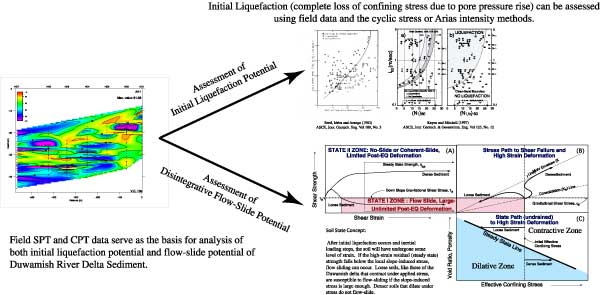
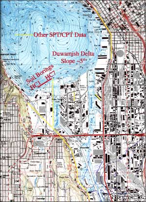
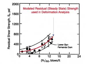
A fully developed commercial-industrial corridor, extending the City of Kent to the Elliott Bay/Harbor Island marine terminal facilities, is founded on the young Holocene deposits of the Duwamish River valley. These deposits primarily consist of deltaic overbank-, pointbar-, and channel-infill and extensive laharic material, all deposited less than 5000 y.b.p. A geotechnical investigation of these river-mouth deposits is underway to evaluate the initial liquefaction potential and seismic stability (flow failure potential) of the soils, and the impact ground failure would have on the built-infrastructure of the river valley. Modification of the ground surface by man to construct airfields, industrial facilities, and navigable waterways has resulted in extensive regrading of the ground surface, infill of wetlands, and the dredging and river training of native channels. To assess the morphology of the delta, obscured by mans activities, we used ground penetrating radar (GPR) to image the buried structure of the deltaic deposits. An extensive catalog of soil boring data taken along the valley axis for a variety of engineering-construction projects is used to groundtruth the radar imagery and to characterize the fill and native deposits. Stability of the Holocene soil using the Standard Penetration Test (SPT); Cone Penetration Test (CPT); and shear wave velocity field methodologies indicates that extensive soil liquefaction and ground failure of deltaic deposits are likely during events Magnitude 7. This ground damage will likely have significant adverse effect on commerce conducted within the industrial corridor. Click on figures to view larger image We are investigating the potential for initial liquefaction and disintegrative flow-failure in native soil of the Duwamish River Delta by relating field measured geotechnical test data to design-basis earthquake scenarios. The two design-basis earthquakes are (1) a shallow crustal fault event centered in the upper 20 km of M=7.0-7.5 and (2) a Benioff-Zone event of M=8+. Results presented here are for the response of the delta front (a subset of 100+ SPT and CPT soundings in our catalog) to a M=7.5 event. Study Area and Boring Locations
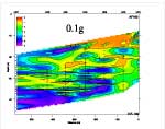
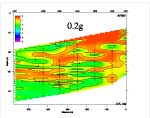
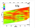
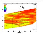
Factors of Safety against liquefaction occurrence (Fs <1.0 predicts liquefaction) for a M=7.5 event with peak accelerations ranging from 0.1g-0.4g.
Click on a figure to view larger image
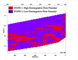
Duwamish River Delta Seismic Stability — Conclusions based on Design-Basis M=7.5 Event Initial Liquefaction Potential: Extremely High! Flow-Slide Potential: Uncertain, Between 10-20m numerous soil elements are in State 1. If the elements are isolated then massive flow-sliding should not occur. If the elements are interconnected along a layer(s) then massive flow-sliding will likely occur. |
||||||||
|
Top | Poster | About Poster | Index Page 

|
geotech/duwamishposter/poster.html
contact: Robert Kayen
last modified 2018
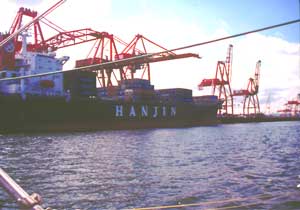 Port of Seattle, Harbor Island Facility