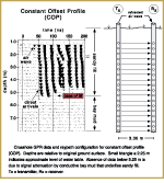
USGS PCMSC

Blast-Induced Liquefaction and Determination of Soil-Density Changes
with Ground-Penetrating Radar, Treasure Island, CA

Index Back to poster home page About these Web Pages Acknowledgments Conclusions Relations and Results Treasure Island Objectives Abstract Radar Methods

Crosshole GPR is a transillumination method in which two antennas are lowered down adjacent, parallel boreholes. The transmitter antenna emits a short pulse, or shot, of high frequency (100 MHz in this case) electromagnetic energy. The receiving antenna, located in the other borehole, precisely measures the time required for the signal to travel through the ground, along the plane separating the two boreholes. Careful calibrations are required to establish the travel time of the signal. In the field, 32 shots were collected at each antenna position. The multiple shots were "stacked" or added together to improve data quality and reduce noise.

Two different types of crosshole surveys were conducted: 1) a constant offset profile (COP), and 2) a multiple offset gather (MOG). The COP is a quick, reconnaissance type of survey in which both GPR antennas were lowered to equal depths down the boreholes for each shot. We used the COP to rapidly identify, in the field, anomalies in travel time and signal strength that would indicate variations in sediment properties. The COP data was also used to distinguish the hydraulic fill from Bay Mud and design a plan for more detailed radar surveys in the fill.

The MOG is a more detailed crosshole survey in which the transmitter antenna is fixed at a certain depth in one borehole while the receiver is moved in regular steps down the other. After the receiver collects shots from top to bottom (one complete MOG), the transmitter is lowered a predetermined step-interval and fixed at that new position, and the receiver is again moved down the other hole. The process is repeated until the transmitter reaches the bottom. In this study, we collected a suite of MOGs, each with a step-interval of 0.25 m. Unlike a COP, the path lengths in a MOG vary greatly from shot to shot. For each transmitter-receiver orientation, the path length is computed. In a perfectly homogeneous medium, the first arrivals would form a hyperbola. Deviations from a smooth hyperbolic pattern are indicative of variations in soil properties.

COP GPR profile

COP

Crosshole GPR data and raypath configuration for constant offset profile (COP). Depths are relative to original ground surface. Small triangle a 2.25 m indicates approximate level of water table. Absence of data below 5.25 m is due to signal attenuation by conductive bay mud that underlies sandy fill. Tx = transmitter, Rx = receiver.

Click on figure for larger image (36K).

MOG GPR profile

MOG

Crosshole GPR data and raypath configuration for a multiple offset gather (MOG) at Treasure Island. Transmitter (Tx) was fixed at a given position for each of 27 data files (only two shown here). Depth scale on the data files is relative to original ground surface, and indicates the position of the receiver (Rx) as it was lowered down hole. Small circles in the boreholes at right depict individual antenna positions.

Click on figure for larger image (57K).

TOMOGRAPHIC MANIPULATION

Substantial processing of crosshole GPR data is required before interpretable images are produced. Tomographic analysis utilizes the path length and precise measurements of one-way travel time to determine the velocity structure of the intervening materials. The positions of the transmitter and receiver antennas in the boreholes are well known, and therefore the raypath distance between the two is accurately calculated for each shot. The objective is to collect travel-time data along as many ray paths and along as many different angles as possible. The analysis first divides the single plane connecting the boreholes into a grid of cells, or pixels, and calculates the number of raypaths that intersect each cell. The result is a matrix of simultaneous velocity equations with a non-unique solution. The analysis then diverges from an initial estimated model of velocity structure to find a ‘best fit’ velocity with the observed data. The more raypaths or "hits" for each cell, the better definition of transmission properties. Fewer raypaths provide a less certain solution. For this reason, data quality is often low in the corners and edges of tomographic images, and we use only the high quality data from the center. Tomographic Manipulation Cartoon

geotech/treasureposter/radar.html
contact: Robert Kayen
last modified 2019