
The December 26, 2004 Indian Ocean Tsunami: Initial Findings on Tsunami Sand Deposits, Damage, and Inundation in Sri Lanka
Survey Site Locations and Photos
MankerniClick photo to see a larger image |
|
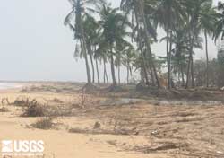 Erosion exposed roots of palm trees near the coast. Debris in foreground was transported by the return flow of the tsunami. (larger image, 157 kb) |
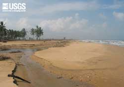 Tsunami erosion caused up to 20 m of coastal retreat at Mankerni. The beach is recovering, indicated by the new berm being formed by wind-geneated waves and tides (right of the photograph). (larger image, 88 kb) |
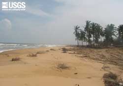 Debris on the beach at Mankerni transported by the return flow of the tsunami. The debris is being buried by a new beach berm that formed after the tsunami. (larger image, 91 kb) |
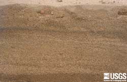
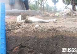 Tsunami deposit approximately 140 m from the shoreline. The deposit is between 0.5 and 1.5 cm thick. Note the root sticking out of the pre-tsunami soil. (larger image, 188 kb) |
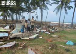 Eyewitnesses to December 26, 2004 tsunami standing on remains of house where they were when they first realized a tsunami was coming. (larger image, 185 kb) |
 Tsunami deposit approximately 105 m from the shoreline. The deposit is between 2 and 3.5 cm thick. Note the small roots sticking out of the pre-tsunami soil. (larger image, 146 kb) |
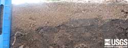
 Tsunami deposit approximately 70 m inland from the shoreline. The deposit is approximately 11 cm thick and composed of multiple layers. The pre-tsunami soil is the darker layer in the bottom part of the photograph. (larger image, 268 kb) |
 Erosion of grassy area approximately 40 m inland at Mankerni. Tsunami sand deposits were 10 cm thick 20 m inland of where this photograph was taken. The transition from erosion to deposition was at about 50 m inland. (larger image, 165 kb) |
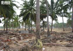 View looking inland at Mankerni, approximately 75 m from the shoreline. Debris covers a tsunami deposit on the ground. A fishing net and gouge marks on the tree in the center of the photograph indicate the water depth of the tsunami was more than 2.5 m at this location. (larger image, 226 kb) |
 Gouge marks in tree formed by debris carried by the tsunami indicate tsunami height of greater than 2 m at about 150 m from the shoreline at Mankerni. (larger image, 219 kb) |
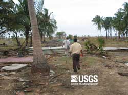 The tsunami removed houses about 75 m inland at Mankerni—all that is left is their foundations. Note the boats transported inland by the tsunami. The hole in the lower right portion of the photograph was made by the ITST when it examined tsunami sand deposits. (larger image, 145 kb) |
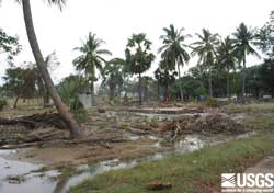 Ponded water from the tsunami at approximately 150 m from the shoreline. Note the foundation in the background that no longer has a house on it. (larger image, 159 kb) |