
The December 26, 2004 Indian Ocean Tsunami: Initial Findings on Tsunami Sand Deposits, Damage, and Inundation in Sri Lanka
Survey Site Locations and Photos
Nalaveli HotelClick photo to see a larger image |
|
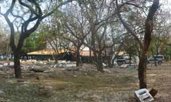 Photo taken about 100 m inland at the Nalaveli Hotel on Sri Lanka's east coast. (see the full-size panorama) |
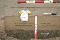 Tsunami sand deposit at Nalaveli Hotel. The sand deposited by the tsunami is light colored and overlies a pre-tsunami darker sandy soil. This tsunami deposit is approximately 15 cm thick and composed of three thick layers defined by darker areas (heavy mineral layers) and sub-layers that are visible near the surface. Grain size analysis in the lab will be used to determine whether the deposit was formed by three or more waves. A numerical model (Jaffe and Gelfenbaum, 2002) will be run using the field and lab data to estimate tsunami flow velocity at this location. Figure courtesy of Bretwood Higman, University of Washington. (larger image, 171 kb) |
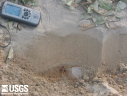 Oblique cut of tsunami deposit. The deposit is approximately 100 meters inland of the shoreline. (larger image, 78 kb) |
 Taking sediment samples for grain-size analysis, microfossil content, mineralogy, and chemistry. Laboratory analyses of the samples, in conjunction with modeling, give information about where the tsunami brought the sand from and flow during the tsunami. (larger image, 142 kb) |
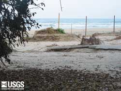 Erosion created small islands of pre-tsunami soil. Erosion here was less than 1 m in the vertical. (larger image, 194 kb) |
|