
Preliminary Analysis of Sedimentary Deposits from the 1998 Papua New Guinea (PNG) Tsunami
Introduction to 1998 PNG Tsunami and 2nd ITST
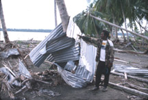
On July 17, 1998 a magnitude 7.0 earthquake was followed by a series of catastrophic tsunami waves that devastated several villages on the north coast of Papua New Guinea (PNG). Early eyewitness accounts reported waves 7-10 m high at the coast. Confirmed deaths were in the thousands, and several villages had been totally destroyed. In order to assess the nature of the tsunami that struck this isolated stretch of coast, and to determine the cause of the large waves, the international tsunami community conducted a field survey of the area. Within a few weeks of the devastating tsunami, a multi-national team of scientists and engineers from Japan, the United States, Australia, and New Zealand entered the region installing seismographs, measuring water levels, and interviewing eyewitnesses. This team became known as the 1st International Tsunami Survey Team (ITST).
Soon after the first team returned, a second group of international scientists became organized to retrieve the seismographs, collect more water-level and velocity data, assess damage to buildings and structures, and to examine the sediments left behind by the tsunami. The 2nd ITST arrived in Aitape, Papua New Guinea on September 29, 1998 and included representatives from Japan, the United States, Korea, and Papua New Guinea. This web page describes the efforts of the USGS scientists who participated in the 2nd ITST.
In the past decade the international tsunami community has responded to nine major tsunami disasters around the world, including Nicaragua (1992), Flores (1992), Okushiri (1993), East Java (1994), Mindoro (1994), Kuril Islands (1994), Manzanillo (1995), Indonesia (1996), and Peru (1996). The ultimate purpose of these rapid response surveys is to help managers and planners mitigate against future tsunami hazards. Improvement in our understanding of tsunamis will come from continued research, which must include data collected immediately after an event, as much of the information is altered or destroyed over time.
Why Study the Sediments?
When sediment is deposited by a tsunami and preserved, a geologic record of that tsunami is created. By looking at the sedimentary record in an area, geologists may be able to identify such deposits and infer the occurrence of past tsunamis. The recognition of deposits from past tsunamis allows geologists to extend the relatively short or non-existent historical record of tsunamis in an area. Because scientists cannot yet predict when a tsunami will occur, obtaining a geologic record of past events may be one of the only means to assess future risk.
A primary goal of the 2nd ITST was to determine whether or not the July 17, 1998, Papua New Guinea tsunami produced a recognizable sediment deposit, and if it did, what were its characteristics. The ability to interpret the height, power, and extent of a tsunami from its deposits is not only valuable for understanding the July 17 event, but also for identifying and deciphering tsunamis deposits, both ancient and modern, worldwide. Another goal of the survey was to determine whether the geologic record in the area effected by the July 17 tsunami contains information about past tsunamis.
Sample Locations and Tsunami Deposit Photos
USGS and PNG scientists made measurements of land elevation, flow depth, flow direction, and tsunami deposit thickness and character along cross-shore transects at four sites (Figure 1). The transects were located, from west to east, at Sissano Village, East-Sissano Spit (near the inlet to Sissano Lagoon), Arop School, and Waipo Village. Results at the four sites were similar; details of the Arop School transect will be described here.
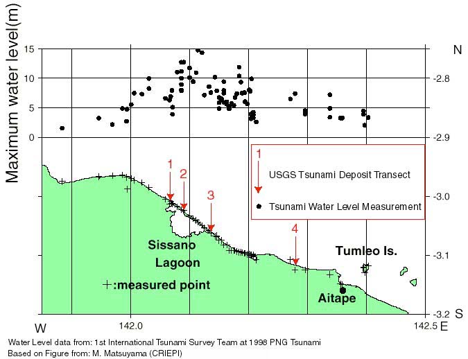
Figure 1: Location of USGS Tsunami Deposit Transects and water level measured by the 1st ITST. Transects were made at four sites:
- Sissano Village,
- East Sissano Spit near the inlet to the lagoon,
- Arop School, and
- Waipo Village.
The Arop School transect (Figure 2) was near the village of Arop, which was totally destroyed by the tsunami. Small pits were dug along this transect to examine the deposits left by the July 17 tsunami. The deposits were measured and described in the field and samples were taken for laboratory analyses (Figure 3).
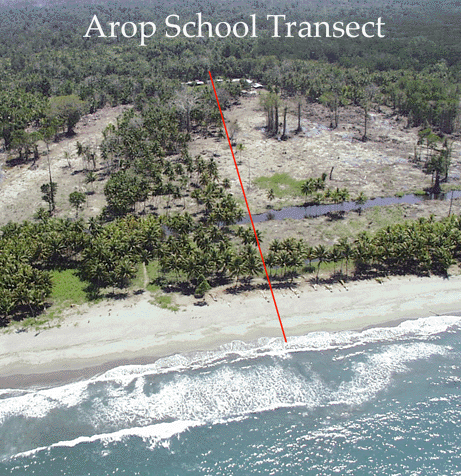
Figure 2: Location of the Arop School transect. Tsunami sand deposited across the coastal plain is a lighter color where it is not buried by a thin layer of mud. The July 17, 1998 tsunami deposited sand more than 650 m inland. Tsunami sand was found on the Arop Community School field (located between buildings shown at the top of the photo).

Figure 3: Taking samples of sand deposited by July 17, 1998 tsunami.
Tsunami deposits were common and were identified as gray-colored sand typically overlying a brown, rooted soil (Figure 4). In places, plants were found bent over and buried by the sand. In other places, plants and roots were removed by the tsunami, leaving an erosive base to the deposit. The lower part of the tsunami deposit may include rip-up clasts of the underlying muddy soil (Figure 5).
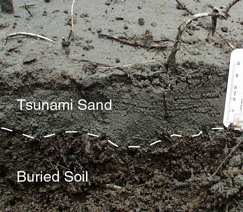
Figure 4: Typical tsunami deposit from Arop transect. The tsunami deposited a gray-colored sand, here about 5 cm thick, on a brown soil containing roots.
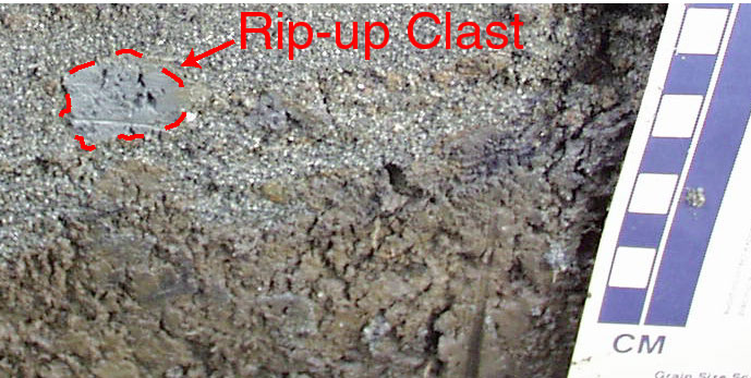
Figure 5: Mud rip-up clast in tsunami sand. A 2-cm gray colored mud rip-up clast is visible in the upper left corner of this photo.
The recently deposited tsunami sand is believed to have come from offshore of the beach as numerous sand dollars were found near the surface of the deposit. Another common characteristic of recently deposited tsunami sand was normal grading (a decrease in the size of the sand grains from the bottom to the top in the deposit) (Figure 6).
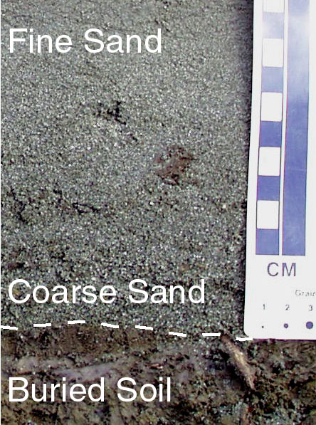
Figure 6: Deposit from July 17, 1998 tsunami overlying brown muddy soil. The sandy tsunami deposit is graded (larger grains at bottom of the deposit) and contains mud clasts ripped up from the soil.
Preliminary Results from Analysis of PNG Tsunami Deposits
Little internal structure was found in the tsunami deposits, although in a few places some faint horizontal stratification was observed at the top of the deposit. Overall, the recently deposited tsunami sand was relatively uniform in thickness (5-10 cm), and extended from 60 to 675 m inland, pinching out 50 m from the maximum limit of runup (Figure 7). The deposit fined landward (near the shore the sand particles were larger than the sand farther inland). Local variations in the thickness of the sand deposit were associated with small local topographic variations.
Information from the 1st ITST suggested that the maximum water level near the beach at this transect site was approximately 10 m. Flow depth indicators (e.g., water marks on structures, debris wrapped around a tree or other obstruction) further inland, about 500 m from the shoreline, record maximum water depths of 1-3 m.
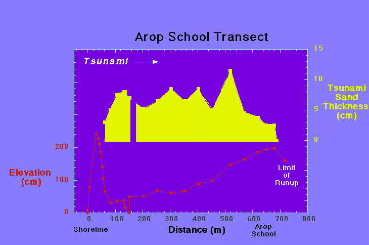
Figure 7: Tsunami sand thickness and land-surface profile at Arop School transect. The July 17, 1998 tsunami deposited sand across more than 600 m of coastal plain. Tsunami sands were up to 12 cm thick along the transect and thinned at its furthest landward extent. An erosional zone (here about 60 m wide) near the ocean, a thickening of tsunami sands landward of the erosional zone as depositional processes became stronger, and a thinning of tsunami sands near the landward extent of runup were observed at all four transects.
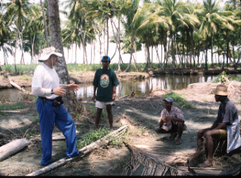
The Arop School transect was chosen as a good site to look down into the sedimentary record for evidence of past tsunamis. Away from sandy river or ocean sources, the depositional environment at this site was probably that of a quiet water lagoon. At 135 m from the shoreline, several long push cores were taken and described (Figure 8). Several 2-m long cores were taken and described, and one 4-m long core was obtained. The top meter of each core is characterized by a 5-10 cm thick normally graded sandy layer at the surface (deposited by the July 17 tsunami); this is underlain by 20-30 cm of a brown muddy soil. Beneath the soil is a uniformly gray muddy sediment. A thin coarse silt/fine sand layer is present approximately 120 cm below the surface. This layer is 3-4 cm thick and was found at a similar depth in each of the cores. This layer was likely deposited by a past tsunami. Material just below this fine-sand layer was obtained for possible dating to determine the approximate age of this thin layer.
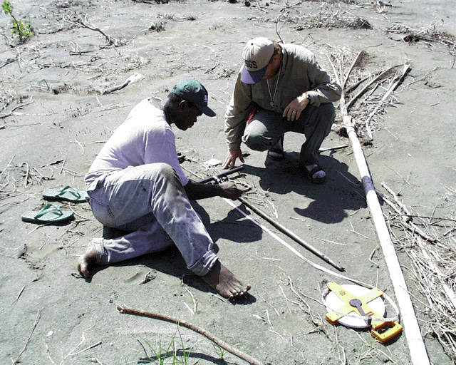
Figure 8: USGS and University of Papua New Guinea scientists examining core for evidence of past tsunamis. This core was taken on the Arop School transect. The sand surface the scientists are on was deposited in the July 17, 1998 tsunami.
We plan to date material collected near this tsunami sand to determine when this area was impacted by a prior tsunami. We also plan work to further characterize the July 17 tsunami deposit including grain size analyses and x-ray radiography. Additionally, we plan to run sediment transport models with the goal of reproducing the observed grain size and deposit thickness distributions to learn more about flow during the recent tsunami.
Acknowledgments
Funding for the participation of the USGS in the 2nd ITST came jointly from U.S. Agency for International Development, Office of Foreign Disaster Assistance and from the USGS Coastal and Marine Geology Program. We would like to acknowledge all the members of the 2nd ITST, including Dr. Yoshinobu Tsuji, Universtiy of Tokyo; Dr. Norio Maki, Earthquake Disaster Mitigation Research Center; Michael Nongkas, University of Papua New Guinea; Dr. Hideo Matsutomi, Akita University; Han She-Sub, Korea Meteorological Administration; and Dr. Russell Perembo, University of Papua New Guinea (Figure 9). We would like to thank Professor Hugh Davies, University of Papua New Guinea, for sponsoring our trip and assisting with logistics and important historical information. We would also like to thank Chris Amunty and Willie Martin, our able boat operators who safely took us back and forth from Aitape to Sissano Lagoon. Finally, we would like to thank the Aitape Tsunami Disaster Control Officials and the people of the West Sepik Province for their warm welcome and support during this difficult time.
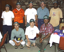
Figure 9: Members of the 2nd International Tsunami Survey Team. Top Row (from left to right): Dr. Yoshinobu Tsuji, University of Tokyo; Dr. Norio Maki, Earthquake Disaster Mitigation Research Center; Dr. Guy Gelfenbaum, United States Geological Survey; Dr. Bruce Jaffe, United States Geological Survey; Michael Nongkas, University of Papua New Guinea. Bottom Row (from left to right): Dr. Hideo Matsutomi, Akita University; Han She-Sub, Korea Meteorological Administration; Dr. Russell Perembo, University of Papua New Guinea.
For more information:
- Dr. Bruce Jaffe [email protected]
- Dr. Guy Gelfenbaum [email protected]