Other ID: OC 17
Status: Completed
Organization(s): USGS, Woods Hole Coastal and Marine Science Center
Funding Program(s):
Principal Investigator(s): Bradford Butman
Affiliate Investigator(s):
Information Specialist(s):
Data Type(s): Imagery: Photo, Location-Elevation: Navigation, Sampling: Biology, Sampling: Geology, Time Series: Mooring (physical oceanography)
Scientific Purpose/Goals: Recover 3 and deploy 3 tripods and floats to monitor sediment transport; obtain XBTs to position the shelf-slope water front; collect water samples for suspended sediment analyses.
Vehicle(s):
Start Port/Location: Woods Hole, MA
End Port/Location: Woods Hole, MA
Start Date: 1976-12-03
End Date: 1976-12-10
Equipment Used: Camera- deep sea, Grab sampler, Loran-C, Bottom platform
Information to be Derived: Time series data; Samples and chemical analysis; Suspended sediment concentrations;
Summary of Activity and Data Gathered: Tripod #116 was dragged 4 miles and damaged approximately 6 days after deployment; however, some good data were obtained. See cruise report for full description. Deployed: 1 current meter (#118 recovered FA 77023 OCEANUS 29 July 6-13, 1977); Deployed: 2 tripods (#119 and 120 both recovered FA 77009 WHITEFOOT March 8 - Apr. 17, 1977); Recovered: 1 current meter (#115 deployed FA 76031 OCEANUS 13 Aug. 12-24, 1976); Recovered: 2 tripods (#116 and 117 both deployed FA 76044 WHITEFOOT Oct. 26-31, 1976); XBT profiles: 83; Transmissometer profiles: 22; Water samples (salinity): 95; Water samples (suspended matter): 65.
Staff: Bradford Butman, William Jaworski, William J. Strahle
Affiliate Staff:
Randy Fabro
John Mclean
Gary Prisby; Bob Beauchamp - BLM; David Stremaitis - ERCO; John Milliman
Carol Parmenter
Lois Toner
John Vermersch - WHOI
Notes: Original Center People field contained: Brad Butman - Ch. Sci.; Randy Fabro, Bill Jaworski, John Mclean, Gary Prisby, William Strahle.
Project = Sediment Dynamics, Sediment Dynamics
Location:
mid-Atlantic Bight, Georges Bank, United States, North America, North Atlantic;
| Boundaries | |||
|---|---|---|---|
| North: 41 | South: 38.4 | West: -73.6 | East: -67.25 |
Platform(s):
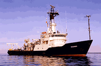
 Oceanus |
Moody, J.A., and Butman, B., 1980, Semidiurnal bottom pressure and tidal currents on Georges Bank and in the Mid-Atlantic Bight: U.S. Geological Survey Open-File Report 80-1137, https://doi.org/10.3133/ofr801137.
Moody, J.A., Butman, B., Beardsley, R.C., Brown, W.S., Daifuku, P., Irish, J.D., Mayer, D.A., Mofjeld, H.O., Petrie, B., Ramp, S., Smith, P., and Wright, W.R., 1984, Atlas of tidal elevation and current observations on the Northeast American continental shelf and slope: U.S. Geological Survey Bulletin 1611, https://doi.org/10.3133/b1611.
| Title | Survey Equipment | Description |
|---|---|---|
| Cruise report | (document not focused on specific equipment) | Chief Scientist's cruise report of ship movement, personnel, equipment and data acquisition. Includes trackmaps, station locations navigation table with information about what data were acquired at each station. |
| Cruise report | (document not focused on specific equipment) | WHOI cruise report with trackmap and personnel list. |
| Survey Equipment | Survey Info | Data Type(s) | Data Collected |
|---|---|---|---|
| Camera- deep sea | --- | Photo | 1976-047-FA-PH-001 (film collection of TRIPOD 120; 19761205-19770318) |
| Grab sampler | --- | Biology Geology | |
| Loran-C | --- | Navigation | |
| Bottom platform | --- | Mooring (physical oceanography) | 1976-047-FA-OM-001 (MAB mooring data) |