Other ID: OC 45
Status: Completed
Organization(s): USGS, Woods Hole Coastal and Marine Science Center
Funding Program(s):
Principal Investigator(s): Bradford Butman
Affiliate Investigator(s):
Information Specialist(s):
Data Type(s): Environmental Data: CTD, Imagery: Photo, Location-Elevation: Navigation, Time Series: Mooring (physical oceanography)
Scientific Purpose/Goals: Recover 4 tripods (#138, 139, 140, and 141) and 3 current moorings (#144, 145, and 146); deploy 2 tripods (#148 and 149) and 2 current moorings (#150 and 151); repair/replace surface marker buoys and lights as necessary; obtain piston and hydrostatically damped cores from Mud Patch south of Martha's Vineyard; and collect CTD, XBT and suspended sediment samples.
Vehicle(s):
Start Port/Location: Woods Hole, MA
End Port/Location: Woods Hole, MA
Start Date: 1978-05-10
End Date: 1978-05-18
Equipment Used: Bottom platform, CTD 19+ with OBS, PAR, DO, Chl, Camera- deep sea, Northstar 6000 LORAN-C
Information to be Derived:
Summary of Activity and Data Gathered: Moorings deployed: 4 (#148,149,150, and 151, recovered FA 78031 ATLANTIS II 103 Sep. 28 - Oct. 5, 1978). Moorings recovered: 7 (#138, 139, 140, 141, 144, 145, and 146, all deployed FA 78001 OCEANUS 38 Jan. 19-26, 1978). XBT: 80; CTD/transmissions: 58; Surface salinity samples: 121; Surface grab samples: 6; Piston cores: 5; Hydrostatically damped cores: 5.
Staff: Michael Bothner, Bradford Butman, Sally Needell, Carol M. Parmenter, Stephanie Pfirman, Richard Rendigs, John West
Affiliate Staff:
Gary Prisby
Nora Thom; Andrew Eliason - Eliason Data Services; Dave Stremaitis - Energy Resources Co.; Jim Broda - WHOI
Notes: Original Center People field contained: Brad Butman - Chief Scientist; Mike Bothner, Carol Parmenter, Stephanie Pfirman, Gary Prisby, Richard Rendigs, Nora Thom, John West, Sally Wood.
Project = Sediment Dynamics, Sediment Dynamics
Location:
Georges Bank, Middle Atlantic continental shelf, United States, North America, North Atlantic;
| Boundaries | |||
|---|---|---|---|
| North: 41.5 | South: 38.5 | West: -74 | East: -67 |
Platform(s):
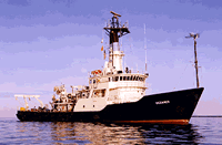
 Oceanus |
Moody, J.A., and Butman, B., 1980, Semidiurnal bottom pressure and tidal currents on Georges Bank and in the Mid-Atlantic Bight: U.S. Geological Survey Open-File Report 80-1137, https://doi.org/10.3133/ofr801137.
Moody, J.A., Butman, B., Beardsley, R.C., Brown, W.S., Daifuku, P., Irish, J.D., Mayer, D.A., Mofjeld, H.O., Petrie, B., Ramp, S., Smith, P., and Wright, W.R., 1984, Atlas of tidal elevation and current observations on the Northeast American continental shelf and slope: U.S. Geological Survey Bulletin 1611, https://doi.org/10.3133/b1611.
| Title | Survey Equipment | Description |
|---|---|---|
| Cruise report | (document not focused on specific equipment) | Chief Scientist's cruise report including daily log, data collection, equipment notes, track chart, surface grab and core sample list, hydrographic station list of XBT's, CTD's and surface salinity samples, and Bridge Loran log. |
| Cruise report | (document not focused on specific equipment) | WHOI cruise report. |
| Survey Equipment | Survey Info | Data Type(s) | Data Collected |
|---|---|---|---|
| Bottom platform | --- | Mooring (physical oceanography) | 1978-010-FA-OM-002 (MAB mooring data) 1978-010-FA-OM-001 (Georges Bank Sediment mooring data) |
| CTD 19+ with OBS, PAR, DO, Chl | --- | CTD | |
| Camera- deep sea | --- | Photo | 1978-010-FA-PH-001 (film collection of TRIPOD 149; 19780511-19781001) |
| Northstar 6000 LORAN-C | --- | Navigation |