Other ID: none
Status: Completed
Organization(s): USGS, Woods Hole Coastal and Marine Science Center
Funding Program(s):
Principal Investigator(s): Bradford Butman
Affiliate Investigator(s):
Information Specialist(s):
Data Type(s): Environmental Data: Temperature, Imagery: Photo, Sampling: Biology, Sampling: Geology, Time Series: Mooring (physical oceanography)
Scientific Purpose/Goals: The WHITEFOOT cruise was part of a continuing study of currents and sediment transport on the U.S. east coast continental shelf. The purpose of the cruise was to recover 2 bottom tripods and deploy 1 tripod on the South Carolina shelf, to conduct hydrographic observations (XBT), to relight 2 surface marker buoys at the tripod site locations, and to obtain samples of surface sediments at the tripod locations.
Vehicle(s):
Start Port/Location: Georgetown, SC
End Port/Location: Georgetown, SC
Start Date: 1978-07-13
End Date: 1978-07-14
Equipment Used: XBT, Camera- deep sea, Grab sampler, Bottom platform
Information to be Derived: Time series data;
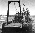
Summary of Activity and Data Gathered: Mooring condition: The tripod had moderate biological growth on the frame and instrument housings. The camera window had several barnacles and a light coating of slime. The transmissometer prism also had a light coating of slime. Some aluminum oxide corrosion had formed on the transmissometer light port. The current rotor and vane were free. There was some difficulty in recovering the tripod through a rear A-frame installed on the WHITEFOOT. The current sensor was damaged on recovery. Although it took several minutes to get the tripod aboard, quick visual observation of the instrument in the water showed several fish inhabiting the savonius rotor current sensor. Crabs, one small octopus, and several fish also inhabited the corner box frames, open structural pipes, and top lifting plate of the tripod. The camera strobe would not fire on deck, indicating malfunction or low batteries. Moorings recovered: 1 (#147 deployed FA 78009 ISELIN Apr. 10-15, 1978). Moorings deployed: 2 (#152 recovered FA 78039 ISELIN Nov. 14-17, 1978; and #153 recovered FA 78038 WHITEFOOT Dec. 13, 1978). Surface salinity samples: 10; Surface grab samples: 2; XBT: 10.
Staff: Bradford Butman, William J. Strahle
Affiliate Staff:
Notes: Original Center People field contained: Brad Butman - Ch. Sci.; William Strahle - Elect. Eng.
Location:
South Carolina shelf, United States, North America, North Atlantic;
| Boundaries | |||
|---|---|---|---|
| North: 33 | South: 32 | West: -79 | East: -78.5 |
Platform(s):
 Whitefoot |
Bothner, M.H., Johnson, P.P., 1981, 210 Pb in sediment cores from the Atlantic continental shelf: estimates of rates of sediment mixing, chapter 3 in Popenoe, P.,ed., Environmental geologic studies on the southeastern United States Atlantic outer continental shelf, 1977-1978: U.S. Geological Survey Open-File Report (81-582-A), https://doi.org/10.3133/ofr81582A.
Gelfenbaum, G., and Noble, M., 1993, Significant bed elevation changes related to Gulf Stream dynamics on the South Carolina continental shelf: Continental Shelf Research, v. 13 no. 4, doi: 10.1016/0278-4343(93)90057-5.
Noble, M.A., and Gelfenbaum, G.R., 1992, Seasonal fluctuations in sea level on the South Carolina shelf and their relationship to the Gulf Stream: Journal of Geophysical Research - Oceans, v. 97 no. C6, URL: http://europa.agu.org/?view=article&uri=/journals/jc/92JC00811.xml&t=noble.
Popenoe, P., 1981, A summary of environmental geologic studies on the southeastern United States Atlantic outer continental shelf, 1977-1978: U.S. Geological Survey Open-File Report (81-583), 45 p., https://doi.org/10.3133/ofr81583.
Popenoe, P., ed., 1981, Appendices of environmental geologic studies on the southeastern United States Atlantic outer continental shelf, 1977-1978: U.S. Geological Survey Open-File Report 81-582-B, https://doi.org/10.3133/ofr81582B.
Popenoe, P., ed., 1981, Environmental geologic studies on the southeastern United States Atlantic outer continental shelf, 1977-1978: U.S. Geological Survey Open-File Report 81-582-A, 15 maps, scale 1:250,000, https://doi.org/10.3133/ofr81582A.
| Title | Survey Equipment | Description |
|---|---|---|
| Cruise report | (document not focused on specific equipment) | Chief Scientist's daily log of ship movement, equipment and data acquisition notes, personnel activities, tripod duration, bottom turbulence duration and intensity, XBT and surface water sample locations, track map including tripod locations. |
| Survey Equipment | Survey Info | Data Type(s) | Data Collected |
|---|---|---|---|
| XBT | --- | Temperature | |
| Camera- deep sea | --- | Photo | 1978-018-FA-PH-001 (film collection of TRIPOD 153; 19780713-19781213) |
| Grab sampler | --- | Biology Geology | |
| Bottom platform | --- | Mooring (physical oceanography) | 1978-018-FA-OM-001 (SAB mooring data) |