Other ID: OC 77
Status: Completed
Organization(s): USGS, Woods Hole Coastal and Marine Science Center
Funding Program(s):
Principal Investigator(s): Bradford Butman
Affiliate Investigator(s):
Information Specialist(s):
Data Type(s): Environmental Data: CTD, Imagery: Photo, Location-Elevation: Navigation, Sampling: Biology, Sampling: Geology, Sonar: Sidescan, Time Series: Mooring (physical oceanography)
Scientific Purpose/Goals: Deploy 5 tripods and current moorings; recover 3 tripods and current moorings; repair/replace surface buoys; conduct cross-shelf CTD sections; obtain bottom grab samples; and conduct a bathymetric and sidescan survey in the Great South Channel.
Vehicle(s):
Start Port/Location: Woods Hole, MA
End Port/Location: Woods Hole, MA
Start Date: 1979-12-13
End Date: 1979-12-20
Equipment Used: Plessey CTD, Klein 531 sidescan, Smith-MacIntyre grab, Camera- deep sea, Northstar 6000 LORAN-C, Bottom platform
Information to be Derived: Time series data; Suspended sediment concentrations; Bathymetric maps;
Summary of Activity and Data Gathered: The 2 tripods and 1 current mooring which we were unable to recover on OCEANUS were recovered in January 1980 with the Tug WHITEFOOT (FA 80001). The release receiver batteries were defective and we could not communicate with the releases. 1 VACM was lost. Because of extensive grappling/search operations we did not have time to recover 1 buoy with current meter at Station B. Christmas and ship deadlines precluded another few hours of shiptime. We elected to deploy the new equipment and recover the instrument later. On return to site in January, the buoy was missing. Deployed tripods: 5 (#183, 184, 185, 186, and 187 all recovered FA 80009 OCEANUS 81 May 23 - Jun. 1, 1980). Deployed current meters: 4 (#188, no recovery information, fishing boat netted buoys and camera Mar. 25, 1980; 189, 190, and 192 all recovered FA 80009 OCEANUS 81 May 23 - Jun. 1, 1980). Recovered tripods: 2 (#176 and 179). Recovered current meters: 2 (#181 and 182). CTDs: 10; XBTs: 49; Surface salinity samples: 57.
Staff: Janet B. Burke, Bradford Butman, Mary E. Hastings, Jeff Kerns, John Larson, Carol M. Parmenter, Richard Rendigs, William J. Strahle, Marlene Noble
Affiliate Staff:
Nick Lefteriou; Andrew Eliason - Eliason Data Services
Notes: Original Center People field contained: Brad Butman - Ch. Sci.; Janet Burke, Jeffrey Kerns, John Larson, Nick Lefteriou, Marlene Noble, Carol Parmenter, Richard Rendigs, Polly Shoukimas, William Strahle.
Project = Sediment Dynamics, Sediment Dynamics
Location:
Georges Bank, Mid-Atlantic Shelf, United States, North America, North Atlantic;
| Boundaries | |||
|---|---|---|---|
| North: 41.49943666 | South: 38.35314502 | West: -73.95028973 | East: -68.8377018 |
Platform(s):
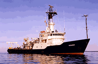
 Oceanus |
Moody, J.A., and Butman, B., 1980, Semidiurnal bottom pressure and tidal currents on Georges Bank and in the Mid-Atlantic Bight: U.S. Geological Survey Open-File Report 80-1137, https://doi.org/10.3133/ofr801137.
Moody, J.A., Butman, B., Beardsley, R.C., Brown, W.S., Daifuku, P., Irish, J.D., Mayer, D.A., Mofjeld, H.O., Petrie, B., Ramp, S., Smith, P., and Wright, W.R., 1984, Atlas of tidal elevation and current observations on the Northeast American continental shelf and slope: U.S. Geological Survey Bulletin 1611, https://doi.org/10.3133/b1611.
Moody, J., B.; Bothner, M.H., 1987, Near-bottom suspended matter concentration on the Continental Shelf during storms: estimates based on in situ observations of light transmission and a particle size dependent transmissometer calibration: Continental Shelf Research, v. 7, no. 6, 609-628 p doi:10.1016/0278-4343(87)90026-4.
| Title | Survey Equipment | Description |
|---|---|---|
| Cruise report | (document not focused on specific equipment) | Chief Scientist's daily log of ship movement, equipment and data acquisition notes, personnel activities, station information, trackmap with CTD and XBT stations, and bridge LORAN log. |
| Survey Equipment | Survey Info | Data Type(s) | Data Collected |
|---|---|---|---|
| Plessey CTD | --- | CTD | |
| Klein 531 sidescan | --- | Sidescan | 1979-035-FA-SO-001 ( Collection of paper record displays of sidescan sonar data for lines ) |
| Smith-MacIntyre grab | --- | Biology Geology | |
| Camera- deep sea | --- | Photo | 1979-035-FA-PH-001 (film collection of TRIPOD 187; 19791219-19800525) |
| Northstar 6000 LORAN-C | --- | Navigation | 1979-035-FA-LN-001-01 (Navigation data) 1979-035-FA-LN-001 (Digital tape(s) of NV, NV-FINAL, NV-NSTAR-FINAL, ) |
| Bottom platform | --- | Mooring (physical oceanography) | 1979-035-FA-OM-001 (Georges Bank Sediment mooring data) |