Other ID: 81
Status: Completed
Organization(s): USGS, Woods Hole Coastal and Marine Science Center
Funding Program(s):
Principal Investigator(s): Bradford Butman
Affiliate Investigator(s):
Information Specialist(s):
Data Type(s): Environmental Data: CTD, Environmental Data: Temperature, Imagery: Photo, Location-Elevation: Navigation, Sampling: Biology, Sampling: Geology, Seismics: Sub Bottom Profiler, Sonar: Sidescan, Sonar: Single Beam, Time Series: Mooring (physical oceanography)
Scientific Purpose/Goals: Recover 5 tripods and 4 current moorings; deploy 3 tripods and 3 current moorings; replace surface buoys; conduct CTDs and XBTs; obtain box cores and surface grabs; conduct preliminary sidescan surveys at Georges Bank sandwave area and head of Lydonia Canyon; conduct hydrographic and suspended sediment transects; and collect bathymetry in Lydonia and Oceanographer Canyons.
Vehicle(s):
Start Port/Location: Woods Hole, MA
End Port/Location: Woods Hole, MA
Start Date: 1980-05-23
End Date: 1980-06-01
Equipment Used: Echosounder, Klein 531 sidescan, XBT, CTD 19+ with OBS, PAR, DO, Chl, Smith-MacIntyre grab, Box corer, Van Veen grab sampler, Gravity corer, Northstar 6000 LORAN-C, 3.5 kHz, Camera- deep sea, Bottom platform
Information to be Derived: Samples and chemical analysis; Grain size analysis; Suspended sediment concentrations; Time series data;
Summary of Activity and Data Gathered: CTD Stations: 43; XBTs: 49; Surface Salinity samples: 93; Navigation: 4 tapes; Box cores: 10; Grab samples: 6; Surface samples: 17. Moorings recovered: 9 (#183, 184, 185, 186, 187, 189, 190, and 192, deployed FA 79035 OCEANUS 77 Dec. 13-20, 1979; and #191, deployed FA 80001 WHITEFOOT Jan. 3-23, 1980). Moorings deployed: 6 (#193, 194, 196, 197, and 198 all recovered FA 80030 OCEANUS 88 Oct. 23-31, 1980; and #195 recovered FA 80034 OCEANUS 90 Nov. 24 - Dec. 3, 1980).
Staff: Michael Bothner, Cynthia Bryden, Bradford Butman, John Larson, Carol M. Parmenter, Richard Rendigs, David Twichell, Marlene Noble
Affiliate Staff:
Gerard McCarthy
Frank Musialowski; WHOI: Fred Grassle
Linda Porteous
Notes: Original Center People field contained: Brad Butman, Chief Scientist; Mike Bothner, Cynthia Bryden, John Larson, Gerard McCarthy, Frank Musialowski, Marlene Noble, Carol Parmenter, Richard Rendigs, Dave Twichell.
Location:
Mid-Atlantic Shelf, Great South Channel, southern flank Georges Bank, Oceanographer Canyon, Lydonia Canyon, Atlantic Continental Shelf, United States, North America, North Atlantic;
| Boundaries | |||
|---|---|---|---|
| North: 41.25 | South: 38.45 | West: -74 | East: -67.15 |
Platform(s):
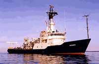
 Oceanus |
Butman, B., and Moody, J.A., 1984, Bathymetric map of Lydonia Canyon, U.S. Atlantic Outer Continental Shelf: U.S. Geological Survey Miscellaneous Field Studies Map 1710, https://doi.org/10.3133/mf1710.
Moody, J., B.; Bothner, M.H., 1987, Near-bottom suspended matter concentration on the Continental Shelf during storms: estimates based on in situ observations of light transmission and a particle size dependent transmissometer calibration: Continental Shelf Research, v. 7, no. 6, 609-628 p doi:10.1016/0278-4343(87)90026-4.
| Title | Survey Equipment | Description |
|---|---|---|
| Cruise report | (document not focused on specific equipment) | Chief Scientist's cruise report including personnel, equipment, daily log of work, mooring locations, surface sample locations, trackmaps including station locations, and a table of stations indicating what data was collected at each station.Additionally, the Loran Log is included. |
| Cruise report | (document not focused on specific equipment) | WHOI cruise report. |
| Survey Equipment | Survey Info | Data Type(s) | Data Collected |
|---|---|---|---|
| Echosounder | --- | Single Beam | 1980-009-FA-BA-001 (Digital tapes of BT data: inv. # 0940 and 2217.) |
| Klein 531 sidescan | --- | Sidescan | 1980-009-FA-SO-002 (microfilm of ) 1980-009-FA-SO-001 ( Collection of paper record displays of sidescan sonar data for lines ) |
| XBT | --- | Temperature | |
| CTD 19+ with OBS, PAR, DO, Chl | --- | CTD | 1980-009-FA-OM-001 (Digital tapes of CTD STATION DATA.) |
| Smith-MacIntyre grab | --- | Biology Geology | |
| Box corer | --- | Biology Geology | |
| Van Veen grab sampler | --- | Geology | |
| Gravity corer | --- | Geology | |
| Northstar 6000 LORAN-C | --- | Navigation | 1980-009-FA-LN-001-01 (Cruise track map.) 1980-009-FA-LN-002-01 (Navigation data) |
| 3.5 kHz | --- | Sub Bottom Profiler | 1980-009-FA-SE-001 (microfilm of ) 1980-009-FA-SE-002 (analog tape of seismic data) |
| Camera- deep sea | --- | Photo | 1980-009-FA-PH-001 (film collection of TRIPOD 195; 19800527-19801202) |
| Bottom platform | --- | Mooring (physical oceanography) | 1980-009-FA-OM-003 (MAB mooring data) 1980-009-FA-OM-002 (Georges Bank Sediment mooring data) |