Other ID: OC108 LEGS 1 and 2; BLM M-2; BTF M-2
Status: Completed
Organization(s): USGS, Woods Hole Coastal and Marine Science Center
Funding Program(s):
Principal Investigator(s): Richard Rendigs
Affiliate Investigator(s): Michael Rawson - LDGO
Information Specialist(s):
Data Type(s): Environmental Data: Temperature, Imagery: Photo, Location-Elevation: Navigation, Sampling: Biology, Sampling: Geology, Time Series: Mooring (physical oceanography)
Scientific Purpose/Goals: Cruise BLM M-2 was the second in the seasonal sampling series to collect infauna and benthic sediment samples to be used as baseline analyses for the Georges Bank Lease Sale No. 42 Environmental Monitoring Program. The major emphasis of the program will determine the extent of deposition and accumulation of toxic materials as a result of oil drilling activities and any subsequent effects on the benthic biota.
Vehicle(s):
Start Port/Location: Woods Hole, MA
End Port/Location: Woods Hole, MA
Start Date: 1981-11-09
End Date: 1981-11-20
Equipment Used: Dredge, XBT, Camera- deep sea, 35 mm camera, Loran-C, Bottom platform
Information to be Derived: Time series data; Samples and chemical analysis;
Summary of Activity and Data Gathered: The cruise, due to some weather problems, was accomplished in two legs: Leg 1, 11/09/82 - 11/15/81; Leg 2, 11/17/81 - 11/20/81. The major portion of the data collection were sediment grab samples for chemical and biological analysis. The actual number of samples varied for the regional and site specific stations as did the need for camera stations at each site. Epibenthic trawls were undertaken using the Day Dredge with 1/2 inch mesh nylon netting liner to recover bivalves for tissue analysis. Water samples for DO and salinity were taken at near-bottom and surface depths at each regional site. XBT casts were made at each regional site.. With the exception of the camera sampling (because of earlier instrument loss), all primary site-specific stations were successfully completed. Due to weather and ship-time availability constraints not all of the proposed secondary site-specific stations were sampled. Mooring deployed: 1 (#239, recovered by fishing trawler ELIZABETH Nov. 10, 1981). Sediment samples: 63.
Staff: Paul Bowker, Carol M. Parmenter, Lawrence Poppe, Richard Rendigs, William J. Strahle
Affiliate Staff:
David Brewster; BLM: Phillip Thomas
Jeffrey Hyland; WHOI: Rosemarie Petrecca; LDGO: Michael Rawson
John Erhard
Bill Hunneke
David Keil
Notes: Original Center People field contained: Carol Parmenter, Richard Rendigs, William Strahle, Paul Bowker, David Brewster, Lawrence Poppe.
Project = Georges Bank Drilling Project, Georges Bank Drilling Project
Location:
Georges Bank, Lydonia Canyon, United States, North America, North Atlantic;
| Boundaries | |||
|---|---|---|---|
| North: 41.6 | South: 40.35 | West: -70.25 | East: -67.1 |
Platform(s):
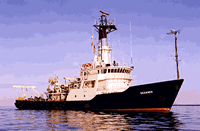
 Oceanus |
| Title | Survey Equipment | Description |
|---|---|---|
| Cruise report | (document not focused on specific equipment) | Chief Scientist's cruise report of personnel, sampling program, cruise narrative, and a tables of stations with locations and comments on data acquisition. |
| Survey Equipment | Survey Info | Data Type(s) | Data Collected |
|---|---|---|---|
| Dredge | --- | Biology Geology | |
| XBT | --- | Temperature | |
| Camera- deep sea | --- | Photo | |
| 35 mm camera | --- | Photo | 1981-038-FA-PH-001 (Deck photos of field activity operations) |
| Loran-C | --- | Navigation | 1981-038-FA-LN-001 (Digital tape(s) of NV-FINAL, NV-SAT, ) |
| Bottom platform | --- | Mooring (physical oceanography) | 1981-038-FA-OM-001 (Lydonia Canyon mooring data) |