Other ID: OC130
Status: Completed
Organization(s): USGS, Woods Hole Coastal and Marine Science Center
Funding Program(s):
Principal Investigator(s): Bradford Butman
Affiliate Investigator(s):
Information Specialist(s):
Data Type(s): Location-Elevation: Navigation, Sampling: Biology, Sampling: Geology, Sonar: Single Beam, Time Series: Mooring (physical oceanography)
Scientific Purpose/Goals: 1. Recover 2 subsurface moorings and 1 bottom tripod system deployed in Lydonia Canyon. This recovery completed the 2-year field measurement program in Lydonia and Oceanographer Canyons. 2. Recover 3 sediment-trap moorings deployed near Mobil Block 312. This array was designed to measure the resuspension and transport of drill muds discharged during drilling. 3. Deploy 5 subsurface moorings on the continental slope. This array initiates a large study of currents and sediment movement along the outer shelf, continental slope, and upper rise. 4. Conduct a detailed hydrographic survey around Lydonia and Oceanographer Canyons and along the continental slope in support of objectives 1 and 3. 5. Obtain hydrostatically damped cores in the Mud Patch, Lydonia Canyon, and around Lease Block 312 to document the vertical distribution of drill muds in surficial sediments. 6. Obtain surface grab samples around Lydonia and Oceanographer Canyons to refine surface-sediment texture map. 7. Recover 5 surface marker buoys deployed to mark instrument sites.
Vehicle(s):
Start Port/Location: Woods Hole, MA
End Port/Location: Woods Hole, MA
Start Date: 1982-11-09
End Date: 1982-11-16
Equipment Used: Grab sampler, Gravity corer, Northstar 6000 LORAN-C, 12 kHz, Bottom platform
Information to be Derived:
Summary of Activity and Data Gathered: All work for OC 130 was completed. Deployed moorings: 6 (#266, 267, 268, 269, 270, and 271). Recovered moorings: 7 (#258, 259, 260, 261, 262, 264, and 266). Recovered buoys: (A, C, E, P, R, and V). CTDs: 33; XBTs: 41; Surface salinity samples: 68; Surface nutrient samples: 32; Suspended sediment samples: 16; Oxygen samples: 12; VanVeen grab samples: 10; Hydraulically damped cores: 1; Bathymetry.
Staff: Michael Bothner, Bradford Butman, Mary E. Hastings, John Larson, Carol M. Parmenter, Richard Rendigs, William J. Strahle, Marlene Noble
Affiliate Staff:
Frank Musialowski
Michael Pickering; H. Suzanne Bolton - USGS House Subcommittee; Andrew Eliason - Eliason Data Services
Notes: Original Center People field contained: Brad Butman, Mike Bothner, John Larson, Frank Musialowski, Marlene Noble, Carol Parmenter, Michael Pickering, Richard Rendigs, Mary Polly Shoukimas, William Strahle.
Project = Sediment Dynamics, Sediment Dynamics
Location:
Lydonia Canyon, Oceanographer Canyon, Mud Patch, Lease Block 312, North Atlantic Continental Slope, United States, North America, North Atlantic;
| Boundaries | |||
|---|---|---|---|
| North: 41.19361 | South: 39.83333 | West: -70.8028 | East: -67.33333 |
Platform(s):
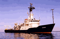
 Oceanus |
Butman, B., 1988, North Atlantic Slope and Canyon Study—Volume 1, Executive summary: U.S. Geological Survey Open-File Report 88-027-A, https://doi.org/10.3133/ofr8827A.
Butman, B., and Moody, J.A., 1984, Bathymetric map of Lydonia Canyon, U.S. Atlantic Outer Continental Shelf: U.S. Geological Survey Miscellaneous Field Studies Map 1710, https://doi.org/10.3133/mf1710.
Butman, B., Moody, J.A., and Conley, S.J., 1986, Hydrography of the New England shelf and slope—data report for R/V Oceanus cruise 130, November 1982: U.S. Geological Survey Open-File Report 86-101, https://doi.org/10.3133/ofr86101.
| Title | Survey Equipment | Description |
|---|---|---|
| Cruise report | (document not focused on specific equipment) | Chief Scientist's cruise report including personnel, ship movement, cruise narrative, data acquisition and equipment performance notes, grab sample identifiers and positions, hydrographic data (XBT, CTD, salinity, nutrients, suspended sediment) positions, trackmaps, and bridge Loran notes. |
| Survey Equipment | Survey Info | Data Type(s) | Data Collected |
|---|---|---|---|
| Grab sampler | --- | Biology Geology | |
| Gravity corer | --- | Geology | |
| Northstar 6000 LORAN-C | --- | Navigation | 1982-037-FA-LN-001 (Digital tape(s) of NV-EDIT, NV-NSTAR-UNEDIT, CTD STATION DATA, ) |
| 12 kHz | --- | Single Beam | 1982-037-FA-SE-001 ( Collection of paper record displays of seismic data( E/S) for lines ) |
| Bottom platform | --- | Mooring (physical oceanography) | 1982-037-FA-OM-002 (NE slope mooring data) 1982-037-FA-OM-001 (Digital tape(s) of NV-EDIT, NV-NSTAR-UNEDIT, CTD STATION DATA, ) |