Other ID: 86-2; JSL 1818
Status: Completed
Organization(s): USGS, Woods Hole Coastal and Marine Science Center
Funding Program(s):
Principal Investigator(s): Bradford Butman
Affiliate Investigator(s):
Information Specialist(s):
Data Type(s): Location-Elevation: Navigation, Time Series: Mooring (physical oceanography)
Scientific Purpose/Goals: Recover USGS mooring 301, deployed in Rodgers Pass in the Gulf of Maine.
Vehicle(s):
Start Port/Location: Woods Hole, MA
End Port/Location: Woods Hole, MA
Start Date: 1986-07-20
End Date: 1986-07-22
Equipment Used: Loran-C, Bottom platform
Information to be Derived: Mooring recovery;
Summary of Activity and Data Gathered: Mooring recovered: 1 (#301 deployed FA 85024 GYRE July 24-26, 1985). Page Valentine agreed to use submersible JOHNSON SEA-LINK on the first day of his Georges Bank cruise (detailed in cruise report 86011). SEA-LINK successfully released mooring 301.
Staff: Bradford Butman, John Moody
Affiliate Staff:
Notes: Submersible used to recover mooring part was part of Page Valentine's cruise, FA 86011.
Location:
Rodgers Pass, Gulf of Maine, United States, North America, North Atlantic;
| Boundaries | |||
|---|---|---|---|
| North: 42.65528419 | South: 42.43111534 | West: -68.89765467 | East: -68.57454466 |
Platform(s):
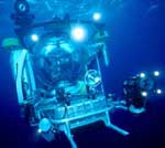 Johnson Sea-link | Mary Louise |
| Title | Survey Equipment | Description |
|---|---|---|
| Cruise report | (document not focused on specific equipment) | Chief scientist's cruise report including personnel, daily narrative, cruise highlights, and trackmap. |
| Survey Equipment | Survey Info | Data Type(s) | Data Collected |
|---|---|---|---|
| Loran-C | --- | Navigation | |
| Bottom platform | --- | Mooring (physical oceanography) | 1986-012-FA-OM-001 (Gulf of Maine mooring data) |
