Other ID: none
Status: Completed
Organization(s): USGS, Woods Hole Coastal and Marine Science Center
Funding Program(s):
Principal Investigator(s): William J. Strahle
Affiliate Investigator(s):
Information Specialist(s):
Data Type(s): Location-Elevation: Navigation, Time Series: Mooring (physical oceanography)
Scientific Purpose/Goals: Recover 2 VACM current meter moorings, 1 GEOPROBE, and three surface markers.
Vehicle(s):
Start Port/Location: Sausalito, CA
End Port/Location: Redwood City, CA
Start Date: 1989-10-13
End Date: 1989-10-14
Equipment Used: Loran-C, GEOPROBE
Information to be Derived: Time series data;
Summary of Activity and Data Gathered: Recovered moorings: 2 (#334 and 335, deployed FA 89009 FARNELLA May 4-15, 1989).
Staff: William J. Strahle
Affiliate Staff:
David Drake (PMG)
JoAnn Thede (PMG)
John Erikson (PMG)
Notes: Project = Farallon Islands, Farallon Islands
Location:
Farallon Islands, California, United States, North America, North Pacific;
| Boundaries | |||
|---|---|---|---|
| North: 37.78886522 | South: 37.68110281 | West: -122.9428893 | East: -122.79015843 |
Platform(s):
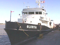
 Glorita |
| Title | Survey Equipment | Description |
|---|---|---|
| Cruise report | (document not focused on specific equipment) | Chief Technician's cruise report including personnel, objective, equipment, and tabulated information. |
| Survey Equipment | Survey Info | Data Type(s) | Data Collected |
|---|---|---|---|
| Loran-C | --- | Navigation | |
| GEOPROBE | --- | Mooring (physical oceanography) | 1989-031-FA-OM-001 (Farallones mooring data) |