Other ID: SPRL93-1,S-3-93-SC
Status: Completed
Organization(s): USGS, Woods Hole Coastal and Marine Science Center
Funding Program(s):
Principal Investigator(s): William J. Strahle
Affiliate Investigator(s):
Information Specialist(s):
Data Type(s): Time Series: Mooring (physical oceanography), Location-Elevation: Navigation
Scientific Purpose/Goals: Current meters
Vehicle(s):
Start Port/Location:
End Port/Location:
Start Date: 1993-03-27
End Date: 1993-04-02
Equipment Used: Bottom platform, navigation
Information to be Derived: Time series data;
Summary of Activity and Data Gathered: Moorings recovered: 4 (#409, 410, 411 and 412, deployed FA 92039 SPROUL Dec. 9-10, 1992).
Staff: Barbara A. Seekins, William J. Strahle
Affiliate Staff:
Notes: No field activity reports; information derived from mooring log.
Staff information imported from InfoBank
Bill Strahle (USGS Woods Hole) - Chief Scientist
Location:
California Palos Verdes
| Boundaries | |||
|---|---|---|---|
| North: 33.73380981 | South: 33.70772868 | West: -118.41850235 | East: -118.35167968 |
Platform(s):
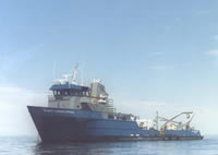
 Robert Gordon Sproul |
| Survey Equipment | Survey Info | Data Type(s) | Data Collected |
|---|---|---|---|
| Bottom platform | --- | Mooring (physical oceanography) | 1993-005-FA-OM-001 (mooring data) |
| navigation | --- | Navigation |