Other ID: OC296
Status: Completed
Organization(s): USGS, Woods Hole Coastal and Marine Science Center
Funding Program(s):
Principal Investigator(s): Marinna Martini, William J. Strahle
Affiliate Investigator(s): Ronald Schlitz - NMFS
Information Specialist(s):
Data Type(s): Time Series: Mooring (physical oceanography)
Scientific Purpose/Goals: Deploy GLOBEC moorings #482, 483, 484, 485, 486, 487, 488, 489, 490, 491, 492, 493, and 494 in Great South Channel.
Vehicle(s):
Start Port/Location: Woods Hole, MA
End Port/Location: Woods Hole, MA
Start Date: 1997-01-12
End Date: 1997-01-17
Equipment Used: Bottom platform
Information to be Derived: Time series data;
Summary of Activity and Data Gathered: Moorings deployed: 13 (#482, 483, and 484, recovered FA 97034 OCEANUS OC306 Jun. 19-22, 1997 and redeployed with same number; #485 recovered Nov. 5, 1997 by NOAA vessel, no information; #486, 487, 489, 490, 492, and 493, recovered FA 97039 OCEANUS OC311 Aug. 16-27, 1997; #488 and 491 LOST, no information; #494 recovered Mar. - Apr. 1997, no information, redeployed FA 97034 OCEANUS Jun. 19-22, 1997, no recovery information).
Staff: Dann Blackwood, Peter W. Gill, Marinna Martini, Richard Rendigs, William J. Strahle
Affiliate Staff:
NMFS: Ronald Schlitz - co-Chief Sci.
James Manning; NOAA: Judith Gray; Eliason Data WHOI: Steven Cross
Lauren Stein; Bowdoin College: Jennifer Frese
Notes: Information derived from pre-field activity report and mooring log.
Location:
Great South Channel, Georges Bank, United States, North America, North Atlantic;
| Boundaries | |||
|---|---|---|---|
| North: 40.9 | South: 40.2 | West: -69.2 | East: -68 |
Platform(s):
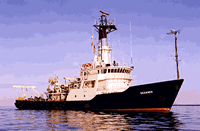
 Oceanus |
| Survey Equipment | Survey Info | Data Type(s) | Data Collected |
|---|---|---|---|
| Bottom platform | --- | Mooring (physical oceanography) | 1997-008-FA-OM-001 (Great South Channel mooring data) |