Other ID: OC320
Status: Completed
Organization(s): USGS, Woods Hole Coastal and Marine Science Center
Funding Program(s):
Principal Investigator(s): Richard Signell
Affiliate Investigator(s): Neal Pettigrew - U. Maine, Orono
Information Specialist(s): Frances Lightsom
Data Type(s): Time Series: Mooring (physical oceanography)
Scientific Purpose/Goals: Deploy 4 USGS and 3 U. Maine moorings in the Gulf of Maine.
Vehicle(s):
Start Port/Location: Woods Hole, MA
End Port/Location: Woods Hole, MA
Start Date: 1998-03-30
End Date: 1998-04-03
Equipment Used: Bottom platform
Information to be Derived: Time series data;
Summary of Activity and Data Gathered: 44 CTD stations were also occupied due to a strong river discharge event during the cruise. See web page for station and mooring locations, maps, photos, CTD survey info and more. Moorings deployed: 7 (#520 and 521, both recovered FA 98062 OCEANUS 328-2A, Aug. 6-17,1998; #522, 523, 524 and 525, all recovered FA 98036 OCEANUS 328-1, Aug. 4-6, 1998; and #526 recovered Jul. 6, 1998, no recovery information).
Staff: Marinna Martini, Richard Signell
Affiliate Staff:
University of Maine (Orono
ME): Neal Pettigrew (chief scientist)
David Townsend
John Wallinga
Robert Stessel
Peter Brickley
Scott Boone; WHOI: Laura Stein
Notes: Original Center People field contained: Rich Signell, co-chief scientist; Marinna Martini, operations chief.
Project = ECOHAB-GOM, ECOHAB-GOM
Location:
Gulf of Maine, United States, North America, North Atlantic,
| Boundaries | |||
|---|---|---|---|
| North: 43.75 | South: 43.5 | West: -69.9 | East: -67.6 |
Platform(s):
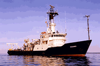
 Oceanus |
| Survey Equipment | Survey Info | Data Type(s) | Data Collected |
|---|---|---|---|
| Bottom platform | --- | Mooring (physical oceanography) | 1998-025-FA-OM-001 (ECOHAB II mooring data) |